In December, I wrote about the five new commercial UAS (Unmanned Aerial System) exemptions issued by the Federal Aviation Administration (FAA), with one commercial exemption being issued to Trimble Navigation for its UX5 mapping UAS. The precedent was a major step towards integrating commercial UAS operations into the United States airspace. This month, the FAA issued two more commercial UAS exemptions, one of them opening a new world of commercial UAS operations.
Speaking of exemptions, there’s a pile of commercial UAS exemption requests awaiting review by the FAA. From Amazon.com, who garnered lots of UAS attention when television news magazine 60 Minutes interviewed Amazon CEO Jeff Bezos about its drone delivery concept, to Agribusiness giant Wilbur-Ellis Co. If you’d like to view the list of requestors as well as read their submissions, click here. How much time does it take from submission to a exemption approval? The FAA doesn’t provide that estimate, but I’ve spoken to several organizations that have been granted exemptions and Certificates of Waiver or Authorization (COA). The quickest timeline I’ve heard is three months.
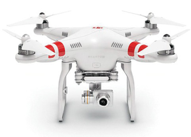
The Phantom 2 Vision+ UAS
As I mentioned above, two new commercial UAS exemptions were issued earlier this month. One went to Advanced Aviation Solutions LLC, who was granted an exemption to fly the Swiss-made eBee Ag UAS for precision agriculture. At US$25,000 each, the eBee Ag is for the serious drone connoisseur.
The other commercial UAS exemption was issued to a realtor in Tucson, Arizona. This exemption is interesting because it’s the first one issued that makes use of the DJI Phantom II Vision+ quad copter UAS. The Phantom II Vision + sells for well under US$2,000 and is generally considered a consumer UAS rather than one purpose-built for commercial users. However, it clearly has the capability of being used by realtors, and thanks to support by Pix4D, a Swiss-based commercial UAS imagery software maker, it can be used for capturing imagery for mapping and generating 3D models.
At well under $2,000, the DJI Phantom II Vision+ price point is affordable for even the most basic commercial UAS application. The cost is relatively insignificant compared to the cost of image processing software from PIX4D, which at US$7,500 is more than five times the cost of the Phantom.
No matter which model UAS is being approved in the exemptions, the FAA expects all operators to adhere to many rules in common. One is that the Pilot in Command (PIC) must possess at least an FAA Private Pilot certificate. What does it take to qualify for an FAA Private Pilot Certificate? It’s not a small or inexpensive undertaking. Generally speaking, you need to:
Pass a written knowledge test after completing ground school.
Accumulate 40 hours of flight instruction and solo flight time.
Possess an FAA third-class medical certificate.
Pass a flight test administered by an FAA examiner.
In terms of cost, a typical small aircraft (Cessna 152) suitable for training will cost you upwards of $90/hour to rent (including fuel). Add all the other costs in and you’re looking at spending more than $10,000. This doesn’t include the time you will spend studying, and there’s a lot to study, from weather phenomena to instruments to aircraft performance to maps.
Now, the FAA exemptions don’t specify that the exemption holder must have a Private Pilot certificate. If you possess such an exemption, you can hire a Private Pilot to act as Pilot in Command (PIC) of the UAS, but costs start adding up quickly if you have to hire a PIC and also have a Visual Observer (VO) present, which the exemptions are requiring.
Things are certainly heating up in the commercial UAS world. I have to commend the FAA for stepping up to the plate and taking action to allow commercial UAS operations (however limited) well before the U.S. Congress-imposed deadline of September 2015 for releasing rules for integrating commercial UAS into the United States airspace.
Esri has added geodemographic informationfor 57 additional countries to its ready-to-use ArcGIS apps, including Esri Business Analyst Online (BAO) and Esri Community Analyst. Up-to-date population, income, employment, and consumer spending information helps businesses — including retailers, real estate brokers, merchandisers, supply chain managers, and marketers — better understand local markets all around the world, the company said.
“In today’s global economy, organizations are interested in providing the best services and goods to customers in more than one area,” said Simon Thompson, director of commercial business at Esri. “Esri’s comprehensive data provides the insight organizations need to do business at a hyperlocal level and really meet the needs and demands of local consumers.”
The newly added countries include those in Latin America and Africa, bringing the total number of countries to 137. In addition, Canadian data has been updated to include 2014 updates, and Australia, France, Germany, and India now have advanced datasets and new reports including household, population, and summary data.
See a comprehensive list of global Esri Demographic data, and visit Esri booth 3171 at the National Retail Federation show in New York’s Jacob K. Javits Convention Center, January 11–13.
Users can create and customize maps with a new ribbon bar interface and redesigned managers.
Golden Software has released MapViewer 8, which is says has numerous enhancements over its predecessor program. Enhancements inlcude new map types, increased file compatibility, the ability to download base maps from online servers, enhanced querying functionality, and a new user interface.
MapViewer is a mapping and spatial analysis tool that allows users to produce publication-quality thematic maps. Users can precisely display their data distribution with intuitive functions and features.
Golden Software is offering a free demo download so customers can try out the new features with their own data.
The new bivariate option for the symbol map can create visually dynamic maps that display variables in an easy-to-understand way. This map, from beta tester Thierry Hatt, displays house surface area as symbol size and percentage of house surface area divided by property surface area as symbol color for Strasbourg, Alsace, France (1765 land survey information).
Getmapping has released version 6 of its multi-featured Online GIS program. The new version has been enhanced with support for worldwide projections, a module for publishing Inspire-compliant WMS/WFS and a new module for Getmapping’s panoramic imagery product, Street Layer. Getmapping’s Online GIS, together with its associated cloud storage and built-in national mapping layers, allows organizations to share information across their users and clients anywhere in the world.
Support within the Online GIS for worldwide projections now opens up the solution to users around the world, and the software has already been deployed in a number of countries including Uganda, Kenya and South Africa. This, together with the fact that the product can be white-labeled, also opens up significant partnering opportunities, the company said.
Getmapping Online GIS can be used as an organization’s primary web mapping tool to share a range of map layers including aerial imagery, local mapping, environmental data, and the customer’s own data, taking advantage of Getmapping’s high speed data center. It can also perform key GIS tasks such as address searching, measuring, spatial analysis and printing to scale. It can provide everyone within an organization with access to the company’s map information, helping them to do their job more efficiently.This removes the burden of installing traditional GIS software, which is often expensive and difficult to learn, the company said.
To assist local government with meeting and exceeding their Inspire obligations, a new Inspire cloud service has been built based on the Getmapping Online GIS technology. Several key features are included to simplify the process of becoming Inspire compliant including a geodata layer uploader, built-in data editing (which is instantly visible), a metadata importer and editor as well as Data.gov.uk harvesting to enable “discovery, view and download” services within a few minutes. Competitively priced and easy to deploy, Inspire Cloud will have customers publishing map layers within a short amount of time, the company said.
Street Layer is another Getmapping product now fully integrated into the Online GIS platform. It allows accurately positioned panoramic images to be viewed alongside high quality mapping.With the added benefits of 3D measurement tools and GIS overlay capabilities, Street Layer has proven itself in a variety of applications including local government; policing, fire and rescue; insurance risk and claim validation; and local community work. Key uses have included measuring the distance from a street to a door, the height of a building or asset, the differences between different years of imagery, as well as improving the quality of asset databases. Trial accounts, including sample data of your area of interest, are now available.
“The enhancements that we have introduced to our Online GIS platform are really significant,” said Dave Horner, managing director of Getmapping. “Customers not only benefit from a simple to use application with access to cloud-hosted aerial photography, integration with address gazetteers and national mapping but also now the Street Layer panoramic imagery which in many cases eliminates the need for a site visit. Worldwide projections are now also supported meaning we have a product that can be used anywhere in the world, and we are already seeing the benefits for some of our African customers. Finally, the Inspire Cloud module helps organizations that need to publish data become Inspire compliant.”
Leica Geosystems has released the Leica DISTO E7500 laser distance meter, a tool for anyone who needs easy, precise measurements outdoors. An advanced digital Pointfinder and 4x zoom enables users to take measurements with high accuracy up to a 500-foot range in all light conditions. This capability is a distinct advantage when working outside in sunny weather; even if the red laser point is no longer visible, the target can easily be seen on the tool’s full-color display, Leica said.
The housing and keypad are sealed against water and dust, and certification to the rigorous IP65 rating allows use in adverse weather conditions. It can also be cleaned under running water.
A Smart Horizontal Mode enables the DISTO E7500 to provide an accurate result even when encountering obstructions such as walls, hedges or people. One measurement to the target is enough for the required horizontal distance to appear on the display, Leica said.
Other capabilities include automatic calculation of volumes or areas, two programmable favorites keys, timer delay, a 30-position memory, an offset function, and 15 options for units of measure.
The Leica DISTO E7500 is certified to ISO Standard 16331-1 for precision and performance in everyday use on the jobsite.
CNN has entered into a Cooperative Research and Development Agreement (CRDA) with the Federal Aviation Administration to advance efforts to integrate unmanned aerial vehicles (UAVs) into newsgathering and reporting.
The cooperation arrangement will integrate efforts from CNN’s existing research partnership with the Georgia Tech Research Institute (GTRI). Coordination between and among CNN, GTRI and the FAA has already begun. The FAA will use data collected from this initiative to formulate a framework for various types of UAVs to be safely integrated into newsgathering operations.
“Our aim is to get beyond hobby-grade equipment and to establish what options are available and workable to produce high quality video journalism using various types of UAVs and camera setups,” said CNN Senior Vice President David Vigilante. “Our hope is that these efforts contribute to the development of a vibrant ecosystem where operators of various types and sizes can safely operate in the US airspace.”
“Unmanned aircraft offer news organizations significant opportunities,” said FAA Administrator Michael Huerta. “We hope this agreement with CNN and the work we are doing with other news organizations and associations will help safely integrate unmanned newsgathering technology and operating procedures into the National Airspace System.”
The International LiDAR Mapping Forum, set for February 23-25 in Denver, is a technical conference and exhibition focused on data acquisition, fusion, processing and point clouds for aerial surveying and mapping used to support transport, urban modeling, coastal zone mapping, utility asset management, and more.
Geospatial Technology Trends. ILMF is considered by many the premier conference for the latest geospatial technological developments, from innovations in photogrammetry to advances in aerial LiDAR systems. Attendees can explore an international exhibition of leading hardware and software suppliers showing their newest releases, and attend sessions where more than 60 experts will present best practices and case studies for cutting-edge technologies such as:
Geiger-Mode LiDAR
Focal Plane Array (FPA) LiDAR
Mobile Mapping Systems (MMS)
Unmanned Aerial Vehicles
Focus on UAVs. This year, ILMF features a UAV workshop and pavilion, where industry leaders discuss the current regulatory landscape and legal guidelines, UAVs versus aerial LiDAR, training and insurance considerations and more. Additional program content will cover topics like “Does Camera Quality Matter in sUAS Photography?” and “LiDAR Scanning with Supplementary UAV Captured Images for Structural Inspections.”
Other topics covered at the conference include:
Data fusion
Extracting from point clouds
Managing large data sets/point clouds
Airborne, terrestrial and bathymetric LiDAR
Coastal zone, defense and flood plain LiDAR
Corridor and utilities mapping
Data classification, GIS
Organizers say participants can gain much from networking with and gaining valuable information from other precision-measurement and imaging professionals across disciplinary lines. Attendance at ILMF 2015 is expected to exceed 800, and will include professionals from these organizations who have already registered:
We’ve all been waiting with bated breath for the Federal Aviation Administration (FAA) to release its long-awaited regulations to enable safe operation of unmanned aircraft systems (UAS) in United States airspace. Well, probably only a small subset of us actually have been anxiously awaiting these FAA rules, but with the increasing visibility of even small UAS on TV, most of us have probably given these things some passing thought.
If you didn’t already know, the FAA has been mandated by Congress to integrate UAS into the National Airspace System (NAS) by September 30 of this year.
I’ve been following what’s been going on quite intently as far as FAA regulations for UAS. For the most part, the FAA has been making noises that it has not been able to maintain the planned schedule to achieve this objective. The UAS industry — and GNSS is a major component for that industry — has been quite disappointed by the FAA’s progress and has made quite a deal about the delays and lack of concrete results. So, for me, it seemed to be a good sign when the FAA recently started to issue restricted exemptions from its existing rules for regular manned aircraft, which may allow people to legally use UAS, for:
TV and movie making (7 exemptions),
Construction site monitoring (1 exemption)
Precision aerial surveys (3 exemption granted to Trimble and Woopert Inc.)
Flare stack inspections on 14 Shell Oil Gulf of Mexico production platforms (1 exemption)
Aerial video to augment real-estate listings (1 exemption)
Photogrammetry and crop surveying for precision agriculture (1 exemption)
As of January 9, that’s the list, but — given that the FAA has found this way to move forward on an individual basis to allow commercial UAS use — it’s quite likely there may be more. I pulled up these exemptions on the FAA unmanned aircraft systems site, which lists exemptions granted so far and explains the Section 333 regulation under which the FAA has chosen to proceed.
It seems the exemptions are being done now because the overarching regulations to integrate small UAS (sUAS) into routine NAS operations have still not made it out of the FAA barn — even following several years now since it was due to emerge. It’s once again scheduled for release for comment “later this year.” The FAA site goes on to say,
Section 333, “Special Rules for Certain Unmanned Aircraft Systems,” provides flexibility for authorizing safe civil operations in the NAS by granting the Secretary of Transportation the authority to determine whether airworthiness certification is required for a UAS to operate in the NAS.
The FAA regulations that govern today’s aircraft are found in Title 14 of the Code of Federal Regulations (14 CFR). There are 68 regulations organized into three volumes. A fourth volume deals with the Department of Transportation, and a fifth volume is focused on NASA.
Three primary regulations govern the airworthiness of an aircraft.
The “Big Three” are:
14 CFR Part 21 — Certification Procedures for Products and Parts
14 CFR Part 43 — Maintenance, Preventive Maintenance, Rebuilding, and Alterations
14 CFR Part 91 — General Operating and Flight Rules
These contain massive volumes of rules and regulations that govern everything from markings on the outside of the air vehicle, when and how often maintenance should be performed and even the parts to be used, all the way up to the qualifications needed by pilots for General Aviation and Commercial Transport aircraft operation.
Exemption No. 11138 has been granted to Realtor Douglas Trudeau of Tierra Antigua Realty in Arizona. Most people have come across real-estate promotional stuff, maybe house-hunted using websites with lots of pictures of houses and sometimes videos, so this might be a good example that most people can relate to for using a UAS.
Phantom 2 Vision+ quadcopter UAS.
Realtor Douglas Trudeau.
Let’s look at what Trudeau has done to get his exemption and what he needs to do to use his three-pound Phantom 2 Vision+ quadcopter UAS, equipped with a lightweight video camera, to take real-estate pictures and videos.
First of all, he applied to the FAA unmanned aircraft systems office for an exemption. This involved picking through 14 CFR Part 21 regulations and looking for specific sections that he asked be waived so he could fly his UAV.
The exemption first lays out in detail the regulations from which Trudeau requested relief. Then it summarizes the information he supplied, including:
Details of the Phantom 2 Vision+: a three-pound quadcopter with four rotors driven by electric motors, battery powered. Maximum speed, 30 knots.
Area of proposed operation is near Tucson for real-estate listing videos.
Proposed operation in reasonably safe and in controlled places away from power lines, street lights, airports and actively populated areas, and there will be extensive preflight inspections where safety is of primary importance.
Proposed that aircraft certification requirements be waived.
Indicated that 2-6 inch markings on the UAV would be impractical.
Requested that regular aircraft maintenance be waived in lieu of preflight checks.
Indicated that while private pilots are prohibited from commercial operations, he can safely operate a UAV (no passengers or crew), that a pilot’s license will not ensure the skills necessary to fly a UAV, and the risks are much lower. Nevertheless, Trudeau did make an application for a 120-day temporary airman certificate to give him time to get a private pilot’s license.
Indicated that he’s already flown lots of practice flights in remote areas in different weather conditions.
Propose a safety/flight manual be with the UAS ground station rather than on the UAV.
Use of GPS with a barometric sensor rather than a standard aircraft altimeter.
That regular aircraft fuel reserve levels don’t apply to a battery-powered UAV.
Trudeau also proposed a number of restrictions on how he would operate the UAV:
Operations would be below 300 feet and within 1,000 feet of the controller to maintain direct line of sight and only 3-7 minutes per flight.
Land whenever there was low battery power.
Use the GPS flight safety feature whereby the UAV hovers and then slowly lands in the event of radio-control link failure.
Post pedestrian warning signs and continuously improve his own safety protocols.
Inform local airports — if within 5 miles — of estimated flight time, duration, elevation and other pertinent information.
Always obtain all necessary permissions prior to operation.
Have procedures to abort flights if there are safety breaches or any potential danger.
The FAA posted Trudeau’s application for waivers on the Federal Register asking for comments, and got five responses — two in support and three raising concerns, one of which opposed the idea. The trade associations that responded were the Air Line Pilots Association International (ALPA), the National Agricultural Aviation Association (NAAA), the United States Hang Gliding & Paragliding Association (USHPA) and another group, the Small UAV Coalition.
ALPA felt that UAS operators should be required to have a commercial pilots’ license. NAAA and USHPA had similar concerns about operator licensing. The Small UAV Coalition disagreed on pilot licensing for small UAVs. NAAA had concerns about low-level operations that may conflict with crop-spraying operations.
There were also a number of concerns about how this UAS would be operated and potential safety issues. The FAA agreed with these issues and has added a number of restrictions within the exemption, including the use of a visual observer, that the pilot be a current FAA certificated private pilot, and that a notice-to-airmen (NOTAM) be issued prior to operations.
The Small UAV Coalition supported Trudeau’s petition, suggesting that the FAA apply regulations differently to small UAVs rather than those of air transport/general aviation, rather than include all seven key factors — beyond visual line of sight (VLOS), weight, size, altitude, airspace, geographic area, and proposed technology — and consider Trudeau’s safety protocols, including his posting of warning signs, to enable operations in populated areas.
The Small UAV Coalition proposed that the FAA’s safety evaluation of UAV operations should not hinge on the type of operation (public, commercial, recreational or philanthropic) rather the operational risks and steps to eliminate or reduce risks. The coalition also commended Trudeau for his “Personal Protocols and Controls” document that details how he will contact any airport within 5 miles of proposed UAV operations.
In the end, the FAA granted Exemption No. 11138 with an additional 35 restrictions. Here’s a brief summary of those restrictions:
The exemption only applies to Trudeau’s Phantom 2 Vision+ UAS.
Indicated airspeed not to exceed 30 knots.
Altitude not to exceed 300 feet above ground level (AGL).
Operation always within visual line of sight (VLOS) of the Pilot In Command (PIC).
There must also be a visual observer (VO), who is in direct contact with the operator.
Trudeau has to have all the documentation and paperwork with him during operations, presumably so they can be reviewed by FAA personnel. If he makes any changes, he has to include updates in the paperwork.
Prior to flight, he must inspect the UAS to ensure it’s OK for safe flight. Any maintenance or changes to the vehicle must be documented in the aircraft records.
Record any alterations or any maintenance, and there must be a recorded test flight.
Pre-flight records must be made of inoperable components, items or equipment.
The operator must follow the UAS manufacturer’s aircraft/component, maintenance, overhaul, replacement, inspection and life limit requirements.
Maintenance, inspection and alterations must be noted in the aircraft records, including total flight hours, description of work accomplished, and the signature of the authorized person returning the UAS to service.
The UAS operated must comply with all manufacturer Safety Bulletins.
Any corrective action to fix discrepancies found between inspections must be recorded.
The operator must have at least a private pilot certificate and at least a current third-class medical certificate, and meet the required flight review requirements in an aircraft in which he’s rated.
He has to log 25 hours operating a rotorcraft UAS, and 10 hours with a multirotor UAS, before flying to make any real-estate videos.
He has to log 5 hours operating this make of UAS, and make three take-offs and landings in the preceding 90 days.
He has to demonstrate he can safely operate the UAS, including making evasive and emergency maneuvers and maintaining appropriate distances from people, vessels, vehicles and structures.
The UAS can only be operated during daylight in acceptable visual conditions.
The UAS cannot be operated within 5 nautical miles of an airport.
The UAS cannot be operated less than 500 feet below or less than 2,000 feet horizontally from a cloud or when visibility is less than 3 miles.
If the UAS loses communications or loses GPS signal, it must return to a pre-determined location within the planned operating area and land or be otherwise recovered.
The flight must be aborted in the event of unpredicted obstacles or emergencies.
A flight cannot be started unless (considering wind and forecast weather conditions) there is enough power to fly and land as intended and still have 30% battery power left.
Trudeau has to obtain a Certificate of Waiver or Authorization (COA) prior to conducting any operations under this grant of exemption. This COA will also require him to request a Notice to Airman (NOTAM) not more than 72 hours in advance, but not less than 48 hours prior to the operation.
He has to mark the UAV with a regular aircraft N-Number, which can be as large as practicable.
The radio control link has to comply with Federal Communications Commission (FCC) requirements.
The required documents must be available at the UAS Ground Control Station any time the UAS is operating, and must be made available to the FAA or any law enforcement official upon request.
The UA must remain clear and yield the right of way to all manned aviation operations and activities at all times.
The UAS may not be operated from any moving device or vehicle.
The UAS may not be operated over congested or densely populated areas.
Flight operations can only be 500 feet away from any people vessels, vehicles and structures, unless protective barriers are in place. If anyone or thing penetrates this protection zone, operations must be terminated. Property owners must approve operations, and there first has to be a safety assessment to ensure there is no “undue hazard.”
Each flight operation must be conducted over private or controlled-access property with the permission of the land owner/controller.
Any incident, accident or flight operation that goes outside operational boundaries of the area of the approved COA must be reported to the FAA’s UAS Integration Office within 24 hours. Accidents must be reported to the National Transportation Safety Board (NTSB).
Otherwise, his operations must comply with all applicable parts of 14 CFR — the full set of requirements for owning and operating a regular aircraft.
Quite a list, admittedly with quite a bit of repetition, but in all, Trudeau probably has his work cut out to cope with getting a private pilot’s license, not operating within 5 miles of an airport (since his area is right next door to one), and not fly over densely populated areas (since most real-estate is in suburbs with people, streets and houses everywhere). These seem to be the major impediments to what he wants to do.
When I talked with him, I found him unfazed by all this, and he is moving down the list, satisfying the requirements — he’s already got a pilot in training who’s done his three take-offs and landings and is accumulating operating hours, with Doug Trudeau the Visual Observer. He has a binder ready to carry around all the documentation, and applying for his first COA is the next step.
Doug Trudeau training with his Phantom 2. Photo: Phantom
Meanwhile, in California, a lawyer named Dana Hobart has been asking some good questions and got a piece published in the Los Angeles Daily Journal, “Recreational Drones are Facing More FAA Headwinds.”
Hobart argues that since 1981, anyone flying a model recreational aircraft has been exempted from FAA regulations. He says that the small consumer drones currently on the market fall within the FAA’s model-aircraft exemption. For these model aircraft, the FAA only encourages users to voluntarily stay away from populated areas and airports, avoid flying near full-scale aircraft, and fly below an altitude of 400 feet. It’s unclear if model aircraft can be flown for money, such as taking videos of real-estate to help sell houses.
But Hobart goes on to stress that recent incidents where UAVs may have tangled with commercial aircraft likely means that the days of unregulated recreational aircraft are coming to a close. Indeed, the NTSB ruled that a drone is an “aircraft” and the FAA has full authority to regulate all aircraft, whether or not it is “manned or unmanned, large or small.”
With a half million drones already sold in the U.S. over the past three years, and many more in the pipeline for purchase at a rapidly increasing rate, its possible that recreational UAS use might outstrip that of commercial “for money” applications.
I’ve also heard in the past that with this volume of vehicles coming into frequent use, the FAA risks losing all control of small UAS (sUAS) unless it quickly publishes regulations. Unfortunately, the FAA continues to delay release of appropriate sUAS rules — delays that are now being counted in years rather than months or weeks — while the urgency of the situation seems to be growing daily.
Hobart gave me something to think about when he compared a motorcycle with a small UAV — in terms of the “limited damage” that either could cause to others and to property. They do seem to be similar in damage-causing capability — in fact, a motorcycle might make pretty big holes in things because it’s pretty heavy and can go pretty fast! In the case of a motorcycle, we allow people to take a two-day intensive course on safety and operation, and then turn them loose on our roads and highways. Before things get totally out of control, something similar for sUAS operators might be in order.
The FAA indeed may be moving in this direction when it began collaborating with the Association for Unmanned Vehicle Systems International (AUVSI), Academy of Model Aeronautics (AMA) and the Small UAV Coalition, who represent the vast majority of UAS users and manufacturers, on the “Know Before You Fly” UAS Safety Campaign. These organizations hope that the campaign will help ensure the safety of the skies for all aircraft, both manned and unmanned. It would be good to see a formal UAS operator qualification program come out of this.
So if you bought your kids a radio-controlled helicopter for Christmas and have been out in the backyard flying it — look out! It’s now a recreational drone and woe betide you if it had a camera and you were taking video of your house. You may need an Exemption if you give your kids an allowance and encourage them to gain skills flying their toy.
Probably not a good example, really, but this particular Exemption does seem to have gone a little over the top.
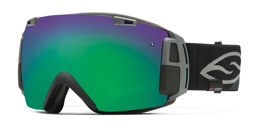
Sporting goods maker Smith Optics is offering I/O Recon goggles for winter sports enthusiasts, which combine Smith’s premium anti-fog lenses with GPS and Bluetooth technology. A heads-up display is integrated into the frame design, allowing users to log and view information without taking their eyes off the powder.
According to Smith Optics, the frame design maximizes field of view. With the heads up display, skiiers and snowboarders can see the speed they’re going, the height of their jumps, and track and follow their friends on the slopes. The Bluetooth allows connection to a smartphone.
Verizon will soon be offering Verizon Vehicle to U.S. consumers. The new connected-vehicle service aims to modernize traditional roadside assistance offerings while enhancing driver safety, convenience and savings, according to Verizon. Verizon made the announcement today at the North American International Auto Show in Detroit.
Verizon Vehicle is expected to make its commercial debut in the second quarter of 2015. With Verizon Vehicle, drivers will have easy access to diagnostic technology, live assistance, and roadside assistance with GPS accuracy. The service can connects drivers to live A.S.E. certified mechanics to diagnose potential problems and offer solutions. If drivers need assistance, the built-in GPS identifies their exact location, and a tow truck driver or other help can be dispatched as needed, with precision.
Erik Goldman, president of Verizon Telematics, explained that more than 200 million U.S. vehicles lack connected capabilities, vehicles that could benefit from the new service.
“As one of the largest communications companies in the world, we are dedicated to providing consumers with innovative technology solutions that connect people, solve challenges and inspire change,” Goldman said. “Verizon Vehicle is a unique and truly holistic aftermarket solution available to over 200 million vehicles on the road today. It affords millions of drivers the power of knowing when things aren’t working well, potentially before a breakdown occurs — fostering a safer, smarter and more economical way to drive and maintain a vehicle. And while even the best technology can’t prevent every breakdown, the service modernizes the traditional roadside assistance offerings which, for the most part, haven’t been updated in 50 years.”
Verizon Vehicle is powered by the Verizon Wireless network and is compatible with nearly every vehicle made and sold in the U.S. since 1996 — more than 9,000 makes and models. Verizon Vehicle will launch as a subscription-based service available to drivers regardless of the wireless service provider they use for their mobile devices. Members also receive discounts on travel including hotels and auto services.
The service operates through an OBD reader that can be self-installed in the under-dash diagnostic port, a Bluetooth-enabled speaker attached to the visor and a smartphone app. Members can choose to use the app or elect to set up the service to contact them — by phone, text, push notification or email — if a potential issue is detected with their vehicle. The speaker offers one-button push connection to the member care group, the mechanics hotline and roadside assistance, as well as a second button for SOS emergency situations.
The subscription-based service will include:
GPS-directed pinpoint Roadside Assistance for breakdowns, flat tires, overheating, a dead battery — anything that might require towing or immediate repair. Dispatches are made to the exact location of a disabled vehicle.
Automatic Urgent Incident AlertSystem places a call to the Verizon Vehicle Member Care Center in the event of a suspected accident. Help is immediately dispatched to the location if an accident is confirmed or there is no response from the driver. The time saved can potentially save lives by delivering critical emergency assistance when a person may not be able to call for help.
One-Button SOS Assistance immediately connects the driver to a live agent for emergency aid.
Auto Health System with Predictive Diagnostics translates most “check engine” light occurrences into real terms, including the description and severity of the matter, the probable solutions for the problem — and the appropriate cost for the repairs. The system is also designed to provide early warnings relating to some vehicle functions, even before a warning light comes on, to help keep you off the side of the road.
Mechanic’s Hotline is staffed with A.S.E. Certified Mechanics providing members access to immediate and unbiased information related to their vehicles, and a professional analysis of trouble they may be experiencing.
Parking & Meter Tools help drivers find where they left their vehicle —using the Verizon Vehicle smartphone app — while also keeping track of how much time is left on the meter.
Maintenance Alerts inform vehicle owners when scheduled maintenance is required. No more guesswork as to when to rotate those tires or change the oil.
Stolen Vehicle Location Assistance guides drivers when reporting a theft and helps authorities recover the stolen vehicle.
Travel & Repair Savings — Verizon Vehicle members will be entitled to discounts on hotels, vehicle rentals, auto maintenance, repairs and related travel expenses.
The service is expected to launch nationally this spring with availability thru nationwide retailers late in 2015. Advance consumer orders for the service are being accepted at VerizonVehicle.com and at 800-711-5800.
Report on the 14th meeting of the National Space-based PNT Advisory Board in Washington, D.C., held December 10-11, 2014.
By Ron Hatch
Ron Hatch
The December meeting of the PNT Advisory Board meeting brought forth important developments and proposals for the protection of GPS as part of the U.S. critical national infrastructure. A separate presentation made by speakers from the National Telecommunications and Information Administration (NTIA) and the Federal Communications Commission (FCC), concerning possible limitations on the use of signals from other GNSS, generated some controversy, alarm, and extensive follow-on discussion by industry, users, and other concerned parties.
Critical Infrastructure. Perhaps the most important presentation was that of Brad Parkinson, the acting chair, in his recap of the recommendations to be made by the Advisory Board to the PNT EXCOM.
The first recommendation was a reiteration of the Advisory Board opinion that the GPS be designated as one of the “critical infrastructures” of the United States. This opinion was based upon the fact that 14 of the existing designated critical infrastructures involves the use of GPS. The feeling was that such a designation would enhance the attention focused upon ensuring GPS reliability.
A second recommendation was that a comprehensive threat assessment to GPS operation be generated that can be used to assess its vulnerabilities. The remaining recommendations to the EXCOM were based upon the results of studies by the two working groups that were presented next.
The two working groups of the advisory board, specifically the “Assured Availability” and the “Economic Value of PNT” working groups, gave the next set of presentations. The Assured Availability working group was split into three sub-groups. The three aspects addressed were to “Protect,” “Toughen,” and “Augment.” The Protect working group recommended action to encourage the reversal of European initiatives to authorize pseudolites that broadcast within the GNSS L1 frequency band. Since such pseudolites would constitute authorized interference to standard GNSS receivers, it was recommended that our State Department encourage a reconsideration of the pseudolite proposals and that they be constrained to operate on a frequency outside the L1 frequency band.
The Toughen working group looked at a number of measures by which GNSS receivers could be improved to better withstand intentional and unintentional interference. Phased array antennas, inertial aiding and various software tracking improvements were discussed. An invited presentation by Gary McGraw of Rockwell addressed some of these issues particularly from a military perspective. An additional invited presentation upon the requirements for precise time-keeping in trading of financial transactions was presented by Andrew Bach.
The Augment working group discussed a number of ways in which the GNSS capabilities could be augmented. Prior recommendations that eLoran should be maintained as a backup was again strongly recommended. In addition, the ability to track other GNSS satellites in addition to GPS satellites was encouraged, even though it was recommended that special precautions and automated checks needed to be implemented in the light of the system failures that have been noted with the GLONASS satellites. A very interesting invited presentation by Robert Lutwak of the Defense Advanced Research Projects Agency (DARPA) described the continuing progress toward higher precision inertial sensors.
The second working group, the Economic Value of PNT, reported on firmed up plans to strengthen the existing studies of the economic value of PNT by engaging the economists resident within the various cabinet departments within the EXCOM to which the Advisory Board reports. The detailed plans were given in a presentation by Irv Leveson that outlined the plans for “A Comprehensive Quantitative Economic Assessment of GPS.”
It is not my intention to slight any of the other presentations, but I felt two of the remaining presentations were very important. Specifically, the presentation by Karen Van Dyke on Department of Transportation plans regarding “Adjacent L-Band Compatibility and GPS Signal Monitoring” was very encouraging. Among other items, it indicates that adjacent band-power limits will be carefully analyzed and tested to ensure that all existing applications of GPS will not be harmed.
FCC on International Signal Use. The second presentation that I felt was very important was by Paige Atkins of the National Telecommunications and Information Administration (NTIA) and Ronald Repasi of the Federal Communications Commission (FCC). Their presentation was titled “NTIA/FCC Spectrum Management Perspectives.” The presentation covered the background and intent of the various authorizing legislation. There were, however, some disturbing comments made.
Specifically, the item on the slide about National Space Policy that had a major bullet: “Guidance to all departments and agencies – ‘maintain and enchance’ space-based PNT systems. To this end the U.S. shall (among other things)…” There were two sub-bullets.
The first addressed GPS protection as a critical infrastructure component. The second sub-bullet stated “Foreign PNT services ‘may be used to augment and strengthen the resiliency of GPS.’” The verbal transcript is not yet available, but it seemed to me that Ron Repasi minimized this statement by indicating that resilience was subject to interpretation.
The real alarm was in his following comments during the question-and-answer discussion, where he indicated that the use of GLONASS within U.S.-based receivers was not authorized and that, therefore, the frequency band they used was not necessarily subject to protection. In addition, it was indicated that three years ago, procedures were developed whereby one could apply for authorization to the use the GLONASS signals. To date, Ron Reposi indicated that no organization had applied for authorization to use GLONASS, and that therefore it was currently illegal to use it.
Significant discussion was generated by the above, both following the presentation and the next day in a recap. From the discussion, it appears that a March 2011 regulation outlining the requirements for authorization of receiving “Earth stations” is being interpreted by the FCC as requirements for authorization of GLONASS receivers.
[Editor’s note: The process for securing a waiver of FCC regulations requiring authorization to receive international RNSS satellite signals was identified in an FCC Public Notice released in 2011. This process is initiated by National RNSS System providers, which have the satellite information needed to secure a waiver. Members of the GPS Innovation Alliance (GPSIA, www.gpsalliance.org, formerly the U.S. GPS Industry Council) have stated that they remain fully committed to producing multi-GNSS signal user equipment consistent with U.S. policy, and to working with the FCC and NTIA in considering these requests.]
In light of the multitude of GLONASS receivers already in use, including a number of U.S. government and agency receivers, the discussion was primarily on what should be done next. The decision taken was not to panic, but to bring the problem to the attention of the various government departments represented on the EXCOM and proceed with some caution.
The possibility was raised that NASA, in conjunction with the State Department and other interested parties, could seek a blanket authorization to use GLONASS within GPS receivers. This was discussed and presented as a possible way forward. Clearly, the issue is one that will be followed with great interest.
Proteus FZC, a provider of satellite-derived mapping and classification services, is now offering a daily water quality monitoring service for the Arabian Gulf. Derived from NASA satellite data, the new service provides daily online access to reports on six water quality parameters at 250-meter to 1-kilometer spatial resolution.
“We can further improve the accuracy of the standard NASA data by calibrating each data set to local water conditions,” said Proteus CEO David Critchley. “The easy-to-read reports are available online or can be delivered in PDF formats via email.”
Proteus now offers the daily service for organizations responsible for monitoring and maintaining the condition of coastal and offshore waters — environmental agencies, energy producers, desalination operators, marine engineering firms, and dredging companies.
“If an offshore infrastructure construction project is responsible for excessive water turbidity, the engineering company has to remediate the problem quickly,” Critchley said. “Likewise, desalination and power plants need to take precautionary actions if too much suspended sediment or sudden algal blooms are spotted near their operations.”
The daily water quality reports are derived from processed data collected by the MODIS (Moderate Resolution Imaging Spectroradiometer) sensors which fly aboard the orbiting NASA Terra and Aqua satellites.
“The sensors typically provide water quality details to a depth of three meters, depending on water column clarity,” said Critchley
The daily water quality reports provide the following information:
Total suspended sediments (mg/L) at 250-meter resolution
Chlorophyll-a content (mg/m3) at 1-km resolution
Sea surface temperature (degrees C) at 1-km resolution
Turbidity or fluorescence line height (mW/cm2/µm/sr) at 1-km resolution
Diffuse attenuation coefficient (m-1 at 490 nm) at 1-km resolution
True color composite (image) at 250-meter resolution
The 250-meter resolution is suitable for marine monitoring because it enables data collection for the entire gulf region several times per day. When the regional 250-meter resolution MODIS-derived product reveals a water quality anomaly or if increased spatial detail is required, Proteus water quality customers have the option of requesting higher resolution reports processed from other satellites that can map events in more detail.
“We will soon expand the daily water quality monitoring service to ice-free oceans, seas and large lakes worldwide,” Critchley said.