Concerns raised about cascaded Kalman filters for loose coupling and/or usage of input data “massaged” in unknown ways are not new, but are routinely excused by requirements to use coordinates from receivers not providing measurement outputs. Often, however, a receiver’s internal 8-state extended Kalman filter (EKF) is not fed with precise carrier phase data — and even when it is, its velocity outputs (being both filtered and unaided) have limited ability to follow high dynamics. Velocity pseudomeasurements under those conditions interfere with IMU aiding.
The extent of reduction in capability of course depends upon the equipment (widely varying and beyond reach of the user) and upon the scenario. Not only flight paths but any trajectory with sharp changes in speed or direction are affected. Twisting, jerking, and winding motions actually experienced can be reported as having reduced severity, and attitude history will suffer further inaccuracy. A demand to accommodate loose coupling is then best satisfied by pseudomeasurements in position only.
This is not an attempt to coax an entire industry into abandoning a very popular choice for satnav/inertial measurement unit (IMU) integration. By “what’s wrong with it” I mean how it’s often done. Believe it or not, there’s a fundamental self-defeating trait in current practice.
Admittedly, I gave short-shrift to loose coupling in my 2007 book GNSS Aided Navigation & Tracking; all flight data processing results in it were for tight coupling with carrier phase (actually, 1-second changes in phase) included. Some years ago, though, I reran segments from that flight, including takeoff and another segment containing a 180-degree turn, with only latitude/longitude/altitude (LLH) pseudomeasurements and no carrier-phase information. Not surprisingly, it provided accuracy commensurate with quality of the LLH input (how could it not?). With heading info added, the velocity errors (peak transients of a few meters/second near start and end of the turn; otherwise smaller) and leveling accuracies (a few mrad) were likewise commensurate with input quality.
I never bothered to publish that; the world doesn’t need more testimony for ability to convey data obtained from a receiver with satellite visibility favorable throughout.
I avoided, however, using pseudomeasurements of velocity. Precisely therein lies the target of this critique: velocity from a receiver’s internal 8-state EKF, fed only from position-dependent measurements in the form of pseudoranges. More broadly, this focuses attention on receivers wherein carrier-based information is either unused (immediately below), imprecise (for example, by using deltarange or cutting corners in other ways), or filtered (thus correcting with averaged past, rather than near-instantaneous, derivative data).
First, velocity observables derived exclusively from the same inputs providing position create a glaring violation of independence — but there’s also a bigger issue: Velocity pseudomeasurements with that scheme constitute a basic contradiction of inertial aiding. A main purpose of the IMU is to reveal dynamics with promptness that data derived from pseudorange histories can’t match. Allow me to review some fundamentals here.
At UCLA more than a half-century ago, I taught undergraduate lab experiments. One illustrated under-/over-/critically damped response, a concept so familiar that no math is needed to explain it. Any application will suffice; that experiment involved control of a motor shaft position. A simple transfer function applied to the position feedback signal determined the damping. With all feedback derived from position, either critical or slight underdamping was de rigeur.
Addition of rate aiding (for that experiment, a tachometer) dramatically improved response without degrading accuracy. The obvious reason: it was no longer a choice between responsiveness versus accuracy. Both are available when an independent rate sensor accompanies the position indicator.
Now, consider redesigning that controller’s rate portion of the feedback signal, giving dominance to sequential changes in position. Unless both highly precise and independent, that would curtail the benefit (that is, improved response to dynamic change) of adding measured rate. Degradation would also arise from giving dominance to a more crudely approximate and/or heavily filtered indication of rate.
There are differences between that example and satnav/IMU integration (for example, estimation versus control; time-varying versus constant gains; and so on) but the principle remains applicable. When derived rate from that 8-state Kalman filter is used to correct (thus overrule) the velocity history, the responsiveness to dynamics offered by the IMU is being undermined by a process that’s beyond reach. The system’s position and velocity then draws nearer to the output of an unaided (standalone) receiver.
The practice raises various questions:
Is that an integrated approach worthy of the name? Or doesn’t the IMU just derive attitude adjustments by riding piggy-back — thereby taking (velocity history from an unaided receiver) without giving (unimpeded improvements in response to dynamics, as expected from inertial aiding)?
How good is that system’s accuracy (not in position; in velocity and in leveling — and not from simulation; from flight data with dynamics)?
If LLH data were replaced by pseudoranges for tight integration, would velocity pseudomeasurements still be used, to give coupling tight for position but loose for velocity?
(I hope not.)
Since velocity pseudomeasurements are unnecessary in tight integration without carrier phase data, then why use them with LLH?
I’ll turn that last item into a recommendation for satnav/IMU suppliers hoping to compete successfully: If you must include a loosely coupled mode to accommodate LLH-cum-velocity data from a receiver’s 8-state EKF, don’t use receiver velocities as observables. Your system outputs will evolve without them.
Appropriate design is required (you’ll have to do more than just disconnect the velocity inputs) but, given that, all information will be extracted from the IMU and LLH data — with inertial aiding in high dynamics unobstructed by superfluous (8-state-derived) velocity data. Accuracy will improve in not only velocity but also attitude — from simpler software.
An objection might be raised, noting fair performance when exploiting the full 8-state information if dynamics are always mild. To that I would answer: Is there no limit to how much performance will be sacrificed just to accommodate expediency? Loose coupling already forfeits robustness. Let’s not compound that by surrendering dynamics as well. All of us realize the large, and growing, array of obstacles disrupting successful operation. Why design only for benign conditions? Approaches taking advantage of advances beyond exploiting separate pseudoranges (usage of precise carrier phase, ultratight coupling, FFT-based deep integration) remain ever more in the minority, despite myriad threats to GNSS.
This discussion has concentrated on unnecessary limitations of loosely coupled GNSS/INS integration performance as commonly practiced. Similar problems in systems with tighter integration are less prevalent but still not uncommon (for example, inertial instrument error modeling is still not widely understood, and attitude accuracy reported from many sources doesn’t reach achievable levels. Those familiar with my writings are aware of various changes I would advocate, not limited to inertial or satellite navigation. Those and other issues will be left to another time.
James L. Farrell worked for 31 years at Westinghouse in design, simulation, and validation of navigation and tracking programs. He teaches and consults for private industry, the Department of Defense, and university research through Vigil, Inc.
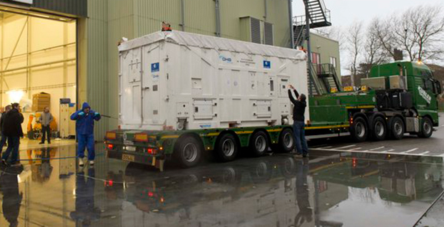
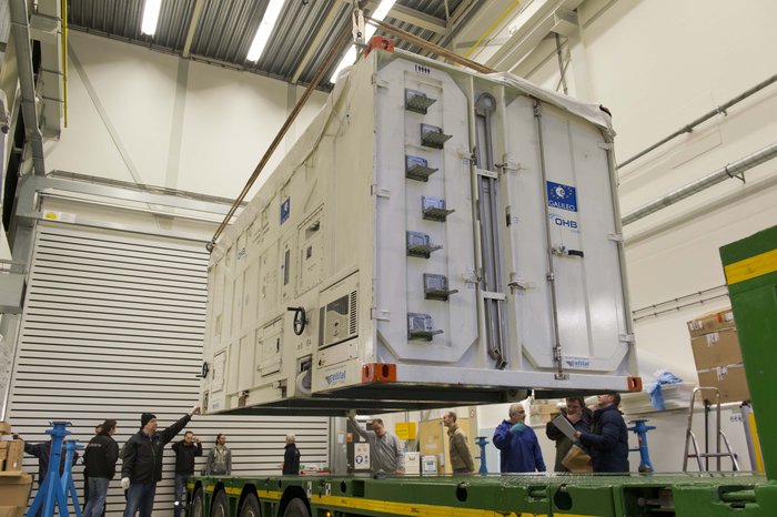
The latest Galileo satellite, formally known as FOC FM06, arrived at the ESTEC Test Centre in its protective container on Dec. 18, after traveling from OHB in Bremen, Germany. Photo: European Space Agency
The latest Galileo satellite has arrived at ESTEC, in the Netherlands, and is undergoing a full checkout to prove its readiness for space.
The satellite was carried by lorry from its manufacturer in Germany, cocooned within an environmentally controlled container. It arrived inside ESTEC’s cleanroom environment on Dec. 18. The container was then opened up to begin preparations for testing.
The first six Galileo satellites are already in orbit, launched in pairs in 2011, 2012 and August this year.
The last pair was delivered into the wrong orbit by a faulty upper stage, but the fifth satellite’s orbit has since been changed to allow checking of its navigation payload, which began at the end of November.
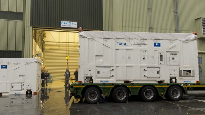
The sides and top of the Galileo satellite container were sprayed clean before it was taken inside the bay of the ESTEC Test Centre to keep any contamination from entering the pristine cleanroom. Photo: European Space Agency
Meanwhile, down on the ground, production of further satellites continues steadily, taking the Galileo series into double figures overall.
Following on from the first four In-Orbit Validation satellites, 22 of these Full Operational Capability satellites are being built by OHB in Bremen, Germany, with navigation payloads from SSTL in Guildford, UK.
Numbered Flight Model 6, or FM06 for short, this latest of the newer satellites is now reunited under the test centre’s roof with three others. FM03 and FM04 have completed their acceptance testing, culminating in the weeks-long thermal-vacuum test. Each satellite was subjected to the same vacuum and extreme temperature conditions experienced in orbit, as well as radio-frequency testing of their navigation payloads and antennas inside an anechoic chamber isolated from the external universe. This pair is now in storage in the centre pending the results of their concluding acceptance review.
The other satellite, FM05, recently ended its own thermal-vacuum trial. It is now being reconfigured for radio-frequency testing, planned to take place after the Christmas break. The latest unboxed Galileo satellite will undergo its own thermal–vacuum test in January.
ESTEC is an essential stop on the way to space for Galileo. It is equipped with all the facilities needed to simulate space conditions under a single roof, including an acoustic chamber, earthquake-strength shaker tables, and anechoic and vacuum chambers, along with a range of specialised measuring equipment.
Once ESTEC gives the satellites its stamp of quality then they are in principle ready to be flown to Europe’s Spaceport in Kourou, French Guiana. ESA and the European Commission are currently deciding on the launch schedule for these next Galileos.
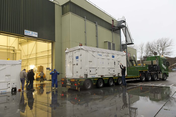
The container containing the latest Galileo satellite, FOC FM06, was carefully hoisted off the lorry that carried it from OHB in Bremen, Germany. Its underside was then carefully cleaned before it was taken out of the bay into the cleanroom environment. Photo: European Space Agency
Satellite TV pirates beware: Broadcom Corporation is offering a GPS-enabled satellite outdoor unit (ODU) device that gives satellite TV providers a way to track subscriber equipment, pinpoint service issues in the home, and stop piracy with a geo-lock. The solution will also enable delivery of location-based services.
The ODU solution combines Broadcom’s BCM4551 satellite TV device with its BCM4771 GPS receiver.
Broadcom’s new satellite solution resides in the low-noise block (LNB) of a subscribers’ satellite dish, enabling operators to better position dish installations and reduce metering equipment costs and truck rolls. Combining GPS-enabled ODU technology with a set-top box, operators can quickly locate and validate a subscriber’s home location, Broadcom said.
“By combining Broadcom’s field-proven satellite ODU technology with GPS functionality, we are able to provide operators with the capability to more conveniently and cost-effectively track the location of their equipment and prevent redistribution of content to nonsubscribers,” said Nicholas Dunn, Broadcom vice president of Direct Broadcast Satellite Marketing. “This integrated technology can also open the door to operator delivery of location-based social media and business applications, providing subscribers with targeted content such as information on local service providers, retail operations and restaurants, or a specific televised event.”
GPS technology within the LNB also allows operators to geo-lock content to subscribers. Content geo-locking uses a subscriber’s location to deliver video content specific to the subscriber’s service address. This ensures the delivery of personalized services and prevents costly theft of service for operators. Previously, content geo-locking was only available through a costly external device attached to subscriber’s set-top box; today’s introduction from Broadcom offers best-in-class capabilities at an incremental cost for operators.
Key Features of the BCM4551
Highly-integrated 28 nanometer (nm) process with low power consumption
Allows 24 DVB-S2 channels to be stacked on a single coaxial cable to service any STB to reduce satellite operator installation costs
8 RF inputs and 1RF output covering the 250 to 2350 MHz frequency range
24 user-band output channels
24 output channels selectable from any LNB input
Frequency shift keying (FSK) and digital satellite equipment control (DiSEqC)
Key Features of the BCM4771
Highly integrated radio frequency (RF), baseband processor and CPU with smallest complete PCB footprint
Faster signal searches, accurate real-time navigation and improved tracking sensitivity
Increased satellite availability: supports GPS, and GLONASS satellites at L1 frequency band.
Broadcom will demonstrate the new solution at the International CES show, January 6-9.
The General Assembly of the European Geosciences Union will feature a high-precision GNSS session, and is seeking paper submissions. The EGU General Assembly will be held in Vienna, Austria, April 12-17, 2015.
The conference will bring together geoscientists from all over the world to one meeting covering all disciplines of the Earth, planetary and space sciences. The EGU aims to provide a forum where scientists, especially early career researchers, can present their work and discuss their ideas with experts in all fields of geoscience.
Deadline for receipt of abstracts is January 7. To submit an abstract, visit the website.
Session G1.3 description: In the past two decades high-precision GPS has been applied to support numerous applications in geosciences. Currently, there are two fully operational Global Navigation Satellite Systems (GNSS), and two more are in the implementation stage. The new systems are about to start providing the user signals, and both, GPS and GLONASS are currently undergoing a significant modernization, which adds more capacity, more signals, better accuracy and interoperability, etc. This, however, also results in new challenges in data processing. Moreover, the new developments in GNSS stimulate a broad range of new applications.
Algorithmic advancements are needed to address the opportunities and challenges in enhancing the accuracy, availability, interoperability and integrity of high-precision GNSS applications.
This session is a forum to discuss new developments in high-precision GNSS algorithms and applications in geosciences. The organizers encourage submissions related to:
Modeling and strategies in high-precision GNSS
Multi-GNSS potential benefit for geosciences
Precise Point Positioning (PPP)
CORS services for geosciences (GBAS, Network-RTK, etc.)
Biases and calibrations
New or improved GNSS products for high-precision applications (orbits, clocks, etc.)
Ambiguity resolution and validation
Precise Positioning of EOS platforms
Precise Positioning for natural hazards prevention
High-precision applications for geosciences
Papers are welcome on all aspects of these issues.
Will Be Employable for Surveying, Precise Positioning, and Geodesy
By Peter Steigenberger and André Hauschild, German Aerospace Center (DLR) / German Space Operations Center
The first Full Operational Capability (FOC) Galileo satellite started transmitting L-band navigation signals on November 29, 2014. Based on data collected by a global network of GNSS tracking stations of the Cooperative Network for GNSS Observation (CONGO) and the Multi-GNSS Experiment (MGEX) of the International GNSS Service (IGS), we determined that an E1 signal with pseudorandom noise code (PRN) E18 was first tracked at the station LLAG (La Laguna, Tenerife, Canary Islands) at 06:08 UTC. A few moments later, the satellite’s transmissions were also tracked at other MGEX stations including the E5a, E5b, and E5 AltBOC signals. Based on the computed satellite visibility at various tracking stations, the satellite could be positively identified as GSAT0201, also known as Galileo FOC-FM1 or Galileo 5 with COSPAR ID 2014-050A and NORAD ID 40128.
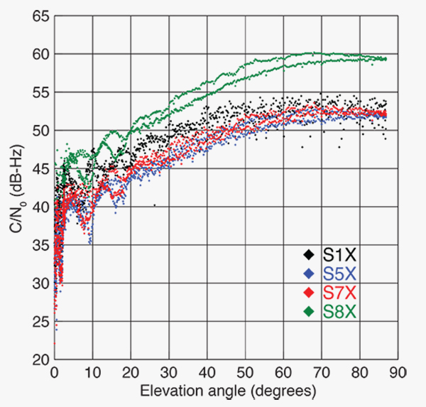
FIGURE 1 shows the carrier-to-noise-density ratio (C/N0) of the E18 signals tracked at the CONGO/MGEX station SIN1 (Singapore, using a Trimble NetR9 receiver with a Leica AR25.3 antenna). We selected the signals from this station for analysis due to an E18 pass occurring close to the zenith and covering almost the full range of elevation angles. The E5a and E5b signals (S5X and S7X RINEX identifiers) show very similar performance, whereas the C/N0 values of the E1 signal are 1–2 dB-Hz higher. The C/N0 values of the E5 AltBOC signal (S8X) reach 60 dB-Hz at high elevation angles, which is about 6 dB-Hz higher than the other signals.
Figure 1. Galileo E18 carrier-to-noise-density ratio for the CONGO/MGEX station SIN1 (Singapore).
The first pair of Galileo FOC spacecraft was launched on August 22 with a Soyuz launcher from the Guiana Space Centre, Kourou, French Guyana. Due to a malfunction of the Fregat upper stage, the satellites were injected into elliptical orbits with an inclination of about 49° instead of near circular orbits with 55° inclination. In November, the perigee of the first FOC satellite was raised by about 3,500 kilometers by a series of 11 maneuvers with a corresponding reduction in orbit eccentricity from 0.23 to 0.16.
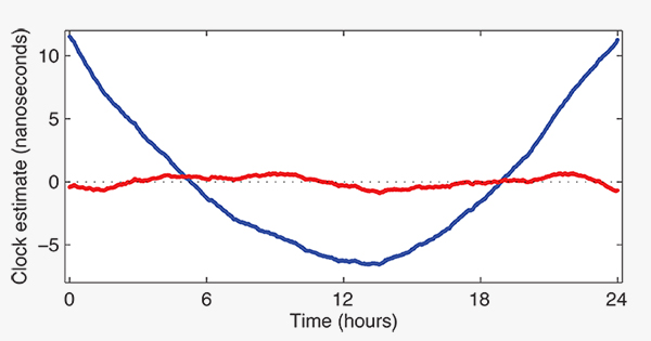
E18 has been included in the precise orbit and clock solutions of the MGEX analysis center at Technische Universität München (TUM) in Munich, Germany, since December 5. FIGURE 2 shows the detrended estimates of the active Galileo E18 clock for December 7. The presence of a pronounced quadratic term as well the large drift of 33.9 microseconds per day indicate that the active clock is a rubidium atomic frequency standard rather than a more precise passive hydrogen maser. The FOC satellites carry two of each kind of clock.
Figure 2. Galileo E18 clock estimates for December 7, 2014, with respect to the hydrogen maser at the Ottawa IGS station (NRC1) after removing an offset and drift (blue) or a second order polynomial (red).
The TUM orbit and clock product allows researchers to again compute dual-frequency positioning solutions using only Galileo observations, as the In-Orbit Validation satellite E20 has not transmitted an E5 signal since May, when a power anomaly left the satellite with the capability to only transmit an E1 signal. Furthermore, E20 currently does not transmit a navigation message.
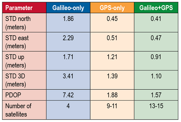
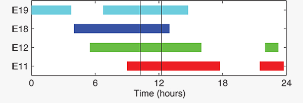
TABLE 1 shows the scatter of single-point positioning using pseudorange (code) observations from the MGEX station MAS1 (Maspalomas, Gran Canaria, Canary Islands) for a Galileo-only, a GPS-only, and a combined Galileo+GPS solution for December 6. At an elevation cut-off angle of 10°, four Galileo satellites were visible from 10:15 until 12:25 UTC (see FIGURE 3). The GPS-only solution covers the same time interval. The start time is not limited by the cut-off angle but an E18 transmission outage from 3:45–10:15 UTC.
TABLE 1. Single point positioning results for the MGEX station MAS1 (Maspalomas) for December 6, 2014.Figure 3. Galileo visibility at the MGEX station MAS1 (Maspalomas) on December 6, 2014. The time period considered in the single-point positioning is indicated by vertical lines.
We used an ionosphere-free linear combination of Galileo E1 and E5 AltBOC code observations and GPS L1 and L2 code observations with a 30-second sampling interval. As the Galileo-only solution suffered from position dilution of precision (PDOP) values of up to 830, a total of 32 epochs with PDOP values greater than 25 were excluded. The geometry of the remaining epochs is still pretty unfavorable. At a mean PDOP value of 7.4, the standalone position solution exhibits a 3D standard deviation (STD) error of 3.4 meters. Use of the Galileo satellites in a combined GPS+ Galileo solution improves the positioning performance. In particular, the height component benefits from the inclusion of the four Galileo satellites with a standard deviation improvement of 25 percent.
Despite the orbit injection error, the new Galileo FOC satellite has now been successfully activated and added to the Galileo constellation. Unfortunately, the current orbit is incompatible with the standard Galileo almanac format, which may cause restrictions for some commercial receiver types.
Nevertheless, the satellite can already be tracked by a wide range of geodetic receivers with existing firmware versions and it will, in fact, be possible to use the new satellite for diverse applications in surveying, precise positioning, and geodesy, as well as in general multi-GNSS studies. We now look forward to the activation of the second FOC satellite, which can be expected in early 2015 and will, for the first time, offer multi-frequency signals from a total of five Galileo satellites.
Sanctions Delay GLONASS-K2
According to Nikolai Testoyedov, the CEO of Information Satellite Systems Reshetnev, manufacturer of the GLONASS satellites, the company will now produce nine GLONASS-K1 satellites.
“For a smooth transition to a multi-functional group and due to issues with the very complex GLONASS-K2 satellites, we decided to continue with the GLONASS-K1 intermediate range of satellites, and we are preparing for the launch of nine units of this series,” he said.
He recalled the original plan was to launch two K1 satellites and then move to GLONASS-K2 satellites.
“In the beginning, really, we wanted after the two GLONASS-K1 satellites No. 11 and 12, to go for the launch of more advanced GLONASS-K2 devices. But, unfortunately, the plans had to be adjusted somewhat because of the sanctions restricting the delivery of radiation-resistant electronic components from the West. We have to put a hold on the in-depth development of technical and technological documentation and that delays us in terms of moving ahead by at least a year or two,”he said.
Reported by the Russian magazine Vestnik GLONASS, and relayed by Richard Langley’s CANSPACE listserv.
GNSS Mandates Would Violate Trade Agreements
A U.S. government representative stated at an international satnav forum that mandating use of specific GNSS services for applications such as air-traffic control, freight shipments, emergency calling, and road tolling could violate the terms of World Trade Organization (WTO) agreements that many nations, including all six GNSS providers, have signed.
Regional mandates already exist for GLONASS in Russia and BeiDou in China, and have been suggested and extensively discussed in Europe, as a way of stimulating the market adoption of Galileo receiver chipsets, thus recouping some of the massive public investment in the satnav system.
The presentation occurred during the Ninth Meeting of the International Committee on Global Navigation Satellite Systems (ICG), held Nov. 10–14, 2014, in Prague, Czech Republic.
Jason Kim, a senior policy analyst at the U.S. Department of Commerce, stated that the United States and the European Union already enjoy a productive dialog on GNSS trade issues under the 2004 U.S.-EU Agreement on GPS-Galileo Cooperation. In that agreement, both parties agreed to consult before establishing GNSS standards, certification requirements, regulations, mandates; affirmed their non-discriminatory approach with respect to GNSS trade; and established a working group to consider non-discrimination and other trade related issues.
Finally, the United States and the European Union recognized and reiterated in 2004 their commitments to WTO rules including those governing technical barriers to trade, specifically, that there would be no goods discrimination based on non-tariff measures such as regulations, standards, testing, or certification.
Kim made the remarks in the course of his presentation titled “GNSS Market Access.” He told GPS World that his presentation was directed less at the European Union, which has been conscientious of its WTO commitments, and more towards the rest of the ICG members, including non-provider nations that may be asked by GNSS providers to mandate specific systems.
“To promote adoption of their systems,” Kim stated, “GNSS providers are considering/implementing equipage mandates for various applications: aviation, motor-carrier and HAZMAT vehicle tracking, car accident reporting (eCall/ERA-GLONASS), and emergency phone calls (E112).
“The United States recommends technology-neutral, performance-based standards,” Kim continued, giving as example the U.S. E911 rules that specify a required positioning accuracy and then allow wireless carriers to choose the best technical solutions according to their lights.
The U.S. government presentation at ICG revealed particular concern that regulations under consideration could adversely affect the sales of U.S. GPS-enabled hardware in many industry sectors. All members of the WTO, including the six GNSS providers on the ICG, are bound to a range of trade agreements designed to promote open-market access, all cited in the Prague ICG presentation: the General Agreement on Tariffs and Trade (GATT), the Agreement on Technical Barriers to Trade (TBT), and the General Agreement on Trade in Services (GATS). The United States, Europe, Japan, and 12 others are also parties to the WTO Agreement on Government Procurement (GPA).
European Commission officials have publicly and recently stated that they are considering how to stimulate Galileo use, in particular through regulatory measures requiring that navigation equipment be installed on aircraft, automobiles, and other platforms.
“Requiring specific systems arbitrarily prevents or penalizes imports of goods having perfectly functional GNSS capability,” said Kim. “WTO members must comply with TBT obligations in setting technical regulations.”
He concluded his presentation by requesting that the ICG Providers’ Forum add GNSS market access to its future agenda for discussion, and consider developing a new principle on market access for future adoption.
We appear incompletely before you this month. A funny thing happened on the way to the presses: we discovered that we had more content than pages in which to squeeze it. “All the news that fits to print,” the motto of the New York Times, can in this instance not be ours. All the news just won’t fit!
First to feel the axe, lamentably, was Innovation, an article on the Python receiver; you will see it in February. Also pushed to the near future is reporting on the recent Stanford PNT Symposium; it appears in the December GNSS Design & Test e-newsletter, see the website if you don’t yet subscribe. Herewith, an ultra-brief account of a presentation by Greg Turetzky, Intel. The reporters identified this paper and one on BeiDou as “harbingers of change in the industry.”
The Turetzky paper, “Ubiquitous Location: Challenges and Opportunities ofEnabling All-day, Everywhere Location for All Mobile Platforms,” laid out the phenomenal growth of location-based services and the implications for design requirements in GNSS-wireless at the user device and silicon levels. The compound annual growth rate of GNSS devices will continue, from its current 22 percent level to a robust 9 percent for the years 2016–2022, and heading for seven billion installed units by 2022.
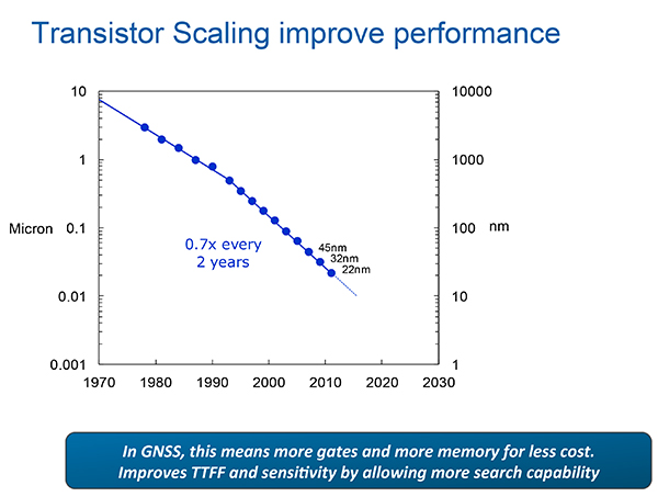
From Greg Turetzky’s Ubiquitous Location paper, presented at Stanford PNT Symposium.
Cutting to the chase, the design challenges for GNSS are to:
Take advantage of smaller geometries to achieve higher clock speeds, more memory, lower active power and smaller size, while reducing standby power from leakage;
Incorporate new methodologies in chip and system design; integrate multiple radios on a single die to reduce cost and size;
Integrate multiple radio sources into a single location solution;
Bring together a disparate value chain.
The technology roadmaps embrace most modalities of positioning: GNSS, Bluetooth, Wi-Fi, cellular, and SBAS, and cross most platforms, including wearables. “We think that another, unemphasized challenge,” reporters Litton and Langenstein note, “is in the increasing density of these units with the current specifications on out-of-band emissions and the spectrum sharing and spectrum management factors in the ubiquity of the devices.”
Tune in to our free webinar Receiver Design for the Future,with Greg Turetzky of Stanford speaking on Ubiquitous Location, scheduled for Jan. 15 (1 p.m. EST/ 10 a.m. PST/ 6 p.m. GMT). Register today!
By Ugo Celestino, European Commission, Antonella Di Fazio, Telespazio SpA, Vicente José Giner Herrera, Ineco, Patrizio Vanni, ENAV SpA, and Francisco Javier Deblas, ESSP.
This article describes a live demonstration of an aviation application in Tunisia, to help the local aviation community in validating the use of the European Geostationary Navigation Overlay Service (EGNOS) to guide airplanes during landing operations. This activity constitutes the first complete experience of EGNOS Safety of Life (SoL) service for aviation approaches outside Europe. We present here the obtained results that are useful not only for Tunisia, but as a valuable case study for other countries outside Europe interested in using EGNOS in aviation.
EGNOS, operational since 2009, has a European regional coverage that could be quite easily extended to areas adjacent to European Union through the deployment of limited additional ground infrastructure elements, but sharing the same existing space segment and leveraging the other core ground infrastructure.
The European Commission has put in place a series of actions since 2006 to support the EGNOS service extension in neighbouring areas. The MEDiterranean follow-Up for EGNOS Adoption (MEDUSA) is an on-going European initiative related to EGNOS extension in the Euromed region, including North African and Middle East countries around the Mediterranean basin: Algeria, Egypt, Israel, Jordan, Lebanon, Libya, Morocco, Palestine, Syria, and Tunisia. MEDUSA runs a program of technical assistance action in these Euromed countries, in order to prepare them for an optimal adoption and exploitation of European GNSS services in their priority market segments.
The Mediterranean Extension of EGNOS
EGNOS is Europe’s first venture into satellite navigation and paves the way for Galileo, Europe’s independent global satellite navigation system currently under deployment.
EGNOS is a satellite-based augmentation system (SBAS), whose signal is compliant to the international SBAS interoperability standards: standards – MOPS (Minimum Operational Performance Standards) and ICAO SARPs (International Civil Aviation Organization Standard and Recommended Practices). In its current version (V2) it augments the open public service offered by the American Global Positioning System (GPS), by providing correction data that enables to improve GPS position accuracy, and provides integrity information about the GPS system (integrity information is fundamental for aeronautical applications like approaches). EGNOS is interoperable with the other equivalent regional systems. Today other SBASs are the U.S Wide Area Augmentation System (WAAS), the Japanese Multi-functional Satellite Augmentation System (MSAS), the Indian GPS Aided Geo Augmented Navigation (GAGAN) and the Russian System for Differential Correction and Monitoring (SDCM). The future version (V3) of EGNOS will augment Galileo signal as well.
Today EGNOS is operational, and available for use in aviation since 2011, giving opportunities for users to have more accurate and reliable positioning for enhancing existing applications, developing new applications and particularly the safety critical ones. Already more than 150 landing procedures are operational across Europe (some of them also in countries out of the European Union, such as Switzerland, Norway, Guernsey), with many others under development to reach 100 percent Approaches with Vertical Guidance (APV) coverage in the European instrumental runways as per ICAO recommendation.
EGNOS provides three services:
EGNOS Open Service (OS), launched in 2009, is delivered free of charge. It is open for use to anyone with an EGNOS-enabled receiver. This can be any receiver compatible with satellite-based augmentation systems. Being based on GPS, the EGNOS signal does not require major changes for receivers. Today, many mass market receivers available on the market are also EGNOS enabled. EGNOS OS is particularly suitable for mass market and some applications like surveying.
EGNOS Safety-of-life Service (SoL) is authorized for European civil aviation and operational since March 2011. EGNOS SoL delivers the integrity message providing the verification of the GPS system and timely warnings (within six seconds), when the system or its data should not be used for navigation. Since integrity relates to the trust that can be placed in the correctness of the location information supplied by GPS, thanks to this feature EGNOS is able to meet the demands of safety-critical applications in sectors such as aviation.
EGNOS Data Access Service (EDAS) launched in 2012, delivers a terrestrial commercial data service. It consists of a server that gets the data directly from EGNOS system and disseminates it via terrestrial networks in real time, within guaranteed maximum delay, security and performance. EDAS is particularly suitable for professional applications. It provides EGNOS raw data and corrections enabling software solutions that implement products and value added services built on them.
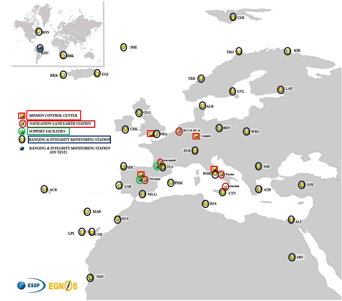
EGNOS infrastructure consists of three geostationary satellites over Europe and a network of ground stations (Ranging and Integrity Monitoring Station – RIMS) located to provide services whose coverage includes southern Europe, North Africa and some Middle East countries.
The EGNOS RIMS network supports a flexible network geometry that gradually adapts to service coverage requirements evolution. From the originally envisaged coverage over European Union’s countries, the EGNOS RIMS network is being expanded over Europe’s neighbouring areas, thus increasing the number of beneficiary countries. EGNOS SoL service is highly sought by several non-EU countries for the benefits it can bring to their civil aviation, in providing a solution to comply with ICAO requirements for Performance Based Navigation (PBN).
The present layout of the EGNOS RIMS network is presented in Figure 1.
Figure 1. EGNOS ground segment.
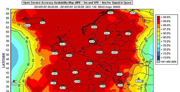
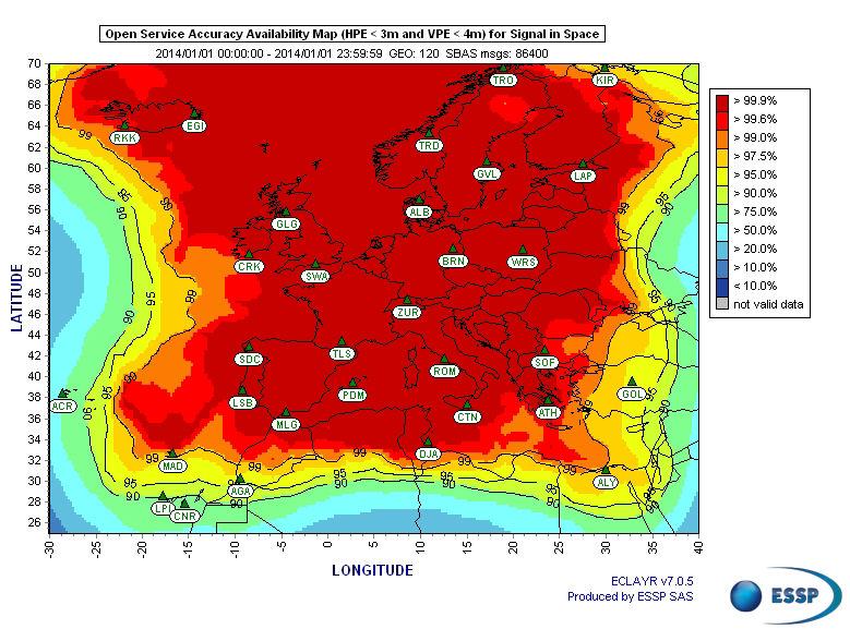
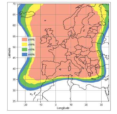
Figures 2 and 3 show respectively today’s coverage of EGNOS OS availability (source: European Satellite Services Provider, the service provider of EGNOS) and the APV-I availability performance commitment provided by EGNOS SoL (source: EGNOS Safety of Life Service Definition Document, EGN-SDD SoL, V2.0, European Commission, 2013), obtained relying on the above presented ground segment.
Figure 2. EGNOS OS Availability.
EGNOS OS Availability. The Figure 2 map is obtained by projecting the error at pseudorange level into the position domain. The computed error assumes that the GPS satellites used are those with an elevation angle above the local horizon (with a mask angle of 5º) and does not consider any possible factor depending on local characteristics that could produce different results (optimistic or pessimistic) with respect to the results computed using real receivers located in the considered areas. Moreover, it represents an estimation of EGNOS OS availability during a very limited period of time being an estimation, thus it does not imply any commitment or reference for the performances which can be obtained during different periods.
Figure 3. EGNOS APV-I Availability.
Other initiatives for a further extension in North Africa and Middle East are already being developed, under the umbrella of the Euromed GNSS programme. In parallel with the infrastructure deployment, the Euromed GNSS programme also includes actions to support the introduction and exploitation of EGNOS services. The first stage was completed in the frame of the Euromed GNSS I/MEdiTerranean Introduction of GNSS Services (METIS) project in the period 2006-2009, the second stage is presently running in the frame of the Euromed GNSS II/MEDUSA project. Further initiatives are being planned for 2015 and beyond.
EGNOS Use in Aviation
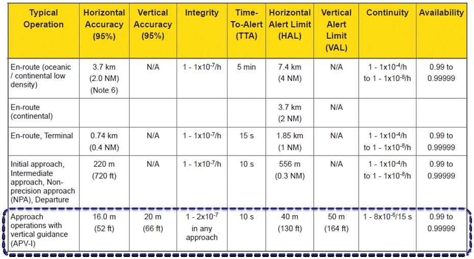
EGNOS was initially designed and developed to be used in aviation, similarly to the U.S. Federal Aviation Administration WAAS, to support different types of aviation applications and, in particular, to meet the performance requirements set by the International Civil Aviation Organization (Annex 10) for the implementation of APV-I, which enable the implementation of LPV final approaches, as reported in Table 1.
Table 1. ICAO Operational Requirements.
EGNOS is one of the GNSS elements recognised by ICAO (Annex 10) as a radionavigation aid. It is an important element of a global SBAS systems mosaic, that started with the American system WAAS in 2003, and that is gradually completed by other more recent SBAS: EGNOS itself, MSAS (Japan), GAGAN (India), SDCM (Russia), and some countries like Australia and South Korea that have launched feasibility studies to develop their own SBAS.
It is expected that, in a not too far future, most parts of the world will profit from SBAS services, following the current coverage extension plans and SBAS system evolutions. The final objective, as also shared at ICAO level, is that as many airdromes worldwide, as possible, can offer instrument approaches with vertical guidance, with an outstanding increase in global safety rates.
Additionally, the use of EGNOS allows taking full advantage of GNSS for all phases of flight, including final approach. Therefore, EGNOS means for aviation a fundamental and strategic tool to help meet ICAO’s recommendations, aimed at the adoption of a PBN oriented airspace use policy, for all countries. The 37th Assembly of ICAO (28 September – 8 October 2010) resolved that APV procedures should be implemented as either a primary or backup strategy for precision approaches at all instrument runway ends by 2016.
APV is a major safety initiative. ICAO recognises SBAS and Barometric Vertical Navigation (Baro-VNAV) as the two acceptable (and often complementary) means of implementing APV procedures, which are safer than NPA (Non Precision Approach).
GNSS based navigation enables RNAV (aRea NAVigation) with a higher cost effectiveness in comparison with the old conventional, sensor ground-based, navigation procedures. This is especially true for wide, even desert unequipped areas (or difficult to maintain) like those in North Africa and Middle East.
EGNOS benefits are maximized in final approach manoeuvres, providing GNSS lateral and vertical guidance, and enabling APV-I approaches.
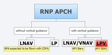
Final approach procedures based on GNSS are classified as RNP approaches (RNP APCH, as shown in the next figure), namely: Lateral Navigation (LNAV) with GPS lateral guidance and no vertical guidance; LP with GPS + SBAS (EGNOS) for lateral guidance (CAT-I localizer performance) and no vertical guidance; Lateral Navigation/Vertical Navigation (LNAV/VNAV) with GPS lateral guidance and Baro-Vertical Navigation (VNAV) vertical guidance (Baro-VNAV approach procedures can be flown with SBAS vertical guidance upon the approval of the Air Navigation Service Provider (ANSP)) and the LPV (Localizer Performance with Vertical Guidance) with GPS + EGNOS for both lateral and vertical guidance.
Figure 4. RNP approaches.
Those procedures not including vertical guidance are intended to be flown with the Constant Descent Final Approach (CDFA) technique (to avoid dangerous dive and drive practices), supported by most Flight Management Systems (FMS).
Regarding the operational LPV main figures, the European regulation (EU OPS -REGULATION (EC) No 859/2008 usually known as EU OPS) allows LPV operational minima (Decision Height – DH) down to 250 ft, expected to be possibly lowered down to 200 ft by 2015 (LPV-200), similarly to what is already permitted by the FAA, in the United Sates for WAAS based LPV approaches (a DH of 200 ft would make LPV approaches very competitive, when benchmarked against ILS CAT-I, precision approach, or even Ground Based Augmentation System (GBAS) CAT-I precision approach).
In the last few years, about 150 LPV procedures (status as of July 2014) have been published in European airports, and the number of procedures and countries introducing EGNOS is continuously increasing.
Euromed GNSS I/METIS and Euromed GNSS II/MEDUSA
In parallel with the development of the infrastructures necessary for extending EGNOS availability across the Euromed region, the European Commission has put in place initiatives to prepare and assist the Euromed countries for the optimal use and adoption of the relevant services.
These consist in two sequential projects, the first being Euromed GNSS I/METIS project and the second being Euromed GNSS II /MEDUSA.
Running from mid 2006 up to the end of 2009, METIS acted as a pioneer in the Euromed countries and built national/regional liaisons with decision-makers and key stakeholders, interested in sharing experience and absorbing know-how. The project assisted the 10 Euromed countries to identify their priorities in relation to the use of EGNOS services, to validate the relevant opportunities from the strategic/social and economic perspectives, and to elaborate a suitable strategy and a plan of actions for facilitating EGNOS adoption and exploitation.
MEDUSA Case Study in Tunisia: LPV Approaches in the Airport of Monastir Using EGNOS
As part of the technical assistance actions programme in the priority domains, MEDUSA implements demonstrations and validations of EGNOS services in concrete applications.
For EGNOS SoL, the technical assistance action consisted in the validation of GNSS approaches, including LPV approaches, designed and constructed in MEDUSA along with the relevant safety assessment and business case for the airport of Monastir in Tunisia (35°45’29’’ N 10°45’17’’ E). The selection of the airport was driven by a trade off between the EGNOS service availability with required APV-I performances and the specific needs of the Tunisian Air Navigation Service Provider – ANSP (OACA, Office de l’Aviation Civile et des Aéroports). According to OACA, Monastir is among the airports in Tunisia presenting favourable conditions, in terms of operational constraints and traffic, for concretely proving the added value of EGNOS for final approaches.
The airport has two runways, RWY 07 and RWY 25, the former is equipped with an ILS CAT-I, the latter only supports NPA approaches. The installation of an ILS in RWY 25 was discarded due to technical constraints. This infrastructure has proven to be insufficient to fully cover the airport needs, that suffers some Delays-Diversions-Cancellations (DDCs) as a result of local specific meteorological conditions, frequent fog banks entering from the sea in the early morning, combined with desert haze. These conditions make LPV ideal procedures, as backups to RWY 07, and enabling APV approaches to RWY 25. Finally, Monastir’s TWR ATC (Tower Air Traffic Control ) staff has been involved in OACA’s PBN development, for which they were ideal candidates to evaluate the benefits possibly achievable from the use of EGNOS.
This MEDUSA’s technical assistance action is the first complete experience for the use of EGNOS SoL service outside Europe. It was conceived as a realistic exercise of RNP APCH procedures implementation, following the guidelines provided by ICAO in the “EUR RNP APCH Guidance Material (EUR Doc 025)” and including all the activities required, from the scenario adequacy study to flight validation and the requirements analysis for the final publication in the AIP (Aeronautical Information Publication). OACA was directly involved in all activities, providing inputs/feedbacks and for training purposes.
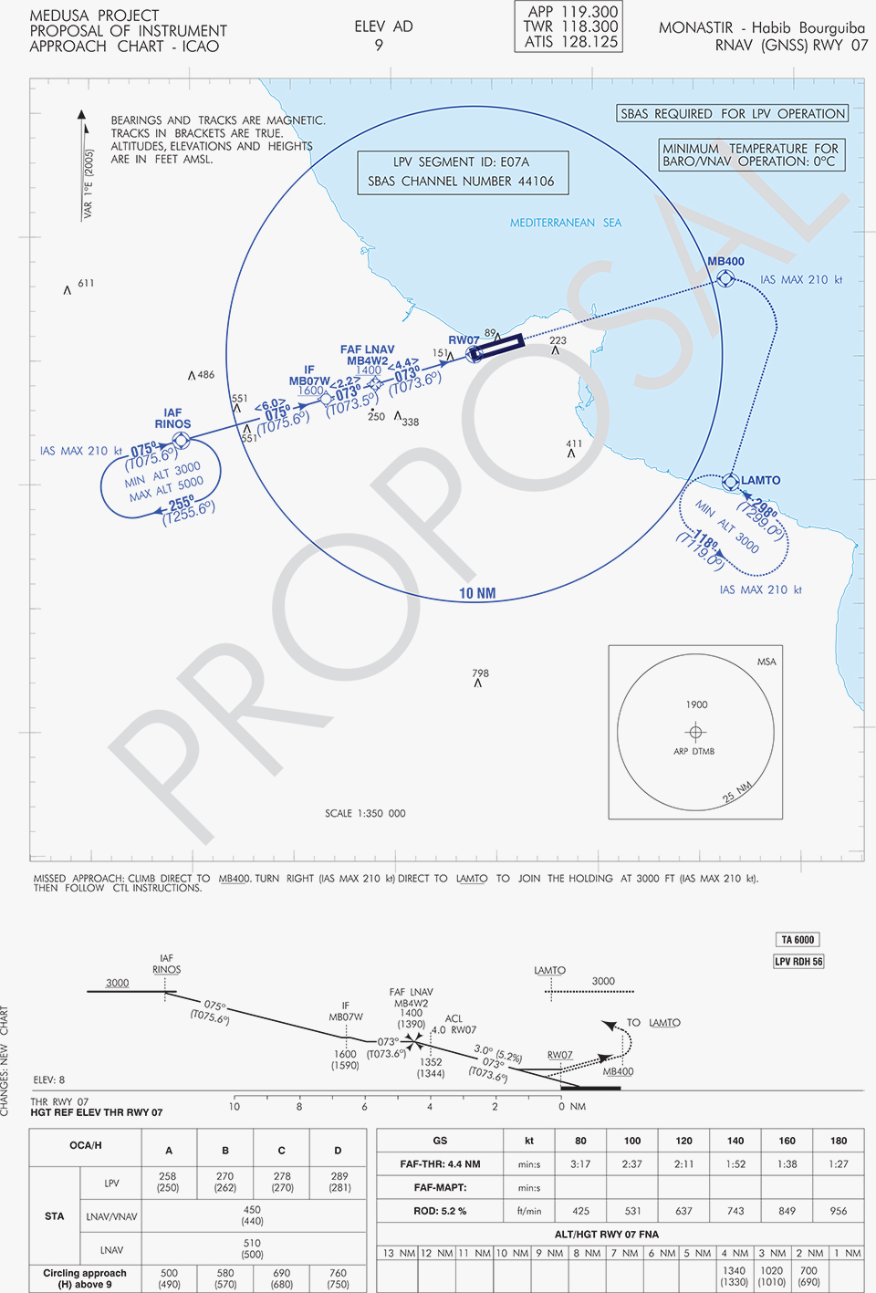
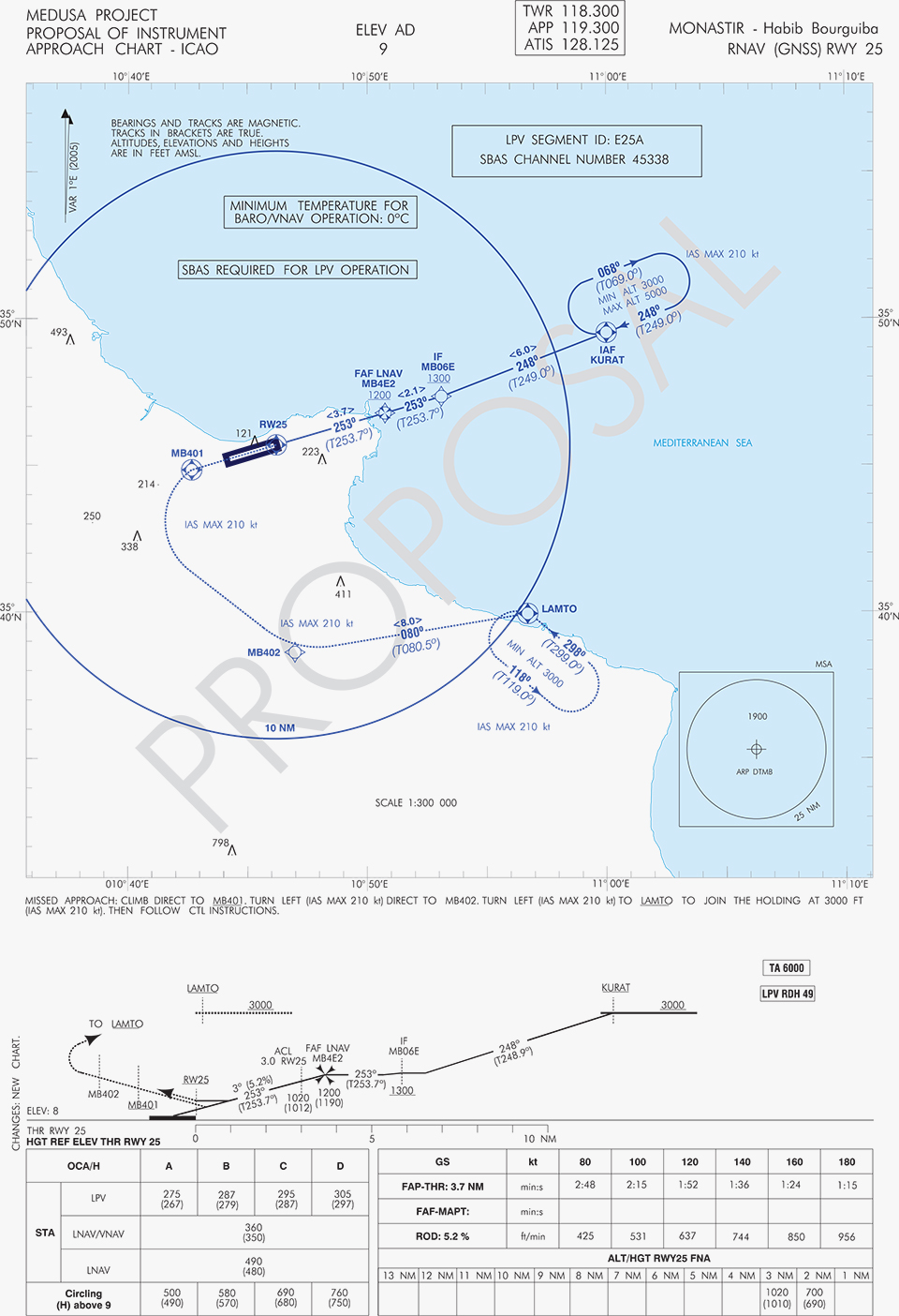
A set of three GNSS based approach procedures was produced for each RWY, following ICAO 8168 PANS OPS design principles. The next figures show the combined charts type elaborated, that include minima boxes for three RNP approaches (LNAV, LNAV/VNAV and LPV). The procedures construction preserves the current Monastir arrivals structure, following airspace management principles and facilitating the operational approval. As illustrated in the charts, in both cases for the three minima the calculated OCH (Obstacle Clearance Height) values improve with respect to the already existing conventional approaches, providing significant operational and safety benefits.
Figure 5. GNSS approaches for RWY 07.Figure 6. GNSS approaches for RWY 25.
An on-site GNSS performance monitoring campaign was performed by OACA, with the support of GEMCO’s staff, 3 months before the flight trials schedule, covering both EGNOS and GPS signal performances. Besides, an APV-I availability study for the area and specifically for Monastir airport during 1 month before the flight validation was purposely elaborated by the European EGNOS service provider (ESSP). Both analyses, confirmed suitable APV-I performance in terms of availability and continuity, making feasible the implementation of LPV approach procedures in line with ICAO prescriptions.
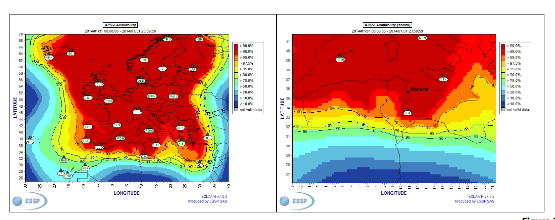
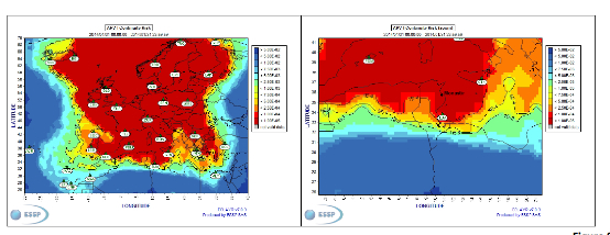
The next figures show the EGNOS APV-I availability and continuitymeasured on one day during the period of the flight validation (conducted from 30 January to 1 February 2014), in particular at Monastir airport for the considered time-lag:
APV-I availability was over 99%;
APV-I continuity presented a total value lower than 5×10⁻⁴/15s;
95th percentile of Horizontal APV-I accuracy was between 1.1 and 1.2 meters and the 95th percentile of Vertical APV-I Accuracy is around 1.4 meters, thus showing a very good accuracy level;
Horizontal and Vertical safety indexes were lower than 0.25, representing a very good integrity margin.
Additionally, the results of the on-site GNSS performance monitoring campaign showed quite stable performances with small fluctuations during the whole period of observation, and no problems or outages were observed.
(EGNOS APV-I Availability is defined as the percentage of epochs in a month in which the Protection Level are below Alert Limits for this APV-I service (HPL<40m and VPL<50m) over the total period (source: ESSP).
EGNOS APV-I Continuity Risk is defined as the result of dividing the total number of single continuity breaks using a time-sliding window of 15 seconds by the number of samples with valid and available PA navigation solution. A single continuity break occurs if the system is available at one epoch and becomes not available for the following 15 seconds (source: ESSP).)
Figure 7. APV-I availability on 31.01.2014.Figure 8. APV-I continuity on 31.01.2014.
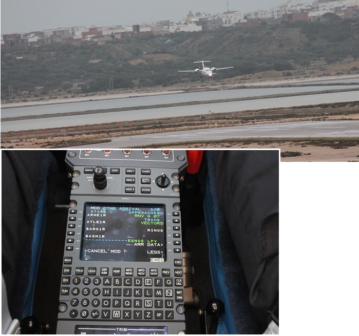
The flight validation campaign was carried out according to ICAO doc 9906 with a Piaggio P180 Avanti II (from ENAV flight inspection department) suitably equipped with UNIFIS 3000 system and a Rockwell Collins FMS 3000 with SBAS LPV approach capabilities.
Figure 9. Piaggio P180 Avanti II aircraft and the FMS messages during the flight validation.
The outcomes of this concrete experience have allowed the Tunisian authorities to identify the main elements for the publication of the validated procedures in their national AIP. They have also contributed to the analysis of the necessary process for the operational adoption of GNSS, including EGNOS, in aviation in countries beyond the EU boundaries.
The activities performed on performance assessment have been preparatory for discussions on GNSS monitoring and data recording on going at ICAO Navigation System Panel level, that would produce ICAO guidelines for States.
Therefore, this Tunisia’s “case study” represents a practical and realistic example that could be beneficial for the other non-EU countries in terms of best practice and lesson learnt. Moreover, methodology and guidelines have been derived to be possibly injected to other non-European countries interested to introduce EGNOS operations in aviation.
Lessons Learned and Outlook
Through its achievements, MEDUSA is opening the way for the introduction of EGNOS SoL service in North Africa and Middle-East region, and it is also defining a suitable path to be followed by other interested non-European countries. Overall, MEDUSA is continuing to confirm the ability to foster cooperation and involvement in EGNOS programme of the great majority of the Euromed countries. Further to Tunisia, other Euromed countries have already expressed their interest in relation to the EGNOS use in aviation, considering each country’s strategy and also in the light of a common shared regional perspective. Besides, the results obtained by MEDUSA are useful also for other regions interested to use EGNOS in aviation.
Additionally, MEDUSA is clearly showing that Euromed region, presently lacking the full support of SBAS technologies, represents an opportunity for EGNOS service extension, with many benefits for the countries of the region and for Europe.
On one hand, being SBAS an effective and efficient technology to enable the aviation community of the Euromed countries to comply with ICAO recommendations on PBN implementation by year 2016 across the region, the services coverage extension of existing SBAS systems (EGNOS in the case of the Euromed countries) can be one of the most efficient ways to move forward. In fact, the Euromed national ANSPs consider the readiness of EGNOS SoL service as one of the main drivers and factors when designing their PBN strategy. EGNOS, which is already operational since 2009 and available for use in aviation since 2011, can deliver added-value services to the Euromed region, just by leveraging the existing European infrastructure with only incremental, marginal and natural extension. The EGNOS coverage extension across the Euromed region can provide significant benefits and particularly to those Euromed countries with few ILS or reduced navaids coverage, and enhance safety and efficiency to the whole aviation community.
On the other hand, the European Union has to gain from an EGNOS-based long term links with its neighbouring regions, by increasing bilateral/multilateral cooperation and interaction (e.g. assistance, mutual cooperation) among public and semi-public bodies (e.g. ANSPs, Civil Aviation Authorities), by strengthening EGNOS SoL coverage in the southern/peripheries of EU (e.g. Malta, Cyprus, Greece, Southernest Italian islands, Canary islands), by pursuing and supporting other EU policies in several sectors (like transports, e.g. harmonizing aviation safety standards across the Mediterranean, Transport Policy of the Mediterranean Partners), and last but not least by achieving a first step towards EGNOS extension to the whole African continent which will bring in similar, additional benefits just described above.
They said it wasn’t possible — well to be frank, I said it wasn’t possible – but one of the two “misplaced” Galileo satellites, plucky Doresa, has delivered an early Christmas present to the European GNSS community by providing a first fix on Tuesday, December 9. The signal was received at the European Space Agency’s (ESA’s) technical centre in Noordwijk, the Netherlands and at the Galileo In-Orbit-Validation (IOV) test station at Redu in Belgium. Doresa teamed with the remaining three functioning Galileo IOV satellites to provide a Galileo positioning data first fix with horizontal accuracy better than two metres.
Since then fixes have also been performed using Galileo’s Public Regulated Service (PRS), the civilian encrypted highest-precision signal and one of the constellation’s unique selling points.
The satellite had transmitted its first navigation signal in space on November 29, following its attainment of a safer, more stable, and more circular orbit with the perigee some 3,500 kilometres higher than its original placement.
Doresa’s salvage has been a slow and steady journey since it was placed, with sister satellite Melina, into a fairly useless orbit in August following a launch anomaly. The original orbit, with a 26,000-kilometer apogee and a 13,800-kilometer perigee, prevented their use for navigation services because they were too low during part of their orbit to sense the horizon and correctly determine their own position. They were also getting a daily dose of radiation from the Van Allen belts.
Elevation
The elevation of the satellite started in late October and involved 11 firings of Doresa’s on-board thrusters. The craft now has only 15 kilos left from its original 65 kilo fuel payload but, given the fact that normally Galileo satellites are not required to make regular orbital manoeuvres, ESA engineers estimate this should be enough for a good 12 years of operation in the new orbit.
The next stage will be to repeat this manoeuvre with the second Full Operational Capability (FOC) satellite, Melina, according to a plan to get that into a similar orbit by the New Year. Pending tests of their positioning, navigation, and timing payloads, the two spacecraft are then likely to be able to contribute to the future Galileo navigation constellation. This was confirmed by Didier Faivre, ESA’s director for navigation, during the agency’s ministerial council meeting on December 2 in Luxembourg.
This end result is the best possible scenario given where the satellites were left after launch and is a considerable triumph for ESA’s mission control teams and flight engineers. Doresa is now able to use its Earth sensor continuously and keep its antennae orientated towards the Earth. Despite more than a month’s exposure to the Van Allen radiation, testing so far has shown no ill effects.
“The very good geometry of the satellites in the sky relative to the receivers helped us to achieve this result, plus the signal strength of the fifth satellite,” explained Gustavo Lopez Risueno, coordinating the receiver team at the Navigation Laboratory in ESA’s ESTEC technical centre.
The satellite signals should be usable immediately, in combination with additional navigation message information provided through ground networks, with mass market receivers. In fact the ESTEC Navigation Laboratory, working in conjunction with the European Commission and the European GNSS Agency (GSA), have already performed position fixes with both Galileo and GPS satellites using only navigation-assistance information.
With some adjustments to the Galileo network’s ground infrastructure, it looks like Doresa and Melina will be able to carry out most of the roles they were originally designed to do. They are the first of 22 Galileo FOC satellites to be built by OHB and launched by ESA over the next few years.
Toasted antennae
More good news. The problem with Galileo’s fourth IOV satellite, named Sif, that took it out of action at the end of May seems to have been characterised and — again — indicates that the satellite is not a complete loss to the constellation. While Sif’s E5 and E6 frequency bands are definitively blown, the satellite’s E1 Open Service band should be capable of broadcast.
The problem appears to have been a defective antennae. The four IOV satellites utilise one antennae design, while the FOC satellites have a different design. Fortunately there is no sign of a similar issue with the three other IOV craft, but they have been operating on reduced power as a precaution while the root cause of Sif’s failure is determined. ESA is currently fail-testing an example of the culprit antennae in the laboratory to see if the failure mode can be characterised.
“One of the possible root causes links the problem with the power emitted by the antenna. When we know more we’ll decide what to do with the other three. Since this event occurred in May and June, no more issues have arisen,” Faivre said.
Agreement
This is all a remarkable turnaround and good news for the wider European GNSS community and those stakeholders who have invested in the Galileo programme and its burgeoning application industry. Let’s hope the good fortune continues through 2015.
The administrative side of things is certainly moving on with the signing in October of an agreement which delegates a range of exploitation tasks for Galileo from the European Commission to the GSA, providing a framework and budget for the development of services and operations through to 2021.The signing of the agreement is an initial step towards the full Galileo Exploitation Phase. Current planning calls for this exploitation phase to be progressively rolled out from 2015, with full operability scheduled for 2020.
“With Galileo, we aim to provide a tangible service to European citizens, and this Delegation Agreement ensures we have the tools and funding necessary to achieve this,” said GSA Executive Director Carlo des Dorides. The agreement was signed by Daniel Calleja Crespo of the European Commission and des Dorides. The document specifically sets the actions to be implemented, the amount of funding provided, and the conditions for the overall management.
Innovation
In the same month, the First Satellite Masters Conference took place in Berlin on October 23 and 24. The conference encompassed the 2014 edition of the European Satellite Navigation Competition (ESNC). The event was a great showcase for the innovation, skill, and passion of the entrepreneurs, usually young, who are building the satellite application market in Europe.
For example, the winner of the GSA special prize at ESNC 2014 is developing Galileo modules for the Google Ara modular smartphone concept, a potential game-changer for positioning in the mobile-phone market. Ara uses interchangeable modules to deliver a smartphone that can be whatever a user wants it to be, complete with first- and third-party components including sensors, cameras, radio antennas, and more. Consumers will be able to order them as of January 2015.
Google developers believe an Ara smartphone will last multiple years, much longer than current hardware, since it won’t be obsolete nearly as quickly. Further, Ara could open the smartphone market to billions of new users across the globe.
I spoke with Giovanni Vecchione of Deimos Space, who received the € 40 000 GSA/ESNC prize during the awards ceremony at Deutsche Telekom’s magnificent headquarters in the German capital.
“With a traditional chip structure, all of a smartphone’s functions are currently combined into a single component, which makes it difficult to add or change a function,” explained Giovanni. “With a modular structure, you have the option to simply switch out a component, meaning a smartphone’s capabilities can be easily enhanced.”
Vecchione’s innovation is to use another of Galileo’s unique selling points: the E5 broadband signal. While mass market smartphones will use the E1 signal, the availability of high-end phones offering enhanced accuracy through the use of the E5 signal will appeal to many users. A second module will implement an external antenna interface. Together these developments could deliver an ARA phone offering high precision (centimetre-level accuracy) positioning and multipath-resistant solutions.
Wishing you all a very peaceful and prosperous New Year and hoping Santa has your coordinates accurately entered in his sleigh satnav!
Will Be Employable for Surveying, Precise Positioning, and Geodesy
By Peter Steigenberger and André Hauschild, German Aerospace Center (DLR) / German Space Operations Center
The first Full Operational Capability (FOC) Galileo satellite started transmitting L-band navigation signals on November 29, 2014. Based on data collected by a global network of GNSS tracking stations of the Cooperative Network for GNSS Observation (CONGO) and the Multi-GNSS Experiment (MGEX) of the International GNSS Service (IGS), we determined that an E1 signal with pseudorandom noise code (PRN) E18 was first tracked at the station LLAG (La Laguna, Tenerife, Canary Islands) at 06:08 UTC. A few moments later, the satellite’s transmissions were also tracked at other MGEX stations including the E5a, E5b, and E5 AltBOC signals. Based on the computed satellite visibility at various tracking stations, the satellite could be positively identified as GSAT0201, also known as Galileo FOC-FM1 or Galileo 5 with COSPAR ID 2014-050A and NORAD ID 40128.
FIGURE 1 shows the carrier-to-noise-density ratio (C/N0) of the E18 signals tracked at the CONGO/MGEX station SIN1 (Singapore, using a Trimble NetR9 receiver with a Leica AR25.3 antenna). We selected the signals from this station for analysis due to an E18 pass occurring close to the zenith and covering almost the full range of elevation angles. The E5a and E5b signals (S5X and S7X RINEX identifiers) show very similar performance, whereas the C/N0 values of the E1 signal are 1–2 dB-Hz higher. The C/N0 values of the E5 AltBOC signal (S8X) reach 60 dB-Hz at high elevation angles, which is about 6 dB-Hz higher than the other signals.
Figure 1. Galileo E18 carrier-to-noise-density ratio for the CONGO/MGEX station SIN1 (Singapore).
The first pair of Galileo FOC spacecraft was launched on August 22 with a Soyuz launcher from the Guiana Space Centre, Kourou, French Guyana. Due to a malfunction of the Fregat upper stage, the satellites were injected into elliptical orbits with an inclination of about 49° instead of near circular orbits with 55° inclination. In November, the perigee of the first FOC satellite was raised by about 3,500 kilometers by a series of 11 maneuvers with a corresponding reduction in orbit eccentricity from 0.23 to 0.16.
E18 has been included in the precise orbit and clock solutions of the MGEX analysis center at Technische Universität München (TUM) in Munich, Germany, since December 5. FIGURE 2 shows the detrended estimates of the active Galileo E18 clock for December 7. The presence of a pronounced quadratic term as well the large drift of 33.9 microseconds per day indicate that the active clock is a rubidium atomic frequency standard rather than a more precise passive hydrogen maser. The FOC satellites carry two of each kind of clock.
Figure 2. Galileo E18 clock estimates for December 7, 2014, with respect to the hydrogen maser at the Ottawa IGS station (NRC1) after removing an offset and drift (blue) or a second order polynomial (red).
The TUM orbit and clock product allows researchers to again compute dual-frequency positioning solutions using only Galileo observations, as the In-Orbit Validation satellite E20 has not transmitted an E5 signal since May, when a power anomaly left the satellite with the capability to only transmit an E1 signal. Furthermore, E20 currently does not transmit a navigation message.
TABLE 1 shows the scatter of single-point positioning using pseudorange (code) observations from the MGEX station MAS1 (Maspalomas, Gran Canaria, Canary Islands) for a Galileo-only, a GPS-only, and a combined Galileo+GPS solution for December 6. At an elevation cut-off angle of 10°, four Galileo satellites were visible from 10:15 until 12:25 UTC (see FIGURE 3). The GPS-only solution covers the same time interval. The start time is not limited by the cut-off angle but an E18 transmission outage from 3:45–10:15 UTC.
TABLE 1. Single point positioning results for the MGEX station MAS1 (Maspalomas) for December 6, 2014.Figure 3. Galileo visibility at the MGEX station MAS1 (Maspalomas) on December 6, 2014. The time period considered in the single-point positioning is indicated by vertical lines.
We used an ionosphere-free linear combination of Galileo E1 and E5 AltBOC code observations and GPS L1 and L2 code observations with a 30-second sampling interval. As the Galileo-only solution suffered from position dilution of precision (PDOP) values of up to 830, a total of 32 epochs with PDOP values greater than 25 were excluded. The geometry of the remaining epochs is still pretty unfavorable. At a mean PDOP value of 7.4, the standalone position solution exhibits a 3D standard deviation (STD) error of 3.4 meters. Use of the Galileo satellites in a combined GPS+ Galileo solution improves the positioning performance. In particular, the height component benefits from the inclusion of the four Galileo satellites with a standard deviation improvement of 25 percent.
Despite the orbit injection error, the new Galileo FOC satellite has now been successfully activated and added to the Galileo constellation. Unfortunately, the current orbit is incompatible with the standard Galileo almanac format, which may cause restrictions for some commercial receiver types.
Nevertheless, the satellite can already be tracked by a wide range of geodetic receivers with existing firmware versions and it will, in fact, be possible to use the new satellite for diverse applications in surveying, precise positioning, and geodesy, as well as in general multi-GNSS studies. We now look forward to the activation of the second FOC satellite, which can be expected in early 2015 and will, for the first time, offer multi-frequency signals from a total of five Galileo satellites.
BeiDou Signals, Future Receiver Design Highlighted at Stanford PNT Symposium
By James D. Litton and Tom Langenstein
James L. Litton
The Stanford Center for Position, Navigation and Time conducted its eighth symposium on PNT in October 2014. These symposia have always been a superb two (this year three) days of excellent presentations, ranging over the entire domain of PNT, including policy factors as well as technical ones.
This year the first day featured student speakers, either from Stanford or the students of former Stanford students who are now faculty at other universities. The conference is by invitation only; sponsors include Lockheed Martin, Boeing, and other companies involved with GNSS. This essay highlights two presentations that struck us as harbingers of change in the industry: Greg Turetzky’s paper on ubiquitous location, and Minquan Lu’s and Zheng Yao’s paper on new signal structures for BeiDou.
Brad Parkinson gave a keynote address mixing challenges and opportunities from the frontiers of policy formation. David Last did not fail to amuse with his lighthearted and satirical commentary on navigation and society at dinner. Many others gave noteworthy presentations, and all of the presentation slides can be found online.
Tom Langenstein
Both papers that we selected for this article have very broad scope with considerable strategic significance in GNSS design and applications. It seems a little impertinent, as well as superficial, to try to convey their essence in fewer than 2,000 words, but the material presented is available elsewhere, too.
New Signal Structures for BeiDou
Professors Mingquan Lu and Zheng Yao of Tsinghua University laid out in clear and detailed fashion the motivations for BeiDou’s choosing to introduce new signals for the Phase III global system, analyses of alternative modulations, and the results of bench testing in service to the desired properties (interoperability, acquisition and tracking thresholds, receiver complexity, in-band interference, and so on).
They emphasized one non-technical or operational motivation: independent proprietary designs for patent protection. No declaration of policy intention was made; however, the direction was clear, even though the authors are university professors and not government officials.
Some of this work has been published elsewhere in IEEETransactions by the same authors and has a substantial history, reflecting the lessons learned from the predecessor system designs and very thorough analysis, simulation and bench testing. Space does not allow extensive citation, but the key drivers for the designs and the results are summarized below. The preferred modulations chosen or synthesized are quadrature multiplexed binary offset carrier (QMBOC) for B1C and asymmetric constant envelope-binary offset carrier (ACE-BOC).
The principal deficiencies cited of the earlier-proposed BeiDou Phase III signals (circa 2010-ICG) were given as:
no independent intellectual property rights; thus, a big patent risk
signal performance needs to be improved
more flexible receiving modes and more varied application scenarios should be considered.
The principal requirements for BeiDou Open Service signals were cited as:
independent intellectual property rights
better compatibility and interoperability with GPS and Galileo
smooth transition from Phase II to Phase III
improved performance
Separate requirements were stated for the B1C and B2 signals, as follows:
B1C: (QMBOC)
compatibility with other signals of the same carrier frequency
better interoperability with GPS L1 and Galileo E1 signals
better ranging accuracy (than GPS C/A and BeiDou Phase II B1(I))
receiving mode diversity for different receivers (low-end and high-end)
independent Intellectual property rights
B2C: (ACE-BOC)
multiplexed B2a and B2b into a constant envelope signal
better interoperability with the GPS L5 and GALILEO E5 signals
In the quoted case study tests, simulated ACE-BOC and AltBOC signals were generated at several fixed transmitting power levels and processed using software receivers. For each given transmit power level, the ACE-BOC was allotted three times power for the pilot channel over that of the data channel while the AltBOC allocated equal amount of power for both the pilot and the data channel, that is, 3:1 for ACE-BOC and 1:1 for AltBOC.
The resulting tracking performance of the ACE-BOC is more robust than that of the AltBOC.
Table 1, taken from the presentation, provides an overview of the signals.
Table 1. New signal structures proposed for BeiDou.
The compatibility properties of the new signals, if adopted, which seems quite likely, are desirable. The implicit intellectual property aspects of the development, both in motivation and in differential design of a signal structure which seems to be claimed as novel have a defensive basis, apparently, in earlier assertions of proprietary designs. It will be interesting to see whether similar international negotiations follow, or perhaps already have. The paper was well received and stimulated considerable hallway comment.
Ubiquitous Location
Turetzky’s paper laid out the phenomenal growth of location-based services and the implications of such growth for design requirements in GNSS-wireless at the user device level and at the silicon level. On growth (from various quoted sources):
The compound annual growth rate of GNSS devices will continue, from its current 22 percent level to a robust 9 percent for the years 2016-2022; heading for seven billion installed units by 2022.
The cumulative core revenue in the decade 2012-2022 will be 46 percent in LBS portable and wearable devices and 47+ percent in vehicles.
There will be many billions of installations of indoor location technologies by 2018, in virtually every venue imaginable.
Some of the design implications of the requirements driving the growth in indoor location are:
Always Located, or continuous location. For this case, the energy dissipated per day (16 hours) and signal availability (100 percent) are the featured specification and the secondary specification, respectively. These specifications, in turn, require hybrid constellations and minimal standby power consumption.
The scaling down to very small (14 nanometer) dimensions enables much faster switching speeds, search rates and lower power dissipation in active modes and more complex algorithms, but at the expense of leakage current, which adversely affects standby power, an increasingly important factor.
Thus, for GNSS design, the challenges are to:
Take advantage of benefits of smaller geometries to achieve higher clock speeds, more memory, lower active power and smaller size, while greatly reducing standby power from leakage;
Incorporate new methodologies at chip and system design level; Integrate multiple radios on a single die to reduce cost and size without creating interference to a very sensitive GNSS radio;
Integrate multiple radio sources into a single location solution;
Bring together a disparate value chain;
Turetzky outlined a vision for his employer, Intel, to be a leader in all aspects of these revolutionary developments. The technology roadmaps embrace most modalities of positioning: GNSS, Bluetooth, WI-Fi, cellular, and SBAS, and cross most platforms, including wearables. We think that another, unemphasized challenge is in the increasing density of these units with the current specifications on out-of-band-emissions and the spectrum sharing and spectrum management factors in the ubiquity of the devices.
From Greg Turetzky’s Ubiquitous Location paper, presented at Stanford PNT Symposium.
Tune in to our free webinar Receiver Design for the Future,with Greg Turetzky of Stanford speaking on Ubiquitous Location, scheduled for Jan. 15 (1 p.m. EST/ 10 a.m. PST/ 6 p.m. GMT). Register today!
Both papers represented the dynamism of our industry and its diversity of technologies and practitioners and the service to that industry provided by the remarkably consistent excellence of this symposium.
James D. Litton heads the Litton Consulting Group and previously played key executive roles at NavCom Technology and Magnavox.
Tom Langenstein is executive director of the Stanford Center for Position, Navigation, and Time, and deputy program manager of the Gravity Probe-B project.