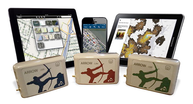
Eos Positioning Systems has introduced a new line of high-accuracy GNSS receivers for smartphones and tablet computers, including both sub-meter and RTK performance for all mobile platforms: iOS, Android, and Windows.
Eos’s entry-level product, the Arrow Lite, is Bluetooth compatible with all mobile devices.
The Arrow 100 is Eos’s advanced real-time, sub-meter GNSS receiver that utilizes both GPS and GLONASS, and is expandable to Galileo, Beidou and QZSS. It offers superior tracking under tree canopy, around buildings and in rugged terrain, the company said. In addition to supporting SBAS in North/Central America, Europe, Northern Africa, Japan, India and Russia, the Arrow 100 also supports OmniSTAR’s worldwide, real-time sub-meter service.
The most advanced Arrow receiver is the Arrow 200, a dual-frequency, multi-constellation RTK GNSS receiver capable of 1-cm accuracy in real time. The Arrow 200 is an iOS-compatible RTK and OmniSTAR receiver that works with all models of iPads and iPhones via wireless Bluetooth connection. An iOS NTRIP app that allows the user to log into any available RTK network. The Arrow 200 will provide quality RTK performance for years to come because it supports current and future satellite constellations: GPS, GLONASS, Galileo, BeiDou and QZSS, the company said. It also supports OmniSTAR’s G2, XP and HP real-time worldwide decimeter services.
“After spending more than 12 years designing high-accuracy Bluetooth GNSS receivers, I believe Eos has set the new standard for high- accuracy GNSS receivers that work across all mobile platforms, no matter if it’s iOS, Android or Windows,” said Chief Technology Officer Jean-Yves Lauture.
All Arrow receivers employ long-range (1-km) universal Bluetooth connectivity so the user can interface to any brand of smartphone or tablet, whether it’s iOS, Android, or Windows-based. A variable-power Bluetooth implementation allows the Arrow receivers to communicate up to one kilometer from the mobile device.
Arrow receivers have been optimized to run all day on battery power. The battery pack is field-replaceable and rechargeable separately. It contains smart charging logic so expensive battery chargers are not needed.
All Arrow receivers have been designed to meet IP-67 specifications for immersion in water and are completely dust-proof so they will survive in the harshest environments.
The Arrow receiver product line is targeted at high-accuracy applications like GIS, environmental, agriculture, electric/gas/water utilities, surveying, machine control, and federal/state/local government.
Macy’s added Shopkick indoor location beacons in preparation for holiday shopping. (Photo by Nicholas Eckhart is licensed under CC BY 2.0.)
This year was filled with hope and some success for the location industry. In what was probably the biggest deal, Qualcomm bought United Kingdom-based CSR for $2.5 billion — at the same time, spinning off its own location beacon company, Gimbal. While the connected car continued to get a lot of press at the biggest trade shows, indoor location technology matured to a point that many retailers are believing it’s a way to get consumers back into the stores — and away from their computers.
As we come to the end of 2014, many industry observers view indoor technology and markets to be like where outdoor location was in the early 1990s: many technologies and providers all pushing different solutions. However, the gap between the beneficiaries of the market, the retailers and brands, and the indoor location technology providers is narrowing as tests become more prevalent.
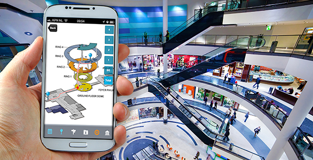
Such retailers as Walgreens, Home Depot, Lowe’s, Macy’s and CVS have rolled out, or planning to launch, tests that include indoor mapping and a product locator.
“iBeacons and other beacons proved to be the fastest location-proximity technologies that are being deployed full scale by Macy’s, CVS and other retailers for a first quarter 2015 rollout,” said Kris Kolodziej, an indoor location-based services advisor. “I see more acquisitions like the one of Groupon acquiring Swarm Mobile, a beacon platform for smaller tier-two retailers and businesses. In addition, we will see more partnerships like the one between Gimbal and Urban Airship to provide a holistic outdoor-indoor solution for geofencing and engagement platforms.”
Location companies paid attention to mobile carriers’ focus on launching and advancing their LTE services in 2014, said Keith Bhatia, TeleCommunication Systems vice president, business development.
“2014 has been the year of transitioning location-based services from 2G to 3G to complete 2G-3G-4G platforms,” he said. “The other significant location market event for TCS during 2014 has been growth of user plane services by (over-the-top) apps. The operators who have chosen to compete with OTT players have seen location requests exponentially expand.”
TCS believes that the location market, in the next five years, will evolve to a machine-to-machine and Internet of Things (IoT) concepts that will expand into consumers’ everyday lives, Bhatia said. “From the connected car to telemedicine, health devices, connected home and smart cities, all mobile connected devices will benefit from location-based services,” he said. “We believe that location services will continue its rapid growth for years to come.”
Selling retails on the promise of indoor positioning and proximity marketing has been tough in the past few years — and some providers have focused on the wrong message, Bhatia said. “As mobile device adoption continues to surge, indoor positioning and proximity marketing will become an important tool for many retailers. A significant barrier so far has been too much focus on coupon delivery,” he said. “We believe the retailers will find real benefits in terms of understanding layout, traffic and congregation of users. Combining this location information with their retail data will provide early insights into trends and early indications of potential challenges.”
Dave Hutingford, CSR director of product line for location, believes the big selling point for retailers is striking the balance between what benefits they obtain from the app versus what benefits the consumer gets — what he calls the equity balance.
“Too many irrelevant notifications while walking around the shop will result in people not wanting to run the app, and can potentially harm consumer acceptance of retail applications. The interest is already there from the retailers’ side as the benefits are somewhat obvious, but the question is what do you give back to an increasingly technology-smart consumer?” he said.
Overall, the indoor location market is attracting major interest from retailers — which is refreshing to many industry observers after seeing online sales cut into brick-and-mortar stores’ profits.
“Removing the need for dedicated infrastructure to run indoor location was a big hurdle removed from the ecosystem. Certainly we expect to see good pick-up of the solution over the next few months for a wide variety of location services, and being handset-agnostic is a big benefit for any developer,” Hutingford said. “However, if you are looking for accuracy down in the meter range, you will need to add infrastructure to supplement the location calculation, which can come in many forms.”
Connected-Car Market Made Headlines in 2014
If an industry executive attended any of the bigger trade shows this year — CES, CTIA in Las Vegas, or the Mobile World Congress in Spain, it was the same thing — connected vehicles are the big story. Adoption by automotive manufacturers, as a number of analysts have pointed out this year, was the most important news story for the connected-car industry in 2014, said John Horn, Kore Telematics executive vice president and chief strategy officer.
“Essentially every vehicle that rolls off the assembly line in 2015 will have an element of connectivity built into it. To keep up with the level of demand, we are starting to see scale and scope really start to matter to the companies that power this type of connectivity,” he said. “2015 will prove to be another huge year for industry consolidation, which will be necessary to keep up with the global demand for connected-car technologies.”
The biggest trend in 2014 connected-car technology was the emergence of infotainment content for connected cars, said Scott Frank, Airbiquity vice president, marketing. “Before 2014, the most an average consumer would expect out of a high-end vehicle head unit were features like navigation, basic cell-phone connectivity, and hands-free calling,” he said. “Today, drivers are able to get a wide-variety of apps in their vehicles to do things like stream music and keep up with their social media channels. User experience advancements were also made to provide a seamless transition for digitally oriented drivers as they moved from office, to car, to home, and back again. For example, with the NissanConnect Mobile Apps system, someone listening to a streaming music app like Pandora on their PC in the office can put it on hold, get into their car for the drive home, and pick up the song right where they left off — as well as see their favorite playlists, album selections, and cover art.”
However, as with any industry that experiences quick growth, there will be growing pains, Horn said. “The automotive world has already started to experience some of those pains as connected technologies continue to advance at a rapid pace. We saw how the analog shutdown left many OnStar customers stranded with obsolete hardware,” he said. “We’ll likely see similarities as 2G, 3G, and 4G networks are eventually turned down in favor of more advanced technologies. I’ve been saying this for years, but now is really the time for the removable module. Connected technologies will turn over much faster than cars, and the only way I can see to future-proof against this is through the removable module.”
Airbiquity’s Frank said that there are definitely consumer acceptance and technology barriers for the automotive industry going forward related to connected car as we know it today and autonomous car as its being forecast going forward.
Like waves of technology that have come before, functional consumer awareness and adoption will follow the technology adoption curve, Frank said. “Certain generations and user types will be early adopters and more likely to accept new and evolving connected-car technology and features — and the user experiences and value that come with it — the minute it’s made available,” he said. “While others will be either blissfully unaware of the technology built into their car — and the value it could bring them — or are simply satisfied with traditional technology like basic AM-FM and satellite radio. One thing for sure is there’s a correlation between early adopters of technology like smartphones and early adopters of connected-car technology and related features.”
Frank quoted a recent Parks Associates study that found 48 percent of vehicle owners that own smartphones are very interested in the ability to view maps — or receive directions in their cars. This compares to 37 percent of vehicle owners that own/don’t own smartphones. “Like flip-phone users that transitioned to smartphones after understanding the end benefits, consumers will increasingly become aware of and use their connected-car systems,” he said. “We’re seeing evidence of the connected-car adoption curve in the increasing activation rates and time of usage for our customer’s connected-car programs.”
Horn, who headed RacoWireless, which was acquired by Kore for an undisclosed amount this year, said in 2015 industry will start to see the connected car become much more easily monetized. “We’ve seen this first hand, as we have just rolled out some new features with AT&T and Audi. Now, your Audi Connect subscription can be part of your AT&T Mobile Share plan and treated just like another line,” he said. “It is going to be easier than ever to consume in-vehicle connectivity and the business model will advance to the point that makes it appealing for both the consumer and the solution provider.”
In 2015, driving-centric apps and services will begin to appear and eventually become as important as infotainment content in the consumer purchasing process, Frank said. “The current automotive manufacturers’ focus on providing infotainment delivery reflects their desire to meet the expectations of digital lifestyle consumers who are heavy users of smartphones and want to use their favorite apps and services inside their cars,” he said. “This is a logical first step, but these savvy consumers will increasingly value apps that are truly useful and relative to the driving experience. An example is an app that proactively and dynamically recommends modifications to a driver’s high-frequency routes to help them optimize fuel consumption, lower CO2 emissions, minimize engine wear, and avoid road hazards. As a result, apps that don’t add to the consumer experience relative to driving will eventually die off from lack of use, and automotive manufacturers will replace them with more and more driving-centric apps to satisfy their customers and differentiate themselves from competitors.”
The rise of autonomous vehicles, a derivative from connected-car technology, will keep automakers, carriers, suppliers and government agencies busy for decades.
“When it comes to autonomous vehicles, we expect the adoption curve to be more extended than what we’ll see for the connected car, given the increased consumer concerns about safety and adapting to the new fangled idea of riding in a car without a human driver,” Frank said. “Consumers will not only want to know what this fancy new technology is and how it works, they will also need to feel confident that it will run perfectly and not put themselves, their passengers, or other people and property in harm’s way. Consumers will also have concerns about who will be legally and financially liable if an accident occurs.”
In other location news:
Two Trimble companies, PeopleNet and ALK, recently provided real-time tracking of the 2014 Capitol Christmas Tree’s cross-country journey from the Chippewa National Forest in Minnesota to the front lawn of the U.S. Capitol Building in Washington. The companies used enterprise products for routing, mileage, mapping and visualization to track the tree.
LBS Insider’s Kevin Dennehy will be attending the 2015 Consumer Electronics Show in Las Vegas next month. Please contact him at [email protected] with your story ideas.
The FCC will soon make a ruling on indoor location rules for 911 calls. If you worked in the location industry in the late 1990s, you may remember when the FCC ruled that wireless carriers would have to automatically locate a mobile phone that dialed 911 from the outdoors. From a seat on the E9-1-1 Institute’s board, a non-profit organization that supported Congress on 911 public safety issues, I watched the wireless carriers fight meaningful 911 location accuracy standards and monitoring.
With the large number of calls to 911 from the indoors today, the FCC is about to require carriers to automatically provide emergency dispatchers with indoor location information on calls. In the short term, the FCC is proposing indoor location that would provide sufficient information to identify a building, with more granular accuracy in the long term at the room or office suite level. In addition to horizontal locations, the FCC proposes adding vertical location, a critical metric for multi-storied buildings.
The comment period for the FCC’s proposal just ended and it is now up to the agency to act. During the comment period, carriers, public safety entities and vendors fought over accuracy rules and monitoring. NENA and APCO, leading public safety organizations, negotiated a consensus agreement on indoor location rules that many other prominent public safety agencies have decried as objectionable. It is surprising that NENA and APCO would sign on to such a watered-down version of the FCC proposal.
On a better note, indoor location for commercial applications is an industry bright spot. Hyper-location is king and is moving beyond retail to enterprise, personal asset tracking (please find my keys) and the connected home. “Over the past 12 months there has been a considerable change in deployments as companies have moved from a handful of deployments to getting into the hundreds and thousands of stores,” said Patrick Connolly of ABI Research.
In 2015, Connolly also expects to see camera analytics companies like Shoppertrak, Irisys and Brickstream have an increasing presence as they expand their offerings into BLE, Wi-Fi and in-store analytics. LED lights for location positioning within retail outlets and large public venues are on Connolly’s list for market growth in the coming year. The lights enable communication with the cameras on customers’ smartphones to determine their locations. Retailers can send information, redemptions, maps and services to customers via their mobile device at precise locations within the store.
I’d like to close the year with a “departure.” In Los Angeles, a proposed cemetery on the tony bluffs of Malibu would forego headstones, raised or flat, and depend on the grieved using GPS to find the burial spots of loved ones. A small disc on the plot would verify the coordinates. GPS as we didn’t imagine it.
SiRFusion SDK brings plug-and-play simplicity to Android app developers.
With location industry consolidation, several companies are looking at established players to grow niche markets. United Kingdom-based CSR is leveraging several technologies to grow the nascent indoor location market into a powerhouse.
As GPS World recently reported, Qualcomm agreed to buy CSR, based in the United Kingdom, for $2.5 billion to boost its automotive infotainment and Internet of Things (IoT) offerings.The deal makes Qualcomm, which spun off its Gimbal location beacon technology into an independent company, a major competitor to chipmaker Broadcom.
Long term, CSR believes that multiple technologies, ranging from satellite- and cellular-based to local beaconing, will allow consumers to expect higher quality location services, said Dave Huntingford, CSR’s director of the location product line. “As part of improving accuracy, we also expect to see the emergence of dual-frequency operation of GNSS in consumer automotive — and, as part of improving security, better spoofing protection,” he said.
CSR recently launched its SiRFusion software development kit, SDK, for Android app developers. The company says the software will enable indoor positioning for developers who want to add such new capabilities as indoor location tagging and analytics for social networking.
“We expect to see good pick-up of the solution over the next few months for a wide variety of location services, and being handset-agnostic is a big benefit for any developer. However, if you are looking for accuracy down in the meter range, you will need to add infrastructure to supplement the location calculation, which can come in many forms,” Huntingford said.
Hutingford believes the big selling point for retailers is striking the balance between benefits they obtain from the app vs. benefits the consumer gets — what he calls the equity balance.
“Too many irrelevant notifications while walking around the shop will result in people not wanting to run the app, and can potentially harm consumer acceptance of retail applications. The interest is already there from the retailer side as the benefits are somewhat obvious, but the question is, what do you give back to an increasingly technology-smart consumer?” he said.
Overall, the indoor location market is attracting major interest in retailers — which is refreshing to many industry observers after seeing online sales cut into brick-and-mortar stores’ profits.
“iBeacons and other beacons proved to be the fastest location-proximity technologies that are being deployed full scale by Macy’s, CVS, and other retailers for a first quarter 2015 rollout,” said Kris Kolodziej, an indoor location-based services advisor.“I see more acquisitions like the one of Groupon acquiring Swarm Mobile, a beacon platform for smaller tier-two retailers and businesses. In addition, we will see more partnerships like the one between Gimbal and Urban Airship to provide a holistic outdoor-indoor solution for geofencing and engagement platforms.”
According to the GLONASS satellite manufacturer, the company will now produce nine GLONASS-K1 satellites rather than move to GLONASS-K2, because of the sanctions restricting the delivery of radiation-resistant electronic components from the West.
Nikolai Testoyedov, CEO of Information Satellite Systems Reshetnev, told the Russian magazine Vestnik GLONASS, “For a smooth transition to a multi-functional group and due to issues with the very complex GLONASS-K2 satellites, we decided to continue with the GLONASS-K1 intermediate range of satellites, and we are preparing for the launch of nine units of this series.”
He said the original plan was to launch two K1 satellites and then move to GLONASS-K2 satellites.
“In the beginning, really, we wanted after the two GLONASS-K1 satellites No. 11 and 12, to go for the launch of more advanced GLONASS-K2 devices. But, unfortunately, the plans had to be adjusted somewhat because of the sanctions restricting the delivery of radiation-resistant electronic components from the West. We have to put a hold on the in-depth development of technical and technological documentation and that delays us in terms of moving ahead by at least a year or two,”he said.
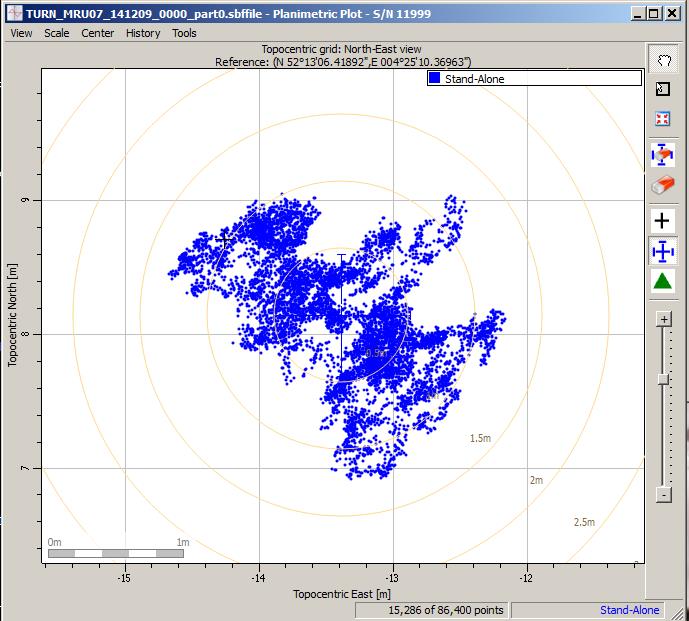
Scatter plot of the Galileo fix performed in ESA’s Navigation Laboratory at its ESTEC technical centre on 9 December 2014. The plot was calculated by the Lab’s Septentrio Test User Receiver, with dispersion of less than 2 m.
News from the European Space Agency
Galileo’s fifth satellite — recently salvaged from the wrong orbit to begin navigation testing — has been combined with three predecessors to provide its first position fix.
Test receivers at ESA’s technical centre in Noordwijk, the Netherlands, and at the Galileo In-Orbit Test station at Redu in Belgium received the signals at 12:48 GMT on December 9 from the quartet of satellites and fixed their horizontal positions to better than 2 meters.
This achievement is particularly significant because the fifth satellite is the first of a new design of 22 Galileo satellites set to be launched over the next few years.
Further position fixes were then made by France’s CNES space agency in Toulouse, France, as noted by Bernard Bonhoure: “The results are as good as those for the first Galileo fixes in 2013 with the initial four satellites.”
The following day, fixes were performed using Galileo’s Public Regulated Service, the encrypted highest-precision class of signal.
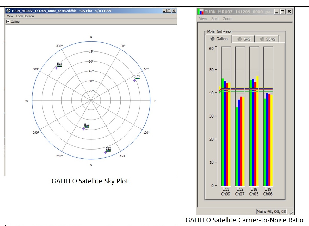
“The very good geometry of the satellites in the sky relative to the receivers helped us to achieve this result, plus the signal strength of the fifth satellite,” explained Gustavo Lopez Risueno, coordinating the receiver team at the Navigation Laboratory in ESA’s ESTEC technical centre.
“This is a significant milestone for the Galileo program because it marks the very first time that a Full Operational Capability satellite has performed a fix together with its In-Orbit Validation predecessors — which were the first four satellites launched into orbit, in 2011 and 2012. This establishes they work together well.
“While it is not yet possible to make routine use of the fifth Galileo, this shows such an outcome is within our reach.
Galileo satellite geometry and received signal strength for the December 9 fix using the first Galileo FOC satellite. The first Galileo FOC satellite corresponds to E19 on the left display; IOV PFM to E11, FM2 to E12 and FM3 to E19.
“In particular, it opens the door to its immediate use in combination with additional navigation message information provided through ground networks, which is a standard mode of operation for mass market receivers, such as those found in our smartphones.”
The fifth and sixth satellites were delivered into the wrong orbit by their Soyuz–Fregat rocket in August. Their elongated orbit took them out to 25,900 km above Earth and back down to 13,713 km, rather than the planned circular path at 23,222 km. The angle of the orbit to the equator was also wrong.
The satellites’ shifting altitude left them unable to lock onto Earth for part of each orbit, preventing them from being used for navigation purposes.
But, last month, a series of 11 maneuvers took the fifth satellite into a more circular orbit, some 3500 km higher, allowing its navigation payload to be switched on for testing. A similar salvage operation is planned soon for its companion.
The main hurdle in using the fifth (and subsequently sixth) satellite operationally is that mass market receivers in particular might take longer to find it. Their orbits fall outside the almanacs satellite-locating standard broadcast within navigation messages.
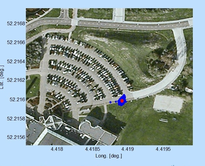
Utilizing navigation-assistance information would be a way of shortening acquisition times — and ESTEC’s Navigation Laboratory has already demonstrated it with mass market receivers.
Working in conjunction with the European Commission and Europe’s Global Navigation Satellite Systems Agency, the Lab performed position fixes with both Galileo and GPS satellites using only navigation-assistance information.
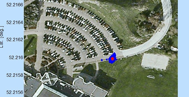
Test position fix in the grounds of ESTEC, performed with a mass-market receiver using navigation-assistance information, based on signals from the fifth Galileo satellite plus GPS satellites. This satellite’s elliptical orbit means extra data are needed to speedily utilize its signals, which could be provided through ground networks. Navigation-assistance information is already employed by the mass market receivers found within smartphones. Source: European Space Agency
EDITOR’S NOTE: Researchers at the German Aerospace Center (DLR) report on their success in producing a pseudorange-based all-Galileo position fix using precisely determined satellite orbits and clocks from Technische Universität München (TUM) in the January issue of GPS World. Richard Langley reports that his team at the University of New Brunswick has managed to produce a Galileo-only carrier-phase-based precise-point-positioning solution with better than decimeter accuracy using TUM’s orbits and clocks.
Also, GMV performed a first Galileo-only PPP with IOV + FOC-1 satellite with data from December 6, obtaining centimetric accuracy. Read about their results on their blog.
NavCom’s StarFire RTK receivers enable fast and precise GPS/GNSS data collection, according to the company. Its suite of RTK tools — Ultra RTK and RTK Extend — allow users to achieve RTK accuracy from 40 kilometers away while coasting through radio communication outages. The StarFire Network provides global 5-centemeter-level, real-time accuracy without the need for local ground base stations, NavCom says.
Who is MicroPilot? For almost anyone in unmanned aerial vehicle (UAV) electronics — or, rather, avionics — MicroPilot is probably a familiar name. The company makes the autopilots that basically fly the vehicle. An autopilot is the business-end of the navigation guidance system on a UAV. It takes input from sensors — typically GPS, air data, and inertial/gyro, which can be internal or external to the autopilot — and provides signals that adjust the flight controls to null out errors between the planned flight track and the actual flight profile that the UAV is flying.
A typical UAV autopilot uses GPS/inertial/air data to generate position information for route and waypoint navigation as well as hold modes where altitude and heading are maintained. In addition, it will accept commands from a remote ground-control station to modify the waypoints and route, to go to a specific waypoint, or to land, circle or fly a particular pattern. Telemetry data is also sent to the ground station to monitor status and flight progress. The autopilot acts as a central point within the UAV, communicating to and controlling onboard equipment such as pan-tilt cameras and transponders. The autopilot is also responsible for handling a variety of error conditions, such as loss of communication link or GPS.
MicroPilot was started 20 years ago by Howard Loewen, who is the sole owner and CEO. A licensed pilot, Loewen decided to make a model plane fly all by itself. With a bunch of aero textbooks, a couple of model airplanes, a single-board computer, gyros and a GPS receiver, he basically taught himself how aircraft fly and how to model (simulate) an aircraft. He developed autopilot software and a basic six-degree-of-freedom (DOF) simulator. Linking the simulator software to the autopilot software, he could test fly the autopilot on his PC. This same architecture is still in use at MicroPilot today and enables much more efficient development and testing of autopilot systems.
After many thousands of hours of simulated flight, actual flight testing was, at first, quite difficult for him to master. However, he gained lots of experience during a successful flight test campaign. Then Loewen put together a web page describing what he was doing. Not too long after the web page went live, the phone began to ring, and not long after the phone calls started, orders began to come in. MicroPilot wasn’t the only company selling autopilots at that time, but it may be the only one from that time that is still around.
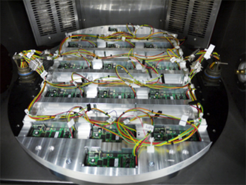
The company staff jointly decided that they should focus on the high-end commercial UAV market, so there had to be significant investment in production and development processes. Early on, an automated sensor calibration system was developed, which has recently been upgraded to use a two-axis rotating temperature chamber. This system allows MicroPilot to load up a couple dozen autopilots, and a few hours later fully calibrated and tested autopilots emerge! So, peak demand is readily accommodated, and MicroPilot staff is able to focus on product and process improvement rather than on labor-intensive manual testing.
The professional market is a more challenging customer base because customers fly much more expensive vehicles. While there is currently a lot of focus on low-cost hobby autopilots, these are seen as an interim step until there are proper regulations. In the end, UAVs are aviation products, and for many applications they require a high level of reliability and availability. No one is going to be flying 55-pound helicopters over a city without an autopilot that has undergone vigorous validation and verification processes. MicroPilot autopilots have a large number of options that enable configuration of the control system for the type of vehicle — for instance, fixed wing, multi-rotor, helicopter, or aerostat/blimp. Once the type of vehicle has been selected, the gains of the various feedback loops that control the vehicle are configured. There are also quite a few options for payloads and other onboard devices such as transponders and cameras.
MicroPilot is based in Winnipeg, Manitoba, Canada. The city is large enough to have a pool of talented engineering and computer science graduates. While the winter climate can be quite harsh, the city is not so large that there is much trouble finding a place to test fly. The MicroPilot facilities are about six miles outside the city, and the staff is able to test fly right outside their building under a Transport Canada special flight operations certificate. MicroPilot has 27 employees, ships in the order of 1,000 autopilots per year, and has 850 customers in 70 countries.
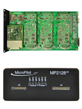
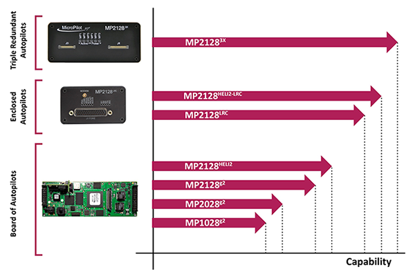
Regulation is the key to moving the commercial UAV market forward — a huge market is already flying sophisticated, expensive sensor payloads over cities. Even a moderate-size Multirotor UAV poses some safety risks, and it is important that regulators quickly devise rules to allow safe flight of these sensors over populated areas. MicroPilot has been working on improving its product offerings so that when regulations finally appear, the company will have products with the right capability and implemented correctly, so regulators should be able to readily establish that its products are safe. To this end, the first triple-redundant autopilot was introduced four or five years ago. It is still the only triple-redundant UAV autopilot available. Triple redundancy implies that two out of three channels could totally fail, and no failure will carry over from one channel to another, so autopilot functionality for the vehicle would still be maintained.
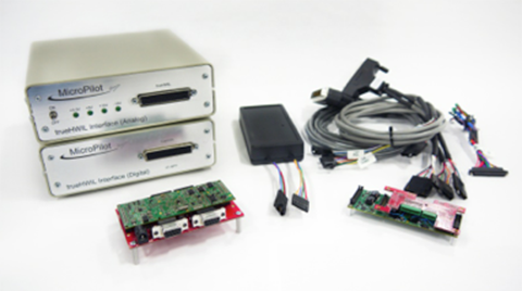
trueHWIL is a high-fidelity simulator that MicroPilot has developed where the sensors are stripped from the autopilot and the sensor inputs are simulated electrically. The simulator also reads control-position information from the autopilot. Under this simulator, the autopilot receives sensor data as if it is in the air. The code paths that the autopilot software executes are identical to those in a real autopilot in flight. Customers use this tool to build “iron-bird” simulations of the vehicle on the ground to validate the configuration prior to flight. It enables week-long or longer instrumented flight tests to be performed that would be difficult or dangerous to perform in real life.
trueHWIL high fidelity simulator. Photo: Micropilot
Finally, the xtender validate product has been developed. This requirements capture system allows customers to link system requirements to autopilot or ground control system (GCS) settings. It also allows the system designers to develop electronic flight-test cards linked to requirements. After flight test, the resulting data logs can be linked back into the xtender validate database and will also be automatically linked to the requirements used to define the flight-test card. This simplifies the flight-test process and allows managers to see that the system requirements have been completely exercised by flight testing.
MicroPilot integrates a number of different GPS receivers into its autopilots, including Trimble, u-blox and Novatel.
Sky Sapience in Israel has developed a unique HoverMast-100 solution for short-range, over-the-horizon reconnaissance. This UAV on a tether requires a high level of stabilization, which the MicroPilot autopilot enables. The tether allows for deployment up to a height of 50 meters within seconds, and the UAV can carry a 13-pound payload for a video camera, IR sensor, laser rangefinder, RF relay or other sensor — real-time data is transmitted to users over a wideband radio link. Armed forces in the United States, Israel and Asia are using the HoverMast-100. Commercial applications include power-line inspection, oil and gas pipelines, security, perimeter security, oil rigs, boats, agriculture, communication, sports events and disaster relief.
MicroPilot’s customer base is worldwide, with almost 1,000 different organizations having dealt with the company over the years. The range of applications goes from researchers flying a very odd vehicle with the ailerons split into a dozen segments (each controlled separately) all the way to customers using the system for traditional intelligence, surveillance, and reconnaissance (ISR), such as Bluebird Aero Systems. There are also customers that make multi-rotors (the proS3 in Italy) for a variety of data-collection needs; customers that fly targets (Avartek of Finland); customers that fly helicopters for video filming and emergency responders (Bertin in France and Helicam Pro in Italy); and customers that use UAVs in aerostats (Top I Vision in Israel). There are also a bunch of universities doing research using UAVs, and a couple of customers flying turbine powered UAVs.
So, for a significant number of UAV manufacturers and operators spread around the world, MicroPilot has become the supplier they rely on for autopilot solutions. And with the FAA now issuing what seems to be daily exemptions that allow commercial use of UAVs, it’s good to know that at least one autopilot supplier is already working towards the reliability and availability that certified applications of these vehicles will ultimately require.
Zano is a portable aerial photography and video platform designed for consumers that measures 65 x 65 millimeters and weighs 55 grams. Torquing Group, who is developing Zano with the help of a successful Kickstarter campaign, said that Zano’s ability to fly autonomously will provide new possibilities for users seeking to capture images and videos. The drones can even be programmed to swarm.
India-based GNSS device maker Stesalit has introduced a SXgeoCloud mobile mapping application. SXgeoCloud provides a full GIS data collection suite with active sync to leading enterprise GIS systems through a mobile and cloud architecture. SXgeoCloud will be available with the Sxtreo series of GPS/GNSS devices from Stesalit and is now available only to customers in India.
SXgeoCloud is compatible with all the SXtreo rugged GNSS field computers and other field GNSS devices. SXgeo is the offline mobile GIS software suite from Stesalit.
The Android-based mobile mapping system of SXgeoCloud supports over 50 OGC compliant formats and background raster Web Mapping Services. It allows users to acquire geospatial data including points, lines and polygons, along with their attributes with the advantage of creating new objects in the field. It supports all editing features and is flexible for users to work on offline and online basis with active sync to the SXgeoClould Server.
The cloud server of SXgeoCloud combines project creation, data-collection management, active sync, and archival. Data sets acquired or new objects created in the field are automatically updated in the cloud GIS server in real time, and can be actively synced with the user’s enterprise GIS in real time. Users can customize the data-capture properties, attributes, and forms to match their own enterprise database requirements. With SXgeoCloud, integration with industry-leading GIS server systems is seamless.
SXgeoCloud ensures consistently high-quality data import and export in a variety of GIS and CAD formats, increasing field work efficiency, productivity and the accuracy of GNSS data.
Trimble announced today a new version of its Trimble Positions software suite. This new version includes automated workflows to streamline data collection and increase productivity for GIS professionals in a variety of industries such as utility companies, environmental management agencies and municipalities.
With Trimble Positions, GIS professionals benefit from increased productivity through a streamlined and integrated workflow for managing GNSS data collection. Trimble Positions is a collection of Esri software extensions that provide high-accuracy capabilities on the Trimble GeoExplorer, Juno, and Yuma series of field handheld computers, and on Trimble Pro series receivers. Positions software enables high-accuracy GNSS collection on Trimble devices while using familiar Esri workflows to ensure data integrity. New automated workflows in the software further simplify data processing and management, Trimble said.
The latest version of Trimble Positions includes:
Automated Session Processor: Optimizes easier, faster GNSS session data processing with a stand-alone tool to perform automated check-in, postprocessing and feature updates.
Project Wizard: Saves time and avoids errors by guiding users through a step-by-step project set-up featuring streamlined administration screens.
ArcGIS Online Hosted Features Services: Gives users the ability to select ArcGIS Online hosted feature services as a data source allowing them to directly pull their project data from ArcGIS Online into their field collection projects.
Trimble Enhanced GPS Device Support: Positions software is now compatible with the Trimble Juno 5 enhanced GPS handheld and Yuma 2 enhanced GPS rugged tablet for increased choice of device and accuracy level that can be achieved.
Mean Sea Level Heights: Provides greater flexibility by including an option to utilize a geoid model for measuring heights, in addition to the existing ellipsoid model option.
Integration with TerraFlex Software: Saves time by streamlining data transfer between TerraFlex mobile data collection software and ArcGIS for Desktop. This feature integrates the TerraFlex Desktop add-in with the Trimble Positions Desktop add-in to remove the need for separate installations. In addition, fast and easy interoperability is enabled through TerraFlex projects support in the Positions project wizard.
Support for Trimble RTX technology-enabled Geo 7X handhelds: Provides autonomous, real-time submeter positioning in cellular environments with access to Trimble RTX services for Geo 7X users.
“Our customers expect high-quality data, and we need to give them the most efficient means of collecting and managing that data too,” said Alain Samaha, business area director of GIS and Software for Trimble’s Geospatial Division. “Trimble Positions software was specifically developed to meet the needs of our customer that utilize Trimble GNSS devices and Esri workflows. We understand our customers have different requirements and the Trimble Positions solution delivers to meet their needs.”
The Trimble Positions Desktop Add-In, Mobile Extension, Mobile Project Center and Session Processor are available now through Trimble’s authorized GIS Distribution Channel. The Trimble Positions ArcPad Extension is expected to be available in mid-January 2015.
Trimble has introduced a new portfolio of time and frequency products to address the synchronization needs of the growing LTE small cell market.
The products are designed for a wide range of small cell synchronization applications. The products provide increased holdover capabilities and more robust signals with multi-constellation GNSS technology to sync wireless networks more efficiently, Trimble said.
Regardless of whether a network is using 3G, 4G LTE, LTE-Advanced wireless technologies or a combination, synchronization and syntonization are essential for mobile networks. The new LTE-Advanced features — such as Enhanced Inter-Cell Interference Coordination (eICIC), Coordinated Multipoint Transmission (CoMP), Carrier Aggregation (CA) and Multi-Media Broadcast over a Single Frequency Network (MBSFN) — require an even higher degree of precision. Carriers are making significant investments in small cells, LTE-A and Heterogeneous networks to increase capacity and coverage. Network synchronization is a must to achieve both objectives, Trimble said.
The Mini-T GG Disciplined Clock is a multi-GNSS (GPS and GLONASS) embedded module, optimized to generate precise 10MHz output and pulse per second. It utilizes the latest in GNSS technology, combined with a precision ovenized oscillator for near-atomic-clock precision timing. The Mini-T GG provides 24-hour holdover capability and is suitable for pico and microcells.
The Trimble 360 multi-GNSS receiver is designed to cover the full spectrum of small cells — residential femtocell to rural microcell. The Trimble 360 timing products support GPS, GLONASS and BeiDou systems, and are Galileo-ready. In addition to full constellations, the 360 products support Satellite-Based Augmentation Systems (SBAS) and the Asian Pacific Quasi-Zenith Satellite System (QZSS).
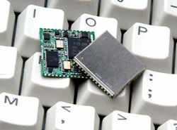
The compact, surface-mount ICM SMT 360 timing module, measuring 19 x 19 mm, generates a precise 10MHz reference clock for synchronization of residential and enterprise femtocell networks. It provides holdover capability, which allows the module to extend the availability of reference timing outputs. The Resolution SMT 360 is available in the same 19 x 19 mm form factor, and provides a pulse per second that provides nanosecond accuracy to any application requiring precision time reference such as wireless networks, utilities and digital broadcasting.
The Trimble Mini-T GG disciplined clock, ICM-SMT 360 module and Resolution SMT 360 timing module and starter kit are available now. The Trimble 360 multi-GNSS receiver is expected to be available in January 2015.