The first navigation signal transmission from the fifth Galileo satellite, one of two Full Operational Capability satellites launched into wrong orbits on August 22, was received today.
Stations of the Cooperative Network for GNSS Observation (CONGO) and the International GNSS Service Multi-GNSS Experiment (MGEX) network tracked an E1 signal with a PRN code of E18 this morning. The signal was first tracked at the La Laguna station (LLAG, Tenerife, Canary Islands) at 06:08:00 UTC.
A few moments later, the satellite was also tracked at the Geodetic Observatory Wettzell (WTZ3, Wettzell, Germany) and at the University of New Brunswick (UNBD, Fredericton, Canada). The receivers at all three stations are JAVAD GNSS Triumph receivers.
Analysis of current Galileo satellite visibility at various tracking stations confirms that the active satellite is GSAT0201, also known as Galileo FOC-FM1 or Galileo 5, with COSPAR ID 2014-050A and NORAD ID 40128.
As reported earlier, the perigee of Galileo 5’s orbit was raised in an effort to make the satellite usable for research, at least, and potentially for positioning and navigation.
What a difference eight years can make! My September 2006 GPS World article “Managing the GPS Constellation for Today’s Needs” dealt with GPS performance issues many high-precision users then faced. Demanding applications of real-time precision positioning, such as precision agriculture and machine control, did not find enough satellites in view to support their needs.
I posed the question: Is the problem with the number of usable GPS satellites, or with growth in the demands of the user community? The 2006 answer was: a little bit of both.
Now the issue has pretty much gone away. Users have adapted to incorporating other GNSS signals, initially GLONASS and now BeiDou. Russia’s commitment to operate GLONASS at full capacity developed into today’s operation of its 24-satellite constellation. China’s similar declaration led to deployment of 16 satellites to date toward an eventual constellation of 35. Europe is likewise poised to offer global services with Galileo. GPS’s days as the sole provider of ubiquitous, accessible services appear to be over.
One of my 2006 recommendations was for GPS decision-making authorities to support an aggressive program to replace aging satellites. This has been done. GPS went from one IIR-M satellite in 2006 to the present seven IIR-M satellites and seven IIFs. They provide a new civil signal on L2C, and the IIF provides a new civil safety-of-life signal on L5.
Let’s look at the differences in service between 2006 and 2014 as shown in Table 1. GPS RMS user range error (URE) has been cut in half, and the number of usable GNSS satellites has gone up by 39 percent (44 to 61).
Table 1. Differences in GPS service between 2006 and 2014.
Today GPS and GLONASS operate at full capacity. GPS exceeds its marks by providing 31 satellites broadcasting signal-in-space range errors in the half-meter range, even as Block IIF satellites add L2C and L5 signals. GPS high-precision users also employ space-based augmentation systems services such as WAAS, EGNOS, and QZSS. Internet-connected GPS receivers, including those in cellular phones, use Assisted-GPS to provide near instantaneous times to first fix.
One drawback to GNSS is its undependability when subjected to blockage, interference, or spoofing. GNSS services should be made more resilient, and PNT users must diversify their positioning sources. We are now moving into a hybrid world, in which PNT services go far beyond “just GPS” to multi-GNSS services augmented by other PNT technologies, including assisted GNSS, inertial sensors, and terrestrial positioning services. Although diversifying PNT sources increases cost, it may not be as much as some might think. At a recent PNT symposium at Stanford University, Greg Turetzky of Intel predicted even consumer-grade receivers used in automobiles, tablets, and smartphones will embrace all GNSS, despite the added cost in chip size and power.
Setting aside the larger PNT discussion and considering only GPS, what challenges must GPS address to remain the cornerstone of PNT services? Here is my list of the top issues GPS faces today.
Signal Vulnerability. Since the issue of GPS vulnerability was raised in the 2001 Volpe Report, this issue has not changed, but the stakes have risen much higher. There is greater dependence on the GPS service than ever before, with over a billion users. It is generally conceded that for many applications, reliance on GPS in its current form is insufficient and even risky. Brad Parkinson espouses the mantra of protect, toughen, and augment GPS, focusing on steps necessary to strengthen its service.
Numerous methods are being explored and implemented to protect and toughen GPS: increased signal power on modernized satellites, improved antennas, and authentication of the signal against spoofing. The U.S. Department of Transportation is actively seeking ways to protect GPS spectrum through public workshops on GPS adjacent-band compatibility.
The GPS civil signal remains open to malignant spoofing by nefarious forces. Various methods are being proposed to counter this threat. It may seem that adding signal authentication is a bit too late, since civil GPS signals have already been defined in interface specifications, but it turns out this may not be the case. At the Stanford Symposium, Col. Matt Smitham of the GPS Directorate stated that now is a good time to play with the civil navigation message implementations to explore features like authentication. “This is the time to do this, change the message types,” he said. Thus, there is an opportunity to counter this threat.
Gaps in Service. A low-power service that has limited operation in many settings, GPS does not provide full functionality at the Poles, nor does it work indoors or underwater. This issue is exacerbated by society’s demands for PNT services anywhere. The 2008 National PNT Architecture identified these gaps as a primary concern, encouraging numerous actions to resolve them.
Split Leadership. Although the Space-Based PNT Executive Committee and its National Coordination Office provide a mechanism for establishing high-level policy and providing outreach, they fall short of meeting other essential needs for acquiring, operating, and sustaining GPS. Funding for GPS is split between a number of departments and agencies including the DoD, DOT, the FAA, and NASA. The net effect is prioritization decided by individual departments and agencies, but not by the GPS leadership itself. Thus, some programs get funded by Congress, such as satellite and control system acquisition and the FAA’s NextGen program, but others do not. Civil signal monitoring and complementary PNT services to support increased PNT resilience have not been adequately funded. GPS operations experience the tragedy of the commons: GPS civil signal formats are defined but service standards and management protocols are not.
How to Manage GPS for Today
Resolve GPS vulnerabilities by strengthening the system and augmenting the service. Take the lead in addressing system vulnerabilities, including mitigating jamming and interference, and installing protections against spoofing. Hold forums on authentication means and methods, and fund research demonstrations using pre-operational civil signals.
Work to close the gaps in service. Implement reduced-cost-impact, easily accessible complementary technologies to fill GNSS gaps. Implement civil signal monitoring using alternative networks until the Next-Generation Operational Control System incorporates civil signal monitoring requirements.
Establish even closer cooperation between military and civilian leadership to provide unified funding, acquisition, and operations. Ensure a unified message to Congress for multi-agency funding needs. Work together to implement new civil signals, including operational protocols. Set dates cooperatively and meet them.
The GPS program produced a revolution in ubiquitous positioning, navigation, and timing that cannot be stopped. Care must be taken to ensure its services continue to benefit mankind while its vulnerabilities do not cause undesired harm to its users. With thoughtful planning and execution, GPS leaders will succeed.
John W. Lavrakas is president of Advanced Research Corporation, providing expertise in global positioning systems, having spent the past 34 years in GPS, working in its command and control, user operations, GPS receiver development, and satellite navigation performance analysis. He can be reached at [email protected].
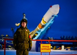
The second of two GLONASS-K1 satellites was launched from the snowy Plesetsk Cosmodrome on November 30 at 21:52 UTC. It joins the first GLONASS-K1 satellite launched on February 26, 2011.
According to the Roscosmos Information-Analytical Centre, the satellite, with serial number 12, is to be known by its in-orbit name of GLONASS 702. It is destined for orbital slot 9 in Plane 2.
The satellite will transmit five navigation signals in the L1, L2, and L3 bands. The satellite also carries a COSPAS/SARSAT transponder.
The satellite was launched on top of a Soyuz 2-1b booster. A statement from Roscosmos confirmed the 2,060-pound navigation satellite separated from the launcher in the correct orbit.
GLONASS-K satellites are designed to last longer, transmit more navigation signals, and launch on smaller rockets. Like the first Glonass K spacecraft, the second satellite will demonstrate new technologies that Russia plans to incorporate into GLONASS, according to Spaceflight Now.
Rollout:
Launch:
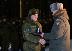
Gallery (photos from the Ministry of Defence of the Russian Federation.)
The orbit of one of the two Galileo satellites launched into incorrect orbits on August 22 is being adjusted. Tracking data supplied by the North American Aerospace Defense Command (NORAD) and the U.S. Joint Space Operations Center (JSpOC) has confirmed the change.
The satellites were supposed to go into circular orbits with an inclination to the equator of 56 degrees and with a semi-major axis of about 29,600 km. They ended up in eccentric orbits with semi-major axes more than 3,300 km shorter and with an inclination of about 49.7 degrees.
Instead of an orbital height of 23,222 km above the surface of the Earth, they were moving between apogee heights of about 25,900 km and perigee heights of about 13,800 km, perilously close to the most dangerous regions of the Van Allen radiation belts.
The European Space Agency announced on November 10 that the orbit of one of the two wayward satellites, Galileo 5, would have its perigee raised to 17,339 km through a series of 15 orbital maneuvers. This orbital adjustment would put the satellite into a safer orbit and potentially make it useable for positioning and navigation. If the operation is successful, Galileo 6 will follow suit.
These maneuvers likely started on or shortly after November 8. After the maneuvers began, NORAD/JSpOC temporarily “lost” the satellite as often happens when satellites undergo unpredicted Delta-V operations. NORAD/JSpOC recovered the satellite after about 18 days and issued new orbital elements for the satellite on November 25.
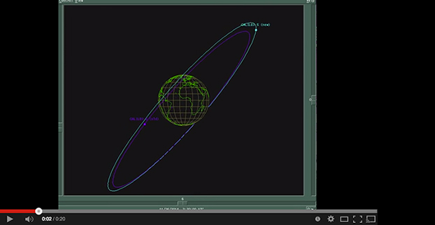
The new elements show that (so far) the perigee of Galileo 5 has been raised from about 13,820 km to 17,230 km with a corresponding change in the orbital eccentricity from about 0.23053 to 0.15619. The apogee height is virtually the same as that immediately after launch. Also, the inclination is not and will not be materially changed.
An animation, produced using the NORAD/JSpOC orbital element sets and the XEphem software, compares Galileo 5’s old and new orbits:
New data from the Federal Aviation Administration shows dozens of dangerous encounters around the country over the past six months, according to the Washington Post. Since June 1, commercial airlines, private pilots and air-traffic controllers have alerted the FAA to 25 episodes in which small drones came within a few seconds or a few feet of crashing into much larger aircraft. Many of the close calls occurred during takeoffs and landings at the nation’s busiest airports, presenting a new threat to aviation safety after decades of steady improvement in air travel.
Portland International Airport (PDX) is one airport that has experienced a surge in near-collisions with small drones, including several close calls as reported by pilots, reports KGW-TV. Oregon Senators Ron Wyden and Jeff Merkley called on the Federal Aviation Administration (FAA) to develop rules for drone technology.
According to KGW, one pilot was flying his Piper Archer II just south of downtown Portland on September 20 when a small drone buzzed by his private airplane at 3,000 feet. In another incident on July 7, a Hawker Beechcraft BE35 reported passing an unmanned aircraft while flying near PDX at 2,200 feet.
On September 11 and September 18, Port of Portland Police were notified by federal agents that someone was flying a drone 150-200 feet above their building. The FBI building sits just one-half mile from an airport runway. According to FAA reports, air traffic controllers at PDX could see the unmanned aircraft from the tower.
Also, FAA data shows two incidents involving drones were reported in Medford, Oregon, on September 27 and October 24.
u‑blox has announced the NEO-M8T and LEA-M8T precision timing modules, which are able to generate a precise reference clock with <20 ns accuracy. The receivers offer high sensitivity (-157 dBm signal acquisition with assisted GNSS) that allows quick start-up inside structures with limited sky view. The precise reference clock is derived from multi-GNSS including GPS, GLONASS, and BeiDou.
The LEA-M8T module is footprint compatible with existing LEA-5T/6T designs, facilitating easy upgrade. The NEO-M8T is optimized for timing applications requiring low power consumption and long battery life such as geophones used for seismic field measurements. Both compact, surface-mount modules meet stringent requirements for reliability, accuracy and low power consumption.
“These new modules are the industry’s highest performance GNSS timing modules in terms of accuracy, reliability and power consumption,” said Thomas Nigg, Vice President of Product Marketing at u-blox, “The new modules are perfect solutions for mission-critical infrastructure systems including mobile communication networks, power generation and distribution systems and seismic measurements.”
The NEO and LEA-M8T modules are multi-GNSS, pin-compatible successors to u-blox’ existing PPS timing modules and complements the previously announced GNSS disciplined frequency reference module, LEA‑M8F.
Measuring 12.2 x 16.0 mm (NEO-M8T) and 17.0 x 22.4 mm (LEA-M8T), the modules deliver high integrity and reliability with RAIM (Receiver Autonomous Integrity Monitoring) and alarms, which are crucial features for extremely reliable operation. Two time-pulse outputs are available, configurable from once per minute up to 10 MHz. The modules also output multi-GNSS RAW data including carrier phase, code phase and pseudo-ranges.
The modules can deliver time according to any international standard including calibration of inter-constellation offsets. Survey-in and single satellite timing features increase timing accuracy and timing availability with as few as one single satellite in view. Support for low duty cycle operation reduces power consumption for battery-powered applications which results in cost savings as smaller batteries can be used.
The M8T timing modules are delivered in u-blox’ established LEA and NEO form-factors with standardized pin-out, allowing ready migration from previous product generations. u-blox timing products can make optional use of u-blox AssistNow or industry standard aiding data. This reduces the time to first fix and delivers exceptional acquisition sensitivity, even on first installation before precise location or time is known.
The U.S. National Transportation Safety Board has ruled that drones are aircraft for the purpose of the Federal Aviation Administration’s prohibition of their careless or reckless use.
The NTSB affirmed the agency’s position that unmanned aircraft systems (UAS) meet the legal definition of “aircraft,” and that the agency may take enforcement action against anyone who operates a UAS or model aircraft in a careless or reckless manner.
The FAA appealed a decision by an NTSB Administrative Law Judge in Huerta v. Pirker, after the judge dismissed the FAA’s order requiring Raphael Pirker to pay a civil penalty of $10,000 for operating an unmanned aircraft in a careless or reckless manner at the University of Virginia in October 2011.
The FAA said in a statement, “The FAA believes Mr. Pirker operated a UAS in a careless or reckless manner, and that the proposed civil penalty should stand. The agency looks forward to a factual determination by the Administrative Law Judge on the ‘careless or reckless’ nature of the operation in question.”
Commercial drones are currently banned in the U.S., except for certain exemptions like one announced in September for some TV and movie production companies, as reported by PC World. Amazon.com and Google have said they plan to use drones to deliver goods. The FAA is required by U.S. Congress to frame a “safe integration” plan for the commercial use of UAS by Sept. 30, 2015.
The NTSB was ruling in an appeal against an FAA order that imposed a fine of $10,000 on aerial photographer Raphael Pirker in October 2011 for flying recklessly a powered glider aircraft near University of Virginia at Charlottesville, Virginia. Pinker was said to have been hired to supply aerial photographs and video of the university campus and medical center. He had argued that his aircraft, which was described as an UAS, was in fact a model aircraft.
A U.S. government representative stated at an international satnav forum that mandating use of specific GNSS services for applications such as air-traffic control, freight shipments, emergency calling, and road tolling could violate the terms of World Trade Organization (WTO) agreements that many nations, including all six GNSS providers, have signed. Regional mandates already exist for Glonass in Russia and Beidou in China, and have been suggested and extensively discussed in Europe, as a way of stimulating the market adoption of Galileo receiver chipsets, thus recouping some of the massive public investment in the satnav system.
The presentation occurred during the 9th Meeting of the International Committee on Global Navigation Satellite Systems (ICG), November 10–14 in Prague, the Czech Republic.
Jason Kim, a senior policy analyst at the U.S. Department of Commerce, stated that the United States and EU already enjoy a productive dialogue on GNSS trade issues under the 2004 U.S.-EU Agreement on GPS-Galileo Cooperation. In that agreement, both parties agreed to consult before establishing GNSS standards, certification requirements, regulations, mandates; affirmed their non-discriminatory approach with respect to GNSS trade; and established a working group to consider non-discrimination and other trade related issues. Finally, the United States and the European Union recognized and reiterated in 2004 their commitments to WTO rules including those governing technical barriers to trade (TBT), specifically, that there would be no goods discrimination based on non-tariff measures such as regulations, standards, testing, or certification.
Kim made the remarks in the course of his presentation titled “GNSS Market Access.” He told GPS World that his presentation was directed less at the European Union, which has been conscientious of its WTO commitments, and more towards the rest of the ICG members, including non-provider nations that may be asked by GNSS providers to mandate specific systems..
“To promote adoption of their systems,” Kim stated, “GNSS providers are considering/implementing equipage mandates for various applications: aviation, motor-carrier and HAZMAT vehicle tracking, car accident reporting (eCall/ERA-GLONASS), and emergency phone calls (E112).
“The United States recommends technology-neutral, performance-based standards,” Kim continued, giving as example the U.S. E911 rules that specify a required positioning accuracy and then allow wireless carriers to choose the best technical solutions according to their lights.
The U.S. government presentation at ICG revealed particular concern that regulations under consideration could adversely affect the sales of U.S. GPS-enabled hardware in many industry sectors. All members of the WTO, to include the six GNSS providers on the ICG, are bound to a range of trade agreements designed to promote open market access, all cited in the Prague ICG presentation: the General Agreement on Tariffs and Trade (GATT), the Agreement on Technical Barriers to Trade (TBT), and the General Agreement on Trade in Services (GATS). The United States, Europe, Japan, and 12 others are also parties to the WTO Agreement on Government Procurement (GPA).
European Commission officials have publicly and recently stated that they are considering how to stimulate Galileo use, in particular through regulatory measures requiring that navigation equipment be installed on aircraft, automobiles, and other platforms.
“Requiring specific systems arbitrarily prevents or penalizes imports of goods having perfectly functional GNSS capability,” said Kim. “WTO members must comply with TBT obligations in setting technical regulations.”
He concluded his presentation by requesting that the ICG Providers’ Forum add GNSS market access to its future agenda for discussion, and consider developing a new principle on market access for future adoption.
The ICG, an organization established in 2005 under the umbrella of the United Nations to discuss GNSS to benefit people around the world, “promotes voluntary cooperation on matters of mutual interest related to civil satellite-based positioning, navigation, timing, and value-added services. The ICG contributes to the sustainable development of the world. Among the core missions of the ICG are to encourage coordination among providers of global navigation satellite systems (GNSS), regional systems, and augmentations in order to ensure greater compatibility, interoperability, and transparency, and to promote the introduction and utilization of these services and their future enhancements, including in developing countries, through assistance, if necessary, with the integration into their infrastructures. The ICG also serves to assist GNSS users with their development plans and applications, by encouraging coordination and serving as a focal point for information exchange.”
Ultra-Low-Power, High-Accuracy Location for Wearable GNSS Devices: From Host-Based to On-Chip
Photo: Steve Malkos, Manuel del Castillo, and Steve Mole, Broadcom Inc., GNSS Business Unit
As location penetrates smaller and smaller devices that lack memory and computation power, GNSS chips must reacquire the standalone capability that they shed when first going to small form factors such as phones. A new chip with a new architecture demonstrates navigation and tracking and avoids burdening its main processor with heavy software.
By Steve Malkos, Manuel del Castillo, and Steve Mole, Broadcom Inc., GNSS Business Unit
End users first experienced the amazing capabilities of GPS 12 years ago with early mass-market GPS devices. The focus was on navigation applications with specific tracking devices like personal navigation devices and personal digital assistants (PNDs, PDAs). With the advent of smartphones, GPS became a must-have feature. Other constellations were added to improve performance: GLONASS, QZSS, SBAS, and very recently, BeiDou. In the current phase, the focus is shifting to fitness applications and background location. This is not an insignificant change.
Always-on connected applications, high-resolution displays, and other such features do not improve battery life. This article describes new ultra-low-power, high-accuracy location solutions for wearables’ power consumption.
Impact of Always-On Connected Applications
New applications require frequent GNSS updates with regard to user position. Sometimes the application will be open and other times it will not. The chips need to keep working in the background, buffering information and taking predefined actions. The GNSS chips need to be able to cope with these new requirements in a smart way, so that battery life is not impacted. Saving power is now the name of the game.
Furthermore, GNSS is penetrating small devices: the Internet of Things (IoT) and wearables. They do not have the luxury of large resources (memory, computation power) as smartphones do. GNSS chips cannot leverage the resources in those devices; they need to be as standalone as possible. In summary, the new scenario demands chips that:
do not load device’s main processor with heavy software;
use less power while maintaining accuracy;
can be flexibly configured for non-navigation applications.
New GNSS Chip Architectures
The industry is designing chips to meet these requirements by including the following features:
measurement engine (ME) and positioning engine (PE) hosted on the chip;
accelerometer and other sensors directly managed by the chip;
new flexible configurations, duty cycling intervals, GNSS measurement intervals, batching, and so on.
These features require hardware and software architectural changes. The new chips need more RAM than that required for smartphones, as they must now host the ME and PE. Wearables and IoT devices are small, cheap, and power-efficient. They do not have large processors and spare memory to run large software drivers for the GNSS chip. In many cases, the device’s microcontroller unit (MCU) is designed to go into sleep mode if not required, that is, during background applications. Therefore, new GNSS chips with more RAM are much better adapted to this new scenario.
New chips must tightly integrate with sensors. The accelerometer provides extremely valuable information for the position update. It can detect motion, steps, motion patterns, gestures, and more. However, as a general rule, the MCU’s involvement in positioning should be minimized to reduce power consumption. For power efficiency, the new GNSS chips must interface directly with the sensors and host the sensor drivers and the sensor software.
Finally, new chips must adapt to different human activities as they are integrated into wearable devices. This is the opposite approach from past developments where GNSS development was focused on one use case: car navigation. Now they must adapt to walking, running, cycling, trekking, swimming, and so on. All these activities have their particularities that can determine different modes in which new GNSS chips can work. Electronics must now conform to humans instead of the other way around. New wearable-chip GNSS tracking strategies include dynamic duty cycling and buffering, which contribute to the goal of reducing power consumption without compromising accuracy.
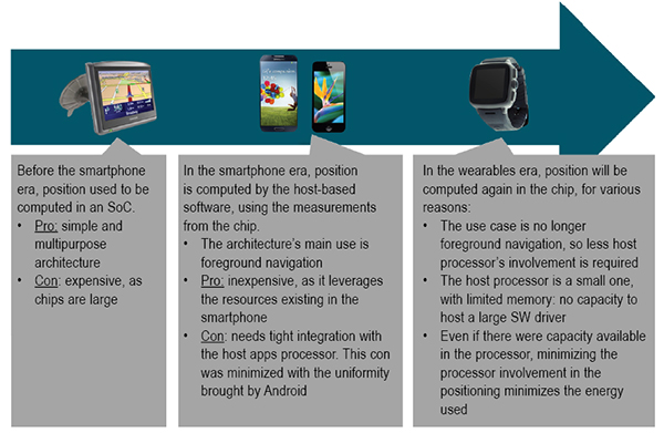
Satellite positioning embedded in devices over the last few years first saw on-chip positioning before the era of smartphones, where you had dedicated SoCs that supported the silicon used to compute the GNSS fix. These expensive chips had lots of processing power and lots of memory. Once GNSS started to be integrated into cellphones, these expensive chips did not make sense. GNSS processing could be offloaded from the expensive SoCs, and part of the GNSS processing was moved onto the smartphone application processor directly.
Since navigation is a foreground type of application, the host-based model was, and is still, a very good fit. But with advances in wearable devices, on-chip positioning will become the new architecture. This is because the host processor is small with very limited resources on wearables; and because energy must be minimized in wearables, reducing the processor involvement when computing GNSS fixes is critical.
Some vendors are taking old stand-alone chips designed for PNDs and repurposing them for wearable devices. This approach is not efficient, as these chips are large, expensive, and use a lot of power.
GNSS Accuracy
While the new fitness and background applications in wearables have forced changes in GNSS chips’ hardware and software architectures, GNSS accuracy cannot be compromised. Customers are used to the accuracy of GNSS; there’s no going backwards in performance in exchange for lower power consumption.
Figure 1. Software architecture for wearables.
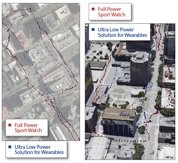
A series of tests shown here demonstrate how a new wearable, ultra-low-power GNSS chip produces a comparable GNSS track to existing devices using repurposed full-power sportwatch chips, while using only a fraction of the power.
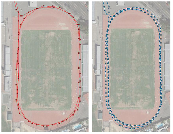
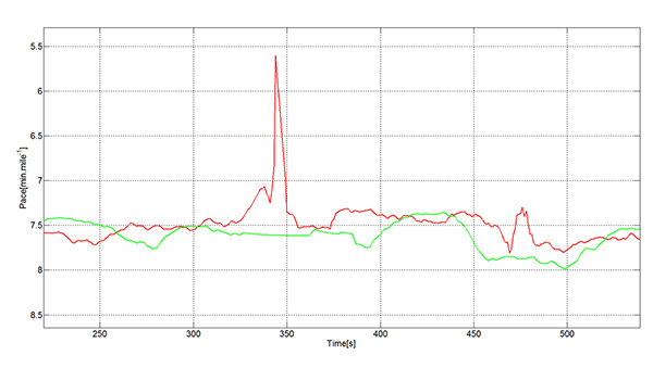
Speed Accuracy. Not only does the ultra-low-power solution produce a comparable GNSS track, it actually outperforms existing solutions when it comes to speed and distance, thanks to close integration with sensors and dynamic power saving features (Figures 2 and 3).
Figure 2. Ultra-low-power versus full power.Figure 3. Full-power sportwatch, left, and ultra-low power chip, right, in more accuracy testing.
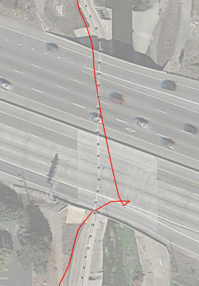
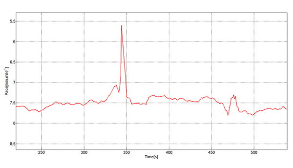
GNSS Reacquisition. GNSS-only wearable devices face a design challenge: to provide complete coverage and to avoid outliers. This is seen most clearly when the user runs or walks under an overpass (Figure 4). Familiar to urban joggers everywhere, the underpass allows the user to cross a busy road without needing to check for traffic, but requires the GNSS to reacquire the signals on the tunnel exit. See the GNSS track in Figure 5: when the device reacquires the signals, the position and speed accuracy suffers.
Figure 4. Position accuracy on reacquisition, emerging from overpass.Figure 5. GNSS speed accuracy on reacquisition.
Using the filtered GNSS and sensors, however (Figure 6), enables smooth tracking of speed and distance through the disturbance.
Figure 6. Sensors provide smooth speed estimate.
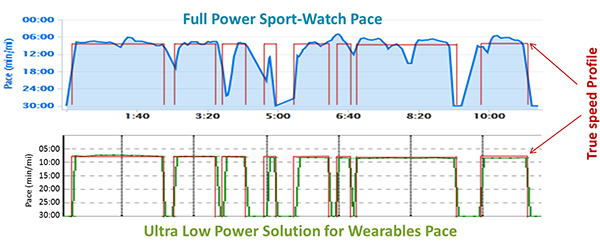
Urban Multipath. The pace analysis in Figure 7 shows a user instructed to run at a constant 8-minute/mile pace, stopping to cross the street where necessary. The red line on each plot shows the true pace profile. The commercial GNSS-only sportwatch on top shows frequent multipath artifacts, missing some of the stops and, worse for a runner, incorrectly showing erroneously high pace. The ultra-low-power chip captures all the stops and shows a constant running pace when not stopped.
Figure 7. Urban multipath tests.
It is well known in the community that regular sportwatches give unreliable speed and distance estimates in urban environments — where most organized running races are held! There’s nothing worse, as a runner, than to hear the distance beep from your watch going off earlier than expected: how demoralizing! The major benefit of this solution is that the speed estimate is much more reliable in the presence of multipath. At the same time, battery life can be extended because the GNSS is configured to use significantly less power.
fSpeed in existing solutions is computed in two different ways: indirectly from two consecutive, time-stamped GNSS position estimates, each derived from range measurements to the satellites, and directly from the Doppler frequency offset measurements to the satellites. Both range and frequency measurements are subject to significant error when the direct path to the satellite is blocked and a reflection is acquired.
The effects of multipath mean that the range error may in typical urban environments be hundreds of meters. The frequency error is also a function of the local geometry and is typically constrained by the magnitude of the user’s horizontal speed.
In either case, the GNSS device alone, in the presence of signal multipath, generates a velocity vector that fluctuates significantly, especially when there is a change in the satellites used or signal propagation path between the two consecutive positions. A variety of real-life cases generate this sudden fluctuation in velocity vector:
Running along a street in an urban canyon and turning a 90-degree corner.
Running along a pedestrian lane and taking a short road underpass.
Running under tree cover and suddenly arriving at an open area.
Running under an elevated highway and turning 90 degrees to a wide-open area.
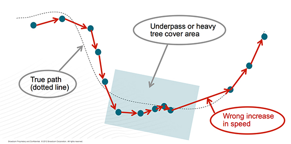
In each case, the chips are using a certain set of satellites, and suddenly other, higher signal-strength satellites become available. A typical situation is for the position to be lagging the true position (while under tree cover, going through an underpass) and needing to catch up with the true position when arriving to the wide-open area. A jump in position is inevitable in that situation. This is not too bad for the GNSS track, but it will mean a noticeable peak in the speed values that is not accurate. Fitness applications save all of the computed speed values and generate a report for each workout. These reports are not accurate, especially the maximum speed values, for the reasons explained above.
Figure 8 describes a typical situation where the actual speed of the runner is approximately constant. GNSS fixes are computed regularly; however, the speed computed from subsequent GNSS fixes have sudden peaks that spoil the workout speed reports.
Figure 8. Sudden peaks spoil workout speed reports.
The new ultra-low-power solutions for wearables solve this problem by deriving speed and accumulated distance from the sensors running in the device. This avoids incorrect speed peaks, while still being responsive to true pace changes by the runner.
In running biomechanics, runners increase pace by increasing step cadence and/or increasing step length. Both methods depend on the runner’s training condition, technique, biomechanics, and so on. As a general rule, both step cadence and step length increase as the running speed increases from a jogging speed to a 1,500-meter race speed.
A runner may use one mechanism more than the other, depending on the moment or on the slope (uphill or downhill). In the case of male runners, the ratio of step length to height at a jogging speed is ~60 percent.The ratio of step length to height in a 1,500 meter race speed is ~100 percent. For female runners, the respective ratios are ~55 percent and ~90 percent.
The ultra-low-power chips take into account both mechanisms to derive the speed values. The sensor algorithms count the number of steps every time interval and translates the number of steps into distance multiplying by the step length. The reaction time of the GNSS chip to speed changes based on a higher cadence is immediate.
Speed changes due to longer steps are also measured by the ultra-low-power chips. The step length is constantly calibrated by the GNSS fixes when the estimated GNSS position error is low. The reaction time of the GNSS chip to speed changes based on longer steps has some delay, as it depends on the estimated error of the GNSS fixes.
Manufacturer
The ultra-low-power, high-accuracy, 40-nanometer single-die BCM4771 chip was designed by Broadcom Corporation. It is now being manufactured in production volumes and is focused on the wearables and IoT markets.It consumes five times less power than conventional GNSS chips (~10 mW) and needs 30 KBytes of memory in the MCU for the software driver. It features tight integration with the accelerometer and innovative GNSS tracking techniques for extremely accurate speed, accumulated distance, and GNSS tracking data.
Steve Malkos is an associate director of program management in the GPS Business Unit at Broadcom, responsible for defining GPS sensor hub and indoor positioning features. He has a B.S. in computer science from Purdue University, and currently holds eight patents,10 more pending, in location.
Manuel del Castillo is an associate director of marketing for Broadcom in the GNSS group. He has an MS in electronic engineering from the Polytechnic Universityand an MBA from the Instituto de Empresa, both in Madrid, Spain. He holds three patents in location with five more pending.
Steve Mole is a manager of software engineering for Broadcom in the GNSS group. He received his bachelor’s degree in physics and astrophysics from the University of Manchester.
Esri is offering a Severe Weather Public Information Map that charts instances of severe weather throughout the United States and Canada. Weather events tracked include snowstorms, tornadoes, floods, hail storms, wind storms, and short-term weather warnings issued by the National Oceanic and Atmospheric Administration (NOAA).
The map features live feed layers. Users can click on reports and warnings to receive information about the specific location and read a short description about the issue. Radar is provided by AccuWeather and Environment Canada as part of the Esri Disaster Response Program.
CSR has added significant upgrades to its SiRFDRive software dead-reckoning algorithms, improving automotive positioning performance and meeting the requirements of leading OEMs across the globe. This video demonstrates how these latest algorithms improves the overall performance in Chicago, once of the most challenging environments to obtain accurate vehicle positioning results.