Telefónica and Geotab have announced an agreement to partner in Europe. The agreement will initially focus on the markets of Spain, Germany and the U.K., with the intention to explore Latin American markets in the near future.
The solution, which includes Geotab’s plug-and-play device, offers real time fleet management and the ability to develop a number of alerts, notifications, and review driver trip and activity reports. Advanced features also include on-board diagnostics through engine indicators to return feedback, such as engine failures, or an in-depth engine fault code diagnosis; detect accidents and retrace cause of the accident; and allow add-ons such as a navigational device, NFC driver ID key, sensors and more.
According to Geotab, the technology will help businesses improve their on-road productivity, on-road safety, and ecological efficiency, in addition to optimizing fleet performance to reduce fuel costs. Fleet managers will gain more intelligence across multiple vehicles giving them the data and insights needed to make more informed business decisions in real-time. Furthermore, drivers will have more insight over their individual vehicles.
Through this agreement, Telefónica extends its fleet management offer to further cover the global needs for its clients of both large corporations and small and medium size companies.
“We’re delighted to partner with Geotab, who through continuous innovation have many of the world’s largest fleets already using their product,” said Surya Mendonça the m2m managing director at Telefonica. “This agreement allows Telefónica to provide a best-in-class ‘plug and play’ fleet telematics product in Europe that reinforces our portfolio and gives our m2m customers further access to the strongest solutions.”
“We are seeing tremendous growth for fleet management solutions worldwide and the wireless carriers are now becoming an integral component of the fleet telematics and connected machine ecosystem. We are impressed by the Telefonica m2mteam and look forward to working together with Telefonica to deliver the most advanced fleet telematics solution in the market,” said Neil Cawse, CEO of Geotab.
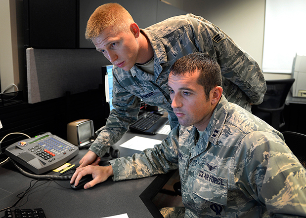
Capt. Jared Delaney, 19th Space Operations Squadron satellite vehicle operator, right, and Senior Airman Bryan Wynkoop, 19 SOPS satellite system operator, monitor telemetry during the GPS SVN-69 launch Oct. 29, 2014 at Schriever Air Force Base, Colo. (U.S. Air Force photo/Dennis Rogers).
The following story by Scott Prater appeared in the Schriever Sentinel, a weekly newspaper published by the Colorado Springs Military Newspaper Group. See http://www.schriever.af.mil/units/publicaffairs/ for further information.
By Scott Prater Schriever Sentinel
11/19/2014 – SCHRIEVER AIR FORCE BASE, Colo. — It’s been a busy year for members of the 19th Space Operations Squadron. As operators of the GPS launch and early orbit, anomaly-resolution and disposal system, 19 SOPS members executed a historically high number of satellite launches (four), and disposed of a legacy GPS vehicle, all within the past 10 months.
“The last time we launched four vehicles in one year was 1993,” said Maj. Kimberly Adams, 19 SOPS LADO flight commander. “We’re looking forward to a more normal [operations] tempo, in the coming year.”
Tensions were high Oct. 29 during the lift-off and early-orbit of SVN-69, a GPS Block IIF vehicle, when a CBS news crew captured film footage of the event on the operations floor here.
“That was out of the ordinary for sure,” Adams said. “Compound that anxiety with the knowledge that we had just completed final configuration of a GPS vehicle disposal not 48 hours prior and you can understand the type of month October was for us and our 2nd Space Operations Squadron teammates.”
Senior Airman Bryan Wynkoop, 19 SOPS satellite system operator, wouldn’t change a thing about the past few months of 2014.
“It’s exciting,” he said. “This sure beats working a regular job. The drama and importance of what’s taking place here is exactly what I signed up for.”
Adams and Wynkoop are Air Force Reservists, as are all 19 SOPS members. The squadron falls under the Air Force’s 310th Space Wing, headquartered at Schriever AFB, and works in partnership with 2 SOPS, the 50th Space Wing unit responsible for commanding and controlling the GPS constellation.
Adams says 19 SOPS was stood up precisely to conduct GPS launches, manage anomalies and process disposals.
“We start preparing for launch about 90 days out,” Adams said. “With so many launches so close together, we often began preparations for one launch before the previous one was off the pad.”
Their partnership with 2 SOPS has proved beneficial for both squadrons.
“This most recent launch was my seventh and Airman Wynkoop’s sixth,” said Adams, who is in her fifth year at 19 SOPS. “Active-duty Airmen typically reside on station for roughly three years, so oftentimes our 2 SOPS teammates are looking to us to provide continuity and experience.”
That continuity became crucial during disposal operations for SVN-33. It had been more than two years since the two squadrons had disposed of a vehicle and Wynkoop was one of the few Airmen at Schriever who was familiar with the operation’s intricacies.
“These events don’t happen often, so to have played a role in two huge events was something special for all of us who were here,” he said.
Less than 48 hours after SVN-33 had been fully configured for disposal, SVN-69 was standing on the launch pad at Cape Canaveral, Florida.
Adams, Wynkoop and their fellow 19 SOPS operators’ day started eight hours prior to the launch.
“Wynkoop had to set up communications links with our antenna at the Cape so we could get telemetry data from the satellite,” Adams said. “Once the rocket lifted off, I was performing communications checks and verifying that we were meeting all of our requirements.”
Then they waited.
Three and half hours after launch, SVN-69 separated from its booster rocket.
“At that point we obtained an initial state of health from the satellite to ensure everything was OK and then we started commanding,” Adams said.
Wynkoop explained that though he and his teammates are actually studying telemetry data through their monitors on the operations floor, it’s easy to envision what’s happening in space.
“The vehicle is spinning once it separates from the booster,” he said. “We then issue commands to slow the spin and deploy the vehicle’s solar arrays, antennas and other critical components. Later, we get the vehicle in a condition known as sun safe. Shortly after, the vehicle acquires Earth and is in a stable orbit in the GPS slot where it’s supposed to be.”
Now, it’s up to 2 SOPS to command and control the satellite, one of 39 on orbit. The squadron expects to receive satellite control authority of the spacecraft later this month and the next GPS launch is scheduled for March 2015.
Hacking, Privacy, and Consumer Acceptance Top the List
Vehicle styling, speed and looks took the back seat while capabilities driven by GPS, sensors and data were up front at this week’s Los Angeles Auto Show’s Connected Car Expo. Privacy and security, distractibility and safety, and human interfaces were all hot issues. The terms connected car and autonomous cars were being used interchangeably, as a continuum of an evolving set of capabilities. The least-asked question: If we build an autonomous vehicle, will it sell or become an expensive niche product? And how will the market respond to mechanical failures or accidents, even if the vehicles are proved to be overall safer and more reliable?
Not Happy with Navigation. With little to individually distinguish car models, auto makers are looking to infotainment to uniquely brand their vehicles. Yet drivers identify navigation and multimedia among the “lower quality” features of their vehicles. While consumers report that the quality of almost all other features of their vehicles are improving, they indicate that the quality of their navigation and multimedia are declining. “The problem is overly complex systems,” reports Renne Stephens of J.D. Power. “Usability is now considered by consumers as a factor of quality.”
Car makers are under enormous pressure to add functionality demanded by consumers, and make the whole experience simpler. Many of the features embraced by automakers have not attracted the interest of drivers. Stephens reports that valued features include surround view camera with rear vision, wireless charging station, near field communication and smartphone field integration. What they don’t value are eye tracking, tactile touch screens, hand gesture control and laser headlights.
Hacking. Discussions on security were enlivened with the inclusion of hacker Chris Valasek. You may remember that last year Valasek and his partner, Charlie Miller, hacked into the steering and brakes of a Prius and Ford Escape, solely by attaching a laptop to the vehicles. Members of an Israeli intelligence unit reported that they had remotely hacked into a vehicle wirelessly via an aftermarket insurance dongle (in this case, Zubie) that was plugged into the vehicle’s OBDII port. Dongles might make people safer drivers, but could they lead to an unwanted adventure?
Valasek and Miller created a list of the most hackable vehicles with the Jeep Cherokee, Cadillac Escalade and Toyota Prius as the most vulnerable. The Dodge Viper, Audi A8 and Honda Accord top the most secure list. Malicious attacks could range from enabling a microphone to eavesdrop to the catastrophic, such as controlling steering or brakes.
Valasek assured conference goers that hacking vehicles isn’t easy. No matter how many layers of protection are created, no vehicle that communicates with the outside world will be hack-proof. Last month, automakers announced that they are forming a consortium that will be dedicated to deterring “black hat hackers” and will create a venue for the auto industry to share information about hacking attempts.
Dreams and Nightmares. The best-case scenario for the automotive OEMs is a connected vehicle industry in which they control the ecosystem and derive high revenues, as well as driverless cars starting to become common around 2024. In reality, the OEMS may encounter lagging consumer acceptance, perhaps shattered by catastrophic accidents, reliability issues or privacy troubles. Regulation might cause insurmountable constraints. The driverless car could become a niche product and a costly failure.
In another possible scenario, the connected autonomous vehicle becomes a success, but the tech and digital companies win the market with parallels similar to how the PCs took the industry from IBM. The OEMs become a pipeline with little value and the tech companies take home the bacon. If the market fails, the VCs will stop investing and some of these tech companies may fold. The Tesla offers an example of how this scenario might unfold.
Privacy. Automakers are making a commitment to privacy in the vehicle far beyond that made by companies like Apple or Google, which are vying for a piece of connected vehicles. Nineteen automakers just signed a set of principles delivered to the Federal Trade Commission. “Google may want to become an automaker, but we don’t want to become Google,” said Mitch Bainwol of the Alliance of Automobile Manufacturers. The OEMs provide assurance that they will not share information from vehicles that is streamed back to automakers or that is downloaded from the vehicle’s computers. They pledge information won’t be handed over to authorities without a court order, sold to insurance or other companies or used to bombard them with ads for Starbucks, gas stations or other businesses they drive past, without their permission.
“You just don’t want your car spying on you,” said Marc Rotenberg of the Electronic Privacy Information Center. “That’s the practical consequence of a lot of the new technologies that are being built into cars.” The automakers signing on to the principles are: Aston Martin, BMW, Chrysler, Ferrari, Ford, General Motors, Honda, Hyundai, Kia, Maserati, Mazda, Mercedes-Benz, Mitsubishi, Nissan, Porsche, Subaru, Toyota, Volkswagen and Volvo.
Uptake. About half of us like to drive and the other half just want to get there, reports futurist Peter Schwartz. Younger populations are increasingly in the transport camp, as illustrated by the popularity of Uber, Lyft and Zip Cars. How to win the whole market is to “automate the boring parts of driving,” says Håkan Samuelsson of Volvo.”
J.D. Powers reports that consumers perceive the autonomous vehicle as a driver completely detached from the driving experience. This isn’t too close to the reality that is within reach; the driver will need to be engaged and ready to assume control when called upon. But the dream of catching a few winks on the way to work is a good one. Will this vision be led by Detroit or Silicon Valley? We should find out soon.
Topcon Positioning Group has completed the acquisition of Wachendorff Elektronik GmbH and Wachendorff Electronics Inc. in a private transaction.
Wachendorff Elektronik GmbH and its U.S. subsidiary Wachendorff Electronics, Inc., are manufacturers of in-cabin mounted consoles for the industrial vehicle market in the agricultural and construction industries.
“This acquisition is a key ingredient of our global strategy to strengthen our ability to serve original equipment manufacturers (OEM) and establish the foundation for Topcon manufacturing in Europe,” said Ray O’Connor, Topcon Positioning Group president and CEO. “This world-class facility in Germany is second-to-none in its operational quality, employee dedication, and astute leadership — all of the characteristics needed to exceed the high-precision standards required for our industry.”
“This transaction is an example of our commitment to expand our portfolio of high-quality products and become the world’s leading provider of in-cab consoles for the agricultural and construction OEM markets,” said Albert Zahalka, president of Topcon Precision Agriculture and leader of the acquisition team.
The Wachendorff family founded Wachendorff Prozesstechnik GmbH & Co KG in Geisenheim, Germany in 1978. Wachendorff Elektronik was founded in 1985.
Buddy Platform, Inc., has launched its new platform that hosts and manages data generated by any connected device, enabling measurement of a device from the moment it’s turned on throughout its entire lifecycle. This data, often referred to as “telemetry data,” conveys information about the performance and usage of the device, and is now accessible from any common BI tool.
Buddy helps answer the question, “How is this device being used?” and “Is it performing like we designed it to?”. Buddy is live with customers in industries such as aviation, automotive (connected cars), retail, connected home, consumer electronics and embedded silicon.
While most connected or “Internet of Things” devices have functionality to enable control or monitoring (such as from a mobile app), relatively few are making performance and usage data accessible for analysis. By giving product management, engineering and support teams access to this data, and the insights that are derived from it, organizations can dramatically increase their ability to build better products and support the customers of these products in-market.
“Now that devices as varied as door locks, light bulbs, kiosks and cars are all becoming connected, there’s a huge amount of data that can give manufacturers exactly the information they need to support and improve their products,” said David McLauchlan, CEO of Buddy Platform. “Device manufacturers are not cloud infrastructure companies. They’ve built technology into their products to control the device, but haven’t built the infrastructure to access and use the device’s telemetry data to improve the product and delight customers. Buddy makes it fast and easy to access those insights and immediately understand more deeply how customers are using these kinds of IoT devices.”
Adding to the challenge is that the regulatory environment for data storage is becoming more complex. Various countries are enacting legislation that specifies how and where personal data may be stored.
Buddy works by hosting a series of regionally sandboxed, global BuddyAPI endpoints to which devices can send their raw telemetry data. This data is pushed into a secure storage infrastructure called BuddyVault, whereupon it is then managed, queried and exposed back to the customer in any form they wish with BuddyView. This may take the form of integrations into common business intelligence tools, or as raw APIs that can be plugged into any customer or M2M scenario.
With the addition of a few lines of code, the Buddy Platform offers a low overhead solution for extracting telemetry data from a device, and can make an unprecedented amount of device performance data broadly accessible to an organization, including:
How is this device being used? Is it performing like we designed it to, is it working as expected?
What error codes is my device reporting, and how is that affecting the customer experience?
How many of my devices are being used?
Where are they?
When are they used and how often?
Are they on or off?
How are my devices communicating with one another? If not, what’s not working?
How are my devices performing with connected ecosystems like smart homes or industrial infrastructure?
Buddy uses standard technologies including REST service over HTTPS, which means any device with Internet connectivity can use Buddy. There are no agents, no heavy runtime to install, and the platform offers access managed, queried subsets of the data, which are available via completely customized JSON APIs.
CSR plc today announced the launch of its SiRFusion Software Development Kit (SDK) for Android application developers. The solution enables indoor positioning for Android developers looking to create next-generation apps.
Developers can now leverage the SiRFusion library to rapidly integrate new location-based capabilities and services such as indoor location tagging and analytics for social networking applications, indoor navigation, lone worker efficiency and safety capabilities, as well as indoor asset tracking and targeted e-commerce services.
CSR is being acquired by Qualcomm, with the transaction expected to close by the end of the summer of 2015.
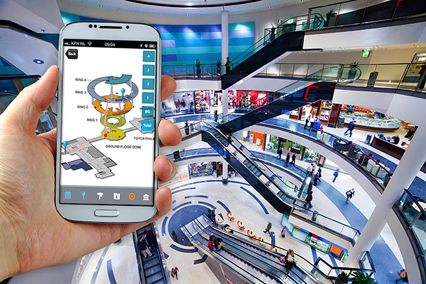
Mobile applications with integrated SiRFusion can now deliver the ubiquity of outdoor navigation to indoor environments without costly surveys or infrastructure upgrades. SiRFusion combines real-time Wi-Fi signals, satellite positioning information, pedestrian dead reckoning, and the company’s cloud-based CSR Positioning Center to calculate accurate indoor location. SiRFusion technology provides the accurate indoor position fixes needed to make continuous indoor navigation a part of everyday life. The system automatically crowd-sources a venue’s indoor Wi-Fi signatures as consumers walk through the location, and it has also been architected to accommodate future proximity and location technologies such as Bluetooth Smart beacons, Wi-Fi Round Trip Time (RTT), and Indoor Messaging System (IMES).
“Offering indoor positioning accurate enough to be useful has been a challenge that the industry has been trying to solve for many years,” said Anthony Murray, Senior Vice President, Business Group at CSR. “But with consumers coming to expect anytime-anywhere positioning wherever they are, our customers have continued to express a growing interest for accurate indoor positioning without the need for additional infrastructure. With our SiRFusion Software Development Kit, we have, for the first time, made indoor location a reality for developers who want to deliver innovative location-based products and services without proprietary infrastructure.”
SiRFusion for Android can be integrated into any app running on Android version 4.4 or later. The SDK will be available for download from www.csr.com in Q1 2015, and will include the SiRFusion library, API descriptions, and a Developer’s Guide. CSR will demonstrate SiRFusion for Android at the Location and Context World conference December 2-3, held at the JW Marriott in San Francisco, and at Consumer Electronics Show (CES) in Las Vegas January 6-9, 2015. To schedule a private briefing and demo at either event, contact [email protected]
Since the AT&T Drive Studio opened in January 2014, twelve companies have joined AT&T there in an effort to collaborate and develop new services for the connected car of the future. The latest company to join is LG Electronics, which signed on November 18.
AT&T Drive Studio is a connected car center for innovation and research. Its sponsorship agreement with LG allows the companies to collaborate on the AT&T Drive platform to support services on automotive-grade hardware and equipment for tomorrow’s connected vehicles.
Located in Atlanta, the more than 5,000-square foot AT&T Drive Studio features working garage bays, a speech lab, a full showroom to exhibit the latest innovations, conference facilities, and much more. Drive Studio integrates AT&T solutions across multiple companies and serves as a hub where AT&T can respond to needs of automotive manufacturers and the auto ecosystem at large.
“At the Drive Studio we work with automakers to make the in-car experience better and safer for the driver and passengers,” said Chris Penrose, senior vice president, Internet of Things Solutions, AT&T. “The spirit of the AT&T Drive Studio is to bring together players in the auto industry ecosystem, like LG, to design the road ahead.”
“By analysis of customer insights and Car OEM’s requirements, safety, comfort and convenience are key factors in automotive area,” said Jong Rak Lim, vice president and head of LG’s In-Vehicle Infotainment R&D Lab. “As global telematics supplier, we are very pleased to participate in AT&T Drive Studio as a sponsor and hope to bring better Connected Car solutions into the market together.”
AT&T already provides mobile Internet access in vehicles manufactured by both U.S. and non-U.S. automobile makers. AT&T entered the market with a proprietary, global SIM platform that made it possible for automotive, consumer and M2M equipment makers to work through a single carrier to wirelessly enable and connect products across the globe, and cars are being sold throughout world today with this SIM.
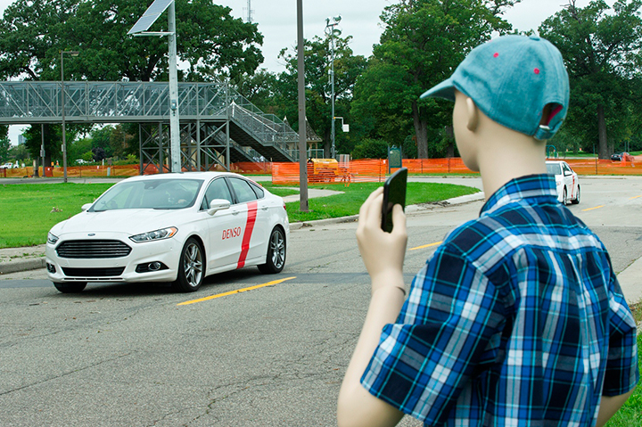
Denso Corp. began testing advanced driving support technology on a public road in Aichi Prefecture, Japan, this past June. Denso is testing automated driving scenarios in a single lane and testing automatic lane changes, as well as other driving maneuvers. Denso’s goal is to develop technologies that reduce driver workload and assist in safe driving.
Previously, Denso tested this technology on its test course in Japan. Denso’s goal with public road testing is to identify, analyze, and solve real-life problems that don’t occur on the test course.
Denso is conducting the field tests as part of activities led by the Vehicle Safety Technology Project Team to reduce traffic accidents. The project team is organized by the Aichi prefectural government and involves companies and organizations operating in the prefecture.
Denso has been developing its advanced driving assistance technology to achieve safer and more reliable driving while the driver remains in control of the vehicle. Development and commercialization of this technology will help prevent traffic accidents and contribute to increasing safety of our automotive society.
Denso Corporation, headquartered in Kariya, Aichi prefecture, Japan, is a global automotive supplier of advanced technology, systems and components in the areas of thermal, powertrain control, electronics and information and safety. Its customers include all the world’s major carmakers.
Testing involves automated driving on a single lane.Automatic lane changes are also being tested.
IAV Automotive Engineering test vehicle. Photo: Denso
The autonomous, or driverless, vehicle market seems to be a big side topic at connected car conferences. Location technology will continue to play a role in the development of autonomous vehicle markets. However, many view a fully autonomous vehicle to be more than 10 years away — these are usually folks from the auto industry or academia. Others, those who lurk around Silicon Valley, believe that driverless cars will be on the road in half that time…and once again, if Detroit doesn’t move on it, they will.
Just as GPS was once thought of as science fiction — something that naysayers said would not be fully operational for decades — autonomous vehicles are now thought of as an extension of the connected vehicle market. However, technology and legal issues will make the implementation of an autonomous, or driverless car, a tenuous road in the next few years.
One executive from Verizon Telematics, which is a major player in connected car technology, said it is going to take time, perhaps between the years 2025-2030, to grow the autonomous vehicle market.
“You just can’t flip a switch and have autonomous vehicles [on the road]. You have to take baby steps to develop a network, build an infrastructure and condition the marketplace,” said Kevin Link, Verizon Telematics senior vice president. “The collaboration is going to have to be more than one player, including the government. It was a while before desktop computers evolved into laptops.”
While the technology hurdles will be significant for autonomous vehicles, there are features today that will help shape the market, Link said. “Mercedes cars remind people to steer and turn around corners, when to stop at a safe distance and to change lanes,” he said. “These are not taking you from point A to point B autonomously, but real-time connected car features will feed into the autonomous car.”
The evolution of autonomous vehicles will not be derailed at this point, given the intensive research and investment focus from both the private and public sector, said Tim Johnson, NextEnergy director of transportation initiatives. “However, cars that ‘drive themselves’ will not be in mass production in the next five years. Ten years, maybe. Five, no,” he said. “This is not a technology-limited premise. The technologies are rapidly approaching realistic use in limited applications, but the regulatory, liability and infrastructure aspects are far from being fully implemented in the next five years.”
Technology Hurdles Await Early Autonomous Vehicles — More Regulation than Technology?
Some of the technology hurdles center around the speed, capacity and logic of the vehicle and infrastructure systems to manage the significant amount of information required for self-driving vehicles, Johnson said. “If it was possible to wave a magic wand and have all vehicles made simultaneously capable of these communications and logic decisions, it would be much more viable to create a mass, public environment for self-driving cars,” he said. “In reality, there will be an extensive transition period, possibly 15 to 20 years, where capable vehicles will need to deal with incapable vehicles. Once again, this is not so much a technology issue as it is policy, regulation and liability.”
Autonomous Products Already Out There…
Autonomous vehicles will only continue their current momentum as the technology for assisted driving is already well underway with features like self-parking, lane departure warning, predictive collision warning, back-up collision intervention and blind spot prevention, said Scott Frank, Airbiquity vice president of marketing.
An example is the Infiniti Q50, which uses Airbiquity technology for Infiniti InTouch Apps. “What we’re going to see from here is a shift from driver assistance to zero driver involvement — the ultimate expression of autonomous vehicle — where the car does all the driving and there isn’t even a steering wheel or brake pedal,” Frank said. “We won’t see fully autonomous vehicles becoming commonplace in five years’ time due to the massive amount of technology, infrastructure development and integration that needs to happen to ensure the requisite amount of safety.”
NextEnergy’s Johnson said that cars that drive themselves are already in use in restricted access sites, such as military bases, restricted commercial and university locations, national lab campuses and more. “These are the first real-world applications of both the vehicle and infrastructure technologies to test the practical limits of semi-autonomous driver-still-behind-the-wheel cars,” he said. “Much like the FAA use of limited test sites for the development of regulatory aspects of drone flight, these sites are providing the information and insight to move the potential of cars that drive themselves closer to everyday use.”
A Denso autonomous test vehicle drives the track while a plastic friend looks on. Photo: Denso
Will Public Transit Be the First Proving Ground?
Most companies have different opinions when asked whether the public transit area will be the first major market, and serve as the catalyst, for autonomous vehicle growth. “Although we don’t know for sure, it could be that automated public transit programs, will operate in controlled environments with known routes [meaning low speed operation with pedestrians/bicycles operating on the same thoroughfare, but the automated transit system does not have rails or guide ways — the route planning is easily changeable with no impact to the transportation infrastructure],” said Roger Berg, Denso North American Research and Development office vice president.
Denso believes the autonomous vehicle market will encourage additional functionality within the premium car model lines, but gradually these advanced driver assist systems will become more and more common and eventually spread through even the economy car segment, Berg said. “First systems deploy warnings or simple lateral and longitudinal vehicle control. But then functionality for what most people refer to as ‘driverless cars’ or ‘automated driving’ would only be usable under fairly benign driving and traffic conditions, such as some level of automated highway driving,” he said.
Public transit as an “early adopter” business model is viewed to be less probable in the near term as many of the technical challenges facing autonomous operation require significant research and development and capital investment, said Chris Hennessy, IAV Automotive vice president, engineering. “Most of this capital is centered on markets where the return on the investment can be substantial. At the moment, the most likely scenario for a reasonable ROI is in the premium-brand automotive market, where consumers are willing to pay a premium for new technology,” he said. “This market and the technology growth that will occur from this early-adopter market will provide a foundation for cost-effective proliferation of this technology to other markets, where either the operational boundary conditions are narrower or the available capital is lower, which is typically where public transit would fall. Exceptions to this condition could be analogous to the light-rail market, where the interaction to the general public can be controlled and managed with isolated tracks or lanes of travel, but this would require significant planning and capital investment in infrastructure.”
Airbiquity believes that public transit will not be a first adopter. “No, the first adopters will be private parties in urban areas providing a value proposition to people struggling with congested cities, long commutes, and high parking costs. You’re going to see small and innovative companies offering car services with autonomous vehicles operating on city grids at lower speeds,” Frank said. “They will source the autonomous vehicles from non-traditional automotive makers that move faster than traditional automotive makers. Local government will also be involved, since they own the majority of the infrastructure and need to ensure safety standards are established and met.”
In other location news:
Kore Telematics, fueled by a large investment in it by ABRY Partners, bought RacoWireless in an all-cash deal, according to published reports. The transaction will give the companies a combined 3 million M2M subscribers.
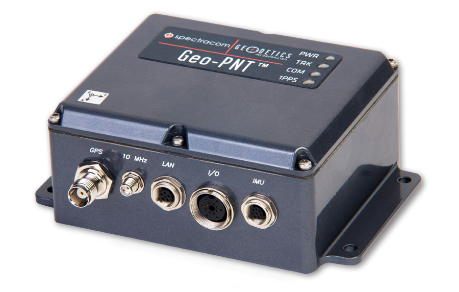
Spectracom’s Geo-PNT integrates precision references for position, attitude, and timing. Photo: Spectracom
A new combination master clock and GPS-aided inertial navigation system is now available from Spectracom to reduce redundant subsystems in mobile applications. The Geo-PNT integrates precision references for position, attitude, and timing all in one box. Applications include radar, optoelectronic sensing, electronic warfare, satcom on the move, and mobile test platforms.
Geo-PNT benefits any mobile intelligence, surveillance, and reconnaissance (ISR) platform because signal/electronic intelligence applications require precision positioning, navigation, and timing references. Electro-optic sensors and other imaging technologies, antenna steering, and encrypted communications always need a combination of precision motion compensation, geolocation, time stamping, and frequency reference.
The high degree of integration within the Geo-PNT supports the goals of low size, weight and power (SWaP) and cost optimization while achieving a high level of performance for ISR platforms and mobile communications systems. A single subsystem for all PNT functions in a volume of about 40 cubic inches is about three times less than the traditional approach of deploying dedicated devices.
The Geo-PNT is a highly configurable platform to provide the capabilities needed for the mission:
Single-box solution combining precision local oscillator, inertial motion unit (IMU), and GPS receiver.
Configurable output interfaces for timing and navigation.
Standalone or RTK/differential GPS, commercial (non-ITAR) or SAASM GPS receiver.
Choose from a variety of IMUs to meet performance specifications.
NTP server, precision 1PPS, 10 MHz with low phase noise.
Rugged and tested to MIL-STD-810G.
Low SWaP (< 0.7 liters, <0.8 Kg, <10 watts).
“Our time and frequency technology, combined with geodetics positioning and navigation capability in the same module, provides an opportunity for platform designers to lower SWaP requirements while staying within the limits of today’s demanding system specifications,” said Rohit Braggs, Spectracom’s sales and marketing VP.
Geo-PNT is the latest example of Spectracom’s flexible configure-to-COTS approach. The use of commercial technology reduces lead time and offers the lowest cost of ownership for both standard and semi-custom configurations. Hardware and software can be adapted to meet the needs of the application.
The Defense Advanced Research Projects Agency (DARPA) is asking for input on how to launch and recover multiple small unmanned air systems (UAS) from existing large aircraft, such as the C-130. It has issued a Request for Information (RFI) seeking technical, security and business insights on “aircraft carriers in the sky.”
In DARPA’s “blended approach,” a large aircraft would host a small UAS and facilitate its operations. The agency says it would be more cost-effective for intelligence, surveillance, reconnaissance (ISR) and other missions.
Safety is another key aspect of the project. While small UAS can reduce putting an aircraft or pilot at risk, DARPA says it may lack the speed, range and endurance of larger aircraft.
“We want to find ways to make smaller aircraft more effective, and one promising idea is enabling existing large aircraft, with minimal modification, to become ‘aircraft carriers in the sky,’” said Dan Patt, DARPA program manager. “We envision innovative launch and recovery concepts for new UAS designs that would couple with recent advances in small payload design and collaborative technologies.”
The RFI is calling for short responses — no more than eight pages — that must address the following three areas:
System-level technologies and concepts that would enable low-cost reusable small UAS platforms and airborne launch and recovery systems that would require minimal modification of existing large aircraft types. This area includes modeling and simulation as well as feasibility analysis, including substantiating preliminary data if available.
Potentially high-payoff operational concepts and mission applications for distributed airborne capabilities and architectures, as well as relative capability and affordability compared to conventional approaches (e.g., monolithic aircraft and payloads or missile-based approaches). DARPA hopes to leverage significant investments in the area of precision relative navigation, which seeks to enable extremely coordinated flight activities among aircraft, as well as recent and ongoing development of small payloads (100 pounds or less).
Proposed plans for achieving full-system flight demonstrations within four years, to assist in planning for a potential future DARPA program. DARPA is interested not only in what system functionality such plans could reasonably achieve within that timeframe, but also how to best demonstrate this functionality to potential users and transition partners. These notional plans should include rough order-of-magnitude (ROM) cost and schedule information, as well as interim risk reduction and demonstration events to evaluate program progress and validate system feasibility and interim capabilities.
According to a news release by DARPA, technology development beyond the three areas will be considered if it supports the RFI’s goals.
Proposals are due by 4 p.m. ET on Nov. 26, 2014, to [email protected].
1Spatial plc, which specializes in spatial big data management, has launched The Little Book of Smart Cities, designed to provide insight into smart cities and how authoritative geospatial data is a foundation for success.
The Little Book of Smart Cities features case studies and industry research, and explains how spatial data are fundamental to the concept of smart cities. The book details how the use of authoritative geospatial data is at the heart of a smart city. It can help city councils manage street lighting or trash-collection timetables, as well as providing the underlying information on which to build large infrastructure projects.
“The Little Book of Smart Cities provides an insight into how authoritative spatial data benefits cities in a connected world,” commented Alison Masters, CMO, 1Spatial. “At 1Spatial we work with the users and creators of some of the largest big spatial databases to help smart city innovators solve the challenges they face. This book shines a light on spatial data and reveals how it is the very foundations on which a smart city is built.”
1Spatial will also be showcasing 1Spatial Management Suite and Elyx GIS platform at the Smart Cities Expo, together with its consulting services, and highlighting how these can be used to help make cities smarter.
1Spatial already has a wide offering in the arena of smart cities and has provided solutions for a number of locations, including Moorabool Shire Council in Australia and the Municipality of Schaerbeek in Belgium, which feature in The Little Book of Smart Cities. 1Spatial has a portfolio of customers across national, regional and local government, transport, utilities, land management and National Mapping Authorities.
Han Wammes, 1Spatial Business Development Manager will be speaking in the UK Pavilion at 10.30am on Nov. 19 on the subject of “Geospatial Data: The Foundation of Smart Cities” by invitation of UK Trade and Investment. Han will look at how nearly all smart city projects have one common foundation — geospatial data. This can range from the simplest data feed to a complex, multi-partner integrated transport system.
Smart City Expo World Congress is a benchmark in smart cities. The event introduces debate and shares pioneering approaches, highlighted by the speakers. It is a meeting point and networking opportunity for companies, government, entrepreneurs and research centers to show off their solutions, learn, share and inspire to support the development of the cities of the future.
Pick up a copy of The Little Book of Smart Cities at Stand #F.621 and meet the 1Spatial Team. Nov. 18-20 at the Gran Via Venue, Barcelona, Spain. If you are not attending the event but would like to get your free copy of the book, visit the website.