Blog

  • Ready for Black Friday: Study Shows Americans Aware of In-Store Beacons

    A new Placecast poll indicates that nearly 118 million smartphone owners will be relying on their phones for holiday shopping this year. For smartphone owners who plan to do holiday shopping, three out of four will use their phones to find sales, comparison shop, take pictures of possible gifts, and make purchases.

    The survey also showed that American shoppers are very aware of in-store beacons, despite the fact that it is a relatively new technology; more than half (52 percent) of the cell phone/smartphone owners surveyed said they have heard of in-store beacons, and 15 percent have engaged with them.

    “Brands that embrace beacons are highly likely to see a spike in their sales in the coming shopping season and in general,” said Placecast CEO Alistair Goodman.

    Beacon technology is only one indoor location technology being pursued by retailers. Kevin Dennehy’s Wireless LBS Insider column from August, Indoor Location Has Major Growing Pains, but Big Upside, provides an overview.

    Conducted in October among more than 2,000 U.S. adults, this was the fifth survey in Placecast’s Alert Shopper series, one of the longest running research series around how consumers interact with various marketing and purchasing mechanisms. This year’s poll reveals the latest trends in mobile shopping and provides key insights for brands and technology providers on how to connect with the highly connected consumer this holiday season, when stakes are high. The poll was conducted online within the U.S. for Placecast by Harris Poll.

    According to the National Retail Federation (NRF), holiday spending will be up nearly 5 percent this year compared to last year, with the average person expected to spend about $800. The NRF reports that gift givers “plan to splurge” for holidays like Christmas, Kwanzaa, and Hanukah: “Consumers are spending more across the board on family, friends, co-workers, pets and even babysitters…Sales and discounts were listed as the most important factor.”

    “It’s not surprising that consumers are most influenced by sales and discounts; the question is, what is the best way to get these offers to them? Our survey looked at various ways brand can reach customers, and we found that reaching users on mobile while they are near stores, and using in-store technology — like beacons — are some of the best ways of reaching consumers who are looking for offers, or for more information to make a purchase,” said Goodman.

    Beacons are a small, low-cost piece of hardware installed in stores. They emit a signal (called Bluetooth low energy, or BLE) that can be targeted directly to phones. Beacons can bring the analytics and targeting capabilities of the online experience to physical stores — for example, sending a discount for perfume to a 40-year-old woman who has recently done an online search for scents.

    Because beacon technology is relatively new, the high awareness level discovered in this wave of the Alert Shopper series may seem surprising to the industry; the research team involved in data analysis for the Harris Nielsen poll explains the possible cause: “Consumers are clearly voting in favor of beacons due to stores promoting them and the value they deliver in couponing. While awareness seems high at 52 percent, this may be due to people wanting to identify with the coolness of new technologies, and certainly indicates huge promise for it. Minority Report is looking more and more like a reality than a movie,” said Kathryn Koegel, chief of Insights and Communications Steampunkt Collaborative.

    Goodman seconds this “halo effect” of new tech: “There could very well be a huge halo effect here, but nonetheless, one fact remains: we are all now assuming that there is technology in stores that can connect with our phones — whether it’s opening an app or getting a push notification. But the real art lies in delivering timely and useful ads and offers, not overwhelming the consumer, and making sure the promotions are targeted accurately.”

    The Alert Shopper V survey revealed that 15 percent of cell phone/smartphone owners had interacted with beacons. “Though this number is likely higher than the actual number of people who have interacted with in-store beacons, the fact that people are highly aware of them and think they interact with them bodes well for the technology,” said Koegel.

    The importance of in-store marketing was underscored by another data point from the Placecast survey; the top activity for Mobile Millennial females (women 18-34 who own a smartphone and plan on doing any holiday shopping this year) — when asked what they plan to use their smartphone for while holiday shopping this season — is searching for a coupon for a store they are already in, with over half (52 percent) looking to save money by checking their phones. The same percentage said they would use their smartphone to take a picture of a potential gift to text a friend or family member for their opinion (52 percent).

    The Alert Shopper Survey #5 revealed these key takeaways for brands and marketers this holiday season:

    • Phones are an integral part of the shopping process: among those who plan on doing any holiday shopping, 3 out of 4 smartphone owners plan to use their phones for some part of their gift-finding and buying experience.
    • Among all smartphone owners, searching for an item in a search engine to find a local retailer topped the list of mobile actions for holiday shopping this season, with 2 out of 5 (39 percent) saying they plan to use their smartphone for this; sending a picture of a potential gift to a friend or family member at a close second (38 percent), followed by searching for a coupon for the store they’re in (33 percent).
    • Mobile Millennials are the most active mobile shoppers this holiday season: Young men ages 18-34 (91 percent) and women ages 18-34 (85 percent) who own smartphones reported the highest percentages when asked if they plan to use their phones while shopping this holiday season; these Millennials make up about 25 percent of the United States population, outpacing Baby Boomers and Gen X (ages 28-38). Though they have not reached their peak spending potential, Millennials nonetheless control 21 percent of consumer discretionary purchases, which is estimated at over a trillion dollars in direct buying power and a huge influence on purchases by older generations (i.e., parents and grandparents).
    • Moms and dads with children under 18 in their household will be very active on mobile: 86 percent of dads plan to use their smartphones for holiday shopping this year. When asked what they will use their phones for the most popular answer among dads was “use my phone to look for an item in a search engine to find a local retailer.” Over half (54 percent) gave this answer. Three out of four (75 percent) mothers plan on using their smartphones for holiday shopping this year. While men are searching for retail locations, mobile moms selected “take pictures of potential gifts to text and get opinions from friends/family” as the top mobile activity, with nearly half (48 percent) saying they will do this.

  • New Global Military Market Report Published

    Research and Markets has added the report “The Global Military GPS/GNSS Market 2013-2023” to its offerings.

    Satellite navigation has been at the forefront of technological developments. GPS, the most efficient and widely used satellite navigation system, is in the process of being upgraded by the technologically advanced satellites called GPS III. Once manufactured only by the U.S., satellite navigation systems are now being developed by other countries as well.

    The IRNSS in India, Compass (BeiDou) in China, and Galileo in Europe are examples of systems that are either operational or are expected to be so in the next few years. These navigation systems are expected to create new opportunities in the GPS/GNSS market. The new navigation systems will require receivers’ and applications compatible with the new systems.

    Although, Galileo is interoperable with GPS, it still would require new receivers and applications to complement the new system. China’s BeiDou is already partially in operation, and is expected to become fully operational by 2020. Countries such as Sri Lanka and Thailand are buying the system from China. The expansion in the use of the Chinese navigation system during the period 2015-2020 will involve military spending on COMPASS receivers both in the domestic market as well as the international market.

    Topics covered include:

    • Introduction
    • Executive Summary
    • Global Military GPS/GNSS Market Size and Drivers
    • Industry Trends, Recent Developments and Challenges
    • SWOT Analysis of the Military GPS/GNSS Market
    • Country Analysis – Military GPS/GNSS Market
    • Major GPS/GNSS Devices Programs
    • Competitive Landscape and Strategic Insights
    • Appendix

    Companies mentioned include:

    • BAE Systems
    • ITT Exelis
    • Lockheed Martin
    • Northrop Grumman
    • Raytheon
    • Rockwell Collins
    • Thales
  • Report: Moto 360 Leads First Wave of Android Wearables

    Report: Moto 360 Leads First Wave of Android Wearables

    Android_Wear_watch-O
    Photo: Motorola Mobility

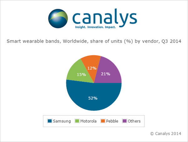
    Nearly 5 million smart and basic wearable bands shipped in Q3 2014, with total unit shipments increasing 37% quarter on quarter as Android Wear made its mark for the first time, according to a report by independent analyst company Canalys.

    Motorola Mobility’s Moto 360 was by far the most successful of the initial Android Wear devices, accounting for more than 15% of the smart band market according to Canalys estimates. Despite being supply-constrained, its appealing design helped it to easily out-ship other Android Wear products.

    LG has responded to early interest in the Moto 360 by quickly adopting a circular display with the G Watch R.

    Meanwhile, Samsung remained the overall smart band market leader, and the company has already begun to experiment with larger display sizes and cellular connectivity with the Gear S, its sixth smart band.


    Look for GPS World’s cover story on wearables, “The Fashion Demands of Always On“.


    Though the platform is still young, Android Wear will be fundamental to the development of the market, as it is poised to be one of the two dominant wearable operating systems outside of China, alongside Apple’s Watch OS. But Google will need to redesign the Android Wear user interface before the platform can achieve its true potential.

    Canalys-Moto-360-leads-the-first-wave-of-Android-Wear-devices-W

    ‘The announcement of the Apple Watch late in the quarter has likely had an effect on sales of existing devices, as some consumers will choose to wait for Apple’s wearable,’ said Canalys Analyst Daniel Matte. ‘The smart band market was flat between Q2 and Q3, but with an installed base of over 1.8 billion Android smart phones, there is a huge potential market of Android users not considering an Apple Watch.”

    Fitbit and Jawbone held onto their first and second place positions, respectively, in the basic band market for the quarter, and both have just announced new products. Garmin passed Nike to take third place in shipments, while Xiaomi and Huawei also overtook the one-time market leader and rounded out the top five. “Low-end basic bands providing simple activity tracking functionality are becoming increasingly commoditized, and will flood the market heading into the holidays, especially in China,” said Canalys Analyst Jingwen Wang. ‘To combat this, Fitbit, Jawbone and others have attempted to make basic bands smarter, adding various smart watch features and increasing the sophistication and integration of sensors.’

    Google Fit, Microsoft Health and the Samsung Digital Health Platform have all recently been announced in response to Apple’s HealthKit. While the new Microsoft Band does not have strong hardware appeal, Microsoft’s cross-platform cloud services approach is a wise strategy, and the company is importantly staking its relevance early in a new market. There is tremendous opportunity for brand new services on wearable platforms, and not just in the area of health and fitness. Expect developers to eagerly embrace Apple’s WatchKit SDK, expected to be released in early 2015.

    Wearable band shipment data is taken from Canalys’ Wearable Technology Analysis service, which provides quarterly market tracking, including country-level estimates. Canalys defines basic wearable bands as devices serving a specific set of purposes that act as accessories to smart devices, are designed to be worn on the body and not carried, and that cannot run third-party computing applications. Smart wearable bands are multi-purpose devices that serve as accessories to smart devices, are designed to be worn on the body and not carried, and are capable of running third-party computing applications. Bands are wearables designed to be wrapped around the body and do not include activity trackers in the form of clips.

  • NGS Seeks Geodesist

    The National Geodetic Survey is seeking applicants for a geodesist (real-time kinematic network) with the Spatial Reference System Division. Applications are being accepted through December 4.

    The individual selected for this position will:

    • Serve as subject matter expert and liaison to the Real-Time Kinematic Network (RTN) community.
    • Assist in defining policy and guidance related to RTN for geodetic products and services.
    • Serve as customer service representative responding to inquiries from various users regarding the geodetic products and services related to OPUS and RTN’s.
    • Perform software maintenance, development, testing, debugging, and refining NGS software to improve NGS Online Positioning User Service (OPUS) Products and Services for use in validating RTN base stations.

    Application links are:

    Current U.S. government employees

    All U.S. citizens

  • U.S. Alerts EU Against Giving Galileo Preferential Treatment

    Space News is reporting that the U.S. government has alerted the European Union that any preferential treatment the EU gives to its Galileo positioning, navigation and timing network will likely violate World Trade Organization (WTO) agreements signed by the United States and the 28-nation EU.

    According to a report by Peter B. de Selding, U.S. government officials voiced concerns that the EU is weighing equipment mandates for aviation, car-accident reporting and emergency-call regulations that could unfairly tip the scales in favor of Galileo to the detriment of U.S. GPS-enabled hardware.

    In a presentation to the 9th Meeting of the International Committee on GNSS, held Nov. 10-14 in Prague, a senior GPS official said the United States and the EU have signed a wide body of satellite navigation agreements designed to promote open market access and interoperability.

    European Commission officials have said in recent months that they are still weighing how to stimulate Galileo use.

  • Trimble Introduces New Solution for Interior Wall Layout

    Trimble is now offering Spectra Precision QML800 QuickMark Layout, a new solution that automates the layout of interior points and walls. The QML800 allows drywall and interior contractors to quickly and efficiently lay out points for interior building construction.

    With QML800, two lasers create a bright visible “X” directly on the point for easy, quick marking. The lasers are controlled by the mobile application running on with an Android tablet that stores the point files. When a point is selected, the lasers position the “X” at that point in less than 5 seconds. For brightest conditions, a laser pointer accessory easily aids in finding the laser beams.

    “The interior drywall contractor faces many challenges and complexities regarding scheduling, trade conflicts and layout accuracy. They need better tools and technologies that provide a quicker method of layout than tape measures,” said Mike Bank, general manager of Trimble’s Precision Tools business. “The QML800 is an affordable solution that addresses these challenges and automates the interior wall layout process.”

    On the jobsite, there are many potential causes for errors. The QML800 laser accuracy is typically 1/8 inch (3 mm), easily meeting most jobsite requirements. Misinterpreting drawings and tape measure reading errors are eliminated. Because each point is laid out independently, compounding errors from one bad point to another is eliminated. Complicated shapes, arcs and curves are now easy to layout. Multiple methods of simple point file creation are possible including CAD freeware, Excel spreadsheets and manual entry. Points can also be entered directly on the tablet at the jobsite as needed.

    The QML800 is designed to be used by layout crews without a surveying background. The tablet is intuitive with the normal swipe, scroll and enlarge functions. Compared to the traditional drawing and tape measure process, the QML800 saves labor, reduces errors and increases productivity. The solution is fast, accurate and easy to use.

    The Spectra Precision QML800 is expected to be available late November through the Spectra Precision global dealer network.

  • Interactive Senate Maps Seek to Explain International Issues

    The U.S. Senate Foreign Relations Committee is offering a new webpage with a varietof interactive international maps using GIS technology.

    From showcasing maps reflecting worldwide GDP growth rates and unemployment rates, to highlighting Freedom House’s annual countrybycountry report on political rights and civil liberties, thnewly launched feature on the Senate Foreign Relations Committee website helps visually tell important global stories and trends, the committee said.

    As chairman of the Senate Foreign Relations Committee, I want to find different ways to engage the public in keforeign policy issues, and the use oGIS technology is one way to do that,” said Chairman MenendezThese dynamic maps help bring a new dimension to understanding international issues in a quick and visual way. From relaunching the committee’s website, to establishing a committee twitterfeed, and now utilizing this mapping technology, the Senate Foreign RelationCommittee is reaching out to broader anmore diverse audiences to increase engagement on international issues.”

    The chairman’s maps were created using Esri’s Senate Analytical Mapping System, a product providefreeofcharge to congressional offices to conduct research and showcase trends using geospatial data visualizations.

    A screengrab of the new map feature on the Senate Foreign Relations Committee website.
    A screengrab of the new map feature on the Senate Foreign Relations Committee website.

  • Out in Front: My Heart in My Sleeve

    The next time I see Paris, I will be swinging down the boulevard in a brand new set of threads. An elegant, location-enabled set of threads that will take me by the sleeve and lead me through the City of Light.

    This wearable experiment goes by the name — of course it does — Navigate, a new line of city-specific, location-enhanced apparel. Either plug or Bluetooth the jacket (the press materials are not clear on this point) into your smartphone, download the appropriate city guide with walking tour, and start your adventure. Stash the phone in the pocket of the houndstooth jacket with red felt collar flips, no further need to look at it. Vibrations along left or right arm tell you when to turn; their frequency, intensity, and placement vary to indicate soft turn, merge, or hard turn.

    Oh, I love the colorful clothes she wears, and the way the sunlight plays upon her hair . . . I’m pickin’ up good vibrations, oom bop bop, she’s giving me excitations, oom bop bop. 

    Good, good, good, good vibrations. 

    “How we can ease the stress of navigating an unfamiliar path without interfering with the experience of discovering a new place?” asks Billie Whitehouse, design director of Wearable Experiments. “No longer do you need to hunch over a map or smartphone. Now you can experience fill-the-blank-here as a traveler rather than a tourist.” 

    Not interfering with the experience of discovering a new place: that caught my attention. In my misspent youth, I traversed the upper Amazon, the Andean highlands, and the Galapagos Islands unencumbered by a camera. To my lasting regret. I thought the device lifted to my eyes would interfere with my discovery and experience. Now I see my error. Instead of subtracting a layer of technology from my travel trunk, I should have added one. That GPS did not exist at that time, except as a gleam in young Col. Parkinson’s eye, perhaps absolves the fault in this case.

    “The skin is a vastly underutilized form of communication,” says Wear:Ex technical director Ben Moir. “Haptic vibrations are built into a full physical language, allowing the technology to communicate critical information. Technology doesn’t need to be invasive or obtrusive. It should be designed with the human at the center.”

    From signals in space to the surface of my skin. It doesn’t get much more human-centric than that. 

    Je me baladais sur l’avenue,

    Le coeur ouvert à l’inconnu.


    Also read GPS World’s December cover story on GNSS chip architecture for wearables, “The Fashion Demands of Always-On.”


  • Sensors in Motion Launches MEMS-Based Inertial Nav System

    Sensors in Motion Launches MEMS-Based Inertial Nav System

    SIM-MEMs-based-Inertial-Navigation-System-W
    Photo: SIM

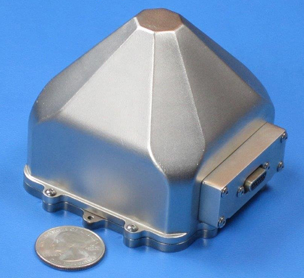
    Sensors in Motion (SIM) has introduced  a MEMS (micro-electro-mechanical) navigation-grade inertial system (INS) that it says could transform the $8 billion/year inertial market with new products by offering price and performance specifications better than those currently available.

    The first INS devices have been delivered to the Army CERDEC Night Vision Electronic Sensors Directorate (NVESD).

    SIM, a spinout from NASA’s Jet Propulsion Laboratory and California Institute of Technology, is developing a family of high-accuracy MEMS gyroscopes, accelerometers and inertial measurement unit ( IMU) solutions. It says it has perfected unique MEMS structures using volume silicon wafer processing techniques to produce gyroscopes having ARW (angle random walk) less than 0.0035 degree/root-hour and bias instability less than 0.01 degree/hour with extraordinary vibration and temperature immunity, a performance comparable to ring laser (RLG) and fiber optic (FOG) gyros that are 20 times larger and 100 times more expensive.

    These features are mandatory for numerous applications where location is not available from GPS or vehicle position accuracy is required including autonomous vehicles, drones, mining asset tracking, dead reckoning, agricultural seed placement, oil and gas directional drilling, self-driving autos, firefighter navigation, optical image stabilization, industrial equipment azimuth, aerospace and defense products and most GPS-denied environments, in addition to new applications.

    Current devices would have a vehicle position off as much as 1 foot per second at 45 miles per hour.

    “We see this technology opening an additional $2B sensor market needing size, weight, power, cost and performance that does not exist today. “ said David Smukowski, CEO of SIM.

    With adequate resources the company says further performance gains are possible, even while shrinking the devices smaller for better economics.

  • BeiDou, Dead Reckoning Added to SiRFstarV 5ea Auto Platform

    CSR plc has released significant upgrades for the SiRFstarV 5ea automotive-grade quad-GNSS location platform. Support has been added for concurrent use of GPS and BeiDou (BDS) satellite constellations, along with major updates to the SiRFDRive software dead-reckoning algorithms. Together, these upgrades ensure that SiRFstarV 5ea offers improved automotive positioning performance meeting the requirements of OEMs across the globe.

    CSR is being acquired by Qualcomm, with the transaction expected to close by the end of the summer of 2015.

    By adding support for China’s BDS constellation to SiRFstarV 5ea’s existing GPS and GLONASS capabilities, the new software offers automotive OEMs the flexibility to perform concurrent GPS and GLONASS or GPS and BDS operations. The new BDS capability provides OEMs the opportunity to market their products to regions where BDS support is mandated and also exploit the benefits of the BDS satellite constellation which is now fully operational over China and surrounding countries. The SiRFstarV 5ea platform, which is optimized and certified for the strict requirements and life cycles of the automotive industry, is also Galileo-ready through future software upgrades.

    “Automotive OEMs from around the globe all have something to gain from the new additions to our cutting-edge SiRFstarV 5ea automotive location platform,” Anthony Murray, senior vice president, Business Group, at CSR, said. “Tier Ones and OEMs are looking to develop global platforms that can be easily configured to meet regional requirements and preferences, while Asian car manufacturers in particular have been calling for simultaneous GPS and BDS support to meet regional market needs for BDS support.”

    SiRFDRive for SiRFstarV 5ea now also includes CSR’s latest dead reckoning algorithms that work alongside concurrent GPS and GLONASS operations. The combination of increased satellite visibility and the latest dead-reckoning algorithms improves the overall performance in challenging environments such as Chicago and Tokyo by a factor of two.

    “Many Tier Ones are looking for more complete dead reckoning solutions to simplify the design process and accelerate time to market. SiRFDRive is a state-of-the-art plug-and-play solution that covers a range of end products spanning from low to high end telematics and navigation systems,” continued Murray.

    SiRFstarV 5ea is designed for automotive market AEC-Q100 qualification requirements as a standalone location engine platform. The platform provides automotive Tier One suppliers and OEMs around the world with continuous, highly accurate positioning capabilities for the next generation of in-dash navigation and telematics applications in cars, trucks and other moveable assets requiring automotive-qualified devices.

    Updated SiRFstarV 5ea evaluation kits are available now, and the SiRFstarV 5ea platform is ready for immediate integration into next generation infotainment and telematics products.

    CSR provides the following video describing SiRFDrive.

  • Handheld CEO Predicts Mobile Computing Trends for 2015

    Handheld CEO Predicts Mobile Computing Trends for 2015

    Jerker Hellström, founder and CEO of Handheld Group.
    Jerker Hellström, founder and CEO of Handheld Group.

    Jerker Hellström, founder and CEO of Handheld Group, has identified three key trends in mobile computing in 2015. Handheld is a maker of rugged computers for professionals.

    His predictions:

    1.    Larger displays even for rugged mobile computers. 

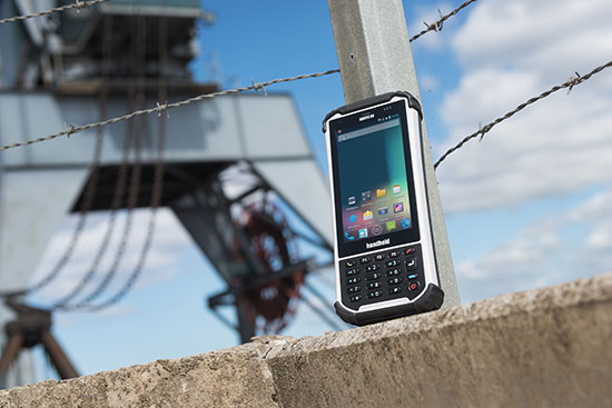
    “Rugged laptops, tablets, PDAs and smartphones continue to be the fastest growing market mobile computer segment, and just like the screen size of smartphones for the mass market has increased, so will the displays of rugged computers. Screen size is the “$64,000 question” in the rugged computer segment — it is a  major consideration for all users, but it is also linked to the application and how data and information are presented, both in terms of how it is captured and how it is communicated to the end user. I foresee a stronger demand for maximum screen real-estate in the smallest, lightest possible form factor. (One real-life example would be the recently launched Nautiz X8 by Handheld with a huge 4.7-inch display for an IP67-rated rugged device).”

    2.    Higher IP ratings. 

    “Mobile computers across all market segments are increasingly being manufactured, and marketed, as more durable, more rugged and with higher IP ratings (ingress protection against water and dust). This a function of computers, tablets and smartphones being with us all the time, everywhere. The consumers demand durable devices that can be knocked around a bit! But it has also become a marketing gimmick. Some devices are now advertized as having the previously unattainable IP68 rating. But do the customers actually understand it? It actually means nothing unless the manufacturer informs us of the submerged time and depth. I expect a continued upwards ‘IP rating creep’ but also an invigorating discussion about the definition and value of IP ratings and the tests carried out on mobile computers.”

    3.    Increasing interest for Android. 

    “Microsoft Windows Mobile or Windows Embedded has for a long time been the operative system of choice for rugged mobile devices, albeit with increasingly stronger competition from Android. 2015 will be the year when he industry truly embraces Android. The rapid growing of Android consumer phones has standardized the Android user behavior and generated a spillover effect to the industrial sector. There is an increase of industrial software being developed for Android, boosted by the first generation industrial Android devices. Also, Android can take advantage of powerful multicore CPUs in a way Windows Embedded Handheld has not been able to.

    handheld-nautiz-x8-ultra-rugged-android-W
    The Nautix X8 rugged Android handheld.

    Jerker Hellström is the founder and CEO of Handheld, a manufacturer of rugged mobile computers, PDAs and smartphones. He is a pioneer and industry veteran in the mobile rugged computer industry. In both entrepreneurial and managerial positions, he has more than 25 years of experience from developing, designing, manufacturing and marketing rugged computers globally. Jerker´s educational background is in engineering and computer science.

  • LizardTech Updates Educational Licensing Program

    LizardTech, a provider of software solutions for managing and distributing digital content, is offering its complete product line to the students and faculty of higher education institutions for use in a research and teaching environment. Included in the program are the latest versions of GeoExpress, Express Server, LiDAR Compressor, and GeoGofer.

    To promote research and learning, LizardTech has included GeoExpress 9 in the educational licensing program. GeoExpress is a tool for compressing, manipulating, and viewing geospatial imagery. LizardTech has also included Express Server 9, an image server that students and faculty can use to share geospatial imagery with other researchers and students around the world. Because LizardTech software was designed with integration in mind, students can streamline their workflow by exporting imagery from GeoExpress directly to Express Server, LizardTech said.

    The educational licensing program also includes LiDAR Compressor, which turns giant point-cloud datasets into efficient MrSID files, and GeoGofer, the newest addition to the LizardTech product line. GeoGofer is LizardTech’s new organizational tool which includes search and filter features to simplify the process of finding and accessing imagery.

    Universities, schools, and research programs can get access to one of the two education bundles offered by the educational licensing program. The first educational license bundle includes one Express Server 9 license, one LiDAR compressor license, five GeoGofer licenses, and three GeoExpress 9 floating licenses with a three terabyte network data cartridge. With this bundle, the first year of support and maintenance is required and costs $1,999. From the second year onward, the annual support and maintenance fee will be $1,999 for each year.

    The second LizardTech educational license bundle includes one Express Server 9 license, two LiDAR Compressor licenses, 10 GeoGofer licenses, and 10 GeoExpress 9 floating licenses with one 10 terabyte network cartridge. The first year of support and maintenance is required and costs $2,999. From the second year onward, the annual support and maintenance fee will be $2,999 for each year.

    The software is provided at no cost to educational institutions as a right-to-use license. The license is valid for one year from the date that support was purchased and will be renewed on an annual basis upon receipt of payment for technical support and maintenance.

    “LizardTech realizes the importance of supporting academic institutions in their training of the next generation of geospatial professionals,” said Jon Skiffington, LizardTech’s director of product management. “By providing our entire geospatial line of products LizardTech is giving students and faculty the latest tools to compress and manipulate massive geospatial imagery and distribute it via the Internet to any device.”

    To learn more visit the educational licensing program page.