Ricoh Americas Corporation has made major improvements to its water-, dust- and shock-resistant G800 camera. The G800SE model includes GPS and a barcode-reading capability that helps streamline workflows across a wide range of industries.
The new Wi-Fi- and Bluetooth-enabled Ricoh G800SE allows for dynamic information capture in industries such as automotive, logistics, government, healthcare, emergency services and more. For example, a car dealership can scan the barcode on a new car, photograph the vehicle, and have the photograph and vehicle information flow directly to the dealership website for customers to see. This new workflow saves hours of painstaking information retrieval and organization, Ricoh said. With a standard camera, clerks would need to manually match images to each car, introducing the possibility of error at every step.
“By embedding critical data into images, the Ricoh G800SE epitomizes information mobility, the ability for employees to access just the information they need in the form they need it to make important decisions,” said Matt Sakauchi, vice president, Technology Marketing, Ricoh Americas Corporation. “This is just one way we’re making customers’ business information work for them in this new world of work.”
The Ricoh G800SE includes a host of upgrades over the previous generation of ruggedized Ricoh wireless-enabled camera, the Ricoh G700SE. For example, a higher-resolution image sensor provides a new ability to capture images under low-light conditions. The Ricoh G800SE also takes advantage of higher wireless transmission speeds and the more secure “enterprise” Wi-Fi increasingly seen in healthcare facilities and government agencies. It leverages the Protected Extensible Authentication Protocol (PEAP), an emerging standard in enterprise wireless security.
A flexible password lock feature enables organizations to create separate passwords for administrators and users with each one unlocking different sets of permissions. A smartphone connection enables users to remotely operate the camera via their mobile devices. Using a smartphone or tablet, they can preview, zoom, shoot and capture image data, including GPS position. The capability is also intended for surveillance applications.
Organizations can manage fleets of Ricoh G800SE cameras via remote management software with the ability to upgrade firmware, adjust camera settings and update memo functions. An alternative for camera configuration is distributing SD cards with prescribed settings.
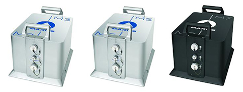
iXBlue unveiled its Marins M series inertial navigation system (INS) at EURONAVAL 2014, held October 27-31 in Paris, France. The series includes the Marins M3, M5 and M7 systems and is designed to address the needs of the world’s most advanced navies for surface-vessel and submarine operations close to shore and in open-sea environments.
Accurate and reliable navigation, including missile alignment, is critical to the success of submarine and surface-vessel missions. The Marins M series raises the bar in performance and scalability by addressing the needs of surface ship navigation under a GPS-denied environment. For submarines, Marins M7 enables three times longer autonomous stealth navigation compared with any available system by offering drifts of less than 1 Nm/72 h.
The Marins M series represents the state of the art in strap-down, fiber-optic gyroscope (FOG) technology, and is combat-ready against GNSS denial, iXBlue said. The military-specification units output position, heading, roll, pitch, depth and velocities, and are perfectly silent. The systems are compatible with a wide range of aiding sensors and can be up and running within minutes.
The extended iXBlue product range, including Quadrans, Octans, Phins and Marins M series systems, now represents even higher scalability of solutions, from attack craft to aircraft carriers and submarines.
More than 30 navies worldwide have selected the iXBlue product range, including previous generations of Marins systems. For example, the UK Royal Navy has adopted advanced iXBlue solutions for its Astute Class submarines.
The National Geospatial-Intelligence Agency made available October 23 a public-facing website to assist U.S. and international relief efforts to combat the spread of the Ebola virus disease, providing unprecedented online access to its unclassified geospatial intelligence in support of lead federal agencies and partners.
NGA’s efforts add important value to the support offered by other organizations, including the All Partners Access Network, which provides community spaces and collaborative tools to the Department of Defense and mission partners to leverage information to effectively plan, train and respond to mission objectives.
“The dynamic site provided by NGA allows the agency to automatically federate its geospatial content, which then is used by organizations such as APAN for mission-related efforts,” said agency Director Robert Cardillo.
NGA’s role in the Ebola crisis has been in step with many other global events that have required the agency’s disaster support, including Hurricane Katrina in 2005, the Haiti earthquake in 2010, Hurricane Sandy in 2012 and Typhoon Haiyan in 2013. The
agency’s focus on unclassified support to the crisis allows its content to be available with no caveats or limits in distribution.
The large number of non-governmental organizations, or NGOs, involved in the relief effort requires NGA take a different approach to disseminating unclassified information so the people who need NGA’s information on the crisis, have it.
The dynamic site uses Esri’s ArcGIS Platform hosted in the cloud by Amazon Web Services, both publically available services. The site features various base maps that provide foundational context for users, who will then have the ability to visually overlay public NGA data, as well as ingest open-source data. NGA’s data can provide logistical information relevant to the situation on the ground affected by the Ebola crisis.
NGA’s first exposure of data includes geospatial layers relevant to the Ebola outbreak in Guinea, including cultural places and structures, and communication, electric power and ground transportation infrastructure. For example, Ebola cases by province and
locations of emergency treatment units will be visually accessible for users to ascertain the distance from a certain airfield to the closest emergency treatment unit.
Under Foundation GEOINT Content Management (FGCM) contracts, Harris will create high-quality data and products of the Pacific, North America, South America, and Africa regions of the world for use by the U.S. intelligence community and military. FGCM will contribute to and maintain a comprehensive, geospatially accurate map of the world that can be accessed quickly as intelligence, operational, and crisis needs arise.
Harris will use its One Feature One Time database, which automatically eliminates data redundancy and stores the most current representation of each geospatial feature. This capability ensures data currency and significantly reduces the time required for processing and delivery of products compared with traditional methods.
“Our unique solution provides improved accuracy, reduced production costs and significantly faster turn-around of geospatial products and content,” said Bill Gattle, vice president and general manager, National Programs, Harris Government Communications Systems. “This major win continues our legacy of providing high quality, responsive geospatial products to the intelligence and military communities.”
zLense, a specialist provider of virtual production platforms to the film, production, broadcast and gaming industries, is offering a depth-mapping camera that captures 3D data and scenery in real-time and adds a 3D layer to the footage. The camera is optimized for broadcasters and film productions.
The technology processes space information, making new and real three-dimensional compositing methods possible, enabling production teams to create 3D effects and use state-of-the-art CGI in live TV or pre-recorded transmissions, with no special studio set up.
With the zLense Virtual Production platform, directors can produce simulated and augmented reality worlds, generating and combining dynamic virtual reality (VR) and augmented (AR) effects in live studio or outside broadcast transmissions. The depth-sensing technology allows for a full 360-degree freedom of camera movement and gives presenters and anchormen greater liberty of performance. Directors can combine dolly, jib arm and handheld shots as presenters move within, interact with and control the virtual environment and, in the near future, using only natural gestures and motions.
“We’re poised to shake up the Virtual Studio world by putting affordable high-quality real-time CGI into the hands of broadcasters,” said Bruno Gyorgy, President of zLense. “This unique world-leading technology changes the face of TV broadcasting as we know it, giving producers and program directors access to CGI tools and techniques that transform the audience viewing experience.”
Doing away with the need for expensive match-moving work, the zLense platform dramatically speeds up the 3D compositing process, making it possible for directors to mix CGI and live action shots in real-time pre-visualization and take the production values of their studio and OB live transmissions to a new level. The solution is quick to install, requires just a single operator, and is operable in almost any studio lighting.
“With minimal expense and no special studio modifications, local and regional TV channels can use this technology to enhance their news and weather graphics programs — unleashing live augmented reality, interactive simulations and visualizations that make the delivery of infographics exciting, enticing and totally immersive for viewers,” he continued.
The zLense Virtual Production platform combines depth-sensing technology and image-processing in a standalone camera rig that captures the 3D scene and camera movement. The matte box sensor unit, which can be mounted on almost any camera rig, removes the need for external tracking devices or markers, while the platform’s built-in rendering engine cuts the cost and complexity of using visual effects in live and pre-recorded TV productions. The zLense Virtual Production platform can be used alongside other, pre-existing, rendering engines, VR systems and tracking technologies.
The VFX real-time capabilities enabled by the platform include:
Volumetric effects
Additional motion and depth blur
Shadows and reflections to create convincing state-of-the-art visual appearances
Dynamic relighting
Realistic 3D distortions
Creation of a fully interactive virtual environment with interactive physical particle simulation
Wide shot and in-depth compositions with full body figures
Russian companies looking to develop GLONASS products and services can soon tap into an 8-billion-ruble fund. Russian state development bank Vnesheconombank (VEB) plans to offer financial support for projects using GLONASS, pending government approval, according to the Russian news agency Ria Novosti.
VEB’s sister fund, VEB Innovations, will set up the GLONASS Fund in the fourth quarter of this year, with funds made available by next February-March. The fund will include 5 billion rubles ($122 million) from VEB and 3 billion rubles ($73.1 million) from private investors.
The project is designed to expand GLONASS market share, both to acquire advanced technology and attract new customers. It aims to support small companies with new, innovative ideas. Its goals will include the creation of an investment model that will ensure that the most promising and viable projects reach market, from conception to production.
Assistance will be sought from specific European, North American and Asian technology companies, including Norway’s Q-free, Switzerland’s Saphyrion, Slovakia’s Sygic, the Netherlands’ AND, France’s Benomad, and the Germany companies Peiker, Init and IVU. Each of these companies is involved in navigation, with hardware, software, GIS and mapping software, telematics or dispatching. The GLONASS Fund concept says that by using these technologies for the development of new domestic products and services, GLONASS can achieve technical superiority in all the major segments of the global navigation and information market.
The fund’s support will include contacts with Russian trade representatives abroad to promote the Russian products in markets such as India, Latin America and the Middle East.
Mauro Colombi, vice president of operations for Stonex, discusses the new S10 GNSS Receiver while at InterGeo 2014, held October 7-9 in Berlin. The S10 features a new generation of smart and open GPS, where a user can install custom applications directly on the receiver.
The Air Force is set to launch the eighth GPS IIF satellite from Cape Canaveral Air Force Station in Florida on October 29. The 18-minute launch window opens at 1:21 p.m. EDT.
An Atlas V 401 will launch the GPS IIF-8 mission for the U.S. Air Force.
As described by the Air Force, GPS IIF-8 is one of the next-generation GPS satellites, incorporating various improvements to provide greater accuracy, increased signals, and enhanced performance for users.
GPS IIF-8 will be United Launch Alliance’s fourth GPS launch of 2014 and the 12th of the year. The mission will mark ULA’s 89th mission launched since the company was founded in 2006.
To keep up to speed with updates to the launch countdown, dial the ULA launch hotline at 1-877-852-4321 or join the conversation at www.facebook.com/ulalaunch and twitter.com/ulalaunch; look for the #GPSIIF8 hashtag.
The Air Force Second Space Operations Squadron (2 SOPS) indicates that IIF-8, SVN-69/PRN-03, will replace SVN-51 in the E plane slot 1. SVN-51 will be re-phased from E1 to an auxiliary node at E7 somewhere around SVN-54 currently on station at E4. SVN-38/PRN-08 will be taken out of the operational constellation prior to SVN-69 payload initialization and sent to Launch, Anomaly Resolution and Disposal Operations (LADO). PRN-08 will be assigned initially to SVN-49 and set to test.
SVN-38 was launched on November 5, 1997, successfully serving nearly 17 years, 9.5 years beyond its designed service life, due to the diligent efforts of the men and women of the U.S. Air Force. SVN-51 will remain in an auxiliary node once it completes its re-phase journey. The SVN-51 re-phase will take about six months after the initial burn occurs.
Because of nonstop government regulation, which can help and hinder the trucking industry, the mobile resource management market will continue to be one of the strongest location segments. In other news this month, while it doesn’t get much bigger a deal in the location industry than a $2.5 billion purchase, as in the case of Qualcomm buying CSR, one smaller deal that should not be overlooked is ST Telecom’s acquisition of Shopkick, a growing indoor location provider.
SAN DIEGO — The global trucking market for fleet management products has always been strong — and one of the first location segments to have prospered over the last 15 years. This market growth will continue because of new technology and government requirements, say attendees at the American Trucking Association annual management conference here.
An American Transport Research Institute report offered at ATA, “Critical Issues in the Trucking Industry – 2014,” outlines 10 issues, mainly driven by government regulation, that concern fleet owners.
One of the big issues is hours of service (HOS). Rules adopted by the feds require 11 hours of driving — and a 34-hour break before restart. This includes a 30-minute break before driving again after eight hours. ATRI believes these rules cost carriers $1.6 billion to $3.9 billion annually in driver pay impacts.
An electronic device (ELD) mandate requires all drivers to keep records of duty status via a logging device. A mandate could come in 2016 that outlines hardware specs.
Another big issue is truck parking — and could be an opportunity for mapping and location companies. Because HOS regulations require drivers to take many breaks, shortage of parking is a big and dangerous concern because drivers are operating beyond allowable rules to find areas to park. ATRI wants closed public rest areas to reopen. They want real-time truck parking information availability and trucking parking reservation systems.
Driver distraction in the form of texting and driving is a growing concern. ATRI wants the feds to ban hand-held cell-phone use/texting for all motorists, encourage harsher penalties and more aggressive enforcement, and to continue to research to understand the size of the distracted-driving problem.
Other issues include driver shortage, health and retention; compliance, safety, Accountability (CSA); and congestion funding.
“My takeaway from [ATA’s] luncheon panel was that the trucking sector is in pretty good shape overall, except for the driver shortage. In regard to mobile resource management (MRM), I would estimate overall growth in in-cab and trailer monitoring at less than 10 percent per year,” said Clem Driscoll, president, CJ Driscoll Associates. “The Truckload sector is heavily penetrated with in-cab solutions. Most large carriers have a system. CSA is motivating some sales to mid-size fleets, but many small fleets are waiting for the ELD regulations. So, the delays with ELD regulations have probably been slowing market growth.”
Such companies as AT&T are trying to address the growing trucking requirements with new and existing products. For example, Saia LTL Freight, a trucking and logistics company, is managing its fleet of trucks with several AT&T products. Saia drivers are using handheld computers to connect with dispatch managers and monitor fuel consumption, safety, and location using AT&T’s wireless network.
“[SAIA] is a trucking company that is using all our capabilities. We partnered with them from an early stage, starting with the [Electronic Device Mandate] requirements,” said John Moscatelli, AT&T advance resource management solutions director. “Then we helped them with rugged handhelds and voice where necessary.”
Overall, Moscatelli sees a few fleet trends emerging. “There have been a lot of mergers and acquisitions in this industry. I also see that trucking companies are very aware of forced hours of service regulations for every company [mandated by the government],” he said. “It will not necessarily be the first adopter of technology that will be needing units. We have looked at the demographics, and even small and medium fleets are going to need affordable connected systems. The other trend is the growth of government sales — local, state and federal — very strong.”
Targeting a large worldwide market, Trimble has acquired several companies in the fleet space in recent years. One of them is Minneapolis-based PeopleNet, which is gearing up for the ELD mandate with an “Internet of Transportation Things” strategy that includes multiple devices talking to each other, said Randy Boyles, company senior vice president, tailored solutions.
The company rolled out its Wi-Fi-enabled in-cab scanning feature at ATA that allows drivers to scan and transmit transportation documents.
PeopleNet, along with ALK, GEOTrac, Vusion and TMW Sysems, are part of Trimble’s Transportation and Logistics division. Trimble has allowed their purchased companies to operate autonomously.
“About 95 percent of our management team is still intact. TMW still works with Omnitracs and others, but you will see a convergence with [other Trimble companies],” said Boyles, who believes that oil and gas pipeline monitoring/mapping is a growing niche.
The fleet and enterprise market is a growing space for Magellan, said Mark Perini, company associate vice president. The company has been offering its Magellan RoadMate 9496T-LMB Android unit for the fleet market.
“The unit enables bulk updates using our smart GPS technology. The Android operating system has been a growing technology for fleets,” Perini said. “The HOS regulations require reporting of how many hours truckers are off duty. With our management system, operators can implement a full set of protocols [to achieve HOS compliance]. It’s on a server, so the driver can’t change anything.”
Telogis Partners with Ford
Telogis has grown from a small company to a major player in the fleet market. The company recently announced it will be the “technology provider” for the Ford Crew Chief in North America, which is an expansion of its European partnership with the automaker.
In Europe, Ford’s telematics products will be offered to customers as a dealer-installed option and will feature vehicle location, diagnostics and performance.
The company has also been a major player in the U.S. market, integrating into Volvo Link, said Kevin Moore, Telogis vice president of OEM sales at ATA.
“While the trucking business is huge, the aftermarket is also growing,” he said. “While location information is central to what we do, we are constantly growing the platform. We are looking to be the only product that provides crowdsourcing for the commercial market.”
Even though the U.S. fleet market is growing, other world markets are growing by double digits each year. Driscoll, in his China Commercial Telematics Market Study, says the Chinese markets are growing at 20 percent, or more, each year. “China is manufacturing over 600,000 commercial trucks per year for internal use, so the addressable market is growing at a very fast rate,” he said. “China has a very inefficient logistics system and spends far more on logistics than the U.S. or Europe as a percentage of GDP. The government is very aware of the problem and is mandating the use of satellite tracking solutions in a number of sectors. Systems being sold in China today typically support both GPS and BeiDou (Compass).”
In other ATA news:
Orbcomm rolled out its GT 1100 chassis tracking solution to allow trucking companies to monitor where their rigs are located. It also allows operators to see if a trailer is mounted.
10-4 Systems is offering real-time data products NonStop, NonStop Mobile and NonStop premium. The company has a track/trace asset management capability for operators.
Qualcomm to Buy CSR for $2.5 Billion
The recent announcement by Qualcomm saying it would buy United Kingdom-based CSR for $2.5 billion signals continued inroads into the connected car and Internet of Things markets for the San Diego company.
In 2009, CSR, which stands for Cambridge Silicon Radio, purchased SiRF Technology, a GPS pioneer that was making huge strides in indoor location technologies. CSR, mainly known for its wireless Bluetooth technology, has chips in such products as audio speakers and Apple-owned Beats headphones.
The connected car market will be a big one for Qualcomm in the future. The connect car market, a dominant topic at most wireless trade shows, is expected to grow to $20 billion by 2018, according to Juniper Research. Another research company, SBD, has even higher expectations for the technology, saying the connected car market will grow to $54 billion by 2018.
Macy’s plans to add Shopkick indoor location beacons in preparation for holiday shopping. (Photo by Nicholas Eckhart is licensed under CC BY 2.0.)
Shopkicking It at Macy’s
In another big industry acquisition, SK Planet, part of South Korean mobile carrier SK Telecom, bought indoor location provider Shopkick for $200 million. The sale indicates how valuable the worldwide indoor location market is becoming.
Macy’s announced it was installing 4,000 Shopkick beacons prior to the holiday shopping season, according to published reports. The company has nearly 8 million active users and relationships with 20 retailers
In other location news:
General Motors OnStar is arguing for less restrictive open Internet rules for wireless carriers, according to published reports. OnStar argues that future connected services (Wi-Fi hotspots, wireless collision avoidance systems, streaming video and audio) that are going into cars make the net neutrality issue vital for the auto industry. The auto giant, which works with such carriers as AT&T Mobility, is siding with the wireless carriers in their battle with the FCC over net neutrality.
A number of location companies, and companies using the technology, are seeing major investments. Most notably, INRIX received a $55 million investment from Porsche. XAd, which develops mobile advertising products, received $50 million in funding from a number of partners. Geofeedia, an LBS social media monitoring company, raised $3.5 million. The company gathers social data from such sources as Twitter, Instagram, YouTube, Flickr, Facebook and others.
Nokia’s HERE mapping platform is now available on Samsung’s Galaxy smartphones. The HERE app, available in Samsung’s Galaxy App Store, will run on devices operating Android 4.1. Currently, Google Maps is the default mapping service on Android phones. However, the HERE platform gives consumers another Android option.
TomTom said it has “extended [its] location-based services product portfolio with an online turn-by-turn navigation service” with support from deCarta. While TomTom has many customers, including Apple, it has never offered an off-board, server-based navigation service. Industry sources say that this announcement will allow TomTom to better compete in the Internet of Things/connected car market.
Hyman Huang of South Surveying & Mapping Instrument Co. talks with GPS World about the company’s new dual-frequency GNSS Receiver and its tablet counterpart while at InterGeo 2014, held October 7-9 in Berlin.
How does our brain understand where our body is in space, and navigate us from home to work? The components of Google Maps are easy for us to discern. We readily understand the mix of GPS location, an extensive map and a sophisticated way-finding algorithm. Our ability to understand our body’s innate relationship to location is far more complex. Discovery of the “inner GPS” of the brain was recently recognized with the 2014 Nobel Prize in Physiology or Medicine, awarded to John O’Keefe, May-Britt Moser and Edvard Moser.
O’Keefe discovered the first component of the brain’s positioning system. He found that a type of nerve cell in the brain’s hippocampus, our short-term memory storage bin, was always activated when a rat was at a certain place in a room. As a rat ran through a maze, a particular sequence of individual neurons fired. Other nerve cells were activated when the rat was positioned elsewhere. O’Keefe concluded that these “place cells” formed a map of the room.
When the rats slept, the same sequences of place cells that were fired earlier in the day fired again. Researchers think that this replay helps to transfer the rat’s memory of the maze from the hippocampus into long-term storage. Place cells also attach to memories of a particular location. When sitting at a table, a person or maybe even a rat might remember a pizza that was eaten at that spot.
Many decades later, the Mosers discovered another component of the brain’s positioning system. They identified “grid cells,” which are thought to act like a dead reckoning system and generate a coordinate system to allow for precise positioning and pathfinding. The grid cells create a location to put place cells and organize position locations. Rats running around an open floor (hopefully not mine), will fire neurons that map out a grid of equilateral triangles that serve as a spatial map. Grid cells can function in complete darkness, without visual cues. Together, place and grid cells make it possible to determine position and to navigate.
While place and grid cells were first discovered in rats, studies using brain imaging indicate that they also occur in humans. Alzheimer’s patients and those with other neurological diseases are sometimes unable to recognize familiar locales and lose their way. The areas of the brain with the place and grid cells are in the precise area of the brain that is usually affected by Alzheimer’s disease.
With nav apps and access to cell phones, we don’t need to exercise our innate mapping and positioning abilities as much. I wonder if the neurons that were created to help us find our way will suffer from underuse. The opposite seems to be true. A study found that the hippocampi of experienced London taxi drivers were significantly bigger than those of us regular folks. Perhaps a byproduct of Google Maps is a stunted hippocampus. My head feels smaller already.