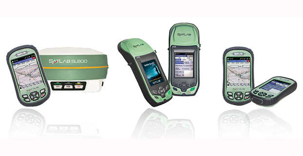
Satlab products include (from left) the SL600 6G GNSS receiver, the SL300 6G GNSS receiver, and the SL55 controller. Photo: Satlab Geosolutions AB
Swedish-based survey and GIS equipment maker Satlab Geosolutions AB has expanded into the U.S. and Americas with the creation of a new sister company Satlab Geosolutions (USA), Inc., based in Scottsdale, Arizona. Phil Gabriel has been named managing director of the USA office.
Setting up a formal base of operations in the U.S. will allow Satlab to better service their clients and expand their customer base in the U.S., Canada, Mexico and Latin America, a company release said. As past president of Hemisphere GNSS, Gabriel brings to the team his many years of experience in the survey, GIS, GNSS, machine control, marine and navigation industries, Satlab said.
The U.S. location will sell, support and service the new product lineup being introduced at InterGeo in Berlin, Germany, on October 7. Satlab is seeking dealers to expand its business throughout the Americas.
“The addition of a U.S. office is an exciting next step for us, after successful expansion into Turkey and the Czech Republic in the last few years,” said Bjorn Agardh, CEO of Satlab Geosolutions AB.
“Our products have been well received and continue to perform extremely well,” added Birol Gucluer, CTO and partner of Satlab.
“I’m excited to join Bjorn and Birol, extending their success by ensuring their high standards in customer service are maintained here in the Americas,” Gabriel said.
Satlab invites Survey and GIS dealers to meet the expanded team at InterGeo October 7-9 in Berlin, where they will be introducing several new models of their popular receivers and handhelds.
Lori Thompson with Exelis Inc. gives updates about the company at the 2014 ION GNSS+ Conference September 9-12 in Tampa, Florida. The company is celebrating more than 700 years of on-orbit performance.
More than 50 million people in the United States live in poverty. Explore the Poverty in America maps to learn more about the levels of poverty in your state and city.
Through the use of storytelling, videos, and interactive maps, Esri’s map provides a look at one method of measuring global poverty. This measure, called the Multidimensional Poverty Index (MPI), addresses poverty through an integrative approach.
Summer 2014 will be one that the €6.3 billion (US$8.2 billion) Galileo GNSS programme will need to chalk down to experience and hope to move on from. At the time of my last EAGER column, we were starting to get a hint that one of the four in-orbit Galileo IOV satellites was not functioning. We now know that it has suffered a catastrophic power failure.
And in August, celebrations for a successful launch of the first two Galileo FOC satellites, named Doresa and Milena, quickly went sour when it became clear that they had suffered an anomaly during launch. And a very big anomaly at that.
We are still awaiting the preliminary results from the inquiry set up by the European Space Agency (ESA), the European Commission, and the rocket’s operator Arianespace. It is hoped that the results of the inquiry board will be available at the end of September.
ESA spokesperson Franco Bonacina informs me that on the satellite side, ESA’s teams at the ESOC control centre are investigating the possibility of partially raising or modifying the orbit of the two satellites, which are fully under control and in good health. They are also considering performing some software adaptations on board the spacecraft and at ground station level to try and make them “be seen” as operational satellites and able to provide operational services within the Galileo system. All this is still “work in progress” and it will take a few more weeks to be fully evaluated and put into practice.
So, what went wrong?
In the absence of firm conclusions from the inquiry, the rumour mill has been running at full throttle with the wide range of theories from cock-up to conspiracy.
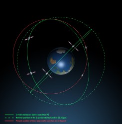
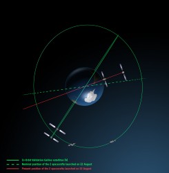
What we do know is that the Galileo craft were supposed to be launched by a Soyuz-Fregat rocket into a circular orbit 23,222 kilometres above the Earth and angled at 56 degrees to the planet’s equator. The initial launch from Kourou, French Guiana, on August 22 seemed to be smooth and nominal, but something went wrong in the final stages of the flight, and the two satellites were placed in an elliptical orbit varying from more than 2,000 kilometres too high to nearly 10,000 kilometres too low and also tilted by about 5 degrees from the intended plane.
Galileo orbits viewed side-on.
Galileo orbits viewed from above.
The most plausible explanation for the anomaly is that the Soyuz – Fregat upper stage suffered a control malfunction at some point before its final orbital injection burn. So although the rocket engine seems to have fired correctly, the craft wasn’t pointing in the right direction.
In fact, I am told that a likely mechanical root cause for the anomaly in the Fregat stage has been identified by the inquiry committee; however, more information is being gathered and further technical analysis is required to verify this.
Can anything be done?
Doresa and Milena do not have enough fuel on board to achieve the correct orbit for full Galileo operations.
Some interesting solutions have been proposed to launch a rescue mission to drag the errant satellites into their correct orbit, but that could be a slow, risky and expensive exercise. So could the satellites be useful in situ?
For most GNSS uses, the answer is probably no. Despite the fact that the satellites themselves are apparently working perfectly, in a safe state, correctly pointing towards the Sun, properly powered and fully under control of the ESA team, their elliptical orbit does not conform with Galileo’s standardized data format. For example, the value that represents the shape of the satellites’ orbit is too big to be expressed within the allotted bit limit for that parameter.
Marco Falcone, ESA’s Galileo system manager, says his team have been working intensely to determine if the satellites can be at least partially recovered. Among the considerations are the flight dynamics of moving the two spacecraft and the impact of the radiation they are experiencing in their current location, which can shorten the satellite’s lifetime. “It’s very dangerous for the satellite,” admits Falcone.
Another unknown is the timing performance of the satellites’ rubidium frequency and hydrogen maser given the relativistic effects of their orbit. Signal issues, such as the navigation message almanac, also must be considered before the FOC satellites can be introduced into operation, Falcone said.
Good for geoscience?
But according to fellow GPS World contributor Richard Langley of the University of New Brunswick, the situation is more hopeful for scientists wanting to use Galileo-derived data in their research. Quoted in an article in leading science journal Nature, Richard says that researchers tracking GNSS satellites via the IGS global network of ground stations combine that information with the timing data transmitted by the satellites themselves and could use it to measure changes in the position of points on the ground much smaller than the one-metre margin of error for standard navigation-system receivers. This level of precision is good enough to detect millimetres of movement in tectonic plates, for example.
This reminded me of a presentation by a team of Italian scientists I saw recently. The VADASE (Variometric Approach for Displacements Analysis Stand-alone Engine) project uses a novel strategy consisting of an algorithm able to perform real-time retrieval and estimation of displacement and waveforms based on high-frequency (1 Hz or more) carrier phase observations collected by a stand-alone GNSS receiver. The algorithm works with broadcast data (satellite clocks and orbits), requires very simple hardware, and has demonstrated potential application in real-world situations such as earthquake risk assessment (and related early-warning systems for tsunamis) and structural monitoring (see citations below). VADASE had already achieved a Galileo-only displacement solution using the four IOV satellites in orbit.
I contacted Gabriele Colosimo at Rome’s “Sapienza” University, and he confirmed that, although the satellites could not be used for direct gravimetric studies that require a very low orbit (below 1,000 km), the data from Doresa and Milena could be used to estimate displacements of GNSS receivers. He and the VADASE team think that a slight adjustment in their algorithm might be needed depending on the exact orbit parameters of the satellites, but the data would be useable without any significant change in orbit being required.
Gabriele also thinks that the data could be used to usefully contribute to studies in fields such as troposphere studies and GNSS reflectometry, as well as for geodynamic and seismic monitoring using GNSS.
Munich Masters
Hopefully the mystery of Doresa and Milena’s anomaly will have been resolved by October 23, when the 2014 European Satellite Navigation Competition (ESNC) awards ceremony takes place in Berlin in conjunction with the two-day Satellite Masters Conference.
But the real prize for the European GNSS community would be a full explanation of the recent Galileo issues, and how they are being resolved, and a clear statement and timeline on the future deployment and implementation of this flagship programme.
A bientôt – as they say in these parts
Citations
G.Colosimo, M. Crespi and A.Mazzoni, “Real-time GPS Seismology with a stand-alone receiver: A preliminary feasibility demonstration,” Journal of Geophysical Research, vol 116, doi: 10.1029/2010JB007941
M. Branzanti, G.Colosimo, M.Crespi and A.Mazzoni, “GPS near-real-time coseismic displacements for the great Tohoku-oki earthquake,” IEEE Geoscience and Remote Sensing Letters, vol 99, doi: 10.1109/LGRS.2012.2207704
Darren McCarthy, Rohde & Schwarz, gives GPS World a booth tour of its GNSS solutions, avionics gear and interference hunting solutions while at the 2014 ION GNSS+ Conference, held September 9-12 in Tampa, Florida.
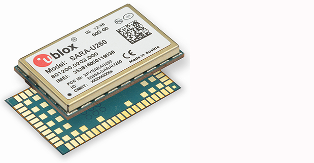
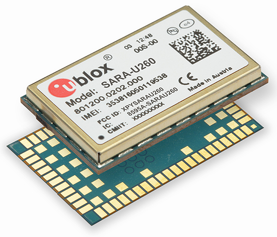
Swiss u‑blox says that its SARA-U260 dual-band 3G/2G module has achieved AT&T network compatible status.
The certification allows customers to design SARA-U260 modems into M2M devices operating over AT&T’s extensive 3G network in the USA. Typical applications include small tracking boxes, usage-based insurance devices, smart metering, wearable electronics, and connected fitness watches.
SARA-U260 is a complete 3G/2G voice/data module for applications that still require roaming ability with 2G using AT&T’s extensive 3G network coverage. The SARA-U260 provides full voice and data capability as well as a full suite of IP protocol stacks. The module features have been selected to give customers specific features they need for telematics units, handheld devices, communications modules, point-of-sale terminals, vehicle “black boxes,” and utility meters.
SARA-U260 provides efficient and cost-effective mobile connectivity in a miniature 16 x 26 mm2 LGA form factor. The module is pin-compatible with SARA-G3 GSM/GPRS modules, as well as layout-compatible with LISA-U2 (HSPA) and TOBY-L2LTE modules to support future-proof 4G LTE designs.
All SARA modules share the same form-factor and footprint and are designed based on u-blox’ “nested design” philosophy. This allows engineers to develop one hardware/software platform to support GSM/GPRS, HSPA, or LTE, depending on their end customer requirements.
SARA-U260 hosts multiple embedded IP protocols, such as TCP/IP, UDP/IP, HTTP, and FTP. In-band modem support for automotive emergency calls like eCall and ERA/GLONASS are also integrated. With extremely low-power consumption, the SARA-U260 is designed for battery-powered and handheld devices.
With direct A-GPS support for accelerated positioning and u-blox’ CellLocate hybrid positioning technology, SARA-U260 is designed to match u-blox advanced GNSS positioning capabilities, including indoor positioning.
“u-blox is proud that AT&T certified our SARA-U260 module for its network,” said Nikolaos Papadopoulos, president of u-blox America. “Our robust voice and data modules deliver powerful 3G connectivity with 2G fallback in the smallest package on the market, at a price that customers recently paid for a 2G module.”
For Europe and Asia, u-blox also offers the pin- and software compatible certified version SARA-U270.
Mark Wilson, IFEN Inc., demonstrates the company’s new XS3 software receiver – which succeeds the scientific GNSS software-receiver SX-NSR – at the the 2014 ION GNSS+ Conference September 9-12 in Tampa, Florida.
“We expect that the North will finish development of a new precision-guided bomb in the near future because we’ve detected signs that the North has been conducting tests for a few years now,” a military source in South Korea told the newspaper.
The JDAM GPS-guided bomb has a range of 28 kilometers and accuracy of about 13 meters. North Korea’s new bomb is believed to have a range of 10 kilometers.
According to TheChosun Ilbo, military authorities say they detected signs of a fighter jet dropping the bomb over a testing ground in North Korea’s Hwanghae Province earlier this year.
The South Korean Air Force has a variety of precision bombs, including a device with a range of 100 kilometers.
The Indian Space Research Organization (ISRO) has released Version 1 of the Indian Regional Navigational Satellite System (IRNSS) Signal in Space Interface Control Document for the Standard Positioning Service.
The document provides information on the signals and structures of the IRNSS system, including signal modulations, frequency bands, received power levels, the data structures and their interpretations, and user algorithms.
According to ISRO, the document is being released to the public to facilitate research and development and to aid the commercial use of the IRNSS signals for navigation-based applications.
Registration is required for ICD download access at a new IRNSS website. At the moment, only the ICD is available at this website.
The next IRNSS satellite launch is scheduled for the second week of October. The most recent launch was in April, of the second IRNSS satellite, IRNSS-1B.
IRNSS is an independent regional navigation satellite system being developed by India. It is designed to provide accurate position information service to users in India and the region extending up to 1,500 kilometers from its boundary. IRNSS will provide two types of service: Standard Positioning Service (SPS) and Restricted Service (RS). It is expected to provide a position accuracy of better than 20 meters in the primary service area.
Did you know the largest GIS conference in the world is held in Germany every year? Last October, more than 16,000 geospatial geeks traveled to Germany to attend the InterGeo Conference. In just a few short weeks, Geospatial Solutions’ staff will travel to Berlin and mix it up with the world’s leading geogeeks. If you want to see the latest and greatest GIS technology, both hardware and software, it is the best show in the world, bar none.
The second largest GIS conference in the world is the Esri International User Conference. It’s a great conference, with one major caveat; it’s a user conference for Esri users. Competitors and perceived competitors are not invited.
InterGeo is open to any company that can afford an exhibit booth. That’s one major difference. The other major difference is that there are very few technical sessions. That means all 16,000+ attendees are wandering around the exhibits. The exhibit aisles are packed with people, all the time for all three days, and the energy is fantastic.
The InterGeo conference is an eye-opener for North Americans who attend for the first time. This is because they will see a much wider variety of brands than they are exposed to in North America and, in many cases, they will see products with lower price points. It’s all about marketing. The African, Asian and European markets won’t pay as much for products as North Americans will, and seeing how 83% of the InterGeo attendees are from Europe, you can imagine how the products are marketed. Only 2.4% of the 2013 attendees were from North America. Following is a map illustrating where last year’s attendees traveled from:
InterGeo 2013 attendance.
Not only are there commercial exhibits, but also technology displays such as this mapping machine from the 19th century that was displayed during the 2012 InterGeo Conference.
At this year’s show, we expect to see a lot of UAVs. Last year, there were 25 exhibits showing UAVs. This year, I expect that number to double as new UAVs are being introduced almost weekly and, unlike in the U.S., UAVs are legal to fly in many countries of the world.
I also expect to see a wider variety of RTK GNSS receivers, at more competitive prices than last year.
Stay tuned to Geospatial Solutions and GPS World magazine staff as we descend into Berlin in a couple of weeks. Expect lots of photos, video recordings and write-ups of the event. Remember to follow me on Twitter for real-time news and photos.
Qian Haizhong of Harxon Corporation shares on the company’s new product, the Helix antenna, at the 2014 ION GNSS+ Conference September 9-12 in Tampa, Florida.
Septentrio subsidiary Altus Positioning Systems is now shipping demo units of its latest GNSS RTK receiver, the APS-NR2. The high-performance receiver incorporates GNSS and wireless technology into a sleek and compact design to provide an intelligent network rover with on-board configuration and extended operation time, the company said.
Based on a low-power and small-footprint OEM GNSS receiver, the APS-NR2 offers robust RTK while consuming less power for longer operation time on battery power.
For easy configuration and status monitoring, the APS-NR2 features an on-board web interface accessible via Wi-Fi. This makes the APS-NR2 configurable from any device that has a browser and Wi-Fi, and with any operating system. Real-time data is streamed over Bluetooth for a completely cable-free operation.
A 3.5G Quad-band GSM/GPRS/EDGE + HSPA cellular modem supports reliable RTK network connectivity with an intelligent reconnect feature. In addition to standard Li-Ion battery chargers and USB cable interface, the design includes on-board USB battery recharge. At 1.5 lbs., the APS-NR2 weighs the same as a dozen glazed doughnuts.
“It all adds up to the world’s most versatile RTK rover that provides more productivity and less downtime in the field,” said Vancans. “The APS-NR2 raises the bar and sets a new standard for the state-of-the-art in high-precision surveying and geolocation, leveraging the power and convenience of mobile tablet platforms.” Units are expected to ship starting October 20.