

Blog

  • China to Join Effort on Aircraft Satnav Standards

    China to Join Effort on Aircraft Satnav Standards

    EGNOS is Europe’s first venture into satellite navigation. EGNOS broadcasts augmented information through a trio of geostationary satellites linked to a network of monitoring ground stations, to sharpen the accuracy and reliability of GPS signals across the continent.
    EGNOS is Europe’s first venture into satellite navigation. EGNOS broadcasts augmented information through a trio of geostationary satellites linked to a network of monitoring ground stations, to sharpen the accuracy and reliability of GPS signals across the continent. Photo: EGNOS

    Europe’s EGNOS augmentation system sharpens the accuracy and reliability of GPS signals so they can safely be used for landing approaches across a growing number of European airports. But aviation is a global enterprise — so the aim is to develop a seamless network of augmentation systems in future.

    That is the task of an international group of experts, the Satellite Based Augmentation Systems (SBAS) Interoperability Working Group (IWG), whose 27th  meeting took place in Tampa, Florida, September 8-10, hosted by the Institute of Navigation.

    Satellite augmentation systems combine dedicated ground stations and satellite transponders to sharpen satnav accuracy and provide integrity data — providing continuously updated reliability levels — across given geographical regions. These systems are based on GPS for now, but plans are to move to a multi-constellation design in the post-2020 era, making use of Europe’s Galileo, China’s Beidou and Russia’s GLONASS systems as well.

    SBAS providers from around the globe gathered at Tampa, Florida, for the latest meeting of the SBAS Interoperability Working Group September 8-10. IWG 27 was hosted by the Institute of Navigation.
    SBAS providers from around the globe gathered at Tampa, Florida, for the latest meeting of the SBAS Interoperability Working Group September 8-10. IWG 27 was hosted by the Institute of Navigation. Photo: SBAS
    SBAS systems enhance any type of location-based satnav use, but in practice, aviation is the main driver. The ESA-developed European Geostationary Navigation Overlay Service, EGNOS, commenced its general-public Open Service in 2009, with the Safety-of-Life Service for aircraft vertical landing approaches following in 2011.

    For next-generation SBAS systems, the IWG is designing a multi-constellation and dual-frequency standard for heightened accuracy and reliability, building up to offering SBAS coverage on a worldwide basis.

    Didier Flament, representing ESA — which co-chaired this IWG meeting with the U.S. Federal Aviation Authority — commented: “Among the achievements of the Tampa IWG has been the presentation of an ongoing review of a standard message definition for the new and second SBAS channel — known as L5 — of the second-generation SBAS system, to be used along with the current L1 signal.

    ASECNA Member States.
    ASECNA Member States.
    “A single definition coordinated between ESA and the European Commission on one side and the U.S. Federal Aviation Administration on the other is progressing. The formal IWG review loop has  started, with the aim of finalizing the convergence for early 2015. The aim is to have it ready to submit to the international SBAS standardization bodies — the International Civil Aviation Organization (ICAO), the U.S. Radio Technical Commission for Aeronautics and the European Organization for Civil Aviation Equipment — in the first quarter of next year.”

    The meeting also introduced two new SBAS development projects, adding to the five existing projects presented at IWG 26. The first was presented by the Agency for Air Navigation Safety in western Africa and Madagascar (ASECNA), a public international organization with 18 member states.
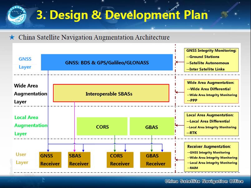
    China's BeiDou SBAS development plan, presented at IWG 27 in September 2014.
    China’s BeiDou SBAS development plan, presented at IWG 27 in September 2014.

    ASECNA’s project aims to take a two-step approach, commencing with EGNOS-style vertical landing guidance for selected airports, based on EGNOS constituents, with a tentative schedule of 2018, moving to upgrade to the dual-frequency multi-constellation service across the whole of ASECNA airspace after 2020.

    The second new project is China’s own BeiDou SBAS. After discussions at ICAO level, China has committed to delivering SBAS services over China that are fully compliant with ICAO standards.

    “This new plan has been highly welcomed by the aviation community and other SBAS providers,” Didier said. “Chinese representatives have also confirmed their intention to become part of the SBAS IWG and contribute to the work done to finalise the future standard.”

    The follow-up IWG meeting will take place in February 2015 and will be hosted by ASECNA in Dakar, Senegal.

    About EGNOS

    EGNOS, the European Geostationary Navigation Overlay Service, is Europe’s first venture into satellite navigation. Its development was managed by the European Space Agency (ESA) under a tripartite agreement with the European Commission (EC) and the European Organization for the Safety of Air Navigation (Eurocontrol).

    The ownership of the EGNOS assets was transferred from ESA to the EC in April 2009 and EGNOS officially entered service on October 1, 2009. The service is delivered, through a contract with the European GNSS Service Agency (GSA), by the European Satellite Services Provider, ESSP SaS, founded by seven air navigation service providers. ESA is the design and procurement agent for EGNOS on behalf of the EC.

     

  • ION GNSS+ 2014: The Boeing Company

    Larry Davidoff, director of advanced navigation systems at The Boeing Company, highlights the company’s Position, Navigation and Timing (PNT) system solutions at ION GNSS+ September 9-12 in Tampa, Florida. Jeffrey Goldstein shares digital navigation technology, which includes a GPS-enabled Jeppesen aeronautical aviation chart.

  • Janam Introduces Powerful Rugged Tablet

    Janam Introduces Powerful Rugged Tablet


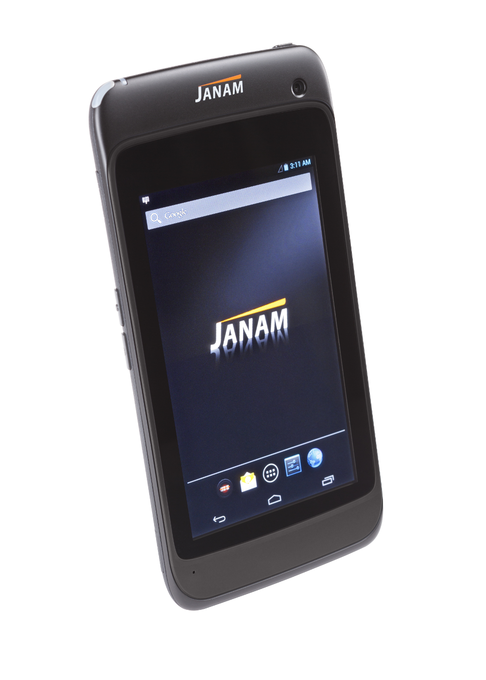
    Janam-xt1
    Photo: Janam Technologies LLC

    Janam Technologies LLC, a provider of rugged mobile computers that scan barcodes and communicate wirelessly, has launched XT1, a powerful rugged tablet for the mobile workforce. The XT1 rugged mini-tablet is Janam’s first device to support the Android operating system, and is built to meet the diverse needs and demanding requirements of enterprise and government customers.

    The XT1 combines best-in-class technologies with a sleek and rugged form factor, providing mobile workers with the information they need to make better informed decisions, increase customer satisfaction, and improve operational efficiencies, the company said. Equipped with integrated 2D barcode scanning technology to eliminate the challenges often associated with camera scanners or bulky sled attachments, the XT1 is designed to improve worker productivity in field sales, field service, healthcare, hospitality and retail markets.

    “Many enterprise customers require more screen viewability than traditional PDAs or handheld computers offer, yet full-display rugged tablets are large, thick, heavy and unwieldy,” said Harry B. Lerner, CEO of Janam. “Janam resolves this dilemma. The XT1 blends cutting-edge technologies most often found in consumer phones with mission-critical key features that enterprises need such as ruggedness, sealing, barcode scanning and rapid battery recharging, among others. The result is a sleek, lightweight, rugged mini-tablet that delivers superior performance without sacrificing usability.”

    In addition to 4G-ready UMTS/HSDPA/HSUPA/GSM wireless wide-area network communication, the XT1 is equipped with 802.11a/b/g/n dual-band WLAN for access to the information mobile workers need to get the job done, inside and outside the four walls. With IP54 sealing and the ability to withstand repeated three-foot drops to concrete, the XT1 delivers the reliability needed to excel in the most demanding environments, Janam said.

    XT1 features include:
    Android 4.2 operating system
    TI OMAP4470 @ 1.5GHz
    5.9-inch WVGA TFT capacitive touchscreen
    High-performance 2D data capture
    Multiple 3-foot/1-meter drops to concrete
    IP54 sealing against environmental elements
    Embedded RFID and NFC capabilities
    Optional 3G/4G WWAN technology (UMTS/HSDPA/HSUPA/GSM)
    1GB RAM, 16GB ROM
    Wi-Fi 802.11a/b/g/n
    Bluetooth 4.0 (BLE)
    High-sensitivity GPS and Assisted GPS
    Motion sensing accelerometer
    Front/rear cameras
    User-accessible microSD card slot
    3.5mm headset jack
    MicroUSB connector
    3000mAh rechargeable LiIon battery

  • PND Shipments Fell to 22M Units, Despite Nav User Increase

    According to a new research report from the analyst firm Berg Insight, global shipments of personal navigation devices (PNDs) declined from 28 million units in 2012 to 22 million units in 2013. There are signs that the decline is slowing and some emerging markets still experience growth.

    However, on the whole, the PND market is set for a continued downturn on a global basis. Berg Insight forecasts that PND shipments will decline to only 10 million units worldwide in 2019.

    A number of developments are affecting the PND market. Retailers have reduced shelf space and marketing for PNDs in favor of other consumer electronics products. Competition from other navigation solutions, especially navigation apps, is also intensifying.

    Over time, PNDs will also face further competition from in-dash navigation systems as more car brands launch low-cost systems. Moreover, the installed base of PNDs is already high, and replacement cycles are likely to be prolonged since PNDs have matured considerably and many devices are now sold with lifetime map updates, giving users less reason to replace their existing devices as frequently.

    The user experience for handset-based navigation apps is now improving through better integration in the car. Some vendors have released NFC-enabled car mounts enabling the owner to configure the handset to turn on the GPS and launch a navigation app when the phone is placed in the mount. A majority of car manufacturers have also started to offer smartphone integration solutions that connect the vehicle’s infotainment system with the user’s smartphone via Bluetooth, Wi-Fi, USB or HDMI. It is then possible to display and control smartphone apps using the touchscreen and controls in the car.

    Higher smartphone adoption along with broader availability of low-cost and free navigation apps are important factors for the continued increase in usage of mobile navigation services worldwide. “The number of mobile subscribers worldwide using a turn-by-turn navigation app on their handset at least once per month grew from 150 million in 2012 to 180 million in 2013,” said André Malm, senior analyst, Berg Insight. He adds that in most markets, smartphones from major vendors now come bundled with free navigation apps.

    The leading navigation service providers on a global basis include Google, Apple, Telenav, Appello Systems, Nokia and Garmin. Examples of major local players include AutoNavi and Careland in China, SK Planet in South Korea, NAVITIME and ZENRIN in Japan, as well as Navitel and Yandex in Russia.

    Despite increasing competition from free navigation apps, many mobile operators are still marketing their own navigation services developed by companies such as Telenav, TeleCommunication Systems and Appello Systems. “App developers and operators are now trying to monetize navigation apps by introducing premium features and advertising,” said Malm. “Developers are also forced to reduce costs as competition increases, for instance by adopting OpenStreetMap data to reduce map licensing fees.”

  • Digital Coast Act Introduced in U.S. Senate

    A bill to establish a “Digital Coast” program whereby the National Oceanic and Atmospheric Administration (NOAA) develops a coordinated and comprehensive national mapping effort for coastal, state and territorial waters of the United States, has been introduced in the U.S. Senate, earning praise from MAPPS (the national association of private sector geospatial firms).

    More than half of all Americans, 153 million people, live on or near a coast, and an additional 12 million are expected to move to the coasts over the next decade. Yet, despite this population density and economic development, much of the 95,000 miles of U.S. shoreline does not have current, accurate maps and geospatial information; moreover, much of what does exist pre-dates the 1970s.

    “The Digital Coast Act is needed to realize the concept of a Digital Coast as recommended by the National Academy of Sciences (NAS),” said MAPPS Executive Director John Palatiello. “The Digital Coast Act provides an opportunity to help America’s ocean, coastal and shoreline areas by addressing issues raised by the U.S. Oceans Commission, the Pew Commission, as well as several NAS reports, all of which have highlighted the need for surveying, charting, remote sensing, and geospatial data of America’s coasts, harbors, ports, shorelines and ocean resources critical to the nation’s most basic economic and recreational activities, to smartly conserve a fragile environment.”

    “Greater emphasis has been paid to monitoring sea-level rise, coastal conservation and emergency preparedness and response in the wake of natural and manmade disasters,” MAPPS President Jeff Lower, said. “This Digital Coast Act will coordinate the pooling of resources from multiple agencies (federal, state, and local) and other stakeholders to map the various needs once, and then utilize and apply the high-quality data and products numerous times, thus reducing taxpayer waste while maximizing the return on investment for all stakeholders.” 
    The Digital Coast is a geospatially enabled program to improve coordination and support work with stakeholders to identify geospatial priorities; improve coordination of coastal mapping and management activities; use standards and standardized methods for data acquisition, processing, and distribution to ensure broadest utility of data; promote best practices when applying geospatial data for coastal decision making; and contract for the collection and creation of quality non-navigation feature data sets to include: shoreline change, satellite and aerial imagery, land use and land cover maps, benthic habitat mapping, terrestrial topography, shallow water bathymetry, and submerged aquatic vegetation.

    U.S. Senator Tammy Baldwin of Wisconsin introduced the Digital Coast Act of 2014 on September 18. The bill compliments a bipartisan effort in the U.S. House of Representatives by C.A. “Dutch” Ruppersberger (D-MD) and Don Young (R-AK), cosponsors of Digital Coast Act, H.R 1382.

  • Aireon Plans Global Emergency Tracking Service for Aircraft

    Aireon LLC, developer of a space-based ADS-B global air traffic surveillance system, is planning the Aireon Aircraft Locating and Emergency Response Tracking (Aireon ALERT) service, a global emergency tracking service that will be provided free of charge to the aviation community beginning in 2017. The Aireon ALERT service will allow rescue agencies to request the location and last flight track of any 1090-MHz ADS-B equipped aircraft flying in airspace currently without surveillance.

    “A comprehensive, global aircraft tracking solution is essential in emergency situations, as evidenced by MH370 earlier this year and Air France 447 in 2009,” said Don Thoma, president and CEO, Aireon. “Aireon is being deployed to improve the efficiency and safety of aircraft operations in oceanic and unsurveilled airspace. The same technology behind these efficiency and safety gains can also make a significant difference in providing quick, accurate information in emergency situations. With one global view of ADS-B equipped aircraft, Aireon ALERT will provide accurate and real-time tracking data immediately to authorized search-and-rescue operations, without requiring airlines to equip aircraft with new avionics or the ANSPs and authorities to deploy new systems.”

    Aireon is deploying a global space-based ADS-B surveillance capability providing direct air traffic controller visibility of flights operating in oceanic or remote airspace, focused on improving the efficiency and safety of aircraft operations. When Aireon is fully operational, anticipated for 2017, it will create a powerful platform capable of tracking ADS-B equipped aircraft around the globe in real time.

    The Aireon ALERT service will be available soon after Aireon’s full deployment and will be provided through a 24/7 application and emergency call center. Historical track data will be available to pre-authorized users, including ANSPs, airlines, and search-and-rescue authorities, through Aireon ALERT soon after controller communications are lost with an aircraft. The system can also provide real-time tracking of aircraft in distress, provided ADS-B transmissions are still operational.

    “Tracking of aircraft in emergency and search-and-rescue situations is a complex issue,” said Cyriel Kronenburg, vice president sales and marketing for Aireon. “We plan to engage the various aviation stakeholders including the airlines, ANSPs, regulators, and search-and-rescue organizations over the next 12 months to define the technical, operational, and legal details of providing this data in emergency situations.”

    “We anticipate support from the world’s airlines for the approach taken by Aireon for emergency tracking,” said John Crichton, president and CEO of NAV CANADA. “Airlines already stand to gain over $125 million per year in fuel savings in the North Atlantic alone by using Aireon’s space-based surveillance service. The Aireon ALERT public service offers an additional benefit, free of charge, ensuring that ADS-B equipped aircraft can be tracked anywhere in the world, even in airspace managed by ANSPs that have not subscribed to the Aireon service.”

    Aireon is a joint venture among Iridium Communications Inc., NAV CANADA, ENAV, IAA, and Naviair, established to launch the Aireon system by hosting ADS-B receiver payloads on Iridium NEXT, Iridium’s second-generation satellite constellation, scheduled for first launch in 2015. This new capability will extend air traffic surveillance to the entire planet and increase the safety and efficiency of air travel over oceanic and remote regions.

  • GPS III Payload Arrives, Platform Acceptance Tests Next

    Enter GPS III. The long-awaited navigation payload for the next-generation satellite pulled into its new temporary home over the September 13 weekend, the Lockheed Martin Space Systems facility in Littleton, Colorado. Lockheed is the U.S. Air Force’s  prime contractor for the first batch of eight GPS III satellites.

    Exelis Geospatial Systems has committed to delivering the payloads for the second, third, and fourth GPS III satellites “right on the heels” of the first, according to Gen. John Hyten, commander of Air Force Space Command. “If that’s the case, in the not-too-distant future GPS III will be in good shape,” he added. The first GPS III launch is now scheduled for 2016.

    Exelis has built GPS payloads since the beginning of the program, but found new challenges over the last two years posed by advanced features of the modernized version. “First-time development and integration issues, including design changes to eliminate signal crosstalk” have set back the schedule.

    According to reports, Lockheed Martin has a group of initial platforms readied on its production line to take the incoming payloads.

    Still ahead, completion of acceptance testing following integration with the first satellite platform.

    Earlier this year, Lockheed Martin issued a request for information on alternate payload providers, and received responses from five companies. In June, the Air Force issued a call for contractors interested in building the next batch of GPS IIIs. Northrop Grumman and Boeing have responded.

  • Seventh GPS IIF Satellite Set to Healthy and Usable

    The seventh GPS-IIF satellite, SVN-68/PRN-09, launched on August 2, was set to healthy and usable Sunday night, according to Rick Hamilton, CGSIC executive secretariat of the USCG Navigation Center. The change brings the number of satellites transmitting the L2C signal to 13, and those transmitting the L5 signal to seven.

    The next GPS-IIF satellite, IIF-8/SVN-69, is tentatively scheduled for launch on October  29.

    Below is the full text of the Notice Advisory to Navstar Users (NANU).


    NOTICE ADVISORY TO NAVSTAR USERS (NANU) 2014071

    SUBJ: SVN68 (PRN09) USABLE JDAY 260/2026

    1.     NANU TYPE: USABINIT

            NANU NUMBER: 2014071

            NANU DTG: 172024Z SEP 2014

            REFERENCE NANU: N/A

            REF NANU DTG: N/A

            SVN: 68

            PRN: 09

            START JDAY: 260

            START TIME ZULU: 2026

            START CALENDAR DATE: 17 SEP 2014

            STOP JDAY: N/A

            STOP TIME ZULU: N/A

            STOP CALENDAR DATE: N/A

    2.  CONDITION: GPS SATELLITE SVN68 (PRN09) WAS USABLE AS OF JDAY 260

         (17 SEP 2014) BEGINNING 2026 ZULU.

    3.  POC: CIVILIAN – NAVCEN AT 703-313-5900, HTTP://WWW.NAVCEN.USCG.GOV

         MILITARY – GPS OPERATIONS CENTER at HTTPS://GPS.AFSPC.AF.MIL/GPSOC, DSN 560-2541, COMM 719-567-2541, [email protected]HTTPS://GPS.AFSPC.AF.MIL

         MILITARY ALTERNATE – JOINT SPACE OPERATIONS CENTER, DSN 276-3514, COMM 805-606-3514, [email protected]

  • ION GNSS+ 2014: Antcom Corporation

    Robert Dumont, international sales manager at Antcom Corporation, discusses the rugged GNSS and communication antennas as well as the microwave accessories Antcom manufactures while at the 2014 ION GNSS+ Conference September 9-12 in Tampa, Florida.

  • Esri User Conference Seeks Papers, Presenters

    The Esri User Conference has issued a call for papers for its 2015 event, scheduled for July 20-24 at the San Diego Convention Center. “Every year, ArcGIS users tell stories of inspired solutions, insightful best practices, time-saving apps, and game-changing maps,” conference organizers said in a statement. “The most innovative and influential GIS work comes into focus at the Esri User Conference. You could tell your GIS story at the 2015 Esri UC. This is a chance to show your peers what you can do.”

    The 2015 call for papers covers 90+ session topics highlighting GIS solutions today and in the future. The user sessions combined with the UC plenary and lightning talk presentations will bring more than 900 speakers together covering more than 260 sessions dedicated to the success and advancement of geospatial technology.

    Paper sessions help attract peer recognition and provide valuable feedback, organizers said. “As an Esri UC presenter, you will gain recognition and exposure to over 16,000 Esri users who represent over 26 unique and diverse fields, coming together with the common goal of answering today’s challenges with tomorrow’s GIS to create a better world.”

    Deadline for submitting papers is October 31. Full details are on the Esri UC website.

  • Talks on Placing GLONASS Stations in the U.S. Not Renewed

    RIA Novosti is reporting that negotiations regarding the placement of a differential correction and monitoring GLONASS station in the United States have not yet been renewed. The news agency quotes remarks by Grigory Stupak, first deputy general designer of Russian space systems, during the Fourth International School on Satellite Navigation.

    In all, 40-50 GLONASS stations are planned for placement around the world, Stupak said. “As for the United States, we now consider the option of placing a station in Alaska, but the lack of it does not significantly affect the performance of our system,” he said, adding that Russia has worked with the southern African region and South America on placement of GLONASS stations, with one station in Brazil already operational. “There also have Cuban colleagues to host GLONASS stations,” he said.

    According to Stupak, taking into account developments in the world, it does not make sense to force the negotiation situation by placing a station in Alaska.

    GLONASS Satellites Based Mainly on Russian Component Base
    The prevailing share of the payload for both GLONASS-M and GLONASS-K spacecraft is created by JSC Russian Space Systems (CSW), but contains an element base of both domestic and foreign production, Stupak said, according to the the GLONASS Herald.

    “If you take onboard equipment [for] GLONASS-M, a significant portion of its designers develop mainly on electronic components of domestic production,” Stupak said.

    Including onboard equipment, while a significant portion of the GLONASS-M design is based on domestic electronic components, for the GLONASS-K, most of the components are Russian, but some foreign components are also being used.

  • KVH Introduces Fiber-Optic Gyro IMUs for Demanding Applications

    KVH Introduces Fiber-Optic Gyro IMUs for Demanding Applications

    KVH_1775_IMU-W KVH Industries, Inc.
    Photo: KVH Industries, Inc.

    KVH Industries, Inc., has introduced the 1725 Inertial Measurement Unit (IMU) and the 1775 IMU, advanced sensors designed to be integrated into the most demanding stabilization, pointing, and navigation applications. These two new products complement KVH’s successful 1750 IMU and create a complete range of choices for advanced six-degrees-of-freedom (DOF) sensors with enhanced performance. All three products utilize the E•Core ThinFiber technology of KVH’s DSP-1750 fiber-optic gyro (FOG).

    “With these three products, system designers and integrators now have a high-performance solution for every application — ranging from manned and unmanned commercial and defense platforms, optical equipment stabilization systems, and pipeline inspection equipment, to autonomous vehicle control and navigation,” said Jay Napoli, KVH’s vice president of FOG/OEM sales. “This line satisfies the performance, size, and price parameters for IMUs in a way that no competitor can match due to KVH’s control over the design and manufacturing process, from creating the fiber to integrating all of the IMU components into the final design. Maintaining complete control of this process, combined with our proprietary technologies, allows KVH to offer a winning combination of innovative solutions, superior quality, and affordable options for nearly every stabilization or guidance application.”

    The 1725 IMU features a flexible user interface, with user programmable data output rates from 1 to 1000 Hz. It delivers excellent FOG performance and stability at a price comparable to competitive MEMS-based IMUs. The 1725 IMU is designed for all platforms and navigation or stabilization systems where low cost, high-performance, and high bandwidth are critical for success.

    The 1775 IMU is a premium sensor designed to deliver the highest level of performance to meet the demands of platforms requiring superior performance in the most challenging environments. Providing ease of integration for designers of high-level inertial navigation, guidance, or stabilization systems, the 1775 IMU offers a flexible interface with user-programmable data output rates from 1 to 5000 Hz. It includes three axes of magnetometers for automatic gyro bias compensation even in the presence of strong magnetic fields. The 1775 IMU is designed for sophisticated systems and applications where very high bandwidth, low latency, and extreme stability are critical.

    Like KVH’s 1750 IMU, introduced in 2012, the 1725 IMU and the 1775 IMU incorporate three axes of KVH’s DSP-1750 FOG, a tiny high-performance FOG integrated with three axes of advanced accelerometer technology. All three IMUs provide excellent shock, vibration, and thermal performance, as well as a compact form factor, KVH said.

    KVH controls the entire production process, from creating its own specially designed polarization-maintaining optical fiber to packaging its gyros together in advanced systems for inertial measurement, inertial navigation, and attitude heading reference. As a result, KVH’s open-loop fiber optic gyros offer outstanding accuracy and excellent durability at a lower cost than competing systems, the company said.