Thomas Seiler, u-blox CEO, holds a drone with GPS embedded.
Several companies at CTIA Super Mobility Week, held in Las Vegas September 9–11, are attempting to find niche opportunities in the crowded machine-to-machine market — and Switzerland-based u-blox is no exception. The company is focusing on the mobile, industrial and consumer-location markets, said Thomas Seiler, u-blox CEO.
While Seiler says there is no one dominant market for u-blox, the fleet market has been very good for the company. In addition, asset tracking has been a good market, he said.
“We are also seeing consumer markets such as e-bikes, golf carts, commercial helicopters and drones growing,” Seiler said.
While many location companies are fretting about government regulation, u-blox is taking the position that most agency requirements have actually helped build the market. “Regulatory requirements have been driving business for us. The [National Highway Traffic Safety Administration] proposes that vehicles report location, speed and direction,” said Nikolaos Papadopoulos, u-blox America president. “The collision avoidance regulations have helped to create an ecosystem that drives business.”
The company recently rolled out its ODIN-W160 multi-radio module for automotive, industrial, medical and security applications.
Nick Papadopoulos, president of u-blox America, tells CTIA Super Mobility Week show-goers what they should see at the u-blox booth.
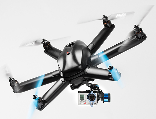
HEXO+, an autonomous flying camera system, by Squadrone Systems will exhibit at CES 2015. Photo: Squadrone Systems
The Consumer Electronics Association today announced the debut of the Unmanned Systems Marketplace at the 2015 International Consumer Electronics Show (CES). Owned and produced by CEA, the International CES is a gathering place for those who thrive on the business of consumer technologies. The 2015 CES is scheduled to run January 6-9, 2015, in Las Vegas, Nevada.
The Unmanned Systems Marketplace highlights the burgeoning technology in drones, unmanned aerial vehicles (UAVs), and other unmanned systems controlled by onboard computers or remotely from the ground. In its first year at the CES, the Unmanned Systems Marketplace is expected to cover 6,500 square feet of exhibit space with room for about 16 high-end commercial and consumer UAV technology companies.
According to CEA research, the global market for consumer drones will approach $130 million in revenue in 2015, increasing by 55 percent from 2014, with unit sales of consumer drones expected to reach 400,000. The revenue from drone sales is expected to easily exceed $1 billion in just five years.
“Drones and unmanned systems are being used to assist in a variety of applications, from aerial coverage for sports and real estate, to assistance in search and rescue and disaster relief missions,” said Karen Chupka, senior vice president, International CES and corporate business strategy, CEA. “We’re excited to introduce the Unmanned Systems Marketplace at the 2015 CES and witness how these unique tools are revolutionizing the way we capture and monitor our world.”
The Unmanned Systems Marketplace will be located at CES Tech East, in the Las Vegas Convention and World Trade Center (LVCC), South Hall 2. Tech East includes the LVCC, the Westgate Las Vegas , and Renaissance Las Vegas. Major exhibitors located within the Unmanned Systems Marketplace include AirDog, Squadrone, Trace, DJI, iRobot, Trace, Torquing Group DBA ZANO, Ecovacs, EHang, Autel, Pelican Products, and other brands.
The 2015 CES will feature 20 category-specific marketplaces highlighting innovation across diverse product areas. Companies interested in exhibiting in the Unmanned Systems Marketplace should contact Oleg Burdo at [email protected] or 703-907-5257.
Registration for the 2015 CES is open. For more information on the 2015 CES, visit CESweb.org.
GPS World/Geospatial Solutionsstaff will be reporting from InterGeo October 7-9. The massive trade show, held this year in Berlin, is considered the world’s leading conference trade fair for geodesy, geoinformation and land management. With more than 16,000 visitors from 80 countries, it is one of the key platforms for industry dialogue.
Staff members attending include GPS World Editor and Publisher Alan Cameron, Survey/GIS Editor Eric Gakstatter, and Digital Editor Joelle Harms. All three are accepting meeting invitations for companies interested in discussing their products and services. Contact [email protected].
Galileo’s first two full-operational capability (FOC) satellites have been in a safe state since August 28, under control from the European Space Agency’s (ESA’s) center in Darmstadt, Germany, despite having been released on August 22 into lower and elliptical orbits instead of the expected circular orbits.
ESA continues investigating the possible exploitation of the out-of-position satellites to maximum advantage, despite their unplanned injection orbits and within the limited propulsion capabilities. ESA specialists, supported by industry and France’s CNES space agency, are analyzing different scenarios that would yield maximum value for the program, and safeguard — as much as possible — the original mission objectives.
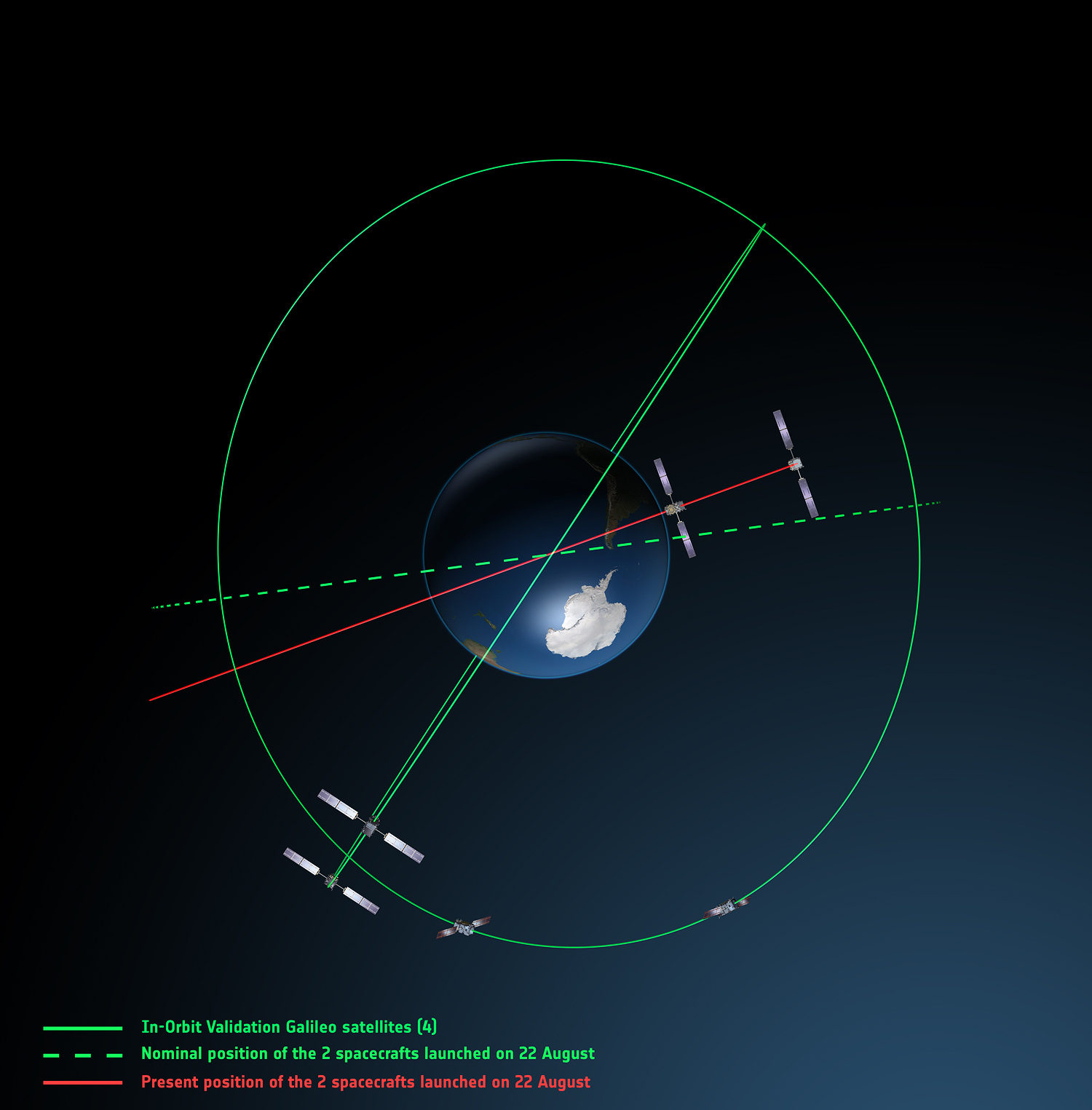
Galileo orbits viewed from above: Orbits of the fifth and sixth satellites in red, compared to their intended position in dashed green, and the position of the four satellites launched in 2011 and 2012 in solid green. This view looks down over the South Pole to illustrate how the inclination relative to the equator is less than intended. The satellites are in an elliptical rather than circular orbit, with a maximum altitude of about 25,900 km and a minimum altitude of about 13,700 km, compared to a planned circular orbit of 23,222 km altitude.
Experts representing the Galileo Program provided a frank and open update at the ION GNSS+ conference in Tampa on September 10, as reported by Richard Langley:
An inquiry board is looking into problem to find the root cause of the anomaly. The board has already met several times.
An intermediate report is due shortly; a final report and recommendations will come next month.
ESA is considering what can be done with the two satellites; ESA hopes to be able to use them operationally as much as possible.
ESA is also looking at the impact on the commercial Galileo service and the search-and-rescue service.
ESA is narrowing down the possible causes of the anomaly.
ESA is waiting for the enquiry board to report before deciding on when and how the next two satellites will be launched.
The payloads of the errant satellites are currently off.
ESA wants to try to raise the perigees of the satellites to get them out of the van Allan radiation belt as soon as possible to prevent damage to the satellites. Raising the perigrees will also to reduce the maximum Doppler frequency shift from 9.6 kHz to at least 6.8 kHz to allow receivers to easily acquire and track the satellites, but leave enough hydrazine for future station keeping.
ESA is looking at the almanac problem and whether unused bits in the Galileo navigation message might be able to support a special almanac for the satellites.
ESA is also looking at possible rephasing of the satellites to optimize their use with the other satellites in the constellation.
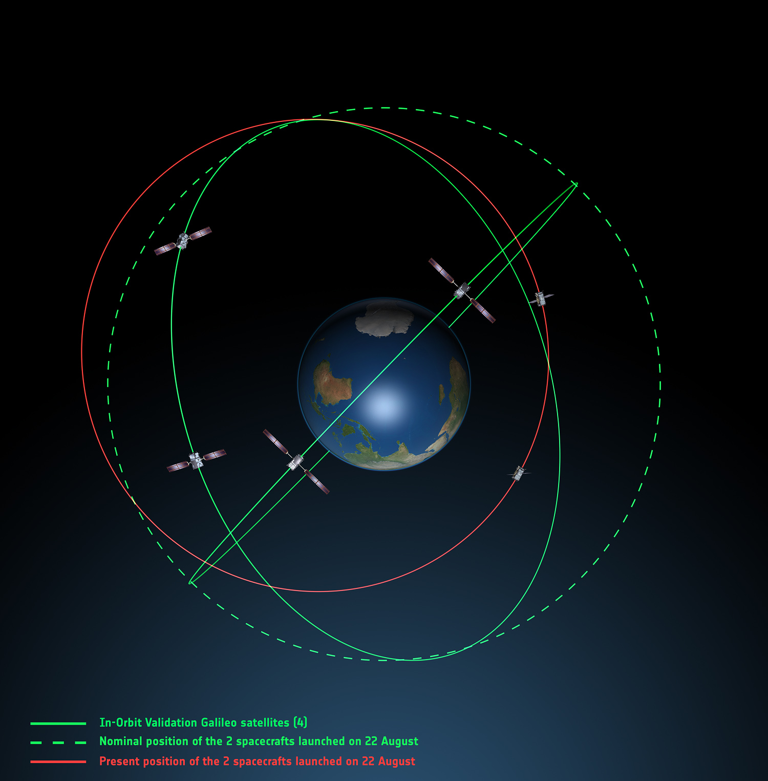
Galileo orbits viewed side-on: The fifth and sixth Galileo satellites in red, compared to their intended position in dashed green, and the position of the four satellites launched in 2011 and 2012, in solid green. This view looks side on to the two satellites’ orbital plane, which is off-center relative to Earth. The targeted orbit was circular, inclined at 55º to the equator at an altitude of 23,222 km.They are in a safe state, correctly pointing towards the Sun, properly powered and fully under control of an ESA–CNES team.
Soyuz at Fault? On August 28, the Russian newspaper Izvestia reported that “The failure of the European Union’s Galileo satellites to reach their intended orbital position was likely caused by software errors in the Fregat-MT rocket’s upper stage.”
“The nonstandard operation of the integrated management system was likely caused by an error in the embedded software. As a result, the upper stage received an incorrect flight assignment, and, operating in full accordance with the embedded software, it has delivered the units to the wrong destination,” an unnamed source from Russian space Agency Roscosmos was quoted as saying by the newspaper.
An independent inquiry panel has been set up by Ariane and headed by former ESA Inspector General Peter Dubock. It started work on August 28. The panel includes a couple of academics and a majority of ESA and EC figures.
The new EC commissioner in this area, Ferdinando Nelli Feroci, invited ESA and Arianespace to his study during the first week of September to present the initial results of the inquiry.
The commissioner commented, “The problem with the launch of the two Galileo satellites is very unfortunate. The European Commission will participate in an inquiry with ESA to understand the causes of the incident and to verify the extent to which the two satellites could be used for the Galileo programme. I remain convinced of the strategic importance of Galileo, and I am confident that the deployment of the constellation of satellites will continue as planned.”
The commissioner expects that the Galileo constellation will be fully deployed by the end of this decade. This may qualify as optimism because system planners had envisioned for six spares — and three are already blown.
Ariane and ESA did not insure the satellites.
According to back-of-the-envelope calculations, system operators are now one short of the minimum 24 needed for full 24/7 global coverage, as they have four in orbit validation satellites up (one broken) and 22 FOCs on order (two launched and now in what could be called a junk orbit), which makes a potential maximum 23 satellites that have actually been ordered — one short of the target.
The Satellites Are Alright. Satellite manufacturer OHB Systems of Bremen, Germany, issued a release stating that “Controllers at ESA’s ESOC control centre in Darmstadt, Germany, confirm the good health and the nominal behavior of both satellites. They are in a safe configuration, are thermally stable, have stable pointing to the sun and sufficient power production. All platform subsystems have been checked and they work properly. Also, the procedures to deploy the solar arrays are successfully performed and all solar arrays are properly unfolded.”
Further, “The orbit anomaly has no impact on the production and delivery of the in total further 20 satellites. Two FOC satellites are currently at ESTEC test facilities in Noordwijk, the remaining are in various status of integration. ”
Blogs Alive; BBQ Mode. The chairman of the Executive Board of the German Aerospace Center, Johann-Dietrich ‘Jan’ Wörner, writes an interesting blog. A recent installment opened with a quote from Elon Musk: “Rockets are tricky.”
Wörner went on to say, “The Soyuz launcher lifted off from the European Spaceport in French Guiana. Initially, all of the measurements suggested a perfect mission; the launcher took off at the scheduled time, followed the prescribed trajectory, and the stage separation was carried out correctly. However, the first problem became apparent when the two satellites proved unable to deploy their solar arrays as intended. A more detailed analysis then revealed that the eccentricity, the altitude and the inclination of the satellites’ orbits with respect to Earth’s equator did not meet the specifications. The upper stage had also evidently failed to induce the planned rotation around the longitudinal axis of the spacecraft (known as ‘barbeque’ mode, designed to maintain favourable thermal conditions during exposure to the Sun).”
Further discussion of the possible causes of the anomaly can be found on a Russian site, which focuses on the Fregat stage thrusters and indicates that the Russians think the barbeque maneuver was completed, and thus not the problem.
The other big issue is how the telemetry didn’t pick up the issue straight away.
The upcoming Telematics Munich conference, scheduled for November 10-11 at the Hotel Dolce Munich, is considered Europe’s largest and most influential business conference and exhibition for the connected car industry.
More than 1,000 industry executives and 100 speakers are set to attend the conference, which has the theme “The Car Plugs into the Connected World: Auto Mobility Strategies for 2020.”
This year’s agenda covers these topics:
Personalized Connectivity Prevails — Context is king as data from changing driving environments sync with personal preferences to create a UX that bridges generational gaps.
Data Investments Pay Out —Collect. Analyze. Deliver. Harness connected car data to obtain real consumer and vehicle insights and generate new revenues.
Move with the M2M Hype Curve —Align the tech of other connected industries (such as home automation and health) with the car to draw closer to a totally connected lifestyle.
Tech Titans Enter The Connected Car —Discuss the business model and CRM repercussions for entrenched telematics players as CE giants move into the ecosystem.
Auto Mobility Towards 2020 — Debate OEM commitments, V2X tech, and smart cities today to plot the path of automated vehicle technology of tomorrow.
The Jupiter SL869-V2S GPS module. Photo: Telit Wireless Solutions
Telit Wireless Solutions, a global provider of high-quality machine-to-machine (M2M) modules and services, today debuted the Jupiter SL869-V2S GPS module, designed for easy migration between a full-GNSS solution for top-ranked applications and a simple GPS-only solution for less demanding applications.
The Jupiter SL869 V2S supports GPS as well as QZSS constellations and is ROM based. Geo-location data is delivered using NMEA protocol through a standard UART port. It supports ephemeris file injection (A-GPS) as well as Satellite Based Augmentation System (SBAS) for increased position accuracy. Its onboard software engine is able to locally predict ephemeris three days in advance starting from ephemeris data broadcast by GNSS satellites, received by the module and stored in the host flash memory.
Key benefits include:
Pin-to-pin compatibility with JN3/xL869 family
Same protocol used in SL869 V2
Straightforward migration between full-GNSS solutions and GPS-only solutions
SBAS support, for increased position accuracy
Assisted GPS
The SL869 V2S can replace the JN3, SL869 or SL869 V2 — allowing customers to design once and interchangeably mount the appropriate solution depending on the required features. The xL869 is Telit’s GNSS unified form-factor family, which allows customers to select among different GNSS technologies and feature sets. Modules in this family are offered in a 16 x 12.2 mm, 24-pad, LCC package.
“The new SL869 V2S module is designed to be easily swapped with other xL869 modules for enhanced simplicity and scalability,” said Taneli Tuurnala, CEO of Telit GNSS Solutions. “It is an ideal example of how buying a module from Telit enables our customers to avert the need to keep track of the latest chipset technology on their own. We keep them on top of the best available technology, pre-packaged in a module that is easy to replace as needed, without having to redesign their entire application to stay up to date.”
Icaros Inc., a provider of advanced aerial remote sensing and 3D visualization solutions, will demonstrate the Icaros Measurement Tool (IMT) at the 2014 InterGeo Conference in Germany. Designed for use with oblique aerial imagery, IMT is a simple but powerful photogrammetric visualization application based on ArcGIS technologies, the company said.
To view a demonstration of the IMT, visit Icaros in stand #A4.009 Hall 4.1 at the InterGeo Conference and Trade Fair being held in Berlin on October 7-9.
The IMT is a universal oblique measurement tool. It enables customers working within Esri’s GIS environment to view and measure structures in oblique aerial imagery captured by any commercial oblique sensor system, including those from Pictometry, Vexcel/Microsoft, IGI, Leica, and Midas. IMT works equally well measuring images captured by oblique sensors mounted on unmanned aerial vehicles (UAV).
“Icaros is opening the oblique market to all GIS users by enabling them to purchase imagery from any of the growing number of aerial oblique data providers,” said Richard Baumgartner, vice president of Business Development at Icaros. “For too long, the purchase and use of oblique imagery have been limited by proprietary collection systems and metadata formats.”
Access to additional oblique vendors will reduce data costs in the long run, Icaros said. In addition, IMT lets users unlock the full potential of their imagery by combining 3D analysis capabilities with their GIS data. The tool is specifically designed to make highly accurate vertical and horizontal 3D measurements of structures and surfaces, including calculating distances, areas, slopes, and azimuths in complex 3D features.
Baumgartner explained that oblique imagery is already used extensively in tax assessment and public safety applications, but many other markets are waiting to be served by off-nadir image data. The Icaros vision is to expand the use, visualization and analysis of oblique aerial images into the entire spectrum of GIS markets. Oblique analysis of structures can be beneficial to a host of new applications such as facility management, pipeline corridor infrastructure monitoring, energy audits, economic development, and asset management.
“Asset and facility management are the next big applications for oblique imagery within the emerging 3D GIS market,” said Baumgartner.
As GIS users continue the move to 3D, oblique imagery will be critical for constructing accurate image-based realistic 3D models. IMT enables users to manipulate and view oblique imagery while leveraging other geospatial data layers within their GIS environment. This capability allows users to navigate multi-image scenes in three dimensions while zooming and panning.
The IMT software also provides an optional Icaros Digitizer Tool (IDT) for generating 3D models. “IDT provides additional tools to extract physical building structures and digitize them into open format models, such as Collada, Obj, and Ply, textured from the source imagery,” Baumgartner said. “Automated 3D model generation from oblique imagery is at the intersection between imagery and GIS.”
Andy Yin, ComNav Technology, Ltd., shares on the company’s K series GNSS OEM boards and receivers at the 2014 ION GNSS+ Conference September 9-12 in Tampa, Florida.
The Consumer Electronics Association (CEA) has announced that Boo-Keun Yoon, president and CEO of Samsung Electronics, will deliver the keynote address at the 2015 International Consumer Electronics Show. The International CES will take place in Las Vegas, January 6-9, and Yoon will talk at 6:30 p.m. January 5 in the Palazzo Ballroom at the Venetian.
Yoon will discuss connected devices, the future of the Internet of Things (IoT), and the vision of the smart home. He also will focus on Samsung’s vision of strategic partnerships that will drive the next wave of technology breakthroughs.
“Samsung is widely-known for its disruptive technologies and business models, and has been one of the fastest growing CE brands in the world,” said Gary Shapiro, president and CEO, CEA. “Samsung amazes at each CES with its innovative products spanning the entire tech ecosystem. We welcome Boo-Keun Yoon back to the keynote stage for the 2015 CES.”
Yoon began his career at Samsung Electronics in 1978. After serving in a number of leadership positions at Samsung Electronics, Yoon headed Samsung’s Visual Display Business from 2007, seeing its revenue double while maintaining the company’s No. 1 global TV market share for eight consecutive years. Currently, Boo-Keun Yoon serves as the president and CEO of Consumer Electronics at Samsung Electronics, leading Samsung’s Visual Display, Digital Appliances, Printing Solutions and Health & Medical Equipment Business. In addition, Yoon also acts as the company’s Chief Design Officer.
According to CEA/GfK research, global consumer technology spending will top more than $1 trillion in 2015. Lauded for its innovative design and technology across its diverse portfolio of products, Samsung Electronics is a leading global brand for high-tech electronics and digital media.
The 2015 CES will feature more than 3,500 exhibitors unveiling the latest consumer technology products and services across the entire ecosystem of consumer technologies. For more information on the 2015 CES, visit CESweb.org.
Handheld Group, a manufacturer of rugged mobile computers, has launched the Nautiz X8 rugged PDA. The Nautiz X8 is a handheld computer with superior processing power, screen performance and battery life, the company said. It is built for tough field conditions primarily in GIS, land surveying, public safety, forestry and the military.
The Nautiz X8 is built to enable efficient and reliable data collection in tough environments. It has an IP67 ingress protection rating, which means it offers complete protection against dust and sand and can withstand immersion in water. It also meets stringent MIL-STD-810G military test standards for overall durability and resistance to humidity, shock, vibration, drops, salt and extreme temperatures.
The Nautiz X8 features a high-performance Texas Instruments 4470 dual-core 1.5 GHz processor. It has 1 GB of RAM, 4 GB of iNAND Flash and a 5200 mAh Li-ion battery that lasts up to 12 hours on a single charge. It comes with a choice of operating systems — Android 4.2.2 or Windows Embedded Handheld 6.5.3.
The device has a large 4.7-inch ultra-bright capacitive multi-touch screen with chemically strengthened Asahi Dragontrail glass, offering users brightness and protection in any field condition. The unit has an ergonomic design and weighs 490 grams (17.3 ounces).
The Nautiz X8 has a dedicated u-blox GPS receiver, Bluetooth 2.0 and 802.11b/g/n WLAN functionality, as well as connectivity through GSM/UMTS or CDMA phone data transmission. A built-in 8-megapixel camera with autofocus and an LED flash lets users capture visual data quickly and easily. This handheld also features an open architecture and an extension cap system that allows for additional hardware connections such as sensors, radios and other add-ons.
Orders for the new Nautiz X8 can be placed immediately. First deliveries will begin in November.
The Nautiz X8 rugged handheld will be shown first at WEFTEC in New Orleans, followed by InterGeo in Berlin.
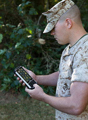
Handheld Group, a manufacturer of rugged mobile computers, has launched the Nautiz X8 rugged PDA. The Nautiz X8 is a handheld computer with superior processing power, screen performance and battery life, the company said. It is built for tough field conditions primarily in GIS, land surveying, public safety, forestry and the military.
Photo: Handheld Group
The Nautiz X8 is built to enable efficient and reliable data collection in tough environments. It has an IP67 ingress protection rating, which means it offers complete protection against dust and sand and can withstand immersion in water. It also meets stringent MIL-STD-810G military test standards for overall durability and resistance to humidity, shock, vibration, drops, salt and extreme temperatures.
The Nautiz X8 features a high-performance Texas Instruments 4470 dual-core 1.5 GHz processor. It has 1 GB of RAM, 4 GB of iNAND Flash and a 5200 mAh Li-ion battery that lasts up to 12 hours on a single charge. It comes with a choice of operating systems — Android 4.2.2 or Windows Embedded Handheld 6.5.3.
The device has a large 4.7-inch ultra-bright capacitive multi-touch screen with chemically strengthened Asahi Dragontrail glass, offering users brightness and protection in any field condition. The unit has an ergonomic design and weighs 490 grams (17.3 ounces).
The Nautiz X8 has a dedicated u-blox GPS receiver, Bluetooth 2.0 and 802.11b/g/n WLAN functionality, as well as connectivity through GSM/UMTS or CDMA phone data transmission. A built-in 8-megapixel camera with autofocus and an LED flash lets users capture visual data quickly and easily. This handheld also features an open architecture and an extension cap system that allows for additional hardware connections such as sensors, radios and other add-ons.
Orders for the new Nautiz X8 can be placed immediately. First deliveries will begin in November.
The Nautiz X8 rugged handheld will be shown first at WEFTEC in New Orleans, followed by InterGeo in Berlin.
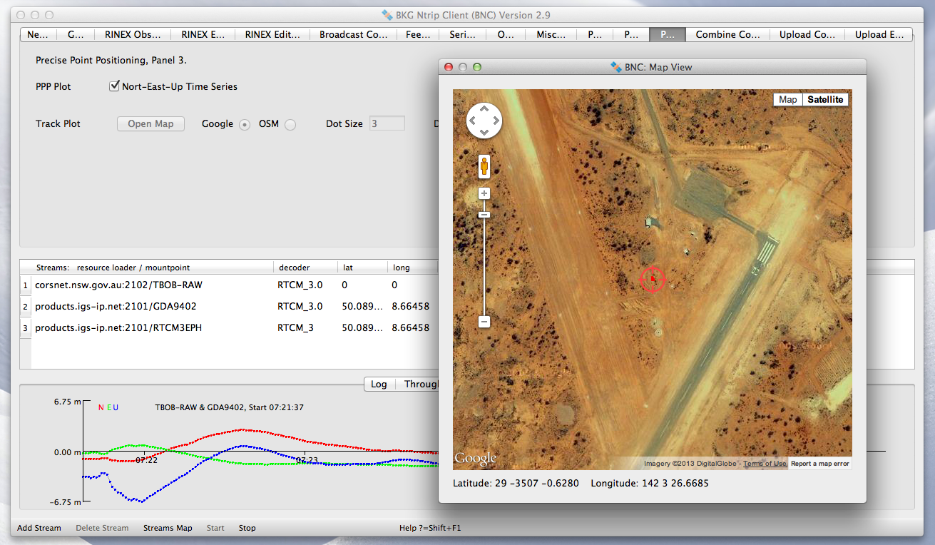
The International GNSS Service (IGS) has published a new version of the Open Source BKG NTRIP Client (BNC) for real-time GNSS applications and RINEX3 QC.
Follow this IGS link to download precompiled binaries for Linux and Windows systems. Version 2.11.0 includes a bug fix for GLONASS code biases as well as RTCM SSR message updates for PPP. The maximum number of GNSS observations has been increased and the loss of lock handling modified. Also, BNC now supports raw stream output through TCP/IP port.
The source code is available via SVN software archive. A Mac binary is under preparation.