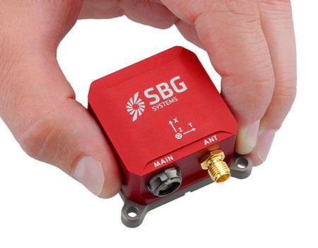
SG Systems’ IG-500 Series of miniature inertial sensors. Photo: SBG Systems
SBG Systems has released the Ellipse Series, a product range of miniature inertial systems replacing the IG-500 Series. For the same budget, customers benefit from higher accuracy, advanced filtering and features of high-end inertial navigation systems, the company said.
The Ellipse Series of miniature inertial systems benefits from a new design, new sensors, new capabilities, and new algorithms. “We have selected state-of-the-art MEMS sensors, especially very low noise gyroscopes that greatly enhance Ellipse performance. We integrated cutting-edge GNSS receiver while keeping a small size,” said Alexis Guinamard, CTO of SBG Systems.
“We are able to upgrade miniature sensors capabilities by injecting some advanced and proven filtering and features inspired from high end inertial navigation systems,” Guinamard said. Besides higher accuracy, SBG Systems added for the same budget an improved FIR and rejection filtering, robust IP68 enclosure, high output rate, RTK corrections, and automatic alignment.
Weighting from 45 grams, Ellipse sensors are flexible. The Ellipse-A model provides 3D orientation and heave. For navigation, users can connect their own GPS receiver with the Ellipse-E, or use an internal receiver by choosing the Ellipse-N model. The larger Ellipse-D integrates a survey-grade L1/L2 GNSS receiver with two antennas for heading and position accuracy.
Ellipse A, N, E models are available for order now. The Ellipse-D model will be available in the first quarter of 2015.
LizardTech, a provider of software solutions for managing and distributing geospatial content, has launched GeoGofer, a new addition to its product line. GeoGofer is a software solution for finding geospatial imagery quickly and efficiently, regardless of where it is located.
GeoGofer was designed to streamline the process of finding, organizing, and tracking geospatial imagery. To that end, GeoGofer comes with powerful search and filter features that can be used to find imagery by keyword, by projection, by file format and more.
“Our customers will never again have to struggle to find their geospatial images,” said Jon Skiffington, director of product management at LizardTech. “Our product preview demonstrations have received overwhelmingly positive feedback from existing LizardTech customers and from a sampling of Esri User Conference attendees.”
With GeoGofer, users can browse all of their imagery on a single map, tag images for later use, and perform powerful queries using simple tools. Users can search by modification date, by number of bands, or by resolution to find the imagery they need.
GeoGofer integrates fully with trusted Esri technology. GeoGofer uses an existing ArcGIS Online subscription to store and query image information. Additionally, if users have ArcMap installed on the same machine that runs GeoGofer, they can open images directly in ArcMap.
More product information, purchase options, and a free 14-day trial are available at the website.
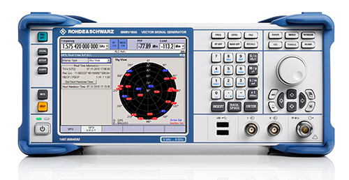
Rohde & Schwarz will be demonstrating its SMBV100A simulator at ION GNSS+ 2014, and is offering a new Wireless Standards poster for visitors to its booth. Rohde & Schwarz will be exhibiting in Booth I during the show, which will be held in Tampa, Florida, September 10-11.
Based on a digital vector signal generator, the SMBV100A supports realtime and hybrid configurations up to 24 dynamic GPS, GLONAS, Galileo, BeiDou and QZSS satellites and can be synchronized for multi-channel RF solutions. Rohde & Schwarz will be demonstrating its latest SMBV100A solutions and technologies along with dedicated solutions to support navigation and GNSS testing including:
Support realistic user environments: obscuration, multipath, antenna characteristics and vehicle attitude
Realtime external trajectory feed for hardware in the loop (HIL) applications
High signal dynamics, simulation of spinning vehicles and precision code (P code) simulations
Support for ground-based augmentation systems (GBAS)
Avionics test solutions: VOR, ILS, DME, and TACAN
Field-to-lab capture and playback solutions
Interference hunting and direction finding solutions
New Wireless Standards Poster – Register Now!
Conference attendees who stop by Booth I can register for a new Wireless Standards Poster. The convenient wall chart provides an overview of all the major standards for digital cellular, public safety, TV white space, wireless connectivity and GNSS technologies.
Not able to attend? Click here to register to have a poster sent to you.
The year 2014 is most certainly the Year of Galileo.
After rising up from near elimination in 2008 due to much confusion about how to fund it, the European Union, that same year, decided to allocate 3.4 billion euros to fund the ground infrastructure and the initial satellites. Unlike the U.S. GPS and Russian GLONASS systems, Galileo is civilian-funded as opposed to being funded primarily from defense budgets, which makes it politically much more difficult to gain funding. But, they did it.
That was six years ago.
Since then, ground infrastructure has been designed and built. Six test satellites have been designed, built and successfully launched into orbit. In early 2013, the first position fix using only Galileo satellites was achieved. With all the necessary test satellites launched and systems tested, the anticipation of FOC (Full Operational Capability) satellite launches has been high, because it would signal the rapid deployment of the Galileo navigation system that would so complement GPS and so benefit the high-precision GNSS user community.
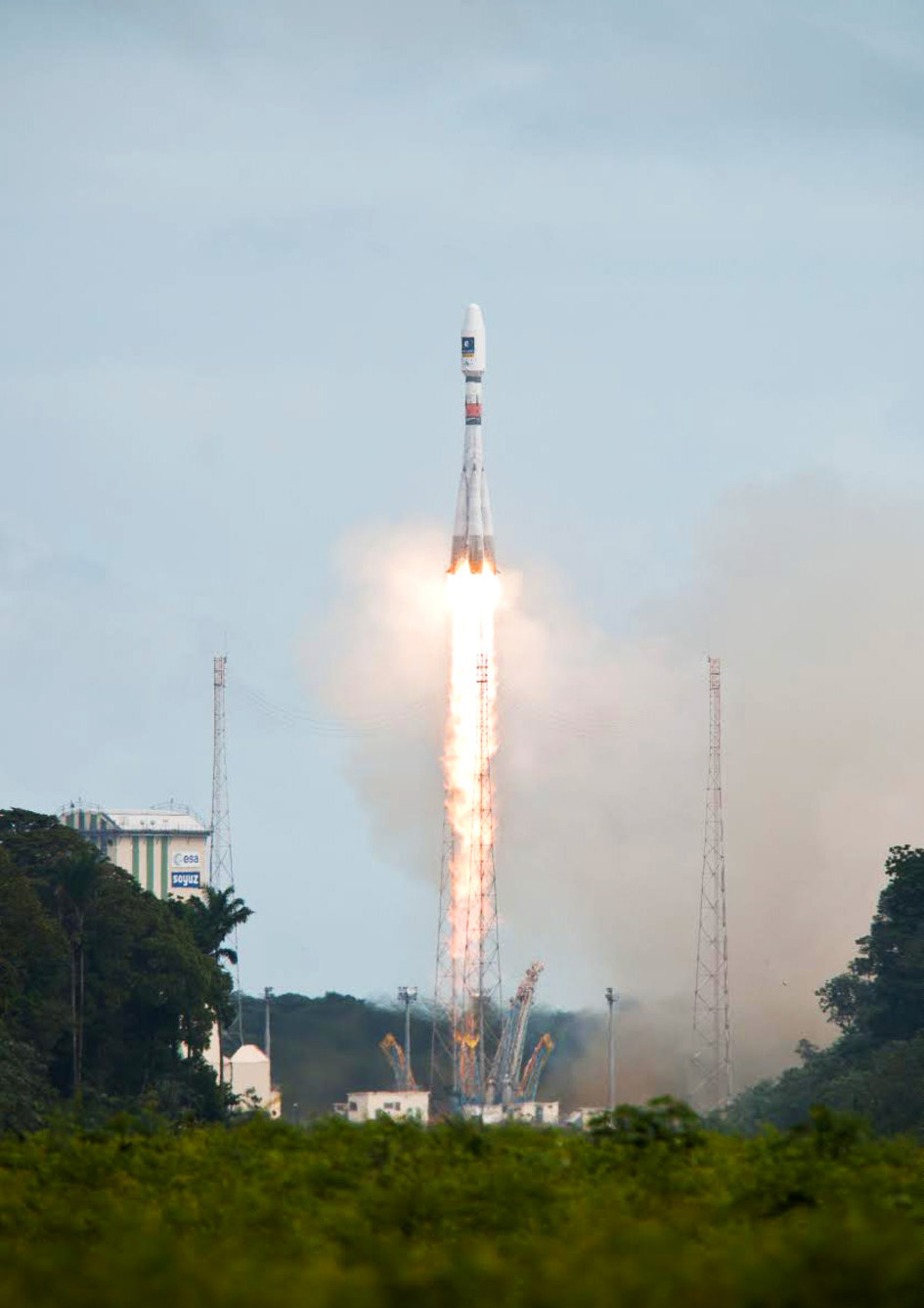
Soyuz Flight VS09, carrying Europe’s fifth and sixth Galileo satellites, lifts off from Europe’s Spaceport in Kourou, French Guiana.
That moment arrived last month, on August 22, with the launch of the first two Galileo FOC satellites. The significance of the first FOC launch is that it would trigger an aggressive launch schedule comprised of one launch every three months, at two satellites per launch — equaling eight satellites launched per year. With four test satellites already in orbit being converted to operational satellites, one can envision 16 Galileo satellites in orbit by the end of next year. While not a complete constellation at that point, it would offer plenty of upside — worldwide I might add, as I’ve written about in the past — by adding more satellites in view and accelerating the adoption of the new L5 signal, which is also supported by GPS.
Between Europe deploying Galileo and China deploying its BDS (BeiDou) system, the world of high-precision GNSS is going to change a lot in the next couple of years. There will be more receiver choices at much lower prices for RTK receivers.
But, the satellite navigation business is not a forgiving one. The devil is in the details, and the number of details has got to be overwhelming. Consequently, there have been many casualties.
The Russians have taken their lumps, losing a total of seven GLONASS satellites to faulty rocket launches in just the past four years.
In 2009, the U.S. placed into orbit a GPS satellite, SVN-49, that never has been set healthy, rendering it a “$100M test satellite.”
Now, the Europeans have joined the club.
The “pucker factor” during the satellite launches is always high, so on August 22, when two Galileo satellites mounted on a Russian Soyuz rocket at the Arianespace launch pad in French Guiana were pushed up into space, there must have been a sigh of relief that the launch seemed to go smoothly. Even I was excited, Tweeting “#Galileo Launch Successful, Satellites Deployed. Booyah!”, shortly after the launch.
However, looks can be deceiving.
It turns out that somehow, some way, the two Galileo satellites, after years of planning, were inserted into the wrong orbits.
The liftoff and first part of the mission proceeded nominally, reports Arianespace, leading to release of the satellites according to the planned timetable, and reception of signals from the satellites. However, the targeted orbit was circular, inclined at 55 degrees with a semi major axis of 29,900 kilometers. The satellites are now in an elliptical orbit, with excentricity of 0.23, a semi major axis of 26,200 km and inclined at 49.8 degrees.
With navigation satellites, we’ve seen disastrous launch failures and defective satellites placed in orbit, but I can’t recall ever hearing about navigation satellites being inserted into the wrong orbits. It’s difficult not wonder how such a seemingly simple error could occur, yet sympathize with the Galileo program managers given the complexity of the task, but also appreciate the consistency and reliability of GPS satellite deployments.
Galileo satellites fastened to upper stage.
The Russians quickly commented on the satellite deployment anomaly since it was a Russian Soyuz rocket launcher, speculating that it was a software bug. The Russian newspaper Izvestia quoted an unnamed source from the Russian Space Agency Roscosmos that “the failure of the European Union’s Galileo satellites to reach their intended orbital position was likely caused by software errors in the Fregat-MT rocket’s upper stage.”
It’s too early to say if the Galileo satellites will ever become serviceable. The Monday following the launch, an independent inquiry commission was formed to “establish the circumstances of the anomaly, to identify the root causes and associated aggravating factors, and make recommendations to correct the identified defect and to allow for a safe return to flight for all Soyuz launches from the Guiana Space Center (CSG).”
This subject will certainly be a hot topic at the Institute of Navigation (ION) GNSS conference being held next week in Tampa, Florida. A full staff of GPS World editors and administration folks will be attending, including yours truly. It’s the premiere GNSS technical event of the year, so I’m sure there will be plenty of scientists and program managers commenting and speculating on the future of these two satellites.
If you’d like the latest news on this and other GNSS-related subjects during the conference next week, follow me on Twitter at https://twitter.com/GPSGIS_Eric. There are lots of interesting subjects at the ION GNSS+ conference. Take a look at the conference agenda here. I’ll be attending many of the presentations related to high-precision GNSS and report to you in next month’s newsletter. To give you a flavor, following are some of the presentations that I’m going to try to attend.
The Triple-frequency Multi-system RTK Engine for Challenging Environments
Mobile Mapping Using Smartphone
Analysis of Using Smartphones for Indoor Mobile Mapping
GPS Program update
Galileo Program Update
Glonass Program update
BDS Program update
GLONASS Only and BeiDou Only RTK Positioning
Comparing Multi-constellation and Multi-frequency Based on GPS/Beidou RTK Positioning
Combined GPS+BDS+Galileo+QZSS for long single-baseline RTK positioning
Real-time PPP with Galileo, Paving the Way to European High Accuracy Positioning
High-Precision GNSS — What will it Look Like in 2020?
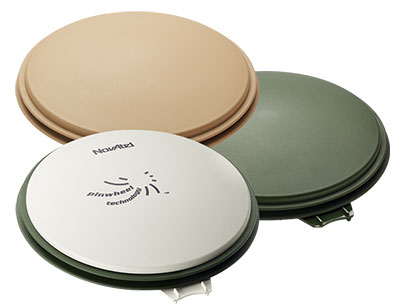
The NovAtel GPS-702-GG-HV high-performance pinwheel antenna comes in three colors. Photo: NovAtel, Inc.
NovAtel, Inc., has introduced the GPS-702-GG-HV to its line of high-performance Pinwheel antennas. Tracking L1/L2 GPS and L1/L2 GLONASS frequencies, customers can use the same antenna for GPS-only or dual constellation applications, reducing equipment costs and need for future redesign, the company said.
With the same form-factor and choke ring performance as the company’s other pinwheel antennas, the GPS-702-GG-HV has been enhanced even further to provide the robustness needed for use under high-vibration conditions.
The phase center of the antenna remains constant as the azimuth and elevation angle of the satellites change. Signal reception is unaffected by the rotation of the antenna or satellite elevation, so placement and installation of the antenna can be completed with ease. With the phase center in the same location for both the L1 and L2 signals and with minimal phase center variation between antennas, this antenna is designed for baselines of any length.
Enclosed in a durable, waterproof housing, the GPS-702-GG-HV comes in three colors: NovAtel standard grey, as well as desert tan and olive drab for military customers. The antenna is available for order beginning September 12.
An Indian high-tech start-up is offering a GPS-enabled smart sports shoe that vibrates to give the wearer directions, according to an article in gulfnews.com.
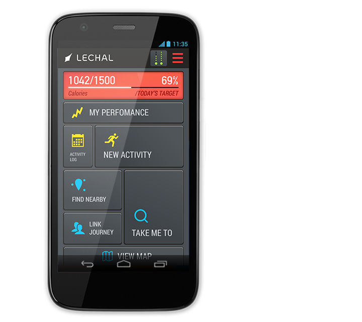
The red sneakers count the number of steps taken, the distance traveled, and calories burned. The shoes go on sale this month under the name LeChal, which means “take me along” in Hindi.
The shoes come with a detachable Bluetooth transceiver that links to a Lechal smartphone app to direct the wearer using Google Maps, sending a vibrating signal to indicate a left or right turn.
They are the brainchild of 30-year-old Krispian Lawrence and Anirudh Sharma, 28, two engineers who founded their tech start-up Ducere in a small apartment in 2011 and now employ 50 people. They say they have 25,000 advance orders for the shoes, which will retail at between $100 and $150.
The Lechal app works with Google Maps. Photo: Lechal
AT&T will be a major participant during CTIA’s Super Mobility Week in Las Vegas next week. Connected car, connected home and wearables will all be on display throughout AT&T’s activities:
The first AT&T Hackathon to take place at CTIA will give developers access to new APIs for the car and home.
A 60-foot x 40-foot booth showcasing the latest Connected Life products.
AT&T is kicking off the week’s events with its very first CTIA Hackathon, Code for Car and the Home, which will match developers with companies, tools and services to innovate in the connected car and automated home marketplace. Developers will turn ideas into apps using APIs and other technology resources from 30-plus industry sponsors. More than 300 developers are expected to compete in the two-day Hackathon which begins at 10 a.m. PT on Saturday, September 6, in the Chelsea Theater at the Cosmopolitan Hotel. More than $100,000 in cash and prizes are available.
Connected Life Booth
When the Super Mobility Week show floor opens at 11 a.m. PT on Tuesday, September 9, AT&T will showcase the latest in wearables, connected cars and homes. Volvo and Audi will demo their connected car experiences and a simulator will be on-site to showcase AT&T Drive, the company’s connected car platform. AT&T Drive is a modular, global solution that allows automakers to pick and choose what services and capabilities are important to them in order to differentiate their solutions in the marketplace.
Attendees can also explore how to stay connected to the home by visiting the AT&T Digital Life station. Digital Life is an all-digital, all-wireless automation and home security platform that equips customers with control of their homes from virtually anywhere. On-site activations will include demos such as augmented reality so visitors can learn about the Digital Life service and products, an interactive wall to experience the simple, easy to use Digital Life app and a hologram home to showcase how Digital Life integrates everything you need in one place, to help make your life safer and easier, and provide you with more freedom to live your life.
AT&T is the leader in emerging devices and will showcase the latest wearables from Fitbit, Jawbone, LG, Martian and Pebble. Additionally, Timex, the first authentic watch brand to enter the smartwatch space, will be on-site showcasing the new Timex Ironman One GPS+. The new smartwatch is the first GPS-connected fitness watch to connect to the mobile internet wirelessly, transmitting performance data, location, messages and more.
Also on display will be the AT&T EverThere and FiLIP safety devices. AT&T EverThere is a small wearable device that can detect falls and quickly identify location, automatically connecting the user to a 24/7 call center for response and support. FiLIP is a smart locater for kids that keeps parents and kids in touch at the push of a button.
The booth, number 4423, will be in the Connected Life section of the show floor at the Sands Expo and Convention Center. Visitors can locate the booth by using the interactive floor plan.
Connected Car Keynote
On Wednesday, Sept.10, Ralph de la Vega, president and CEO, AT&T Mobile and Business Solutions and Glenn Lurie, president and CEO, AT&T Mobility, will wrap up the show when they take the stage to discuss the Future of Connected Car.
The following guest panelists will join them on stage to discuss this rapidly growing landscape:
Mary Chan, President, Global Connected Consumer, General Motors
Arun Bhikshesvaran, CMO, Ericsson
Mike Kennewick, Co-Founder and CEO, VoiceBox
Diarmuid O’Connell, VP, Business Development, Tesla Motors
CartoPac International Inc. has announced a major new release of the CartoPac Mobile Platform. CartoPac 5.0 extends the mobile platform with support for Windows 8 and introduces the CartoPac Workflow Manager, which provides a structured process to manage the use of geospatial data across the enterprise.
CartoPac will demonstrate the applications and technologies of Version 5.0 in the free CartoPac Mobility Webinar Series beginning on September 30.
The CartoPac Platform is a configurable suite of field and office tools designed to maximize the productivity of crews as they digitally map, inventory and inspect critical assets using GPS-enabled mobile devices. Seamlessly integrating with the Esri ArcGIS Server, CartoPac is used extensively by oil and gas companies, pipeline operators, electric utilities, state/local governments and environmental engineering firms to populate the enterprise GIS and asset-management systems with captured infrastructure information.
The new CartoPac Workflow Manager (CWM) in CartoPac 5.0 provides organizations with a structured workflow to view, edit, validate and approve asset data as it moves from the field back into the enterprise. CWM ensures that individuals responsible for data are notified as it comes into the organization so they can incorporate the data into systems related to work-order fulfillment, risk analysis, integrity modeling and other asset management processes.
CartoPac developed CWM for the management of heavily regulated assets in the field, such as gas pipelines and electric distribution infrastructure. A module within the CartoPac Server, the CWM extension creates an audit trail of all the edits and modifications made to the data sets that represent the monitoring and maintenance of real world assets in the field.
“CartoPac Workflow Manager fills the gap between data collection and enterprise asset management systems to enable organizations to maximize the value of their data,” said CartoPac CIO Scott Crouch. “CWM enables organizations to show regulators they have a structured process for tracking and responding to the conditions of their critical assets and has proven to be key component for assisting companies with their regulatory compliance and integrity management programs.”
Further expanding the capabilities of the CartoPac mobile components, version 5.0 has been optimized for the Windows 8 operating system running on standard GPS-enabled laptop computers and tablet devices. This migration means that crews can use CartoPac to collect and manage asset data in the field on the same hardware devices they will use back in the office to run their daily business applications.
“The attractive cost, integration with GPS and expanded performance of Windows 8 tablets and laptops will enable organizations to put more personnel into the field, ensuring that vital infrastructure is mapped, inventoried and properly managed,” said Crouch “Laptop/tablet-equipped maintenance personnel in the field will now be able to run CartoPac solutions on the hardware they already use for tracking repairs and closing work orders.”
To demonstrate the advantages of enterprise asset management, CartoPac has launched the CartoPac Mobility Webinar Series, which will feature applications by electric and gas utilities and highlight new mobile technologies. The first webinar, “Applying New Mobile Technologies to Electric Utility Inspections,” will be presented with EDM International Inc., a Colorado electric utility services company.
The free “Applying New Mobile Technologies to Electric Utility Inspections” webinar will be held on September 30, 2014, at 4:00 pm Eastern Time. To register, click here.
CartoPac International Inc. has announced a major new release of the CartoPac Mobile Platform. CartoPac 5.0 extends the mobile platform with support for Windows 8 and introduces the CartoPac Workflow Manager, which provides a structured process to manage the use of geospatial data across the enterprise.
CartoPac will demonstrate the applications and technologies of Version 5.0 in the free CartoPac Mobility Webinar Series beginning on September 30.
The CartoPac Platform is a configurable suite of field and office tools designed to maximize the productivity of crews as they digitally map, inventory and inspect critical assets using GPS-enabled mobile devices. Seamlessly integrating with the Esri ArcGIS Server, CartoPac is used extensively by oil and gas companies, pipeline operators, electric utilities, state/local governments and environmental engineering firms to populate the enterprise GIS and asset-management systems with captured infrastructure information.
The new CartoPac Workflow Manager (CWM) in CartoPac 5.0 provides organizations with a structured workflow to view, edit, validate and approve asset data as it moves from the field back into the enterprise. CWM ensures that individuals responsible for data are notified as it comes into the organization so they can incorporate the data into systems related to work-order fulfillment, risk analysis, integrity modeling and other asset management processes.
CartoPac developed CWM for the management of heavily regulated assets in the field, such as gas pipelines and electric distribution infrastructure. A module within the CartoPac Server, the CWM extension creates an audit trail of all the edits and modifications made to the data sets that represent the monitoring and maintenance of real world assets in the field.
“CartoPac Workflow Manager fills the gap between data collection and enterprise asset management systems to enable organizations to maximize the value of their data,” said CartoPac CIO Scott Crouch. “CWM enables organizations to show regulators they have a structured process for tracking and responding to the conditions of their critical assets and has proven to be key component for assisting companies with their regulatory compliance and integrity management programs.”
Further expanding the capabilities of the CartoPac mobile components, version 5.0 has been optimized for the Windows 8 operating system running on standard GPS-enabled laptop computers and tablet devices. This migration means that crews can use CartoPac to collect and manage asset data in the field on the same hardware devices they will use back in the office to run their daily business applications.
“The attractive cost, integration with GPS and expanded performance of Windows 8 tablets and laptops will enable organizations to put more personnel into the field, ensuring that vital infrastructure is mapped, inventoried and properly managed,” said Crouch “Laptop/tablet-equipped maintenance personnel in the field will now be able to run CartoPac solutions on the hardware they already use for tracking repairs and closing work orders.”
To demonstrate the advantages of enterprise asset management, CartoPac has launched the CartoPac Mobility Webinar Series, which will feature applications by electric and gas utilities and highlight new mobile technologies. The first webinar, “Applying New Mobile Technologies to Electric Utility Inspections,” will be presented with EDM International Inc., a Colorado electric utility services company.
The free “Applying New Mobile Technologies to Electric Utility Inspections” webinar will be held on September 30, 2014, at 4:00 pm Eastern Time. To register, click here.
u-blox has announced theODIN-W160, a rugged multiradio module for demanding industrial, vehicle, medical, and security applications.
“u-blox’ compact ODIN-W160 module is perfect for small sensor applications in rugged environments, where faultless operation 24/7 is a requirement,” says Herbert Blaser, vice president of short-range radio at u-blox. “With this module, u‑blox customers can shorten their product development cycle significantly by integrating a robust, certified communication solution in their IoT applications.”
ODIN-W160 supports dual-band Wi-Fi 2.4/5GHz (U-NII bands 1, 2, 2e, 3), as well as dual-mode Bluetooth v4.0, which includes Bluetooth low-energy and classic Bluetooth (Bluetooth “Smart Ready”).
The host-based module is designed for a long life cycle, which makes it ideal for infrastructure, building, and automotive implementations. In addition, it extends battery life operation due to its ultra-low power consumption.
Together with the open-source Linux host driver, the 15 x 22 x 3 mm module minimizes development time to implement short range wireless communications in end-devices. Also, no trimming or tuning is required during manufacturing of customer end-devices, since ODIN-W160 has pre-calibrated radio parameters and MAC address stored in on-board EEPROM.
ODIN-W160 is in a castellated package, improving visual inspection of end-devices, and comes with a u.fl antenna connector for a wide selection of certified antennas.
It provides modular radio type approvals for Europe, USA, and Canada (R&TTE, FCC, IC), EMC certification, and Bluetooth qualification.
u-blox will be atCTIA 2014 / Super Mobility Weekin Las Vegas September 9-11, at Stand 5229, 7611-A. u-blox will also be speaking about solutions for the Internet of Things on September 9, 12.00–12.15 at the Sands Expo — MobileCON Show Floor, stage 3.
On August 29, OmniEarth completed its acquisition of IRISmaps, Inc., in a stock-for-stock transaction. IRIS provides customized, cloud-based solutions that integrate Earth imagery with geospatial and business data to enable organizations to access information, analyze it, and take action to solve business problems quickly and effectively. The combined companies will be led by OmniEarth CEO, Lars Dyrud.
“We’re very excited about bringing IRIS into our team. The capabilities they bring will enable OmniEarth to deliver our value-added data stream to subscribers as soon as our constellation goes live,” Dyrud said. “IRIS also brings a portfolio of off-the-shelf products that provide the customer focused analytics platform that is crucial for turning data into insight.”
IRIS’ portfolio includes asset and environmental monitoring products that have been deployed at major agriculture and energy companies, and in the public sector. Dyrud sees this as a natural fit for OmniEarth, which is focusing its initial business offerings on underserved markets like agriculture and energy.
With the IRIS acquisition, OmniEarth will be well-positioned to deliver solutions that will inform all phases of energy exploration and development, Dyrud said. Specifically, the company plans to continue IRIS’ energy portfolio products, such as high-consequence area monitoring and thermal steam cycle analysis, as well as establish new ones that combine the talents of the IRIS software developers with rich data fusion and analytics enabled by the planned OmniEarth constellation.
Abstract submissions are now being accepted for The Institute of Navigation’s (ION) Pacific PNT Conference, to be held April 20-23, 2015, at the Waikiki Beach Marriott, Honolulu, Hawaii. Abstracts are due November 14, 2014.
Pacific PNT, where “East Meets West in the Global Cooperative Development of Positioning, Navigation and Timing Technology,” brings together policy and technical leaders from Japan, Singapore, China, South Korea, Australia, the United States, and more for policy updates, program status and technical exchange.
“Global cooperative interoperability” will frame the technical program. Leaders representing academia, government, industry and the scientific community will convene to solve PNT challenges that impact Pacific Rim development.
Pacific PNT 2015 is organized by a Pacific Rim advisory board and will feature technical papers presented on a diverse array of topics including:
Aircraft Navigation and Surveillance
Agricultural, Construction and Mining
Algorithms and Methods
Alternative Navigation and Signals of Opportunity
Aviation Applications of GNSS
Challenging Navigation Problems
Collaborative Navigation Topics
Earthquake & Tsunami Prediction and Monitoring with GNSS
GNSS Augmentations
GNSS Correction and Monitoring Networks
GNSS Environmental Monitoring
GNSS Policy/Status Updates
GNSS Signal Structures
Inertial Navigation Technology and Applications
Interference and Spectrum
Ionosphere Monitoring with GNSS
Magnetic Field Navigation and Mapping
Maritime Navigation
Nature-Inspired Navigation
PNT and Automobile Safety
PNT and Social Media
PNT for Domestic and Healthcare Applications
Precision Agriculture and Machine Control
Time and Frequency Distribution
UAS Technologies
Abstracts are being accepted through November 14, 2014. For more information the ION’s Pacific PNT 2015, visit www.ion.org/pnt.
PTTI 2014 Registration Opens
Registration is now open for the ION Precise Time & Time Interval Meeting (PTTI) 2014 to be held December 1-4 at the Seaport Boston Hotel, Boston, Massachusetts. The technical program is available online.
The annual PTTI conference has a technical program designed to disseminate and coordinate PTTI information at the user level; review present and future PTTI requirements; inform government and industry engineers, technicians, and managers of precise time and frequency technology and its problems; and provide an opportunity for an active exchange of new technology associated with PTTI.
The Distinguished PTTI Service Award, which recognizes outstanding contributions related to the management of PTTI systems, will be presented on Thursday, December 4.