The Trimble InSphere Data Manager provides efficient geospatial data management for an entire organization.
Trimble has introduced a new Data Marketplace service for the Trimble InSphere geospatial information management platform. The InSphere Data Marketplace allows geospatial professionals to quickly search, locate and obtain spatial data on demand. InSphere users can now find and use additional free and premium spatial data layers, including aerial and satellite imagery, terrain, elevation and topographic maps, building footprints and other third-party data. In addition, new capabilities have been added to a variety of InSphere applications to streamline geospatial data access.
“As the latest addition to the InSphere platform of applications, the Data Marketplace service plays an important role in our cloud-based geospatial information management platform. InSphere’s Data Marketplace is designed to help our customers find, manage and use spatial data critical to their business,” said Alain Samaha, business area director of software for Trimble’s Geospatial Division. “Giving our customers access to multiple layers of spatial information makes end deliverables more robust for their clients.”
The Trimble InSphere Data Marketplace is a new application that is part of Trimble InSphere, a cloud-based platform of software, data, and services focused on the needs of geospatial professionals including surveyors, engineers and GIS professionals. InSphere’s web interface provides access to other productivity-enhancing applications such as Trimble InSphere Data Manager, Trimble InSphere Equipment Manager, Trimble TerraFlex and Trimble Access Services.
The latest release also adds capabilities and enhancements to the applications within the InSphere platform:
Trimble TerraFlex — Unified Geospatial Data Collection and Simplified Digital Forms
The TerraFlex application includes productivity enhancement features that enable a tighter integration for Esri’s ArcMap plugin and allow GIS users to bring in data directly from TerraFlex into an ArcMap project. The module includes Esri basemap support for access to a range of freely available Esri basemap layers, new export options for more flexibility for portable data formats, exchange, and full Windows 7 and 8 support on TerraFlex Mobile. This enables users a broader range of devices to select and use in the field for collecting asset information data. In addition, the TerraFlex user interface is now integrated into the Trimble InSphere platform, giving users a seamless experience between TerraFlex and other InSphere modules. A 30-day free trial is available online.
InSphere Data Manager — Geospatial Information in One Place
Data Manager now supports Trimble Business center version 3.2 files, increasing support for more data file formats that a user is able to upload and view within the module. A 90-day free trial is available online.
The release expands the compatibility to add and manage more devices faster and easier. Users can now import a list of devices from an Excel spreadsheet to immediately begin managing devices in the module. In addition, Equipment Manager now supports Trimble Access Software version 2013.40 (and higher), increasing the number of devices that a user can manage. A 90-day free trial is available online.
The chief of Russia’s space agency Roscosmos has discussed plans for bilateral cooperation in space with his Chinese counterparts in Beijing, according to the ITAR-TASS news agency.
“On Thursday, the chief of Roscosmos held a meeting with the head of China’s Satellite Navigation Office Ran Chengqi. The officials discussed Russian-Chinese cooperation on navigation satellite systems GLONASS and Beidou, in particular, the placement of Russian stations in China and Chinese stations in Russia,” the Roscosmos press service said.
The two sides agreed to establish a sub-commission for cooperation in the sphere of satellite navigation under the bilateral commission in charge of preparing regular meetings of the two countries’ prime ministers.
Earlier, Roscosmos deputy chief Sergei Savelyev said that Moscow this year would sign an agreement with Beijing on deploying GLONASS and Beidou stations in China and Russia respectively. Each country will accommodate three such facilities.
Scientists and engineers of the GNSS persuasion will want to test their knowledge of the two-body model and Keplerian orbits in a practical application at the roulette wheel in GPS World’s booth, #224–#226, at the ION GNSS+ Conference.
Those successful in their predictions of the fall of the ball will mathematically increase their chances of winning a Go-Pro Hero video camera, a pair of tickets to the fabulous Leadership Dinner, or a bevy of $50 gift cards.
Simply fill out a subscription form and receive five chips for play at the roulette table. Bet odd or even, red or black; bet your favorite number or take a split. If the ball falls into the 0, 00, or 25 slots, all bets on the table, winning or losing, are paid off with a handsome additional stake! This is the magazine’s way of celebrating its 25th anniversary.
The more you win, the more raffle tickets you can put into the drawing bowl for the prizes. The prize drawing will be held during the afternoon break on Thursday, at approximately 3:40.
According to a well-known GNSS expert and ION attendee, “From the point of view of satellite orbital mechanics, the high-speed spinning of a ball within the outer rim of a roulette wheel resembles the orbit of a satellite around a massive body. Friction between the wheel and the ball generates orbital decay that causes the ball to lose speed and, once a certain loss of energy occurs, fall from the rim into the center of the wheel. In the case of roulette, timing the period of motion of both the ball traveling around the rim and the wheel in the center combined with an orbital decay model allows a computer to predict the correct quandrant of the wheel that the ball will settle into as much as 40 percent of the time. Properly implemented, this is enough to create a tremendous advantage over the casino.”
You too can turn your scientific knowledge to lucrative advantage!
GPS World Booth #224–#226 is located at the rear of the hall, adjacent to the attendee lounge. The roulette wheel will be in operation during all exhibit floor hours, including the Wednesday evening reception.
This is the mecca of geographic information systems, or GIS, at least in the United States: the 2014 Esri International User Conference (UC) in San Diego, California, held every July. GPS World and Geospatial Solutions were there in force. A newly dominant technology that got plenty of discussion was unmanned aerial systems (UAS or UAV). Eric Gakstatter, GPS World’s survey and GIS editor, said “I can boil where this technology is headed down to one word: real-time.”
This is the mecca of geographic information systems, or GIS, at least in the United States: the 2014 Esri International User Conference (UC) in San Diego, California, held every July. GPS World and Geospatial Solutions were there in force. A newly dominant technology that got plenty of discussion was unmanned aerial systems (UAS or UAV). Eric Gakstatter, GPS World’s survey and GIS editor, said “I can boil where this technology is headed down to one word: real-time.”
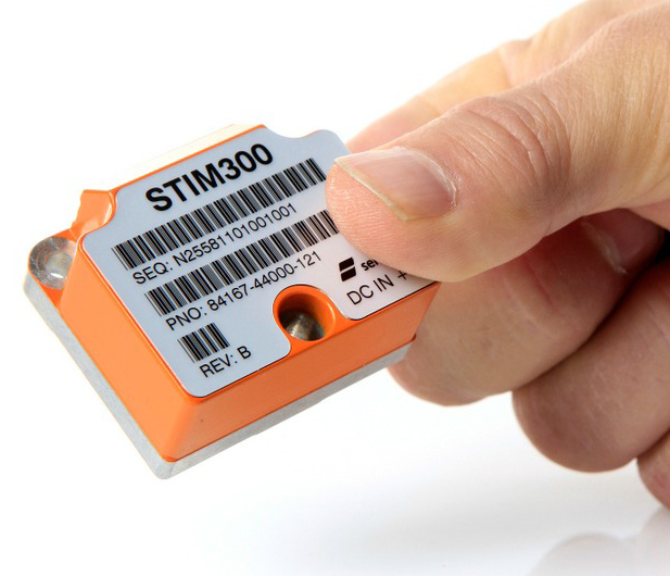
The STIM300 is a small, tactical-grade, low-weight, high-performance non-GPS aided IMU. It contains three highly accurate MEMS gyros, three high-stability accelerometers and three inclinometers. The IMU is factory calibrated and compensated over its temperature operating range.
The STIM series is designed for use below and on the ocean, on land, in the air, and in orbit and space. The STIM300 IMU is well suited for stabilization, guidance and navigation applications in the industrial, aerospace and defense markets. It is a crucial building block for inertial navigation systems in UAVs, AUVs, AGVs, UGVs and ROVs, Sensonor said.
The STIM300 is also used for camera turret stabilization and for use in various handheld devices that require a small IMU to secure operations during GPS outage.
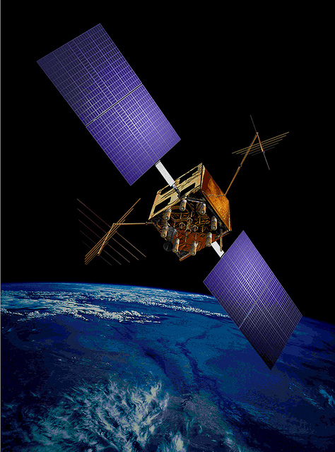
The U.S. Air Force’s fleet of GPS Block IIR and IIR-M satellites, manufactured by Lockheed Martin, have reached 200 collective years of operational life. The 20 satellites make up about two thirds of the current GPS constellation.
Originally launched between 1997 and 2009 to add capabilities to the GPS constellation and to replace other aging satellites, the 12 GPS IIR and eight IIR-M satellites have maintained an availability record of 99.96 percent, which represents only 10 minutes of down time per satellite during all their years of operation.
The 200-year milestone will be celebrated with a brief cake-cutting “ceremony” during ION GNSS, on Wednesday at 12:30 p.m., at the Lockheed Martin booth.
“This is a tremendous GPS operations and sustainment performance milestone, and we applaud the men and women of the Second Space Operations Squadron of the Air Force’s 50th Space Wing, as well as the industry team who support them,” said Mark Stewart, vice president for Lockheed Martin’s Navigation Systems mission area. “The world relies on GPS every day for things like synchronizing global banking and investing, shipping and transportation, search and rescue operations, ATM transactions and even precision farming.”
This spring, the IIR-M satellites played a major role in the continued modernization of the GPS constellation. To help manufacturers develop and test next-generation advanced civil GPS receivers, under the direction of Air Force Space Command and in collaboration with the Department of Transportation, these satellites began early broadcasting of test civilian navigation, or CNAV, messages on a new signal planned for all future satellites.
Making these milestones even more significant is the fact that the GPS IIR and IIR-M satellites were designed to last 7.5 years, or collectively about 150 years. All 12 IIR satellites are currently operating beyond their design life with the oldest operating for more than 16.5 years. Three of eight GPS IIR-M satellites have surpassed their expected life span and all satellites will have done so in 2017.
To meet evolving GPS user demands, Lockheed Martin is developing the next-generation GPS III satellites. These satellites will deliver three times better accuracy, provide up to eight times improved anti-jamming capabilities, and include enhancements which extend spacecraft life to 15 years, 25 percent longer than the newest Block IIF satellites. GPS III will be the first generation of GPS satellite with a new L1C civil signal designed to make it interoperable with other international GNSS.
Starting Friday, September 5, GPS satellite SVN-35 will resume transmitting L-band signals using PRN03, according to a Notice Advisory to Navstar Users (NANU) issued today.
According to GPS WorldAlmanac editor Richard Langley, the resumption is being done in an effort to determine the exact status of SVN-35’s remaining clock. However, the satellite will remain unusable as the Air Force conducts its tests.
Below is the full text of the NANU.
NOTICE ADVISORY TO NAVSTAR USERS (NANU) 2014069 NANU TYPE: GENERAL
*** GENERAL MESSAGE TO ALL GPS USERS ***
On approximately 05 Sep 2014 SVN35 will resume transmitting L-band utilizing PRN03. At L-band activation, SVN35/PRN03 will be unusable until further notice. Additionally, no broadcast almanacs will include SVN35/PRN03 until further notice.
Several weeks ago, I attended a National Geospatial-Intelligence Agency (NGA) Workshop conducted in Huntsville, Alabama. Of the numerous presentations, I found two especially interesting.
The first was a session by Sandra Broadnax, the director of the Small Business Programs Office for NGA. She gave a refreshingly energetic presentation about NGA’s efforts to build opportunities for small businesses in the geospatial community. The reason is twofold — NGA needs to meet federal guidelines to provide opportunities for small business, but even more important, NGA knows that there is a wealth of creative talent in the small-business sector that can address its requirements. So, if your firm is a small business, there may be some wonderful opportunities listed by NGA. And, very important, The agency is willing to help you get started. Go to www1.nga.mil, and click “Partners” and “Small Business Interaction” to get started. NGA also lists scholarships, internships and many unfilled full time positions.
Colonel Grimes
A second session, conducted by retired Army Colonel John Grimes, J.D. of the University of Alabama in Birmingham (UAB), caught me by surprise since it was so broad in scope and stretched everyone’s concept of how geospatial science fits into our increasingly complex and treacherous cyber world. Col. Grimes, a seasoned Army Intelligence Officer who oversaw a staff of 180 intelligence analysts in Afghanistan, is now part of a broad interdisciplinary team started at UAB in 2011 addressing the growing field of cyber crime and intelligence. This center of excellence is simply called “The Center,” and it brings together a wide collection of professors, students and professional partners across many disciplines. Their focus is simple: “Making the world a safer place for citizens of the 21st century.”
This broad effort is supported by experts in cyber, geospatial, human factors, data systems, forensics, psychology, medicine, chemistry and many others with financial support from Google, Facebook, Microsoft, eBay, UPS and even the FBI. You have to have a “dizzying intellect” just to wrap your head around their collective work, which is too complex to explain in this short article. But I’ll give you a brief summary of their organization, which is divided into divisions called Pillars:
INFORMATION ASSURANCE/SECURITY — The division deals with the basic design of information/data systems. Are the systems designed with security in place? Does the system provide access to authorized users while excluding those who are not? Do the systems protect the confidentiality, integrity, and availability of information and systems that process, store, and/or transmit data. This is the underpinning of secure data systems and unfortunately most are less than perfect and continually under attack. When attacked, the action becomes a cyber crime.
CYBER CRIME – This division is the pillar that addresses attacks on information systems. As you know, these attacks are becoming more frequent, more creative, significantly more disruptive and potentially very dangerous. I was surprised to learn that more than 85% of the world’s email is spam, and more than 20,000 phishing websites are created every month. So this really is the core of the work at The Center.
“The Center” at UAB.
INTELLIGENCE ANALYTICS – This is the division headed up by Col. Grimes. As a lawyer and intelligence expert, he completed numerous cyber-security projects for major banks and businesses, and this hands-on real-world experience prepared him to build The Center team that analyzes cyber crimes using a variety of tools, including human behavioral patterns and anomalies, electronic intelligence, imagery and unique digital signatures. This team determines the nature and scope of cyber-attacks. They work not only to identify the “content” of attacks and criminals, but to understand the more complicated, interwoven and far reaching “context” of the action in the big picture cyber world.
FORENSIC SCIENCE — This division has been doing traditional crime scene forensics for many years using lab forensics that many of us have seen on television. With the growth of cyber crime, the division has evolved and expanded its tradecraft into the digital domain, requiring the development of completely new tools and techniques that combine unique biological and electronic “signatures” and patterns of cyber criminals.
HEALTH INFORMATICS is a newly developed division that will deal with cyber crime issues related to healthcare and associated professions. This could be significant, since pundits have voiced concerns that the Affordable Care Act seems to have weak web security in place.
DATA SCIENCE is another new division focusing primarily on “Big Data” ranging from social-media data mining to video and persistent surveillance analysis and crowd sourcing.
Dr. Parcak at The Center.
GEOSPATIAL SCIENCE is the division that I and most of you will find especially interesting. The division is headed up by Dr. Sarah Parcak, FSA who is also associate professor in the Department of Anthropology and CEO of SpectralGlobe technologies, a company that specializes in the use of remote-sensing technologies. Dr. Parcak brings an impressive resume to the division, including extensive experience using remote sensing to identify archeological site looting, a major terrorist revenue source. A graduate of Yale University, she went on to earn her Ph.D. at Cambridge University, is a 2012 TED fellow, and has appeared on the Discovery Channel, BBC and CNN. She also a National Geographic Society Fellow.
The Geospatial Science team uses a combination of high-resolution aerial/satellite imagery coupled with traditional GIS vector data to map and analyze the Earth’s surface. Operating in the cyber realm, team members also map and analyze data that was not even on our GIS radar a decade ago — data such as cyber networks, nodes and servers, social media footprints and temporal changes using traditional imagery, and persistent surveillance imagery and video.
The team also leverages its key industry partnerships to use the most cutting-edge software and approaches to analyze layers of image data to detect subtle patterns that otherwise may be overlooked.
WORKFORCE DEVELOPMENT is an ultimate goal of The Center. Dealing with 21st-century criminals will require a workforce with skills and collections of skills that didn’t even exist 20 years ago. The students learn necessary technology and cyber skills to prepare them for entry-level and advanced positions in public and private organizations.
Opportunity
Talking with colleagues and staff at USGIF, there are other geospatial programs that have interdisciplinary collaborations with geospatial technology. However, UAB seems to have wrapped its arms around a powerful collection of talent and expertise to fill an urgent need while training cyber talent that is in great demand.
This column is a much-abbreviated description of The Center, so I strongly encourage you to visit the website, which contains a rich collection of information, papers and videoclips that describe the work and organization in detail. For more information contact Col Grimes at [email protected] or Dr. Parcak.
If you are a geospatial professional looking for a growing segment of our community, this looks like a very promising and most interesting career path.
A new event highlighting indoor location is being held this year at the ION GNSS+ Conference, which takes place September 9-12 in Tampa, Florida. The two-part event is scheduled for Wednesday, September 10.
The indoor location sessions are part of a new Commercial Track that also covers high-accuracy products, multi-constellation products, new consumer products such as wearables, MEMS, and simulation and testing.
The discussion will cover issues of standardization and certification from key organizations involved in indoor location, according to the ION GNSS+ program. Discussion will focus on the progress and issues for bringing indoor location to a level of standardization to allow penetration into all mobile devices.
Panel members include:
3GPP: Kirk Burroughs, Qualcomm
WiFi Alliance/IEEE: Marc Linsner, Cisco
Bluetooth Sig/OMA: Ian Blair, Cambridge Silicon Radio Ltd., UK
FCC/CSRIC: Chris Gates, Nextnav
Multiple: Steve Malkos, Broadcom
OGC: Hongwei Liu, MappedIn, Canada
MEMS Industry Group: Mahesh Chowdhary, ST Microelectronics
In-Location Alliance (ILA): Jounni Kamarainen, Nokia, Finland
Paul McBurney, GopherHush Corp., is guiding live indoor location demonstrations from 3:55 to 5:30 p.m. in Room 13-16. Demo areas will be set up around the edge of the conference room, and each presenter will have their demo running. In turn, each will talk about their demo from the stage. At the same time, there will be live video of the demo feeding to the big screen on stage. After the demos, panelists will be seated on stage to answer questions posed by the chair, and audience question moderated by the chair.
Demonstration partipants include:
RxNetworks, Ryan Reilly, “Resolving Indoor Location on Three Axes Using A-GNSS/Wi-Fi/ and Barometric Pressure”
Broadcom, Steve Malkos, “Enhanced Wi-Fi Ranging with Round Trip Time Measurements”
CSR, Dave Huntingford, “Indoor Positioning with MEMS, GNSS, Wi-Fi, Signals of Opportunity and Cloud-Based Learning”
PNI Sensor, Becky Oh, “Pedestrian Dead Reckoning (PDR) Using MEMS Inertial Sensors and PNI Sensor’s Ultra Low-Power SENtral Sensor Hub”
Indoo.rs, Markus Krainz, “Indoor Location Demonstration”
Navizon, Inc., Cyril Houri, “Navizon Indoors: A Pedestrian Navigation System Combining the Analysis of Wireless Signals (Wi-Fi, iBeacons) and Inertial Navigation”
Nokia, Jani Ollikainen and Hannu Laine, “Indoor and Local Positioning with BT Low Energy and Easy Installation”
ION GNSS+, sponsored by The Institute of Navigation, is considered the world’s largest technical meeting and showcase of GNSS technology, products and services. This year’s conference takes place September 8-12 at the Tampa Convention Center in Tampa, Florida.
ION GNSS+ will bring together international leaders in GNSS and related positioning, navigation and timing fields to present new research, introduce new technologies, discuss current policy, demonstrate products and exchange ideas.
Pre-conference events held Monday and Tuesday, September 8-9, include tutorials and the CGSIC meeting. The conference itself kicks off Tuesday with the plenary session, held 6:30-8:30 p.m.
This year, the plenary speaker is Tristan Gooley, navigator and explorer, who will discuss “The Wonderful World of Natural Navigation.” Gooley has led expeditions in five continents, climbed mountains in Europe, Africa and Asia, sailed small boats across oceans and piloted small aircrafts to Africa and the Arctic. He has walked with and studies the methods of the Tuareg, Bedouin and Dayak in some of the remotest regions on Earth. Gooley will describe how his love of the subject grew over time and explains how he learned to find his way using the sun, moon, stars, weather, plants and animals. He has used natural navigation in the Sahara desert, in jungles, on ice, on oceans and in the English countryside. He will explain how these ancient techniques can be used by anyone willing to try something new and how natural navigation can enrich all journeys, large or small.
Gooley’s talk will be followed by Panel Discussion Lightning Talks moderated by GPS World Publisher Alan Cameron. Presenters include Dr. John Betz, The MITRE Corporation; Didier Faivre, European Space Agency, France; Dr. Frank van Diggelen, Broadcom; Glen Gibbons, Inside GNSS; Oscar Pozzobon, QASCOM S.R.L., Italy; Dr. Frank van Graas, Ohio University; Dr. Todd Humphreys, The University of Texas at Austin; Dr. Dorota Grejner-Brzezinska, The Ohio State University; and Dr. Didier Flament, European Space Agency, France.
Technical sessions will be held Wednesday, Thursday and Friday. This year, a new commercial track has been added.
Samsung Electronics has unveiled its next-generation smart wearable device, the Samsung Gear S watch. The Gear S has assisted GPS+GLONASS, as well as 3G connectivity, allowing users to be active while always being able to access their smartphone information.
Designed with a two-inch curved Super AMOLED display and flexible band, the Samsung Gear S is also equipped with an accelerometer, a gyroscope, a compass, a heart rate monitor, and a barometer. The AMOLED display has an easy-to-use interface that allows users to read messages and notifications in a single glance with features such as conversation view and condensed font.
Connected to 3G networks, people can receive notifications from social networks, calendars and applications, even when away from their phones. Users can instantly receive incoming messages and easily reply to SMS using the onscreen keyboard or enhanced S voice functionality. The Samsung Gear S also lets users make and receive calls directly from their wrist as well as getting calls forwarded from a smartphone. The device lets users enjoy seamless communication by freely switching between connections, automatically connecting and synchronizing information once it is paired to a smartphone.
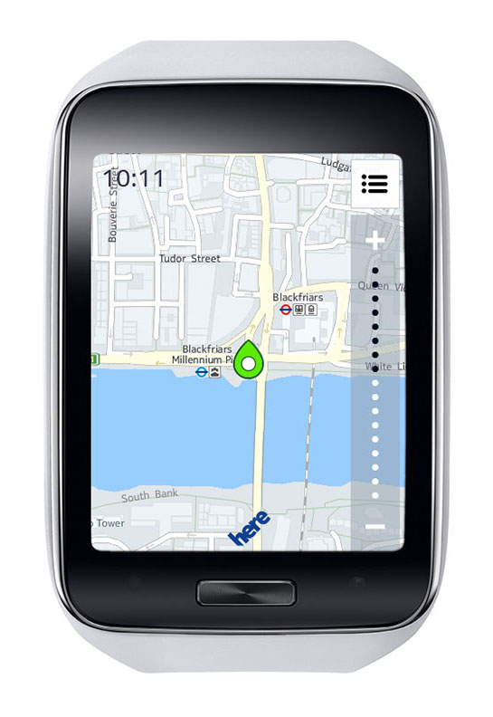
Samsung Gear S smart watch face detail. Photo: Samsung
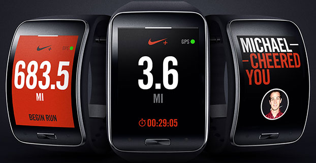
It also provides standalone features such as turn-by-turn pedestrian navigation provided by HERE. Health and fitness features include enhanced multi-sensors, built-in GPS, robust S Health features and applications like Nike+ Running so users can track their runs while leaving their smartphone at home.
“Samsung is leading the exciting and rapidly developing wearable category with continuous innovation that aims to enhance the lives of technology fans,” said Ines van Gennip, marketing director, IT & Mobile Division, Samsung UK & Ireland. “The Samsung Gear S is set to redefine the idea of the smart wearable device and the culture of mobile communication, enabling people to live a truly connected life anywhere, anytime.”