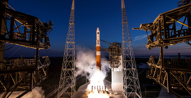
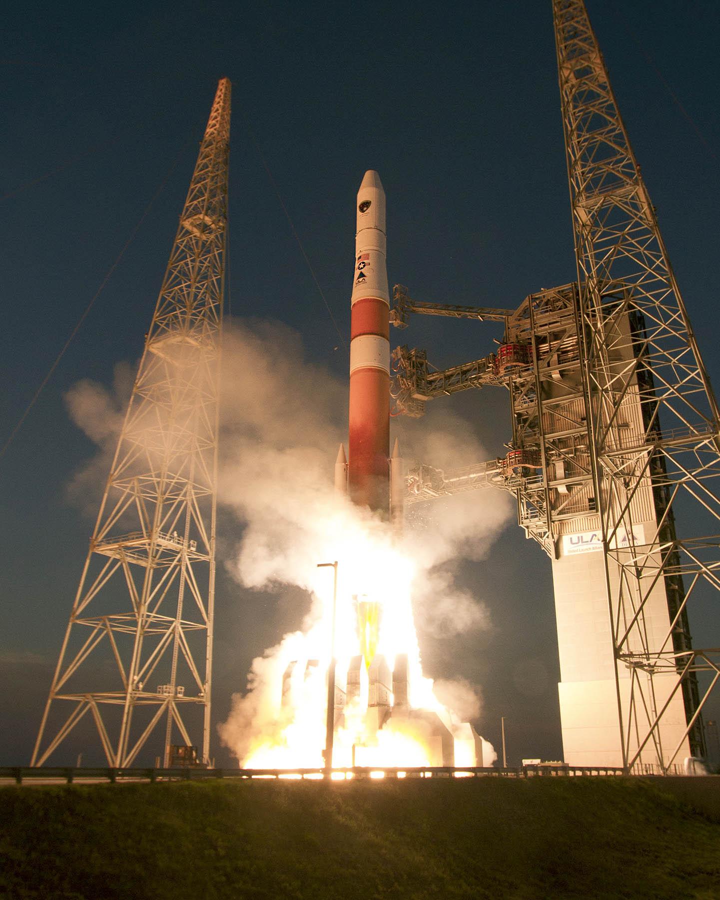
The GPS IIF-6 satellite was launched May 16. Photo credit: United Launch Alliance.
The Air Force is set to launch the seventh GPS IIF satellite this Friday.
An Atlas V 401 will launch the GPS IIF-7 mission for the U.S. Air Force on Friday, August 1, from Space Launch Complex (SLC)-41 at Cape Canaveral Air Force Station, Florida. The 18-minute launch window opens at 11:23 p.m. EDT.
A live webcast of the launch will begin at 11:03 p.m. EDT. To keep up to speed with updates to the launch countdown, dial the ULA launch hotline at 1-877-852-4321 or join the Facebook conversation and follow UA on Twitter using the hashtag #GPSIIF7.
GPS IIF-7 is one of the next-generation GPS satellites, incorporating various improvements to provide greater accuracy, increased signals, and enhanced performance for users.
The Air Force Second Space Operations Squadron indicates that IIF-7, SVN-68/PRN-3, will replace SVN-43 in the F plane slot 3 (F3). SVN-43 will be re-phased from F3 to the F2F slot to replace SVN-26. SVN-33 will be taken out of the operational constellation the day after SVN-68 launch and sent to Launch, Anomaly and Disposal Operations (LADO).
SVN-33 was launched on April 9, 1996, successfully serving over 17.5 years, 10.5 years beyond its design life. SVN-26 will back-up SVN-43 once it completes its re-phase journey.
Galileo’s Early Proof of Concept (EPOC) team has successfully tracked the encrypted Galileo E6-B and E6-C signals broadcast by Galileo satellites. As a result, the Commercial Service loop has been closed using both encrypted and non-encrypted signals, GSA said.
During a 10-day testing period, receivers in Tres Cantos, Spain and Poing, Germany, showed the successful tracking and data demodulation of the encrypted signals from the available Galileo satellites, with periods where all satellites transmitting E6 encrypted signals were tracked simultaneously. The tests verified the Galileo Commercial Service (CS) signal’s encryption functionalities, with the data received containing authentication and high accuracy information previously generated outside the Galileo system. This is an essential feature to ensuring Galileo’s high accuracy and authentication services — some of which may be commercial in nature.
“The Commercial Service has the potential to improve the performance of existing location services for all user communities and therefore will be a key element of Galileo’s service provision,” said Carlo des Dorides, Executive Director of the GSA. “It will also help further enhance the Galileo’s economic added-value in the downstream markets.”
The Galileo Commercial Service will deliver a range of added-value features, including positioning accurate to decimeter level and an authentication element, both of which allow for the development of innovative applications for professional or commercial use. The Galileo CS demonstrator began its proof of concept earlier this year, with early service expected to start in 2016.
Once operational, the CS will provide access to two additional encrypted signals on the E6 band, delivering a higher data throughput rate and increased accuracy. CS addresses the authentication and high-precision market segments and will deliver innovative services with improved performance and greater added value than those obtained through the open service.
“Although there are still many steps before the delivery of an operational CS, these first tests prove what Galileo can do in the near future,” said Ignacio Fernández Hernández, European Commission Officer in charge of the Galileo Commercial Service design and management.
The tests are the result of a collective effort involving teams and projects of AALECS (Authentication and Accurate Location Experimentation with the Commercial Service), supported by the European Commission, the GSA, the European Space Agency (ESA) and the Galileo operator Spaceopal.
The AALECS project is building a platform to connect to the European GNSS Service Centre (GSC) and transmit real time CS data through the Galileo satellites. This platform will be operational by 2015 and will demonstrate the real performance of future high accuracy and authentication services of Galileo prior to early service availability.
The European Commission launched AALECS in January 2014, and it was awarded to a consortium led by GMV including CGI, Qascom, IFEN, Veripos and KU Leuven. As part of the AALECS project, GMV and IFEN developed an early proof-of-concept platform aimed at testing external data transmission through offline means. The project will last for approximately two and a half years.
“This first successful demonstration shows the potential of Galileo to provide a new generation of innovative and high performance satellite-based navigation services,” said Miguel Romay, director of GNSS at GMV. “We are pleased to be part of the team developing the CS demonstrator and contribute to proving the capabilities of Galileo.”
At least some of the work on GPS III continues along prepared tracks, with the award of a Lockheed Martin contract to General Dynamics for two more satellites’ worth of communications hardware. General Dynamics Advanced Information Systems, a business unit of General Dynamics, was awarded a $25.4 million full-production contract from Lockheed Martin to support the GPS III Network Communications Element (NCE) for space vehicles seven and eight (SV 07-08). This commitment fills out that aspect of the current Lockheed Martin bevy of eight bought by the U.S. Air Force.
Many if not all components of the GPS III constellation beyond the Initial Eight have been called into question recently, with the U.S. Senate, the Air Force, and Lockheed itself keeping open minds about alternatives.
General Dynamics’ NCE components provide the communications functions for the GPS III satellites, including the ground-to-space command and control channel, the space-to-space inter-satellite channel and the command and telemetry communications channels within each satellite. General Dynamics is now under contract with Lockheed Martin for GPS III SV 01-08. Delivery of the NCE components for SV03 and SV04 are scheduled for this summer.
Compared to prior GPS vehicles, the Air Force’s GPS III satellites will deliver three times better accuracy, provide up to eight times more powerful anti-jamming capabilities and include enhancements that extend spacecraft life 25 percent further. GPS III-series satellites also will carry a new civil signal designed to be interoperable with other international global navigation satellite systems, enhancing civilian-user connectivity.
The majority of the work under contract will be performed at the General Dynamics Advanced Information Systems facilities in Scottsdale, Arizona, and Bloomington, Minnesota.
Tom Coughlin, head coach of the New York Giant football team, has outfitted his players with GPS devices strapped to their backs under their uniforms. The technology can provide the team with information such as top speed, burst and how long the player has run in terms of time and miles, reports the Wall Street Journal.This is the second year the team has used GPS during training.
“We’re getting all kinds of information,” Coughlin said. “It’s player related so we have information coming every day on every player.”
The data can help the coaches structure practices so they know when to do extra stretching or potentially cut down on repetitions. Some of the players use the information as a means of competition, comparing top speeds and workloads.
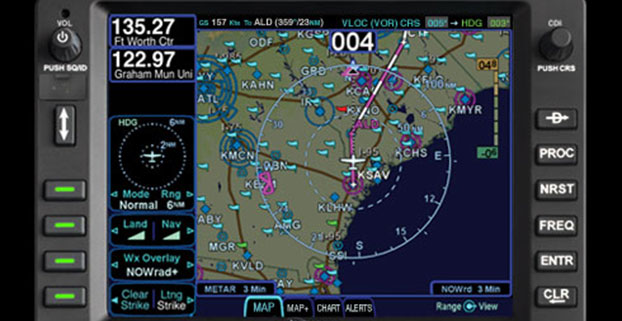
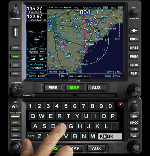
Avidyne Corporation, a provider of integrated avionics and safety systems for general aviation aircraft, has received Technical Standard Order (TSO) approval and an Approved Model List Supplemental Type Certificate (AML-STC) from the Federal Aviation Administration (FAA) for installation of the IFD540 FMS/GPS/NAV/COM system in more than 1,000 aircraft makes and models.
“The IFD540 gives aircraft owners a truly exceptional choice over anything else available today for GPS and VHF NAV/COM capabilities,” said Patrick Herguth, Avidyne’s chief operating officer. “The IFD540 delivers the perfect combination of touchscreen and dedicated-button user interface, making it much easier and more enjoyable for pilots transitioning from previous-generation systems.”
“The IFD540 adds significant improvements in functionality and ease of use, while providing huge cost and time savings for a large number of aircraft owners looking to upgrade their obsolete GPS systems,” said Dan Schwinn, Avidyne’s president and CEO. “Our ‘plug-and-play’ strategy opens up a huge market for aircraft owners who want new features like rubber-band flight plan editing, WAAS and ADS-B, but at a lower cost and with quicker installs.”
The IFD540 is the centerpiece of Avidyne’s previously announced stack of plug-and-play panel-mounted avionics, which also includes the AMX240 Audio Panel and the AXP340 Mode S ADS-B Transponder, both of which are already TSO’d and available now.
A smaller-screen version of the IFD540 called the IFD440 FMS/GPS/NAV/COM is planned for availability later this year.
Rounding out Avidyne’s panel-mounted avionics stack is the DFC90 digital Autopilot with Envelope Protection and Envelope Alerting, which has already been certified on a number of aircraft including Cirrus SR20/22, Piper PA-46, Beech Bonanza series, and Cessna 182 series.
The growth of precision farming market is expected to be remarkable, and is estimated to reach $3.7 billion by 2018, at an estimated CAGR of 13.36% to 2018, according to a report by ReportsnReports. The global population is expected to rise up to nearly 7.5 billion by the year 2020, and the ability to manage and tackle the ever-increasing demand for food will in all likelihood continue, the report says.
Climate Change. Global warming continues to be an influential deciding factor in determining agriculture productivity, as well as soil properties and sustainability of natural resources. The effect of climate change on agriculture is related to variability in local climates rather than global climate patterns. All these concerns marked the way for the entry of the new world of agriculture management practices, the report says. Precision farming can significantly reduce the amount of nutrient and other crop inputs used while boosting yields. Farmers, thus, obtain a return on their investment by saving on phytosanitory and fertilizer costs. The second large-scale benefit of targeting inputs in spatial, temporal and qualitative terms reduce concerns of environmental impacts, the report says.
The major drivers for this market are augmented yield and profitability, which are the major contributing factors for farmers to go for precision farming; other drivers like energy and cost saving and government assistance have also been contributing to the market growth. Major restraints such as high initial investments, and lack of awareness and their impact analysis, are also covered under this study. North America leads the market share for precision farming as this region has the maximum adoption. The Asia-Pacific region (APAC) is the emerging market for precision framing and has been enjoying the highest growth rate among all the geographic regions. It is believed that the APAC market will grow at a CAGR of 25.16% from 2013 to 2018.
The report covers all the technologies, components, and applications of precision farming; it provides a detailed analysis of the current market scenario and estimation for the next five years. Major applications like field mapping and yield monitoring are driving the market. Moreover, the market is driven by some of the most important technologies like GPS and variable rate technologies. This market is already progressing well in developed countries, and it is also expected to grow well in developing nations as a result of their ever-growing food demands.
Companies like Ag Business & Crop Inc., Ag Leader Technology, Ag-Nav Inc., Agco Corporation, Agjunction Inc., Agri Con Gmbh, American Sensor Technologies Inc., Autofarm, Automata Inc., Deere & Company, Dickey-John Corporation, Echelon Ag Inc., Jain Irrigation Systems Ltd., Omnistar, Planting Inc., Precisionagriculture.Com.Au, Raven Industries Inc., Soyl Precision Farming, Teejet Technologies, The Toro Company, Topcon Precision Agriculture & Trimble Navigation Limited are profiled in this research available for purchase.
This report profiles companies which are major players, and are active in this market. The report presents the ‘competitive landscape of the players’ that covers key growth strategies followed by all the major players.
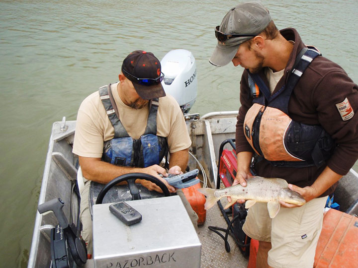
A Utah DWR field crew rides along in an electrofishing boat.
The Utah Division of Wildlife Resources (DWR) is using rugged Juniper Systems handhelds in an innovative way: to remove an invasive fish species from the Green River so that native fish can flourish.
A DWR field crew first used the Allegro MX handheld, loaded with custom fisheries software, to monitor native fish species and remove invasive fish in a 2013 project along the Green River, located near Dinosaur National Monument in Utah’s northeast corner.
The field crew’s work involved boat electrofishing, in which the researchers ride along in a boat with electrodes protruding into the water. The electrodes send out an electrical current, temporarily stunning the fish.The fish float to the surface, where they are netted and inspected.
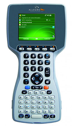
Invasive fish are collected and removed from the river. Invasive species can degrade fisheries habitats and harm the ecosystem. Right, the Allegro MX handheld.
Every five miles, the crew stopped the boat and collected data on the fish. In a single day on a 12-mile stretch of the Green River, the crew caught 2,800 fish.
When a native species was caught, the fish was given a passive integrated transponder tag. Data was collected about the fish, and then it was released. When an invasive species was netted, however, it was kept for later data collection, and then removed from the river. Invasive species — fish transplanted from another location — can outcompete native fish, degrade fisheries habitats, and harm the ecosystem.
With high-value native fish, the team took a GPS point and collected data on the species, length, weight, sex, ripeness, and more, explained Juniper Systems’ natural resources market manager Trevor Brown, who accompanied a crew.
Brown explained that understanding the location of native fish helps fisheries biologists determine the effectiveness of previous removal efforts: Are native fish prospering in areas where invasive species were previously removed? Location also helps biologists associate where native fish are caught with habitat characteristics, which helps guide more targeted invasive removal efforts.
Allegro MX handheld.
Because the Green River is a a major tributary of the Colorado River, the boat crews submit their data to a central database that supports a larger effort to understand the status and health of fisheries systems of the entire Colorado River watershed. The information is used to guide management and policy decisions, fish regulations, and fisheries research.
“Location-specific data can help biologists understand population and dispersal of both native and non-native fish at a macro level,” Brown said.
The Utah DWR made the switch to the Allegro MX after seeing its benefits, including its full alpha-numeric keyboard, which allowed for rapid, accurate data entry, as well as its extreme ruggedness, sunlight-readable display, integrated GPS, and RFID compatibility.
The team even found the Allegro MX, rated IP67, could float — an additional bonus when working along a river in a shallow craft.
Brown customized the fisheries software for the Utah DWR field crews. The crews previously collected data using pen and paper, and then manually entering it into Microsoft Excel, a time-consuming and error-prone process. The custom fisheries software, available through Juniper Systems, reflects the data that needs to be collected, with required data fields and streamlined data entry. Because many of the Utah DWR crews are made up of seasonal workers, Brown designed the fisheries app to be easy to learn and use.
Biologists use the Allegro MX to collect data on the fish, including this endangered razorback sucker.
Northern Pike. Besides boat electrofishing, the fisheries software can be used for other applications, including an invasive fish removal application called fyke netting. Shaped like a bag with several hoops forming its structure, a fyke net acts as a funnel to trap swimming fish. The Utah DWR uses fyke nets primarily in the spring to trap invasive northern pike while they are spawning. After setting the fyke nets, crews return to check them and collect data on the trapped pike.
The fisheries software is also used for tributary electrofishing data collection, in which wader-clad crews walk along tributaries with electrofishing backpacks, shocking the water. As in boat electrofishing, the crews collect the invasive fish for later data collection, and they tag and collect data on native fish before releasing them.
The team experienced significant improvement with the new data collection process. “[The fisheries software] greatly reduced the data-entry time to the point where it has already paid for itself,” said Joe Skorupski, Native Aquatics Biologist at the Utah DWR. “Last year with three people, we took over 200 hours to enter, verify, and manipulate data. This year, it took one person 20 hours and errors were nonexistent due to the software and new data-collection process. I could go on and on about all the great improvements due to the handheld and the software.”
Since 2013, the Utah DWR has expanded its use of the Allegro MX and software for parallel projects, such as native fish sampling on fast-moving sections (Flaming Gorge) of the Green River, where fewer invasive fish are present.
Where are bets on new technology being placed? Prominent venture capital (VC) firms are investing in companies with indoor location solutions. But with more than 50 companies to choose from and at least ten unique technologies, it is hard to judge who will make it into the winner’s circle. There is no early leader to put money on, and unlike other location-based markets like mapping, I expect this market to support many competitors and not be dominated by a few. The vertical markets that are ripe for indoor location have different needs for accuracy, cost and speed. Promising applications include retail, advertising, manufacturing, asset tracking, gaming, intelligence and public safety, but who knows what other applications will emerge. GPS has infiltrated everyday life in ways unimagined at its start.
With no obvious front-runner technology, many companies hedge their bets and offer multiple technology solutions. With infrastructure already installed throughout the great indoors, the easiest solution may appear to be Wi-Fi triangulation. While the cost may be attractive, the accuracy is not precise enough for many apps. Other solutions include Wi-Fi fingerprinting, Bluetooth, sensors and beacons.
Some companies are offering technologies outside of the mainstream. ByteLight provides a solution based on LED lights mounted in the ceiling that generate fast pulses that can’t be seen by people. A smartphone can detect the pulses and triangulate position by identifying different lights by pulse pattern. Indoor Atlas and Indoo.rs use sensors to detect Earth’s natural magnetic fields for positioning. Camera technology is being used by WhereLab and Omiimii. Object recognition software determines location.
The accuracy requirements of applications will drive the choice of technologies. Low accuracy is more than 11 meters, and medium accuracy is six to ten meters. High accuracy is one to five meters. High-accuracy solutions are generally more expensive and require more infrastructure.
Apple iBeacon Changes to Opt-Out
Anything that Apple does garners attention, including iBeacon for indoor location, which uses low-energy Bluetooth to communicate to phones and computers. Apple has some showcases, including a few Eagle and Safeway grocery stores using the iBeacon to send marketing messages to customers. The Peeble smartwatch added iBeacon support and reportedly can zero in on a lost phone. iBeacon technology at some of the Virgin Atlantic gates can trigger an app to automatically display a boarding pass as a traveler approaches. BeHere automates classroom attendance.
I often write about privacy issues, and so I wonder, where are the techno-privacy advocates challenging Apple on iBeacon? You would think that there would be a tangle of permissions required of users, including turning on the beacon and giving an app permission to locate the user and for receiving notifications. Apparently, Apple thought the permissions were unwieldy. Apple users had to opt-in to turn on iBeacon, but in March with the new iOS release, the default changed to opt-out.
Apple users may be unaware that an app using iBeacon doesn’t need to be open to interact with the phone. If the Safeway app is installed, the user will receive messages from the store, even when the app isn’t running and phone screen is locked. Even though iBeacons don’t track users or collect data from them, I find this functionality to be unsettling.
Advertising in Minority Report was very personal.
Stores are having trouble competing with online shopping and are looking for ways to interact with shoppers when they come through the door. That interaction might be loyalty points, greetings or personalized special offers. Only three percent of retailers currently have the ability to identify customers coming through their doors, according to a survey of top retailers by Boston Retail Partners. ABI Research predicts beacons will be installed at 30,000 locations worldwide by year’s end. If beacons alone can generate such widespread usage so quickly, it is easy to see why indoor positioning technology companies have been a magnet for VCs.
Do you remember the scene in the movie Minority Report when Tom Cruise enters a clothing store? As Cruise passes by advertisements, they address him by name. Indoor location can get creepy.
Proximity and indoor positioning will grow as technology gets better — and consumers value its benefits. Attendees at the recent Place conference in New York had the opportunity to hear from companies who advocated Bluetooth, Wi-Fi and even magnetic positioning technology. In addition, several advertising agencies and retailers attended, showing that the nascent proximity/indoor location niche could be a major market in the next few years.
NEW YORK — The potential for indoor positioning and proximity marketing is huge if even a fraction of overall retail sales are attributed to the information the technology gives to retailers, said panel members at the July 22 Place conference here.
The indoor opportunity is huge as studies have shown that 70 percent to 89 percent of consumers use smartphones in stores to compare prices and shop for coupons, said Greg Sterling, Opus Research senior analyst. “About $20 to $50 billion of purchases were influenced at point-of-sale in stores. $500 billion of retail sales came without any premeditated product selections,” he said. “Even if a small fraction shifts to mobile devices, that’s an enormous amount of money.”
Sterling said that despite consumers’ ambivalence to privacy issues, if they are guaranteed some sort of benefits to being tracked, they will opt-in. “72 percent said they don’t want tracking [without benefits]. That number goes up to 66.4 percent who say ‘yes’ if there are specific benefits — rewards and discounts,” he said. “It is about educating consumers [as to benefits of location-based advertising].”
Technology improvements and retailer awareness in the last two years have made such mobile advertising agencies as Joule interesting in location as a data point beyond geofencing, said Michael Lieberman, company co-president.
“I am biased as we are mobile agency, so for us, most of our clients are using location to identify buyers. Ideally, we see a device in multiple locations, we understand consumers’ behavior,” Lieberman said. “If I see you every morning at a Starbucks, you are a coffee drinker and I should target you that way. However, if you are trying to use location as a national campaign you will only get a percentage of accuracy — you are missing out on other information.”
Right now, retailers have little idea how and why a consumer makes a purchase, Lieberman said. “The [important] point is in [indoor location’s] measurement — what happens in the store environment. You walk in store, make a purchase, right now we have no idea what they did to buy a product,” he said. “We are losing that piece — and it is a big gap in thinking. Everything about consumer path in that store determines a purchase. What’s valuable is the in-store data that gives you the most actionable information.”
Location today is used for targeting, but not for the total consumer measurement that Facebook requires, said Doug Stotland, Facebook product marketing director. “IKEA recently ran a campaign in a local radius, they wanted to see who showed up in their parking lot,” Stotland said. “It’s really compelling when you look at the methodology — you want to see if people actually showed up at the store. The home run is how to tie it to what they actually buy.”
Stotland said Facebook uses location information for targeting, but basically users tell the company where they live and that’s it. “We can do better than that — there is definitely a big opportunity there. The great thing about Facebook is that I am always logged in — there is no value for targeting if I am not.”
In a case study session at Place, Korean telecom provider SK Telecom has been making inroads in indoor positioning markets for several years, said John Kim, SK Telecom senior business development manager. “While we are the number one mobile operator in Korea, like other companies, we were hitting saturation levels,” Kim said. “We found that location-based services for telecos are a key service, basing this on earlier tracking, navigation and security markets.”
SK Telecom ran indoor positioning tests at Seoul National University Hospital, which has 1,360 beds, making it hard to find patients. Kim said younger indoor positioning users liked the service and found it easy to use. “We also found that it was difficult for active marketing — what does a hospital use to promote it? Two-for-one x-rays?” Kim said. “The service was also difficult for remote maintenance and support.
Kim said that SK Telecom is installing the product as a test in a Seoul sports stadium and at the L’Oreal Madrid flagship store. “We are also partnering with [Herndon, Va.-based] APX to work in their Google Glass product to provide location information.”
Overall, the upside of indoor location is huge, said Don Dodge, Google developer advocate. “Imagine if you can look at phone to know exactly what stores your family members are in at the mall. At CES, you have no idea where 15 to 20 of your friends are,” he said. “If my wife gives me a list of groceries, I can find them in certain areas and know what price they are. First responders, fire departments, can find their way around in a burning building — and find a safe way out.”
Privacy: The Attack on Opt-In
In a privacy panel, members put a dark cloud over the ubiquitous answer by many companies that consumer opt-in alleviates all concerns for the location industry.
Amanda Koulousias, a Federal Trade Commission attorney, said Section Five of the FTC Act, which has been expanded to cover tracking users over a certain time, prohibits deceptive practices that are likely to mislead people acting reasonably.
Privacy seems to be a hot topic for reporters. Kate Kaye, a panel member who is a reporter with Advertising Age, said that security issues around beacons and leakages is a story. She also said that the Associated Press recently ran a story critical of the new Verizon rewards program. “The story typifies the balance a lot of marketers are trying to straddle — how much information can we gather, and how do we not [anger] consumers. Verizon Wireless prompts you to join their loyalty rewards program, but you have to opt-in to their location data program,” she said.
Privacy panel moderator Jules Polonetsky, Future of Privacy Forum executive director, said a way some companies get consumers to opt in to being tracked is just to say “download this app.”
The location industry’s privacy issues are not going away — and the path for resolution isn’t clear, said Greg Turetsky, principal engineer in Intel’s wireless communications group. “The privacy issue is so complex legally, economically and socially, that I expect it will not be resolved any time soon,” he said.
In other Place conference news:
Opus Research, the organizer of the conference, published a report on magnetic positioning, which has a unique footprint. The company contends that magnetic positioning, which can be complimented by other technologies, offers six-foot accuracy with 90 percent precision. In comparison, Bluetooth offers proximity, but not the blue dot solution magnetic positioning currently has. In addition, Opus believes that Wi-Fi positioning, which has 40-foot accuracy, needs too much support and is expensive.
Epson America has introduced its next-generation family of large-format color printers — the Epson SureColor T3270, T5270, T7270, T5270D, and T7270D. Available in both single- and now dual-roll models, the SureColor T-Series features the Epson PrecisionCore TFP print head and Epson UltraChrome XD pigment ink to provide technical, corporate and marketing professionals an unprecedented combination of precision, performance and brilliance, the company said. The new line will be available in September.
“The next-generation of SureColor T-Series printers were designed based on direct feedback from customers who demand cost-effective, versatile and scalable printing solutions,” said Timothy Check, product manager, Professional Imaging, Epson America, Inc. “The new SureColor T-Series printers not only meet the specific requirements of today’s engineering and scientific professionals, they incorporate the latest in printing technology to create accurate large-format prints well-suited for a variety of projects and applications, ranging from CAD drawings and GIS maps to corporate graphics and retail posters.”
The Epson SureColor T-Series delivers extreme line accuracy with resolutions up to 2880 x 1440 dpi at incredibly fast speeds — producing a presentation quality D-size plot in as little as 25 seconds, the company said. For increased efficiency, the SureColor T-Series single-roll printers use a horizontal catch basket for enhanced output stacking, while the dual-roll printers feature a high-capacity catch basket for quick retrieval and reduced sorting time.
In addition, the SureColor T-Series 36- and 44-inch printer models offer an optional multifunction (MFP) module, enabling PC-free full-color scan and copy capabilities — up to 36-inches wide — at best-in-class speeds for added convenience. In addition, ergonomic design with intuitive copy and scan-to-share capabilities ensures seamless integration to maximize workflow performance, Epson said.
The SureColor T-Series is comprised of five printer models, offering varying performance and feature sets to accommodate a range of printing needs:
The SureColor T3270, T5270, T7270, T5270D, and T7270D offer a range of value-added features that help lower total cost of ownership and increase productivity, including:
Three printer widths: The SureColor T-Series features maximum print widths of 24, 36, and 44 inches, with minimal floor space requirements to fit virtually anywhere.
Optional multifunction MFP: An optional upgrade for 36- and 44-inch single- and dual-roll T-Series models, the PC-free MFP Scanner leverages Epson’s REALOID image processing engine to produce crisp color D-size copies in under 40 seconds, and best-in-class color scan speeds up to 6.0 inches per second — maximizing productivity.
Epson UltraChrome XD ink: Epson pigmented ink delivers brilliant color and crisp lines on virtually any paper type, as well as truly archival and extremely smudge and water-resistant output; the SureColor T-Series printers are designed to be used exclusively with these specially-formulated inks, and not with other brands of cartridges or inks.
Varied ink capacities: To maximize efficiency and keep printing costs low, each of the five ink colors — cyan, magenta, yellow, photo black, and matte black — are available in 110 ml, 350 ml and high-capacity 700 ml cartridge sizes, which can be used interchangeably to accommodate a range of printing needs; all cartridges are front-loading for easy access.
Epson PrecisionCore TFP print head: Offers high-performance and consistency for accurate plotting with high-precision line detail and minimum line widths as thin as 0.018 mm, along with variable size ink droplet technology for remarkable photographic print quality
Current and future-ready print language: Epson Precision XD printer language sets a new standard for high-performance, high-resolution printing, compatible with today’s latest applications and workflow software
Optional internal print server: An internal 320GB print server boosts workgroup productivity by quickly transferring print jobs to free-up workstations; adds print queue management, as well as print job save and reprint functionality.
Optional True Adobe Postscript 3 hardware engine: Fastest in-class postscript engine enables direct and hot-folder batch printing and support for secure PDF printing; includes the optional internal print server hardware.
Control panel: Full color LCD panel with simple button layout provides quick access to printer features and controls, as well as an intuitive help system for most frequent tasks
Professional media handling: Supports virtually any media type in roll or cut-sheet, from plain bond paper to 1.5 mm thick posterboard, for use with a wide variety of print applications.
InvenSense, Inc., a provider of intelligent sensor solutions, has signed a definitive agreement to acquire Trusted Positioning, Inc. (TPI), a privately held indoor/outdoor tracking company with the vision to provide “Positioning Everywhere.” InvenSense is also acquiring context analysis software company Movea.
TPI’s location tracking technology improves accuracy both indoors and outside by augmenting GNSS and Wi-Fi based location infrastructure. Using inertial sensors such as accelerometers, gyroscopes, magnetometers, and pressure sensors in mobile and wearable devices, TPI’s software platform provides continuous and accurate positioning and also solves the difficult problem of alignment between the user and the mobile device. The TPI platform provides complete inertial navigation software solutions for a variety of industries including smartphones, tablets, wearables, in-vehicle navigation, personnel tracking, and machine guidance and control.
“InvenSense shares our passion for ‘positioning everywhere,’ and they have been a strong supporter of the Trusted Positioning team, technology and vision,” said Chris Goodall, Trusted Positioning’s chief executive officer. “We are pleased to be joining the InvenSense family with the goal of making indoor/outdoor positioning ubiquitous. Together with InvenSense we will now have the required resources and investment to mainstream this technology.”
InvenSense has also signed a definitive agreement to acquire Movea, a privately held company that provides software for ultra-low power location, activity tracking, and context sensing. Movea’s products, technology, and IP cover a broad range of signal-processing and data-fusion technology applied to consumer mobile (smartphones and tablets), TV interaction, and wearable sports and fitness applications.
Movea is dedicated to context analysis using both motion and audio sensors to determine, for example, a person’s state/activity, their energy expenditure, their location, and an athlete’s speed and cadence. Movea’s algorithm and software framework expertise is expected to further scale InvenSense’s leadership in motion software and accelerate InvenSense’s “AlwaysOn” low-power solutions for mobile and the Internet of Things.
“With the addition of Movea and TPI, InvenSense achieves a significant milestone as it transitions to a leading provider of intelligent sensor System on Chips (SoC) for the fast growing mobile market. ‘AlwaysOn’ location and activity tracking are essential to enabling contextually aware products and services,” said Behrooz Abdi, president and chief executive officer, InvenSense. “The tight integration of our low-power, high performance, motion and sound sensors, along with TPI’s advanced location tracking software and Movea’s data fusion algorithms, will position us to deliver on this ‘AlwaysOn’ promise.”
In connection with the acquisition of both companies, InvenSense expects to pay approximately $81 million, net of cash assumed, to acquire all of the outstanding shares of capital stock and other equity rights of Movea and Trusted Positioning, Inc. The purchase price will be paid with $6M of InvenSense common stock and the remainder in cash, except that portion attributable to unvested employee stock options will be paid in stock options exercisable for shares of InvenSense’s common stock.
A portion of the cash consideration payable to the stockholders will be placed into escrow pursuant to the terms of the acquisition agreement. The estimated financial impact of the acquisitions upon the future operating results of InvenSense, which is not expected to be significant, will be discussed during the next regularly scheduled quarterly investors analyst conference call planned for July 29.
The boards of directors of InvenSense and the two companies have approved the mergers. The transactions are expected to close by the end of InvenSense’s second quarter, September 30, and remains subject to the satisfaction of regulatory requirements and other customary closing conditions.
NovAtel, Inc., is offering a promotion for existing customers, on the company’s recently launched NovAtel CORRECT with TerraStar PPP subscription service. The promotion will run until September 30, 2014.
Promotion Details
Customers using NovAtel legacy equipment (OEMV generation receivers or earlier) or NovAtel’s current OEM6 technology, qualify for the following offers:
Trade in legacy NovAtel hardware for a FlexPak6, antenna and one-year TerraStar subscription for $4995.
Buy a minimum one-year TerraStar subscription for any OEM6 receiver and get a NovAtel CORRECT PPP receiver firmware upgrade for free.
Customers who want to learn more or take advantage of this promotion can call 1-800-668-2835 or email: [email protected].