The U.S. Patent and Trademark Office has issued 10 U.S. patents to TeleCommunication Systems, Inc. during the second quarter of 2014. TCS also received two foreign patents during the quarter.
The 10 U.S. patents describe innovations in messaging, location-based services, GIS/mapping and wireless. They include the following three:
TCS reported in the first quarter that it was issued a Prepaid Short Messaging Services patent. In the second quarter, TCS received notice that another prepaid patent was issued to the company that will serve as one of the cornerstone patents in a monetization program that TCS is planning to launch later this year. The prepaid market has grown into a multibillion-dollar per year industry, with 86 million prepaid users comprising 27 percent of all U.S. wireless users, according to a J.P. Morgan 2013 market report. The recently issued Prepaid Short Messaging patent (U.S. 8,738,496) is a continuation of earlier TCS prepaid patents, bringing TCS’ prepaid messaging portfolio to eight, with one additional pending. Most prepaid phone systems allow users a prescribed amount of prepaid messaging and wireless call time. The ‘496 patent describes techniques for determining if a recipient’s account is sufficiently funded to receive a message. If it is not, the system prevents the delivery of messages until the recipient’s account is sufficiently funded, when follow-on messages will be delivered.
A geofence defines a virtual spatial boundary for creating triggers when a mobile device either enters or exits that boundary. Geofences are commonly used in child location services to alert parents when a child’s mobile device leaves the boundary of a school or park, or by enterprises to track the location of a mobile workforce or equipment. Establishing a geofence can be complicated, requiring that the user manually draw the boundary on an electronic map. The recently issued TCS patent covering a Method and System for Identifying and Defining Geofences (U.S. 8,731,813) describes techniques to simply and easily create geofences based on real-world objects or places. Using the map/navigation application on a mobile device, the user simply selects the desired location, using its pre-defined boundary to create the geofence.
Thousands of portable computing platforms have emerged that have the capability of directly connecting to the Internet either through a wireless wide area network (such as cellular network or campus Wi-Fi network) via a front-end built into the device (smartphone, etc.), or, via Bluetooth or other short-range wireless communication, to a wireless proxy device such as a modem or a smartphone. With various low-cost, short-range wireless devices installed in vehicles for navigation or entertainment purposes, it has become increasingly important to provide an easy and efficient method for a motor vehicle manufacturer, parent or other authority to monitor and control access to certain sites when those devices are connected to the Internet. The recently issued Remotely Provisioned Wireless Proxy patent (U.S. 8,712,408) describes techniques to create white lists (allowed URLs) and black lists (disallowed URLs) within a wireless/mobile device acting as a proxy so that access to certain sites can be controlled effectively.
The remaining seven U.S. patents issued in the period are: Integrated, Detachable Ear Bud Device for a Wireless Phone (U.S. 8,688,174); N-Dimensional Affinity Confluencer (U.S. 8,688,087); Login Security with Short Message (U.S. 8,712,453); Intelligent Reverse Geocoding (U.S. 8,731,585); Secure Location Session Manager (U.S. 8,687,511); System and Method for Location Assurance of a Mobile Device (U.S. 8,718,673); and Wireless Network Tour Guide (U.S. 8,744,491).
The U.S. Patent and Trademark Office has issued 10 U.S. patents to TeleCommunication Systems, Inc. during the second quarter of 2014. TCS also received two foreign patents during the quarter.
The 10 U.S. patents describe innovations in messaging, location-based services, GIS/mapping and wireless. They include the following three:
TCS reported in the first quarter that it was issued a Prepaid Short Messaging Services patent. In the second quarter, TCS received notice that another prepaid patent was issued to the company that will serve as one of the cornerstone patents in a monetization program that TCS is planning to launch later this year. The prepaid market has grown into a multibillion-dollar per year industry, with 86 million prepaid users comprising 27 percent of all U.S. wireless users, according to a J.P. Morgan 2013 market report. The recently issued Prepaid Short Messaging patent (U.S. 8,738,496) is a continuation of earlier TCS prepaid patents, bringing TCS’ prepaid messaging portfolio to eight, with one additional pending. Most prepaid phone systems allow users a prescribed amount of prepaid messaging and wireless call time. The ‘496 patent describes techniques for determining if a recipient’s account is sufficiently funded to receive a message. If it is not, the system prevents the delivery of messages until the recipient’s account is sufficiently funded, when follow-on messages will be delivered.
A geofence defines a virtual spatial boundary for creating triggers when a mobile device either enters or exits that boundary. Geofences are commonly used in child location services to alert parents when a child’s mobile device leaves the boundary of a school or park, or by enterprises to track the location of a mobile workforce or equipment. Establishing a geofence can be complicated, requiring that the user manually draw the boundary on an electronic map. The recently issued TCS patent covering a Method and System for Identifying and Defining Geofences (U.S. 8,731,813) describes techniques to simply and easily create geofences based on real-world objects or places. Using the map/navigation application on a mobile device, the user simply selects the desired location, using its pre-defined boundary to create the geofence.
Thousands of portable computing platforms have emerged that have the capability of directly connecting to the Internet either through a wireless wide area network (such as cellular network or campus Wi-Fi network) via a front-end built into the device (smartphone, etc.), or, via Bluetooth or other short-range wireless communication, to a wireless proxy device such as a modem or a smartphone. With various low-cost, short-range wireless devices installed in vehicles for navigation or entertainment purposes, it has become increasingly important to provide an easy and efficient method for a motor vehicle manufacturer, parent or other authority to monitor and control access to certain sites when those devices are connected to the Internet. The recently issued Remotely Provisioned Wireless Proxy patent (U.S. 8,712,408) describes techniques to create white lists (allowed URLs) and black lists (disallowed URLs) within a wireless/mobile device acting as a proxy so that access to certain sites can be controlled effectively.
The remaining seven U.S. patents issued in the period are: Integrated, Detachable Ear Bud Device for a Wireless Phone (U.S. 8,688,174); N-Dimensional Affinity Confluencer (U.S. 8,688,087); Login Security with Short Message (U.S. 8,712,453); Intelligent Reverse Geocoding (U.S. 8,731,585); Secure Location Session Manager (U.S. 8,687,511); System and Method for Location Assurance of a Mobile Device (U.S. 8,718,673); and Wireless Network Tour Guide (U.S. 8,744,491).
Organized by decade, the interactive map lets users explore inductees in the Pro Football Hall of Fame from the initial class in 1963 to this year’s seven inductees. Users can see where each gridiron great is from and explore biographical information from the Pro Football Hall of Fame about each inductee.
American Sentinel University’s new e-book, GIS for Crime Analysis, Law Enforcement and Public Safety, profiles how GIS has become an effective new crime-fighting tool used by law enforcement agencies to uncover criminal patterns that would be otherwise impossible to identify. The complimentary e-book is available for download.
GIS technology merges and manages massive amounts of law enforcement data into geodatabases that instantly analyze, map and aggregate data and provide law enforcement agencies with actionable intelligence to fight crime.
Senior Cpl. D.J. Beaty, police GIS and geospatial analyst for the Dallas Police Department, is featured in the e-book and shares insight about how his use of GIS and geospatial analysis has improved the ability to fight crime to ensure public safety.
“Crime is not uniformly distributed and identifying high crime areas or hot spots is significant for strategic and tactical approaches for law enforcement agencies,” says Sr. Cpl. Beaty. “New situations require new strategies and solutions. GIS analysis helps law enforcement agencies prioritize and allocate resources to targeted areas to address specific criminal activity. By implementing a geographic approach to analyze crime, the Dallas Police Department can efficiently and effectively meet the challenge of reducing crime in our community.”
The advanced spatial analysis of crime data continues to change the ways in which modern policing occurs. GIS provides the geographic advantage for law enforcement agencies to combat crime by using computers, analysis and programming skills to make predictions based on proprietary algorithms.
GIS for Crime Analysis, Law Enforcement and Public Safety is aimed at law enforcement professionals whose organization or company plans to implement new or enhance existing GIS technology. The e-book provides valuable insight about why GIS is on forefront of cutting-edge technology, the Dallas Police Department’s successful use of GIS to combat crime and offers a guide for law enforcement professionals to enhance their educational and professional goals.
Topics include:
Technology and Its Application
Types of Users
Training and Background
“As more law enforcement agencies embrace GIS, overall public safety can be enhanced through better crime prevention strategies, improved response times, interagency data sharing, cooperation and collaboration to ultimately see reduced crime rates through the community,” says Stephen A. McElroy, Ph.D., GIS program chair at American Sentinel University. “GIS has opened a world of new tools for law enforcement and given practitioners in the field a way to advance their careers while making a significant contribution to public safety and order.”
Spatial Wave, Inc., has announced that its latest releases, Mapplet, Field Mapplet, and MapLibrary are now compatible with Esri’s latest version of ArcGIS 10.2. New customers and existing customers on maintenance will receive the new release.
Mapplet is an advanced GIS viewer for viewing utility operational data that has unique capabilities to link to external data sources. Mapplet uses the latest ArcGIS technology for setup and configuration purposes and takes advantage of Arcgis.com base maps to enrich the experience of the users that are using map services from ArcGIS.com platform.
Field Mapplet is an advanced mapping and GIS-enabled framework designed to optimize utility workflows with an easy-to-use and implement solution. Field Mapplet takes advantage of ArcGIS Version 10.2 and includes a map-centric user interface. These new enhancements help bring together field and office workers, which in turn streamlines the daily workflow processes between crews, supervisors, and management.
MapLibrary is being further enhanced with support for displaying map services from ArcGIS Server 10.2 or ArcGIS.com platform depending on the choice of users.
Through the use of many powerful components, Mapplet, Field Mapplet and MapLibrary are designed for both utilities and local government agencies interested in developing GIS portals and maintaining geographic assets without additional programming.
F4 Tech is contributing to future foresters’ education by providing complementary SilvAssist software to colleges accredited by the Society of American Foresters (SAF). SilvAssist is a set of GIS tools for managing forest inventory data.
Institutions with SAF accreditation will be eligible for licensing of the SilvAssist solution to integrate within their curriculum.
“Understanding the forest inventory process and how it relates to GIS is critical for today’s students of forest resource management,” said Mark Milligan, president of F4 Tech. “We believe that providing SilvAssist free of charge to SAF accredited schools is the right thing to do, and we look forward to getting that started immediately.”
F4 Tech is confident that this new partnership with forestry schools will help to enhance and improve education in the design, management, reporting and analysis of forest inventory data.
SilvAssist is a toolbar for Esri’s ArcGIS that helps to improve productivity by providing information needed for crucial business decisions. SilvAssist is compatible with: ArcGIS 9.3, 10, 10.1, 10.2, and 32 and 64-bit computers.
The Army Corps’ GIS Cadre working at the Corps’ Recovery Field Office in Joplin, Missouri, after a multiple-vortex tornado struck Joplin on May 22, 2011. (Credit: U.S. Army Corps of Engineers)
When rescue and recovery crews make their way through communities devastated by hurricanes, tornados and wildfires, they need maps to help them to get around safely. One of the most relied on sources of these maps has been the U.S. Army Corps of Engineers, Geographic Information System (GIS) Cadre.
The cadre has successfully created maps to assist many federally declared disasters since 2002, including Hurricane Katrina and most recently Super Storm Sandy.
The Corps already had Planning Response Teams for disaster rescue and recovery, including teams to perform temporary housing, power, water and ice missions, and decided a GIS cadre would also be useful. The GIS cadre is made up of Corps employees from throughout the nation who are GIS subject-matter experts.
Wildfire Damage Maps. (Credit: U.S. Army Corps of Engineers)
When a federally declared disaster occurs, the team gets ready to deploy and can be on the ground in just hours, setting up their own equipment even before other agencies are on the scene. At the disaster location, they provide their GIS expertise in support for USACE Emergency Support Teams and for the Federal Emergency Management Agency (FEMA) and other state, federal and volunteer agencies.
Stephen McDevitt was one of the national action officers responsible for deploying and managing GIS teams during nationally declared disasters. “The GIS takes data from various sources, including aerial photographs and electronic data, and combines these layers of information in various ways to create maps. These maps can be used to perform many different missions and solve complex problems.”
“FEMA has called us for every major disaster since the team started in 2002,” McDevitt said. These missions have included ice storms, hurricanes, typhoons, tornados, floods, wild fire disasters and could also include manmade terrorist events if needed.
For these missions, a wide variety of maps have been created to help agencies to make important decisions to support relief and recovery efforts after a disaster strikes. Following are a few of these maps:
Rescue & Recovery: The cadre creates maps using geospatial information on where hurricane victims are located so that search and rescue workers can locate and recover stranded individuals.
Building Temporary Homes & Critical Facilities: Temporary housing and critical public facilities can’t be constructed on flood-prone land. The cadre creates maps that show agencies where there are flood zones. In addition, they create maps that show where there is safe land to place housing and facilities away from the devastation and near water, sewer and electric lines and services, such as schools and hospitals.
Debris Removal: The cadre creates maps that show field workers the location of debris, as well as clear land to use as staging areas for debris removal equipment. Maps can also show field workers the optimal routes for removing and transporting debris. This is needed when street signs have been blown away and many structures destroyed.
Pumping Water: The cadre creates maps that show agencies how long it will take for flood waters to subside, using different rates of pumping. The cadre can also take data on the locations and functionality of pump stations to create maps that help agencies figure out how long it will take to pump water out of a region.
Identifying Impacted Communities: The cadre can create maps that show the locations of damaged homes and businesses. These maps show agencies like FEMA where displaced citizens requiring assistance may be located and where recovery centers should be stationed. The cadre can also create demographic maps so that agencies know where economically challenged individuals may live who do not have transportation to reach the nearest recovery center. In these cases, a mobile center can be sent to these areas.
Preventing Future Safety & Environmental Problems: The cadre creates maps that can help communities prevent future dangers. For example, in the aftermath of the Southern California wildfires in 2008, the cadre created soil burn severity maps. These maps show where the fires burned the valley the most and where there is soil erosion. These large pieces of hardened soil can cause mud slides during the rainy season, creating dangerous landslides. These maps also show agencies where people should be evacuated.
Stephen McDevitt, former action officer for the U.S. Army Corps of Engineers GIS Cadre and former coordinator for the Enterprise GIS for the Army Corps’ New York District. (Credit: Dan Desmet, Public Affairs, USACE, New York District)
The Army Corps’ GIS Cadre is unique from other national GIS teams because these individuals are not only GIS specialists, but are also from other disciplines with the Army Corps. These professions include geographers, cartographers, physical scientists, civil engineers, park rangers, environmental scientists and others.
“Because of this, they bring a lot to the table,” McDevitt said. “We have engineers and hydrologists who use GIS to support district projects. These additional skills are very valuable when it comes to disaster situations. For example, if flood zones need to be identified before temporary housing can be set up; those with both GIS and water resources skills are especially useful for working with this data.”
He added, “If there wasn’t a GIS Cadre, FEMA would be constantly contacting the Army Corps for information needed during a disaster, pulling Army Corps personnel away from other important projects. By having this specialized GIS team, the team can focus their time and energy to the mission on hand. This is more efficient and makes better use of taxpayer money.”
McDevitt, a former action officer for the cadre and former coordinator for the Enterprise GIS for the Corps’ New York District, has been active with the cadre since it was created 11 years ago. Now as he nears his retirement he says he hopes the cadre, that is unique from other GIS teams, will continue well into the future. “I am proud to have had the opportunity to serve with the GIS Cadre since its creation. After 30 years of service with the federal government, I can honestly say it has been one of the most rewarding experiences,” said McDevitt.
McDevitt said that the cadre’s future is bright and he hopes it will continue strong for another decade or more. He says what will contribute to its success are team members who have GIS skills. These skills can come from having experience working with remote sensing, computer-aided design (CAD) and other geospatial data and systems technology.
There is also an increased need for individuals with advanced computer skills because many of the new mapping applications are web-based. This includes knowledge of HTML 5, Java and Silver Light as well as good database skills, such as working with Oracle, because the team works with large data sets.
“The Army Corps’ GIS Cadre stands ready to serve the nation, whenever and wherever there is a need for dedicated GIS subject-matter experts,” McDevitt said.
McDevitt (Far right) when he was an action officer with members of his GIS Cadre team. (Credit: U.S. Army Corps of Engineers)
The latest book from Esri Press provides a comprehensive view of the American Land Records System (ALRS). Modernizing American Land Records: Order upon Chaos examines the history of American land concepts, governance, and records systems and their use. The book considers institutional land record trends and the latest technical developments of location-oriented land data systems such as geographic and land information systems (GIS/LIS). Both the institutional and technical concepts are reconciled in the authors’ proposed design of a modern ALRS that is consistent with current attitudes, practices, and technological development.
The book is coauthored by Earl F. Epstein and Bernard J. Niemann Jr. Epstein is professor emeritus in the School of Environment and Natural Resources at Ohio State University. Niemann is professor emeritus in the Department of Urban and Regional Planning and director of the Land Information and Computer Graphics Facility at the University of Wisconsin-Madison.
A modern-day fable related by Steven Covey tells of a civil engineer leading a crew engaged in building a road through a dense jungle. Each day the engineer’s adept management, the crew’s motivation and energy, and the high-tech equipment at their disposal pushed the new road well beyond scheduled targets. Midway through the allotted month, the engineer decided to climb to the top of a tree to see if he could get a distant glimpse of the destination. After a few minutes, he called down to his crew, “Wrong jungle!”
This comes to mind as we consider the well-known fact that the next generation of navigation and positioning systems must provide greater accuracy and reliability in a range of challenging environments, to meet the needs of a variety of mission-critical applications. It’s no secret that not a single navigation technology, among scores available to us, is robust enough to meet these requirements by itself. A multisensor solution is required.
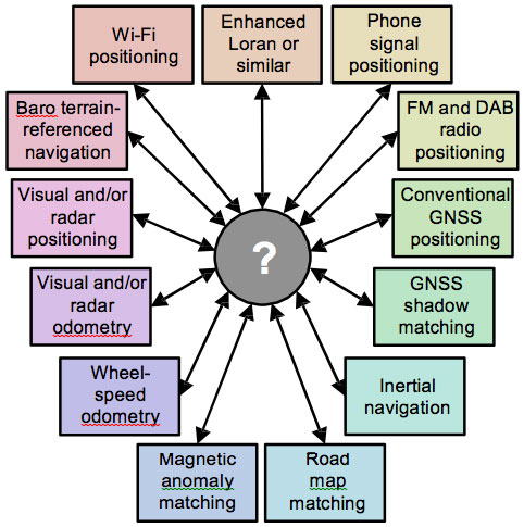
Although many new navigation and positioning methods have been developed in recent years, little has been done with all-encompassing vision to bring them together into a robust, reliable, and cost-effective integrated system. Almost all the solutions proposed — and I have conveyed many of them in the pages of GPS World, thanks to the expert engineers who designed and tested them — spring from the requirements of a particular situation, application, or industry sector. Their parameters are suitably specialized.
What’s been lacking so far is an over-architecture for the entire field. Paul Groves of University College London has outlined such a structure in an article that will appear in the September issue of the magazine: “Four Key Challenges to Multisensor PNT.” This material was first presented at the IEEE/ION Position Location and Navigation Symposium (PLANS) in Monterey, California in May of this year.
The magazine article will describe each challenge in turn. In each case, Groves explains the problem, proposes one or more solutions, and identifies the issues that must be resolved in order to implement those solutions. He also presents the results of some preliminary context-detection experiments and illustrates some of the problems using results from several UCL research projects. The discussion is illustrated with results from research into urban GNSS positioning, GNSS shadow matching, environmental feature matching, and context detection
The four challenges: complexity, context, ambiguity, and environmental data handling.
Complexity – How to find the necessary expertise to integrate a diverse range of technologies, how to combine technologies from different organizations that wish to protect their intellectual property, how to incorporate new technologies and methods without having to redesign the whole system and how to share development effort over a range of different applications.
Context – How to ensure that the navigation system configuration is optimized for the operating environment and host vehicle (or pedestrian) behavior when both are subject to change.
Ambiguity – How to handle multiple hypotheses, including measurements of non-unique environmental features, pattern-matching fixes where the measurements match the database at multiple locations, and uncertain signal properties, such as whether reception is direct or non-line-of-sight (NLOS).
Environmental Data Handling – How to gather, distribute, and store the information needed to identify signals and environmental features and define their points of origin or spatial variation.
As Groves relates in his article, many new positioning techniques have been investigated over the past fifteen years.
Wi-Fi positioning
Ultra-wideband (UWB) positioning
Positioning using phone signals
Positioning using television signals and other signals of opportunity (SOOP)
Bluetooth low energy positioning
Laser-based position fixing and dead
Pedestrian dead reckoning (PDR) using step detection
Pedestrian map matching Error! Reference source not found.
Magnetic anomaly matching
Activity-based map matching
GNSS shadow matching
There have also been improvements to existing technologies.
Hardware required for visual navigation
Micro-electro-mechanical systems (MEMS) technology
Cold-atom technology and nuclear magnetic resonance (NMR) gyros offering aviation-grade performance with compact sensors
Legacy radio navigation systems, such as Distance Measuring Equipment (DME) and Loran (in Europe and South Korea) are being modernized
Doppler positioning is being reintroduced using Iridium communication satellites
Finally, GNSS itself has been enhanced through multiple constellations in a continual state of upgrade and renewal, high-sensitivity receivers and network assistance, and augmentation by commercial pseudolite systems.
Maybe it’s time for a high-level perspective on all these adjoining jungles, if we want to find our way out of them.
Potential components of a car navigation system using commonly available equipment and other low-cost sensors.
First, Lockheed Martin began investigating options for its GPS III payload supply line last year. Then in June of this year, the U.S. Air Force opened a “sources sought” initiative for a production-ready GPS space vehicle, equipped with an alternate payload, for consideration alongside the Lockheed Martin-built GPS III vehicle. Grumman and Boeing have responded to the U.S. Air Force call. Now the U.S. Senate has jumped into the act, with a 2015 defense spending bill that directs the Air Force to allocate at least $20 million for work on a space-based “digital navigation instrument” as a possible alternative to the payload developed for the GPS III satellites.
The Senate Appropriations defense subcommittee stated that it “believes that early Air Force investment, when combined with industry investment, into the development of a digital navigation payload will significantly reduce cost and schedule risk for the future GPS constellation.” What exactly is meant by a “digital navigation payload” — as opposed to the current payload under construction — is unclear. The systems on earlier GPS satellites probably used some analog components. Even modern receivers have an analog front end before the analog-to-digital converter. Perhaps the Senate Appropriations subcommittee wants more digitization in the nav unit.
Disaggregation. Further, the committee “firmly believes that movement away from large satellites, where possible, will result in significant cost savings and reduce the schedule to deliver payloads into orbit.”
This idea calls for dispersing space capabilities away from large platforms and into smaller ones.It would require, at the very least, a new constellation architecture for GPS III, an as-yet unexplored concept.
Status. Lockheed Martin is under contract to deliver the first eight GPS III satellites, but the award for up to 22 further IIIs remains open. Difficulties with the payload for the first batch of satellites mean that although Lockheed has three space vehicles ready, it has no signal payload to put aboard them. Subcontractor Exelis is at work on that.
Lockheed Martin spokesperson Chip Eschenfelder has stated that “signal cross talk issues are resolved. The SV01 navigation payload forecast delivery to Lockheed Martin is fall 2014. Once the first navigation payload is delivered, we are into the production phase.”
General John E. Hyten
General Support. At June’s ION Joint Navigation Conference, General John E. Hyten, currently vice and soon to be commander of USAF Space Command, while evincing unqalified support for the system operators, did not address the GPS III manufacturing and supply issue. He confined his industry-related remarks to warning commercial PNT vendors and government program managers to cease placing commercial GPS receivers in critical government systems that support warfighters, government users, and critical national infrastructure.
He strongly advocated for Selective Availability Anti-Spoofing Modules and M-Code to help secure these critical systems against interference, jamming and spoofing, and urged manufacturers to build their devices in strict adherence to the U.S. government’s ICD process.
FCC Seeks Spectrum but Supports GPS
In a June 20 workshop on “GPS Protection and Receiver Performance,” the U.S. Federal Communications Commission (FCC) reiterated the need to safeguard critical infrastructure and public safety — two key uses of GPS.
Despite fears that the FCC would call for new GPS receiver standards, the meeting took a protective and conciliatory tone, even as the FCC continues to seek more frequencies for mobile broadband, citing the need “get more out of the radio spectrum.”
FCC Chairman Tom Wheeler stated, “Today is not about FCC-mandated receiver standards. Rather it is about the best way to protect GPS operations in the context of evolving technology and adjacent spectrum activities.”
The specter of adjacent spectrum use hovered through the day, fully appearing in LightSquared and administration presentations. Otherwise, scant mention was made of the 2012 notion that GPS receivers should be modified to stop alleged “peeking” into adjacent spectrum.
Panel discussions focused on GPS in critical infrastructure and public safety, with presentations by Qualcomm, Motorola, and AT&T. Speakers from T-Mobile, Spirent, Garmin, NovAtel, and John Deere covered GPS’s role in timing and the power grid, financial markets, telecommunication network, and precision agriculture. Paul Galyean of Deere said that “Certainty on the spectrum environment is needed. It’s difficult to design for the future without it.” If GPS receivers had to filter out cellular activity, this “might impact sensitivity, involve excessive size or cost, and might cause distortion of GPS measurements.”
Chris Hegarty, MITRE Corporation, gave a compelling argument for not overhauling receiver methodology: the extremely long lead times for commercial passenger aircraft. “Until 2022 every new Boeing and Airbus is going to fly off with $250,000 worth of navigation equipment that has three $50,000 GPS receivers and antennas and everything else, and they are going to want to use that for 20 to 25 years. So, you have a timing issue. Even if we all decided today that we wanted to do that, some communities simply aren’t going to be able to get it into place until we’re all dead.”
Power Loss Strikes Galileo Satellite
In-Orbit Validation Vehicle May Be Lost to Further Use
The disappearance of signals from Galileo GSAT0104, the fourth in-orbit (IOV) Galileo satellite, arose from a sudden, unexpected loss of power aboard the space vehicle. The exact cause is unknown, or at least unreported as of press time. Some have speculated that the cause could lie in a failure of components around the solid-state power amplifier, including the output multiplexer, cables, or antenna.
If such proves to be the case, ground operators may be powerless to repair the problem. The satellite would be a total loss.
The power outage flashed on May 27, shutting down the satellite’s E1 signal. The signal “re-established itself almost immediately. But as soon as it was back in service, the two other channels’ power dropped and did not recover. The full satellite then was shut down by ground teams,” reported correspondent Peter de Selding.
Looking for a Fix. European Space Agency (ESA) officials stated on July 3 that they would power-on the satellite again during the week of July 7–11 to continue an investigation into the problem, but there have been no subsequent reports. Investigation has been ongoing since the shutdown but has not identified a cause; officials state they have established that it is not related to the onboard atomic clocks.
The four IOV satellites currently aloft differ in both technology and manufacturer from the next phase of Galileo satellites to be launched. The GSAT0104 satellite now in silent orbit was built by Astrium. The newer, operational satellites are produced by OHB-System, following a different payload design. Two of the newer generation are at the Guyana spaceport awaiting a possible late August lift date.
Reporting History. The possibility of a satellite failure was first floated in the June 30 EAGER newsletter (European GNSS and Earth Observation Report), by contributing editor Tim Reynolds. He wrote:
“Has anyone heard anything from Galileo GSAT0104 recently? According to the European GNSS Service Centre, the fourth IOV satellite is ‘unavailable until further notice.’ The setting of unavailability may be due to in-orbit validation testing, as the website implies may be the case, but no further official statement has appeared, nor active user notifications (NAGUs) at http://www.gsc-europa.eu/system-status/user-notifications.”
Two days later, GPSWorld.com posted a follow-up story: “According to reports, the root cause of the outage is under investigation. Some unofficial sources have gone so far as to speculate that GSAT0104’s useful transmission life may be over.”
Then, on July 3, correspondent Peter de Selding (who also contributes to EAGER) reported in Space News, after questioning sources at ESA, that the trouble aboard the fourth IOV Galileo satellite arose from a sudden, unexpected loss of power, as stated in the first paragraph of this article.
Largest Fine in FCC History — $35M — for Chinese Jammer
The Federal Communications Commission (FCC) plans to issue the largest fine in its history against C.T.S. Technology Co., Limited, a Chinese electronics manufacturer and online retailer, for allegedly marketing 285 models of signal jamming devices to U.S. consumers for more than two years.
The FCC applied the maximum fine allowed to each jammer model allegedly marketed by C.T.S., resulting in a planned fine of $34,912,500.
“All companies, whether domestic or foreign, are banned from marketing illegal jammers in the U.S.,” said Travis LeBlanc, acting chief of the Enforcement Bureau. “Signal jammers present a direct danger to public safety, potentially blocking the communications of first responders. Operating a jammer is also illegal, and consumers who do so face significant civil and criminal penalties.”
C.T.S. operates a website that markets consumer electronics to individuals in the United States, where it allegedly misled U.S. consumers by falsely claiming that certain signal jammers were approved by the FCC. In fact, the use of such devices by U.S. consumers is illegal under any circumstance. C.T.S. also sold 10 high-powered signal jammers to undercover FCC personnel.
The FCC also is ordering C.T.S. to cease marketing illegal signal jammers to U.S. consumers and provide information to the FCC about any persons and entities in the United Sates that purchased its devices.
Signal jammers are radio frequency transmitters that intentionally block, jam, or interfere with authorized communications, such as cellphone calls, GPS systems, Wi-Fi networks, and first responder communications. It is a violation of federal law to market, sell, import, or use a signal jammer in the United States and its territories, except in very limited circumstances involving federal law enforcement.
The FCC asks people to report the sale or use of an illegal jammer by contacting the FCC Enforcement Bureau through the FCC online complaint portal, or by calling 1-888-CALL-FCC (or 1-888-225-5322). To voluntarily relinquish a signal jammer, e-mail [email protected]. Additional information, including a Consumer Alert and Enforcement Advisory to retailers, is available at www.fcc.gov/jammers.
Getmapping has posted strong growth for the 2013 financial year. The recently released financial results showed Getmapping post record turnover and profits on the back of strong growth in both the United Kingdom and African markets.
Getmapping is a public limited company, and terms itself the UK’s leading supplier of aerial photography, mapping products and data hosting solutions.
Group turnover was up 34% overall from £3.5m in 2012 to £4.7m in 2013, with the contribution from African operations up 86% on the previous year. Getmapping’s strong performance has also been reflected in its share price which has tripled in the last three years as interest in the company from investors grows, the company said.
Getmapping has been working hard to extend both the range of products and services that it can offer as well as its global reach. In 2013, for example, Getmapping established a new LiDAR division in Centurion, South Africa, which has enabled it to extend its range of services and provide them across a wider geographical area.
While the UK remains a challenging market, Getmapping continues to work hard to retain its strong position. As an example, Getmapping, together with Bluesky, was recently awarded a multi-million pound contract for the supply of geographic data to Central Government organizations. The contract, awarded by the Department for Environment, Food and Rural Affairs (DEFRA), covers high resolution aerial photography, detailed 3D height models and colour infrared imagery for the whole of England, Wales and Scotland. Under the new Aerial Photography for Great Britain (APGB) contract, Getmapping and Bluesky can also provide training, consultancy and workshops to contract members.
“Getmapping delivered strong growth in 2013 across all of our core business streams. The company has invested heavily in new sensor and processing technology and the investment is already delivering strong results which we expect to carry through 2014 and beyond,” said Dave Horner, managing director of Getmapping. “The recent DEFRA contract and winning the aerial photography contract for the Scottish government in 2013 has reinforced our position as the leading supplier of aerial photography services in the UK. The financial results are an endorsement of our strategy, but we won’t be resting on our laurels and aim to continue to improve our performance in 2014 and beyond.”
Supergeo is providing free online GIS web courses to support real-world case application of GIS technologies. The courses will introduce GIS software on various platforms, from basic to advanced. Through the courses, users can gain geospatial knowledge and a comprehensive understanding of SuperGIS software operations and applications.
Supergeo is dedicated to providing total GIS solutions for worldwide users and enabling personnel in diverse domains to apply spatial technologies on various platforms, including desktop, server, mobile devices, and web services. The courses will cover:
Desktop GIS: the use and application of SuperGIS Desktop and extensions, analysis functions in SuperGIS Toolkit, and image data processing.
Server GIS: Publishing map services and customizing JavaScript map website with SuperGIS Server, the applications of Mobile SDK, and so on.
Mobile GIS: Collecting spatial data with smart devices, recording GPS tracklog, viewing waypoints with Augmented Reality in SuperSurv (for iOS), and more.
 Esri’s updated