Blog

  • Jacobson Chronicles Evolution of GPS in New Book

    Jacobson Chronicles Evolution of GPS in New Book

    Flying-for-GPS-JacobsonFlying for GPS, a chronicle of Len Jacobson’s role in the development and promotion of the Global Positioning System, has just been published.

    The book spans a 50-year career, during which Jacobson flew 2½ million miles as a missionary for GPS and as a developer of user equipment. He kept an extensive log of all of his flights, and it enabled him to recreate in his book much of what happened with GPS during his career, and his impressions of why these events occurred.

    Flying for GPS covers the user-equipment evolution from expensive, complex and voluminous military sets to today’s low-cost chips buried in our cell phones. It traces a system designed primarily for military and civilian aircraft, ships, and land vehicles to an essential utility of everyday life, enabling new businesses, more safety, and the ability to track everything that moves. It is also a memoir written for the GPS community.

    An excerpt of Flying for GPS will appear in the July issue of GPS World magazine. In 2013, Jacobson wrote about his early GPS experiences for the magazine.

    Flying for GPS draws from Jacobson’s GPS experience while working for Hughes Aircraft, Magnavox, Interstate Electronics (IEC), and his own company, Global Systems and Marketing, Inc.

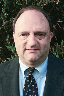
    Len Jacobson.
    Len Jacobson.

    He worked on various assignments from most of the major GPS companies and several small businesses that were trying to find a position in the GPS market. He also participated as an expert witness in many legal cases involving GPS, from patent disputes to accident reconstruction to parolee tracking.

    In parallel with the evolution of GPS, the book chronicles the changes in commercial air travel as Jacobson experienced it, from flying on a PanAm 707 in 1963 to an Air France A380 today. The book is available now from www.xlibris.com, Amazon, Barnes & Noble, and soon from ebook outlets.

    Len Jacobson is a retired GPS consultant, having worked in the field since 1968. He is still active in the Institute of Navigation, for which he served as western regional vice president twice and held leadership roles in several of its conferences. He lives in Long Beach, California. Visit his site at www.lenjacobson.com.

  • Leica Releases Viva GNSS Unlimited Series

    Leica Releases Viva GNSS Unlimited Series

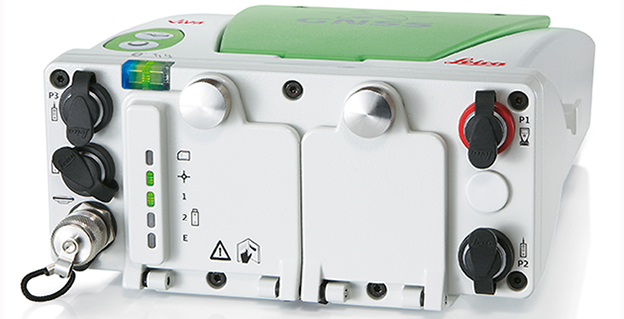
    Leica_Viva_GS100-W
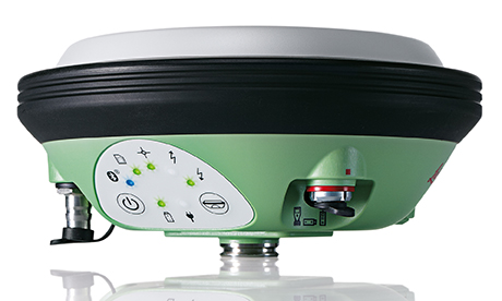
    Leica Viva GS100

    The Leica Viva GNSS Unlimited Series, available in August, will allow customers to make a safe investment with future-proof GNSS receivers and smart antennas, Leica Geosystems said in announcing the new series. With a flexible design, the Viva GNSS sensors can be upgraded for maximum performance whenever needed.

    The Leica Viva GNSS range fully supports the Chinese BeiDou navigation system. It can even provide BeiDou-only and GLONASS-only high-precision positioning. The unlimited series includes a future upgrade to a GNSS board with more than 500 channels and will serve users’ needs beyond 2020, the company said. Outages of real-time kinematic (RTK) communication links are bridged for up to 10 minutes with SmartLink to increase centimeter position availability in areas where RTK communications links are unstable.

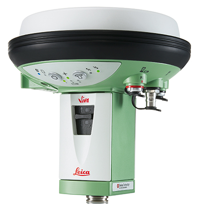
    Leica Viva GS15
    Leica Viva GS15

    The Leica Viva GNSS Unlimited Series can be upgraded to the full range of GNSS signals. The sensors’ future-proof design is equipped for GNSS modernization, providing users with confidence in their investment. The series embraces the future-proof concept by including an upgrade to a GNSS board with more than 500 channels. To fully guarantee future proof GNSS, board exchanges are inevitable because any likely modifications in GNSS signals require a new GNSS ASIC (Application Specific Integrated Circuit).

    Leica SmartTrack technology guarantees accurate signal tracking, while SmartCheck technology evaluates and verifies RTK measurements to ensure reliable results. Both SmartTrack and SmartCheck technologies have been extended to support the BeiDou GNSS. BeiDou reached full operational regional capability in 2012 and has a total of 14 satellites. Leica Viva GNSS also supports features like BeiDou-only and GLONASS-only positioning to accommodate governmental regulations.

    In addition, Leica Geosystems now offers SmartLink, a correction service delivered via satellite for uninterrupted centimeter positioning in areas where RTK communication links are unstable.

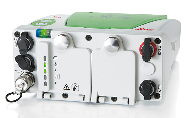
    Leica Viva GS14
    Leica Viva GS14

    All Leica Viva GNSS products exceed the toughest environmental specifications, going beyond industrial standards such as IP68. This ensures flawless performance even in the most challenging environments. Applications for the range include construction and field surveying, mining, seismic work in dense forest, desert or mountains, as well as demanding work in extreme heat at 65°C (149 °F) or at extreme latitudes at -30°C (-22 °F). Premium precision and attention to detail ensure that the Leica Viva GNSS products can be trusted throughout the complete product lifetime.

    Leica Viva offers a complete range of unlimited GNSS and TPS solutions made with Swiss precision, combining the highest accuracy with maximum versatility and optimized data flow. Leica Viva solutions include Active Customer Care (ACC) with an expansive organization of knowledgeable professionals to provide valuable support, training and service whenever needed. Combined with innovative services such as online support in the field with Leica Active Assist and an instant data exchange between field and office with Leica Exchange, Leica Viva enables continuous productivity.


    Webinar on Multi-GNSS OEM

    Thursday, June 5
    10 a.m. PT / 1 p.m. ET / 5 p.m. GMT

    GPS World’s upcoming webinar features an expert panel with informed viewpoints from GNSS high-precision and mass-market manufacturing, signal simulation, and alternative PNT providers. Registration is free.

  • Intuicom Announces Next-Generation RTK Bridge-X with Wi-Fi

    Intuicom Announces Next-Generation RTK Bridge-X with Wi-Fi

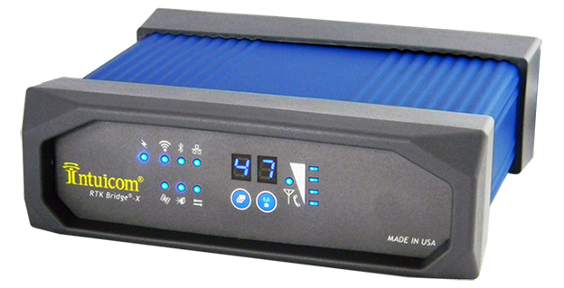
    Intuicom RTK Bridge-X.
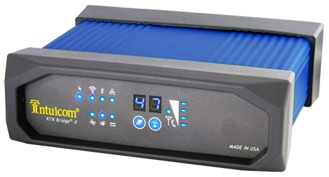
    Intuicom RTK Bridge-X.

    Intuicom, Inc., a wireless data solutions provider for the survey, machine control and precision agriculture industries, has added to its line of RTK Bridge solutions with the Intuicom RTK Bridge-X.

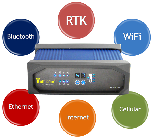
    Along with providing reliable access to RTK corrections, the RTK Bridge-X features a Wi-Fi hotspot. Users can connect other Wi-Fi devices such as laptops, tablets and smartphones and access the Internet via the RTK Bridge-X’s cellular connection. Also new with the RTK Bridge-X is cable-free configuration. Configuration can now be accomplished through a wireless connection using any web browser.

    Users can then access email, send files, and perform other Internet-based tasks using the connection provided by the RTK Bridge-X. With new Remote Access, the RTK Bridge-X can be reached over the Internet from anywhere.

    The RTK Bridge-X also comes with internal GPS. Users can choose between an internal license-free 900-MHz radio, industry-standard UHF radio, or no radio.

    Other improvements include a real-time cellular signal strength indicator on the re-designed front panel, as well as an Ethernet port that can be used for configuration or Internet connectivity. A numerical LED display now shows which of the four configurable profiles is active as well as which radio channel is selected. Bluetooth connections are also supported.

    Like all Intuicom Bridge Products, The RTK Bridge-X is designed for easy setup and operation and is compatible with all major cellular carriers and equipment manufacturers including Leica Geosystems, Trimble, and others.

    RTK-Bridge-X-and-buttons-W

  • Trimble Adds Agronomic Service to Connected Farm Solution

    Trimble is offering a new agronomic service that is part of its Connected Farm solution. The new service, Soil Information System (SIS), provides farmers and their trusted advisors with in-depth 3-D soil data they can use to make more informed decisions about their crop production goals.

    The SIS data is accessed through Connected Farm and can be used with Trimble’s Farm Works farm management software or other GIS platforms. Connected Farm enables better decision making by providing one central location for accessing key information impacting farm operations such as rainfall totals, weather forecasts, commodity tracking, planting coverage, yield mapping, fleet management, and irrigation monitoring and control, Trimble said.

    The SIS 3D soil mapping technology uses advanced sensors along with intelligent targeting and geoprocessing algorithms to produce high-resolution, accurate soil and topographic information. By providing a greater understanding of the physical and chemical characterization of the soil, including how inputs move through the soil, SIS enables farmers to initiate more effective solutions to resolve the unique challenges of each area of their fields. The SIS solution outputs precise, multi-layer soil models that are more comprehensive than traditional methods used in the industry today. Some examples of map types include: root zone depth, soil texture, plant available water, compaction depth, macro and micro-nutrient levels, soil nutrient holding capacity, and salt and toxicity concentrations.

    By analyzing soil variability and patterns prior to sampling — and by using its industry-exclusive data acquisition and analysis software — SIS provides targeted recommendations on the best locations where soil samples should be taken. In some cases this reduces the number of samples required to provide high-quality information by as much as 60 percent over traditional sampling methods. As a result, the solution enables agronomists to be more efficient with in-field data collection, providing valuable time and operating cost savings.

    “By adding the Soil Information System solution to Connected Farm, Trimble is providing farmers and their agronomists with critical soil information they can use to improve crop production and benefit the bottom line,” said Levi Kettle, Connected Farm business area director of Trimble’s Agriculture Division. “For example, knowing the soil’s plant available water capacity can aid in irrigation layout, scheduling, moisture sensor targeting, root stock selection and many other management decisions.”

    “Variability in yield and quality are due primarily to non-uniform soils being managed as uniform soils. In the past, our inability to identify the components of this soil variability prevented us from achieving greater crop uniformity and better economic returns,” said Robert Wample, Ph.D., a plant physiologist and owner of Edgeknoll Consulting, an SIS service provider. “SIS allows us to take a proactive approach to overcoming soil variability, and when combined with geo-referenced variability in crop yield and quality, the effectiveness of this approach is enhanced even more resulting in an ‘agricultural forensics’ approach to precision agriculture.”

    The SIS solution is available in several service levels depending on the accuracy and resolution required for the particular crop type and the grower’s production goals.

  • Jack Dangermond of Esri Pledges $1B of Mapping Software to Schools

    Jack Dangermond, founder and president of Esri, has announced that Esri will make its advanced mapping software ArcGIS available for free to K-12 schools across the country, reports FORBES. Through the program, students will have access to the same cloud-based GIS technology used by governments and businesses to map and analyze data. The program is set to benefit more than 100,000 schools, with each ArcGIS online account worth about $10,000, adding up to a total potential value exceeding $1 billion, according to Esri.

    “This is not a new endeavor by us. We have been supporting GIS in schools for more than 25 years,” Dangermond told FORBES. “Bringing GIS into schools gets the kids very excited and indirectly teaches them different components of STEM education. That’s been illustrated at school after school.”

    The idea began when Dangermond met with President Obama a few months ago to discuss how Esri can contribute to the ConnectED Initiative, a program by the White House to help strengthen STEM education for K-12 students. “I asked myself: ‘What’s the biggest idea that we can go for?’” Dangermond recalled. As soon as he proposed that Esri would offer its software for free for every K-12 school in America, the president was immediately on board. “We thought this is a way to scale it up and bring GIS education to schools in the whole country,” Dangermond said.

    Esri previously experimented with the initiative on a smaller scale in different states. In Detroit, students used the company’s software to identify environmental issues and come up with plans to fix them. Students also have used ArcGIS to map health issues in Los Angeles and use demographic data to get Walmart products delivered to returning veterans.

  • Forecast Looks at Intelligent Transport Systems

    A new report from Research and Markets Ltd. forecasts intelligent transport systems, with a focus on highways. The report is titled “Intelligent Transport Systems Market by Component, Application, System (ATMS, ATIS, ITS- Enabled Transportation, Pricing System, APTS and CVO), and Geography (Americas, Europe, APAC, ROW) Analysis and Forecast to 2014-2020.”

    Countries around the globe have started to employ a new set of technologies and approaches to meet the challenges that are surfacing in transportation. The applications of the Intelligent Transport System (ITS) are cater to today’s traffic challenges. ITS improves operational benefits of the transportation system by reducing delays, which develops the roadside infrastructure and allows the traffic to flow smoothly, the report says.

    In developed countries such as the U.S., Germany, and France, ITS are already installed on a large number of highways. In developing countries such as India, China, Indonesia, the installation of ITS is increasing.

    The ITS market covered in the report includes only the roadway transportation, as the rate of developments and improvements in the sector of roadway transportation is high. This ITS market research report covers Advanced Traveler Information System, Advanced Traffic Management System, ITS-Enabled Transportation Pricing System, Advanced Public Transportation System, and Commercial Vehicle Operation.

    It also covers applications, including: fleet management and asset monitoring, traffic monitoring, collision avoidance system, traffic signal control system, variable traffic message signs, parking availability system, and traffic enforcement cameras. It also covers these components: PCB, Sensors, Surveillance Camera, Software License, Communication Networks, Monitoring and Detection System. Geographically, the report is segmented into North America, Europe, Asia-Pacific, and Rest of the World. These segments are further segmented into the major countries.

    The report forecasts the growth from 2014 to 2020, along with market size, list of leading players, and the latest technology adopted M&A’s, and JV’s of key players.

    • Intelligent transportation market statistics with detailed classifications – market size, forecasts, and industry roadmap of ITS market, impact analysis of the market dynamics with factors currently driving and restraining the growth of the ITS market, along with their impact in the short, medium, and long term landscapes and Porter’s analysis of the market.
    • Key burning issues and opportunities with respect to ITS market.
    • Analysis of various ITS components, systems and applications of the market.
    • Identification of segments with high growth potential and key trends shaping and influencing the market.
    • Extensive segmentation, analysis, and forecast of the major geographical markets to give an overall view of the market – growth rates and trends of markets in the major revenue contributing countries such as the U.S., the UK, Germany, China, India, and Japan.
    • Competitive intelligence from the company profiles, developments, upcoming trends and technologies, revenue-growth strategies, and industry activities.
    • The governments of developing countries like Thailand, India, China, Malaysia, and so on, are revamping their infrastructures to develop road transportation.

    Companies mentioned:

    • Denso Corporation
    • EFKON AG
    • Garmin International, Inc.
    • Kapsch Trafficcom AG
    • Nuance Communications, Inc.
    • Q-Free ASA
    • Savari Inc.
    • TomTom NV
    • Thales Group
    • Transcore Inc.

    Learn more at the Research and Markets website.


  • Leica Offers Next-Generation Mobile Mapping Platform, Pegasus:Two

    Leica Offers Next-Generation Mobile Mapping Platform, Pegasus:Two

    PegasusTwo_application-W
    photo: Leica

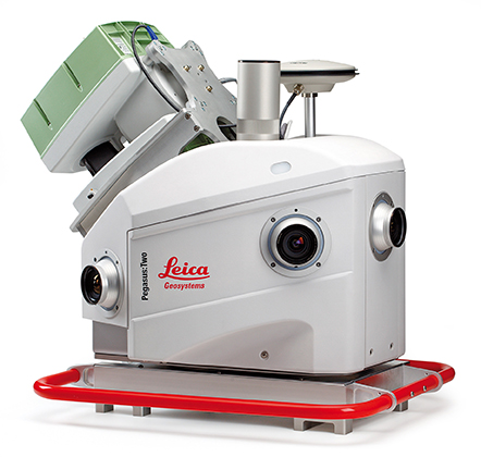
    Leica Geosystems has introduced its next generation vehicle-independent mobile mapping platform, the Pegasus:Two. By calibrating imagery and LiDAR point cloud data, the Pegasus:Two delivers highly accurate and economical geospatial data in a 360° spherical view while providing two methods for extracting data — either through LiDAR or via photogrammetry.

    With its enhanced sensor platform using six horizontal cameras, plus an optional rear camera and a skyward view camera, a single high-speed LiDAR sensor, and an external output for an additional sensor, the Pegasus:Two enables unlimited mobile mapping applications, from pavement analysis to geo-referencing railways systems, now possible within the same platform, the company said.

    From hardware to post-processing, Pegasus:Two allows economic data collection by balancing the largest pixel to sensor ratio on the market (5.5 x 5.5 µm), delivering extremely high image resolution, in a 4-MB camera and using a single low-noise, high-speed profiler. Users can download data via Wi-Fi or wired Ethernet, or even faster by using the latest USB3 interface, by means of a multi-core, industrial PC with 1-TB storage and a solid state drive, enabling longer missions. An optional rotation mount, designed specifically for the Leica ScanStation P20, also makes mounting the terrestrial scanner upside down or right side up while also enabling left or right rotation.

    The Pegasus:Two in its new streamlined housing with aerodynamic design.
    The Pegasus:Two in its new streamlined housing with aerodynamic design.

    Expanding on the success of Leica Geosystems’ mobile mapping software, the latest software now offers semi-automatic object extraction features, which enable easy-to-use two-click GIS metadata extraction or calculation of distances on-the-fly directly into ArcGIS for Desktop software.

    Leica Geosystems also introduces an external timing output and trigger signal for use with a variety of additional sensors, from a thermal camera, to ground penetrating radar, sonar, or even a pollution monitor. The External Trigger feature synchronizes time stamping and coordinates user data with one simple click, making 3D mobile mapping very user-friendly.

    Urban canyons. Equipped with the NovAtel’s ProPak6 high-precision receiver for the most demanding city or rugged environments, the Pegasus:Two offers users a truly global system. It is a future-proof investment that tracks signals of all available constellations, GPS, GLONASS, Galileo and BeiDou as well as L-band, SBAS, and QZSS band coverage to ensure the best signal even when moving through urban canyons. The system provides a low noise, 200hz Inertial Measurement Unit for tracking the vehicle path thereby ensuring data is positioned accurately.

    Aerodynamic design. The Leica Pegasus:Two mobile mapping system now comes with a new streamlined and compact look and continues to fit in only two travel cases. A convenient handle surrounding the unit enables easy mounting on and off your vehicles. The Pegasus:Two is a vehicle-independent system with a rechargeable 11 hour battery, and can be used on any moving platform.

    “The Leica Pegasus:Two platform is a unique complete solution,” said Stuart Woods, vice president for Leica Geosystems Geospatial Division. “By providing software and hardware designed to seamlessly work together, users not only receive the latest in mobile mapping technology but also optimal performance and faster workflows. By keeping the platform vehicle independent and adding new sensor options, we encourage our customers to find new ways, to try out different sensors, new revenue models, and new places to measure. ”

    Along with the Pegasus:Two, the advanced prototype, Pegasus:T2, a trolley based mobile system weighing less than 20 kilograms will also be on display at the HxGN LIVE 2014 Conference in Las Vegas.

  • GNSS Manufacturing and Purchase Decisions Outlined in Thursday’s Webinar

    GNSS Manufacturing and Purchase Decisions Outlined in Thursday’s Webinar

    The two GLONASS stumbles in May prompted industry leaders to again promote multi-GNSS user equipment and the development of of reliable back-up/redundant positioning, navigation, and timing (PNT) systems to cope with potential drop-outs of space-based services due to jamming, unintentional interference, spoofing, or other disruptions. But neither multi-GNSS nor back-up/alternative PNT fully exists at this time, effectively for all users. When will reliable, robust, consistent, and continuous positioning become a reality?

    The two concepts of multi-GNSS, at both high-precision and mass-market levels, and alternative, non-space-based PNT, will come into widespread availability sometime over the next five to 15 years — that much can be assumed with a degree of confidence. But more precision as to when is completely lacking, and the uncertainty affects product design and life-cycles, and user decisions on equipment purchase.

    Should manufacturers and users rely on whatever technology we currently possess until the perfect system comes available, or should they continuously upgrade at each iterative step along the way?

    I will moderate an expert panel discussion this week, featuring informed viewpoints from GNSS high-precision and mass-market manufacturing, signal simulation, and alternative PNT providers. Visit env-gpsworld-integration.kinsta.cloud/webinars to register for this free, insightful presentation. The webinar takes place Thursday, June 5, at 10 a.m. Pacific time / 1 p.m. Eastern U.S. Time / 5 p.m. Greenwich Mean Time.

    Speakers

    Host/Moderator:

    Alan Cameron

    Alan Cameron, group publisher, GPS World and Geospatial Solutions

    Cameron was recently promoted to publisher of two North Coast Media brands. He was previously editor-in-chief and publisher of GPS World magazine, where he has worked since 2000. He also writes the monthly GNSS System Design & Test e-mail newsletter and the Wide Awake blog, both of which can be found on this site.

    s_aultSteve Ault, Product Manager, NavCom Technologies

    Steve Ault has 13 years of experience in the GNSS market, having previously worked for Magnavox and Leica in the 1990s before joining NavCom in late 2006. He has also worked on a wide variety of radio-based technologies dating back to the early 1980s, which include cellular phone infrastructure, VSAT systems, and military command and control communications systems. Steve holds a B.S. in Business Management and is a six-year veteran out of the U.S. Air Force. He is currently the product manager for NavCom Technologies and oversees all of NavCom’s marketing activities.

    jpottleJohn Pottle, Fellow, Institute of Engineering Technology and Royal Institute of Navigation

    John Pottle is marketing director at Spirent’s Positioning Technology division, based in the UK. Spirent leads the world in enabling its customers to build robust, resilient, positioning, navigation and critical infrastructure systems. Before joining Spirent, Mr. Pottle spent 12 years in satellite communications and broadcasting, first with BT International in London and later with Intelsat in the USA. Mr. Pottle holds a Bachelor of Science degree in Communication Engineering and an MBA. He is a Fellow of the Institution of Engineering Technology and a Fellow of the Royal Institute of Navigation.

    p_mattosPhilip Mattos is an R&D scientist for several GNSS companies.

    Philip Mattos was the chief architect of STMicroelectronics GPS/GNSS chipsets since a software receiver in the 1980s and dedicated silicon from the early ’90s, adding Galileo, GLONASS and BeiDou. He is now a consultant to chip manufacturers and agencies. He holds Masters degrees in electrical engineering from Cambridge and telecomms and computer science from the University of Essex, was awarded an external Ph.D. on his GPS work from Bristol University, where he is a Research Fellow, and is a visiting professor at University of Westminster. He has contributed to the design of the Galileo system for many years, and continues to advise on its future evolution.

    p_benshoofPaul Benshoof, Global Business Development Manager, Locata Corporation

    Paul Benshoof is currently the Global Business Development Manager of Locata Corporation, a company that has invented terrestrial positioning networks which function as local ground-based replicas of GPS, fully capable of providing accurate PNT in user-defined regions. He spent the last 22 years working in GPS with duties that include procuring military GPS receivers, developing assets to support navigation warfare advanced technology demonstrations, supervising international test programs for NATO and allied forces, coordinating guidance and navigation test & evaluation infrastructure improvement programs, and directing GPS Test Center of Expertise.

    Register for the webinar today.

  • Hexagon Acquires iLab for Smart Agriculture

    Hexagon AB, a global provider of design, measurement and visualization technologies, has acquired iLab Sistemas, a provider of planning and optimization solutions for the agro business sector, with special focus in the sugar and ethanol industries. iLab will, together with Arvus and Leica Agriculture, form the backbone of Hexagon’s Smart Agriculture Solution.

    Headquartered in Ribeirão Preto, Brazil, iLab takes advantage of extensive know-how and various techniques to deploy highly parameterized solutions that address complex problems related to agricultural processes and production. They include linear programming, operations research, genetic algorithms, constraint-based programming, neural networks, statistics and advanced mathematics. ILab’s offerings include software optimization tools for every stage of crop growth — from planting, harvesting and logistics planning to area and asset management, scenario comparisons, and cost and budget forecasting — permitting value-added decision analysis and process automation.

    “Together with its established software suite of end-to-end planning optimization solutions for sugarcane mills, iLab’s strong market footprint in the sugarcane industry will support the further development of the Smart Agriculture solution from Hexagon Solutions,” said Hexagon President and CEO Ola Rollén. “Additionally, iLab’s offerings complement the product portfolios of Hexagon brands Leica Geosystems, Sisgraph and Devex in areas such as fleet management, precision agriculture, automation platforms and control room technologies.”

    ILab will be fully consolidated as of today. The acquisition has no significant impact on Hexagon’s earnings, Hexagon AB said.

  • AT&T Ready For Hurricane Season as Part of Disaster Recovery Program

    AT&T’s Network Disaster Recovery (NDR) program, as the first private company certified by the Department of Homeland Security for private-company voluntary disaster preparedness, is committed to maintaining and restoring the AT&T global network when natural disasters strike, the company said.

    Despite predictions, no one is certain when the next tropical storm or hurricane will ravage the coastline. With $600 million invested in the NDR program, AT&T’s arsenal of equipment includes more than 320 technology and equipment trailers that can be quickly deployed, making it one of the nation’s largest and most advanced disaster programs.

    “Staying connected during severe weather events is critically important to consumers, businesses and our emergency management officials,” said Sonia Perez, president, AT&T Louisiana. “That’s why AT&T invests a tremendous amount of resources in our network reliability and disaster response capabilities.”

    The Network Disaster Recovery team works closely with other AT&T response teams, local AT&T network personnel, regional Emergency Operations Centers and Local Response Centers to fortify network facilities and equipment, and stage technicians and resources near the storm impact area. In the event of damage, teams are poised to restore and maintain service until permanent repairs can be made.

    AT&T also conducts readiness drills and simulations throughout the year to ensure its networks are prepared and its personnel are ready to respond at a moment’s notice. Since its inception in 1991, the NDR has responded to more than 20 catastrophes across the U.S.

    Response equipment readied in the wake of an event includes:

    • Mobile cell sites and mobile command centers
    • Emergency communications vehicles
    • A self-sufficient base camp, complete with sleeping tents, bathrooms, kitchen, laundry facilities, on-site nurse and meals ready to eat (MREs)
    • Hazmat equipment and supplies
    • Technology and support trailers to provide infrastructure support and mobile heating ventilation and air conditioning
    • Internal and external resources for initial assessment and recovery efforts.

    Consumers and businesses also should have a plan in place. When preparing for an evacuation or shelter-in-place, remember these tips:

    • Keep your wireless phone batteries charged at all times. In case of a power outage, have alternate means of charging your phone available, such as an extra battery, car charger or device-charging accessory. Sales tax holidays are a great time to stock up on cell phone accessories for your household.
    • Keep your wireless phone dry. The biggest threat to your device during a hurricane is water, so keep your equipment safe from the elements by storing it in a baggie or some other type of protective covering, such as an Otterbox phone cover.
    • Have a family communication plan in place. Designate someone out of the area as a central contact, and make certain that all family members know who to contact if they get separated. Most importantly, practice your emergency plan in advance.
    • Forward your home number to your wireless number in the event of an evacuation. Because call forwarding is based out of the telephone central office, you will get incoming calls from your landline phone even if your local telephone service is disrupted at your home. In the unlikely event that the central office is not operational, services such as Voicemail, Call Forwarding, Remote Access call forwarding and call forwarding busy line/don’t answer may be useful.
    • Track the storm and access weather information on your wireless device. Many homes lose power during severe weather. If you have a working wireless device that provides access to the Internet, you can watch weather reports through services like AT&T U-verse Live TV or keep updated with local radar and severe weather alerts through My-Cast Weather, if you subscribe to those services.
    • Take advantage of location-based mapping technology. Services such as AT&T Navigator and AT&T FamilyMap can help you seek evacuation routes or avoid traffic congestion from downed trees or power lines, as well as track a family member’s wireless device in case you get separated.

    Keeping the lines open for emergencies

    During evacuations, the storm event and its aftermath, network resources will be taxed. To help ensure that emergency personnel have open lines, keep these tips in mind:

    • Text messaging. During an emergency situation, text messages may go through more quickly than voice calls because they require fewer network resources. All of AT&T’s wireless devices are text messaging capable. Depending on your text or data plan, additional charges may apply.
    • Be prepared for high call volume. During an emergency, many people are trying to use their phones at the same time. The increased calling volume may create network congestion, leading to “fast busy” signals on your wireless phone or a slow dial tone on your landline phone. If this happens, hang up, wait several seconds and then try the call again. This allows your original call data to clear the network before you try again.
    • Keep non-emergency calls to a minimum, and limit your calls to the most important ones. If there is severe weather, chances are many people will be attempting to place calls to loved ones, friends and business associates.

    Small Business Tips:

    • Set up a call-forwarding service to a predetermined backup location. Set up a single or multiple hotline number(s) for employees, employees’ families, customers and partners, as appropriate, to call so that all parties know about the business situation and emergency plan.
    • Back up data to the Cloud. Routinely back up files to an off-site location. Services such as Mobile Workplace are a suggested solution for small businesses.
    • Outline detailed plans for evacuation and shelter-in-place plans. Practice these plans (employee training, etc.). Establish a backup location for your business and meeting place for all employees.
    • Assemble a crisis-management team and coordinate efforts with neighboring businesses and building management. Be aware that disasters affecting your suppliers also affect your business. Outline a plan for supply chain continuity for business essentials.
    • Consider a back-up cellular network. Services like AT&T Remote Mobility Zone, allows organizations to protect their critical communications by installing small cell sites at the businesses’ locations. If a disaster disables primary communications networks, the back-up cellular network can help keep your company connected.

    Additional information and tips for disaster preparedness can be found at www.att.com/vitalconnections.

  • Lehmann Aviation Tests LA300 Drone with Cameras

    Lehmann-Aviation-drone-0

    In 2013, Lehmann Aviation launched the LA300 — a fully automatic personal drone working with Nokia Lumia 1020 and Windows 8 Tablet and designed for mapping and DEM.

    Flight tests in May have proven compatibility of the GoPro Hero3+ camera, in addition to Nokia Lumia 1020 41-Mp camera, with the LA300 for orthomosaics and digital elevation models (DEM), which makes this drone the an affordable and easy-to-use professional rugged solution for mapping and surveying, Lehmann Aviation said.

    Lehmann-Aviation-droneLA300 is a fully automatic professional UAV designed for accurate mapping and surveying. To get the geo-referenced orthomosaics or DEM, the user needs to take three simple steps (watch the video below):

    Step 1: Download the free Lehmann Aviation software — Operation Center — to any Windows 8 Tablet, Windows Phone 8, or PC.
    Step 2: Make the flight path by drawing on a touchscreen Windows 8 device the area of interest (on the map) and entering the waypoints, after which the software will automatically generate the mission.
    Step 3: Transmit the data to the drone by Wi-Fi, launch it by hand, and wait until the aerial robot returns to any chosen point with HD images or video on the SD card.
    Step 4: Use Operation Center to geotag each image after the flight, with LAT/LONG/ALT/YAW/PITCH/ROLL information.

    The pictures then can be processed in any popular orthomosaic/DEM software to generate professional orthomosaics and 3D models.

    Lehmann-Aviation-drone-2The drone flies at a range of up to 15 km, at speeds of 20-80 km/h. It can be flown in harsh environments, between -25 °C up to +60 °C (-13 °F up to 140 °F), with winds up to 35 km/h (20kt). The LA300 weights 950 grams (including Nokia Lumia 1020 or GoPro Hero3+ camera), with a wingspan of 92 cm and the length of 45 cm. The drone is launched by hand and lands in a few meters of space.

    All Lehmann Aviation drones come with one-year warranty and can be regularly upgraded to newer versions.

  • Fanbeam Laser Radar Delivers Dynamic Positioning to Offshore Vessels

    Seajacks_and_Fanbeam-W

    The new Fanbeam laser radar sensor from Renishaw’s spatial measurement division provides repetitive, high-accuracy dynamic positioning (DP) to offshore support vessels (OSV) and other marine structures.

    This next-generation system adds greater performance and stability through new control software that increases reliability of its single-target tracking capability, and allows multiple operator stations for situations where control needs to be transferred between bridge personnel. The new software’s advanced target tracking and modeling prevent spurious targets from causing a drive off, while the intelligent clutter rejection capability provides clearer signals for a better understanding of the operational environment. A training package with a fully featured, realistic simulator is also included.

    The Fanbeam system uses position data to automatically hold vessels on station, and is typically the primary position reference during critical short-range operations, such as cargo container lifts from platform supply vessels. The system provides collision avoidance, gangway monitoring and docking assistance on vessels operating in crew supply, anchor handling tug supply, construction support, dive support, dredging and rock dumping capacities. Other applications include seismic source positioning for geophysical exploration vessels and positioning of mine detection equipment.

    Fanbeam laser radar sensor.
    Fanbeam laser radar sensor.

    The system uses a laser sensor with a unique vertically “fanned” output, allowing returns to be observed from passive retro-reflective targets despite relative movement of the vessel. Accurate to 20 cm, the laser rotates horizontally in both directions via motorized base, and can be tilted ± 15˚ in the vertical plane using a built-in Autotilt mechanism with servo-driven gearbox. The motorized yoke has a software-selectable scanning speed up to 50˚/s, horizontal range of 0˚ to 360˚ and 0.01˚ horizontal resolution. A reflective tube target is used for short-range operations, while various prism cluster target options allow long-range operations up to 6562 ft (2000 m).

    Built for harsh environments, the system’s operating temperature range is -13˚F to +158˚F (-25˚C to +70˚C), with a water/dust resistance rating of IP66, and is EN 60945/EN 609950-1:2001 compliant. A marine-grade embedded PC and machined aluminum enclosure equip the system for rugged use. The compact system is approximately 8”W x 12”L x 11.5”H (200 x 300 x 290 mm) and weighs only 28 lbs. (12.9 kgs).

    Fanbeam Production Moves to Renishaw Facility. After acquiring Measurement Devices Limited (MDL) in 2013, Renishaw moved production of Fanbeam systems to its assembly facility in Gloucestershire. The facility was named the UK’s Best Electronics Plant in 2012. “Vessel operators depend on Fanbeam systems for reliable, safe operations in tough conditions,” said Keith Park, Marine Business and General Manager, Renishaw. “Now, they can have confidence that these systems are produced at one of the world’s best design, production and servicing facilities.”