Blog

  • Precision Ag Conference Planned for July

    Precision Ag Conference Planned for July

    precisionag-conference

    Attracting more than 400 precision ag experts from 40 countries, the 12th International Conference on Precision Agriculture will be held July 20-23 at the Hyatt Regency in Sacramento, California, USA.

    In the heart of high-value agriculture, the Sacramento setting is fitting to the high-tech talks on the program. The global scale of the conference is apparent from the list of presenters and exhibitors. ICPA brings together a unique mix of researchers, industry, and practitioners.

    ICPA is the premier scientific conference on precision agriculture. “We selected the top research papers from around the world for the conference. With session chairs in precision water management, precision horticulture, unmanned aerial vehicles, precision conservation, precision livestock, remote sensing, and data standards, the oral program reflects the diversity of our members’ interests,” said Dr. John Stafford, President of ISPA. In addition, the program features two poster sessions with over 70 posters on display during the conference.

    The program also features talks on practical applications of the latest technology in crop and livestock production. Through the support of our major sponsors, the conference will feature a track for practitioners in addition to the five tracks on precision ag research. “At ICPA we have continued to appeal to the practitioner in addition to the researcher and academic. It is important that the research work finds its way into practical applications in crop production,” said Quentin Rund, Conference Secretary.

    The schedule provides plenty of time for interaction among attendees. From the Sunday night welcome reception sponsored by E & J Gallo Wineries, to the dedicated time for exhibits and posters during breaks and evening receptions, the program promotes networking and opportunities for in-depth discussion among attendees, presenters, exhibitors, and sponsors.

    For international and domestic visitors to the area the conference has partnered with the University of California-Davis to organize a post-conference tour for Wednesday afternoon after the closing session. The tour will feature area stops on UAVs, high-tech tomato production, precision irrigation, and imaging systems in wine grape production. Other options for exploring the area are available, too.

    The conference is organized by the International Society of Precision Agriculture. More information is available online at www.ispag.org/icpa including program, exhibits, tours, and accommodations. Online registration is open

    The conference is sponsored by E & J Gallo Wineries, Monsanto, DupontPioneer, and Springer.

  • TireStamp Chooses Telit for Tire Pressure Monitoring with GPS

    TireStamp Chooses Telit for Tire Pressure Monitoring with GPS

    TireVigil-Telit

    Telit Wireless Solutions has announced that TireStamp, a TPMS 2.0-certified vendor of Tire Pressure Monitoring Systems, embeds Telit cellular and positioning modules into its product.

    For fleet managers, tires represent the second-highest operating cost of running a fleet, second only to fuel. Tire maintenance can significantly impact highway safety, revenue potential, operational efficiency, and maintenance costs.

    The TireStamp TireVigil solution communicates with tire pressure sensors to provide real-time monitoring of tire pressure and temperature across vehicle types, tire brands, and location. The comprehensive tire data enables fleet managers to schedule maintenance, intervene in the event of an emergency, improve on-time delivery, and enhance regulatory compliance.

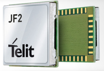
    Telit's Jupiter JF2 GPS module.
    Telit’s Jupiter JF2 GPS module.

    The TireVigil solution uses Telit’s Jupiter JF2 GPS module, a compact, low-power device that provides enhanced accuracy to help locate vehicles in the event of an emergency or at any time. TireVigil receives tire data from TMPS sensors, then communicates in real-time over the cellular network using the Telit HE910 cellular module. Part of the xE910 module family, the HE910 is pin-to-pin compatible with a suite of modules enabling TireStamp to customize its products to enable connectivity across cellular technologies and geographies.

    “Our customers are typically in the maintenance space,” said Scott Feagan, Chairman and CEO of TireStamp. “Reliability and support are extremely important to them – and to me. Pair that with family compatibility for fast time-to-market and global expansion, the opportunity to bundle connectivity with positioning, affordable pricing and on-time availability, and it’s easy to see why we chose to work with Telit.”

    “Between fleets and personal vehicles, more than a billion tires are sold around the world each year,” said Mike Ueland, president of Telit Americas. “Telit has a long history of supporting fleet telematics and automotive solutions and we’re pleased to enable the world’s leading tire pressure management system.”

  • ACR Electronics Launches New Locator for Aviation

    A new emergency locator transmitter for aviation has received Cospas-Sarsat and FAA approvals and is now available for sale. The ELT 1000 by ACR Electronics, Inc., is designed with multiple installation configurations to reduce overall installation cost, the company said.

    The electronics maximize frequency stability and power while incorporating a new, built-in GPS navigational interface, the company said. Including GPS data in the emergency transmission allows search-and-rescue personnel to know the location within 100 meters in less than a minute. Designed to accommodate multiple installation configurations, the new ELT 1000 is a quick retrofit for obsolete 121.5 MHz ELTs.

    “We are very excited to announce this new ELT to the general aviation market. This is the first new ELT from the Artex family in many years and the first we have designed and certified at ACR. We feel we are bringing an ELT that offers excellent value, along with the highest quality workmanship available to the market,” said Gerald Angeli, president and general manager.

    Built under the exacting standards of AS9100C quality certification, the ELT 1000 exceeds all government and regulatory standards including the latest FAA guidelines with its new robust stainless steel mounting strap.

    ELT 1000 features and specifications:

    • Quick and easy retrofit for general aviation aircraft
    • Single antenna output for emergency transmission on both 406 MHz (Cospas-Sarsat) and 121.5 MHz frequencies (local Search & Rescue)
    • Enhanced positional accuracy with a built-in GPS interface that does not require aircraft power
    • Encoded digital message broadcasts aircraft identification/registration and owner/emergency contact details
    • New stainless steel mounting strap for increased stability that complies with the most current FAA guidelines
    • Simple self-testing from the cockpit. When combined with 406Test.com, the self-test will provide SMS/e-mail confirmation within seconds that the ELT signal reached the satellites successfully
    • New hermetically sealed G-Switch for increased reliability.
  • Azuga Takes on Distracted Driving for Fleet Managers


    To recognize National Safety Month and to highlight the growing dangers of distracted and reckless driving, Azuga has published a Fleet Stats infographic showing the dangers of auto accidents its fleet tracking programs are designed to prevent.

    Of the 41,000 Americans killed each year in traffic accidents, nearly 5,000 die as a result of crashes involving large fleet trucks. An additional 13,000 die as a result of a speeding-related accidents. Azuga offers two programs for fleet managers: SpeedSafe and DriveSafe.

    The programs combine GPS, a driver behavior and rewards system, vehicle health reports, and plug-and-play installation to combat reckless and distracted driving. DriveSafe prevents talking and texting when the vehicle is in motion. The distracted driving technology locks down a driver’s screen and only allows phone numbers that the employer’s policy allows. Policies can be applied at the individual driver level to allow certain calls and texts (for instance, allow incoming calls from home, the office, and school.)

    With SpeedSafe, a fleet manager controls speeding on residential streets, in school zones, and in adverse weather conditions. Going beyond simple control, a fleet manager also gets reporting and analytical tools to help quickly identify problem areas and track and train drivers over time.

    National Safety Month is sponsored by the National Safety Council. According to distraction.gov, using a mobile device while driving causes an estimated 28 percent of traffic accidents. Further, the National Safety Council estimates $40 billion cost to United States citizens each year.

    Azuga says its customers have been able to decrease the number of speeding events by 40 percent and decrease overall liability, which translates into an average 15 percent savings on insurance premiums.

  • New GEO Business Show Deemed a Success

    Success of the inaugural GEO Business show, held in London May 28-29, means the new gathering will take place again.

    The show saw more than 1,600 attendees from 39 countries. It combined a bustling central trade exhibition — featuring 118 exhibitors showcasing the latest geospatial technology and services — with a conference program of cutting-edge keynotes and presentations plus 96 commercial workshops.

    GEO Business is organized in collaboration with the UK’s key geospatial and survey organizations — the Survey Association (TSA), the Royal Institution of Chartered Surveyors (RICS), the Chartered Institution of Civil Engineering Surveyors (ICES) and the Association for Geographic Information (AGI).

    “The show’s unifying vision was to promote closer collaboration across the geospatial community and to provide a platform that effectively showcases both the professionalism of this industry and the role that it will play in the future economic growth of our country,” the organizer said in a statement. “To cite the words of one exhibitor, Derry Long, business development manager at MBS Survey Software, the new show marked ‘the dawn of a new era for the geospatial community’.”

    “From the moment the doors opened, there was a real buzz on the show floor and it was evident that we had gained the support from the community in the launch of this show,” said Versha Carter, group exhibition director of GEO Business. “It was fantastic to see the entire geospatial industry united together doing business. There was a genuine sense of the industry coming together to connect and share their experiences and methods, to see how they could learn from each other and improve the way they work. We now have a really solid foundation from which to grow and develop the show, and are already looking forward to GEO Business 2015.”

  • Trimble CenterPoint RTX Correction Service Available for Heavy Construction

    Trimble’s CenterPoint RTX correction service is now available for heavy civil construction applications. Available worldwide as a subscription service, CenterPoint RTX offers construction companies a flexible and easy-to-deploy option for conducting pre-bid reconnaissance and initial site measurements without using a traditional base station, the company said.

    “Offering CenterPoint RTX for heavy construction applications further extends the Trimble Connected Site strategy to simplify site operations. CenterPoint RTX will make it easier to collect high-quality data in the early phases of site establishment, improving material estimates and job bids,” said Roz Buick, vice president and general manager of Trimble’s Heavy Civil Construction Division. “With more accurate material estimates and bids, contractors can incur fewer change orders and avoid unnecessary costs and delays.”

    Based on Trimble RTX technology, CenterPoint RTX is a satellite-delivered positioning source that streams GNSS corrections to rover systems with the Trimble SPS985 GNSS Smart Antenna, SPS985L GNSS Smart Antenna, or SPS855 GNSS Modular Receiver. There is no need to have an additional data plan or additional hardware.

    The CenterPoint RTX service is a correction source for construction sites in the pre-bid and site planning phases. Construction surveyors and estimating teams can use CenterPoint RTX to perform topographic surveys, estimate quantities, and conduct site planning quickly and easily, before a base station is needed on site for machine control and other high-accuracy applications.

    “Trimble strives to provide advanced GNSS correction services that fit our customer’s specific needs and applications,” said Patricia Boothe, general manager of Trimble’s Positioning Services Division. “For the heavy civil construction industry, this means a job crew can arrive on a new construction site and begin conducting site measurements and collecting data right away. CenterPoint RTX also makes it easier to work on multiple construction sites with the same rover system. There is no need to pair the rover with an existing base station at each individual site.”

    Trimble CenterPoint RTX is a subscription service available through Trimble Positioning Services in North America, South America, most of Europe, Russia and the Commonwealth of Independent States (CIS), Africa, Asia, and Australasia.

  • Trimble Adds Automated Mapping and Plotting to Office Suite for GIS Professionals

    Trimble has introduced a new version of its office software suite used by surveyors and geospatial professionals for processing and analyzing geospatial data. Trimble Business Center Version 3.21 introduces new coordinate reference systems and a specialized Advanced Drafting module, which enables faster project turnaround and better decision making.

    The optional Advanced Drafting module adds highly customizable templates and simplified selection tools, which are designed to reduce the time required to generate high-quality deliverables, such as geospatial maps and corridor cross-sections. Now, professionals working on road, pipeline, and railway projects can achieve efficiency gains through the software’s new automated cross-section plotting functionality.

    Also included in the new module is the ability to create 3D PDFs so that team members and clients can collaborate from any computer or mobile device using Adobe Reader software.

    “Trimble Business Center is the enterprise solution for surveyors and geospatial professionals to produce high-quality deliverables,” said Alain Samaha, business area director of GIS and Software for Trimble’s Geospatial Division. “These new capabilities demonstrate the continued evolution of our software portfolio to provide customers with an end-to-end solution to fulfill their client’s high-end requirements in the most efficient way.”

    Trimble Business Center Software version 3.21 and the Advanced Drafting module are now available through Trimble’s Geospatial Distribution Channel.

  • Trimble Adds Automated Mapping and Plotting to Office Suite for Surveyors

    Trimble has introduced a new version of its office software suite used by surveyors and geospatial professionals for processing and analyzing geospatial data. Trimble Business Center Version 3.21 introduces new coordinate reference systems and a specialized Advanced Drafting module, which enables faster project turnaround and better decision making.

    The optional Advanced Drafting module adds highly customizable templates and simplified selection tools, which are designed to reduce the time required to generate high-quality deliverables, such as geospatial maps and corridor cross-sections. Now, professionals working on road, pipeline, and railway projects can achieve efficiency gains through the software’s new automated cross-section plotting functionality.

    Also included in the new module is the ability to create 3D PDFs so that team members and clients can collaborate from any computer or mobile device using Adobe Reader software.

    “Trimble Business Center is the enterprise solution for surveyors and geospatial professionals to produce high-quality deliverables,” said Alain Samaha, business area director of GIS and Software for Trimble’s Geospatial Division. “These new capabilities demonstrate the continued evolution of our software portfolio to provide customers with an end-to-end solution to fulfill their client’s high-end requirements in the most efficient way.”

    Trimble Business Center Software version 3.21 and the Advanced Drafting module are now available through Trimble’s Geospatial Distribution Channel.

  • Google Maps Adds Terrain View

    Google Maps now has Terrain View, which enables users to see terrain maps for an area.

    Terrain view shows the 3D elevation of natural geographic features, such as mountains and canyons. Topographic contour lines are overlaid on the map to show elevation levels with altitude information displayed in gray numbers.

    Google Maps also offers traffic, transit, and biking views.

    Google Maps tweeted about the new terrain feature, showing an example:

    GoogleMaps-Terrain

    Photo: Google


  • Lockheed Misses GPS III Deadline After Production Delays

    The U.S. Air Force is shopping for alternative companies to head  the GPS III program after its current contractor, Lockheed Martin Space Systems, hit production delays, according to the Denver Post.

    There have been technical problems with the first GPS III satellite navigation system, which is supplied by Lockheed Martin subcontractor Exelis, the newspaper reports.

    After the current eight-satellite contract is fulfilled, contracts to build the 22 remaining spacecraft are up for bid, according to a notice posted by the Air Force on the Federal Business Opportunities website.

    Exelis’ navigation system was producing signal interference that prevented Lockheed from delivering by its target date earlier this year, which is now anticipated for delivery in 2015. The system is undergoing rigorous tests.


  • ION International Technical Meeting 2015 Now Accepting Abstracts

    Abstract submissions are now being accepted for The Institute of Navigation’s (ION) International Technical Meeting (ITM), set for January 26-28, 2015, at the Laguna Cliffs Marriott Hotel, Dana Point California. Abstracts are being accepted through October 3, 2014.

    This year’s plenary session will focus on “The Human Factor: Interpreting and Acting on Navigation Data,” and will explore how navigation data is viewed through the lens of human perception and how novel sensing technologies will impact the human experiences.

    This year for the first time, all technical papers for ITM 2015 will be peer reviewed. Manuscripts will be designated as a primary paper, or as an alternate paper, in the onsite program based on the session chairs’ peer review of the full manuscripts.

    ITM 2013 features more than 150 technical papers presented on a diverse array of topics including:

    • Advanced RAIM and Autonomous Integrity
    • Alternative Sensors and Emerging Navigation
    • Technologies
    • Augmentation Systems (SBAS and GBAS)
    • Aviation and Marine Applications
    • Collaborative Sensing and Multisensor Fusion
    • Emerging GNSS and Modernization
    • GNSS Processing and Integration
    • Human-Centered Navigation
    • Interference, Spectrum Management, and
    • Backups to GNSS
    • MEMS, Timing and Micro PNT
    • Quasi-Zenith Satellite System
    • Receivers and Antenna Technology
    • Robot and Autonomous Vehicle Navigation
    • Space and Atmospheric Weather
    • Urban, Indoor and Terrestrial Applications

    For more information about ION’s International Technical Meeting 2015, please visit .


  • U.S. Army, Lockheed Martin Complete Second Autonomous Convoy Demonstration


    The U.S. Army Tank Automotive Research, Development and Engineering Center (TARDEC) and Lockheed Martin successfully demonstrated additional capabilities of the Autonomous Mobility Appliqué System (AMAS) May 29 at the Department of Energy’s Savannah River Site in South Carolina.

    They conducted a driverless line-haul convoy with seven military trucks at speeds up to 40 mph.

    The AMAS CAD II demonstration built upon capabilities demonstrated at Fort Hood, Texas, in January, when three unmanned military trucks negotiated oncoming traffic, followed rules of the road, recognized pedestrians, and avoided various obstacles at speeds up to 25 mph in an urban environment.

    AMAS is a Joint Capability Technology Demonstrator, or JCTD. That means it’s a joint program between the U.S. Army and the U.S. Marine Corps. The AMAS common appliqué kit consists of the bi-wire active safety kit and the autonomy kit. It uses GPS, lidar systems, Automotive radar, and commercially available automotive sensors to make the system affordable. The AMAS JCTD goal is to standardize these kits across both the Army and Marine Corps and give the warfighter the ability to transform ordinary vehicles into optionally manned vehicles.

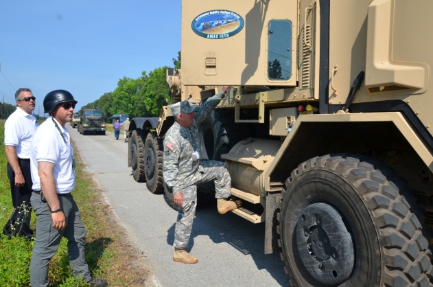
    Colonel Bruce B. McPeak, Director of Materiel Systems, Combined Arms Support Command, climbs into a Heavy Equipment Transporter (HET) for an autonomous ride-along.
    Colonel Bruce B. McPeak, Director of Materiel Systems, Combined Arms Support Command, climbs into a Heavy Equipment Transporter (HET) for an autonomous ride-along.

    TARDEC is working closely with the U.S. Army Training and Doctrine Command (TRADOC), military users, and the acquisition community to advance the development of autonomous appliqué systems for tactical vehicles and make these capabilities available by 2020.

    Autonomy-enabled vehicles will reduce accidents while augmenting the warfighter, and increase capabilities by creating greater stand-off distance from danger, which would make supply distribution safer and more efficient, and provide the flexibility to adapt to tomorrow’s ever-changing and evolving threats.

    “The driverless vehicle is coming in both commercial and military applications,” said Bernard Theisen, TARDEC’s AMAS Technical Manager. “The Army is at the forefront of this technology.”

    Military and industry VIPs drove alongside the convoy in a bus to watch the unmanned convoy demonstration.
    Military and industry VIPs drove alongside the convoy in a bus to watch the unmanned convoy demonstration.