GPS World Publisher Steve Copley is attending GEO Business 2014, where GPS World is a sponsor. The show is being held in London this week. He’s been tweeting from the show. Follow his tweets here, and GPS World’s Twitter account here.
GEO Business 2014 is a new geospatial event for everyone involved in the gathering storing, processing and delivering of geospatial information. It is organized in collaboration with The Chartered Institution of Civil Engineering Surveyors (ICES), The Association for Geographic Information (AGI), The Royal Institution of Chartered Surveyors (RICS) and The Survey Association (TSA).
McMurdo Group, an end-to-end search and rescue (SAR) and maritime domain awareness (MDA) company, has acquired Techno-Sciences, Inc. (TSi), a provider of SAR satellite ground stations, integrated emergency response center systems and coastal surveillance solutions. Terms of the acquisition were not disclosed. TSi’s Beltsville, Maryland, location becomes the U.S. headquarters for McMurdo Group, a division of Orolia, global specialist in critical GNSS solutions.
TSi has been instrumental in the development of the COSPAS-SARSAT international satellite-based SAR program, which has helped to save more than 35,000 lives worldwide since 1982. TSi is also actively involved in the next-generation COSPAS-SARSAT system, MEOSAR (Medium Earth Orbit Search and Rescue), which will greatly improve the existing SAR process with near-instantaneous detection, identification and location of emergency distress beacons.
MEOSAR, currently in its demonstration and evaluation phase, is expected to have initial operational capability in 2016 and full operational capability by 2018. MEOSAR will use SAR-enhanced Galileo (Europe), GPS (U.S.) and GLONASS (Russia) satellite constellations for greater global coverage and includes innovative end-user beacon functionality such as a return-link service on Galileo satellites to acknowledge distress signal receipt and provide ongoing rescue effort status.
“The acquisition of TSi firmly establishes McMurdo Group as the global leader in satellite-based search and rescue solutions. We are the only provider capable of supplying a single-vendor, end-to-end COSPAS-SARSAT emergency solution with a seamless ecosystem of products, technologies and processes that will streamline and expedite search and rescue efforts,” said Jean-Yves Courtois, CEO, McMurdo Group and its holding company Orolia Group. “TSi expands our global sales, support and customer footprint and adds to our already extensive expertise in SAR and MDA. We look forward to developing a U.S. SAR Center of Excellence to include manufacturing, distribution and support of McMurdo Group’s broad solution offering of distress beacons, AIS equipment, satellite communications units and emergency control centers equipped with search and rescue management software.”
TSi solutions are installed in more than 20 countries worldwide and include satellite ground stations or local user terminals (LUTs), rescue and mission control centers, and coastal surveillance/instruction detection systems. TSi installed the world’s first operationally ready six-channel MEOSAR LUT (MEOLUT) in 2011 for the U.S. National Oceanic and Atmospheric Administration (NOAA) and has recently completed a second NOAA installation (March 2014). With a team of 40 employees, TSi has a prominent list of government, military and commercial customers in Asia, Europe, Africa and the U.S. (including NOAA, NASA and the U.S. Navy).
Port Douglas, Queensland, Australia, is looking to reduce any potential deaths from falling coconuts, reports ABC News.
The Douglas shire council is mapping the GPS locations of its coconut trees, to reduce the danger. Mayor Julia Leu says more than 4,000 mature coconut palms have been identified in Port Douglas.
“All local governments that have coconut palms in their area do have a de-nutting program. However the de-nutting process is very costly,” Leu said. “What we want to do is look at this in a far more innovative way.”
On average, 150 people die annually around the world from falling coconuts.
The European GNSS Agency (GSA) and Rx Networks Inc., a mobile location technology and services company, announced the results of tests conducted by the company measuring the performance of Galileo when used in various combinations with GPS and GLONASS.
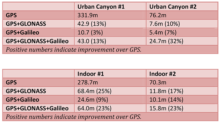
Tests were conducted in real-world environments, including urban canyons and indoors. These environments pose significant challenges to location accuracy due to multipath and obstructed views of satellites. Each test consisted of a three-hour data capture of GNSS signals, which was later replayed to produce hundreds of fixes using a multi-constellation GNSS receiver from STMicroelectronics.
The results showed that using Galileo with one or more other GNSS constellations provides significantly more accurate location fixes compared to GPS alone, when indoors or in urban canyons. As expected, the GPS+Galileo combination did not exceed the performance of GPS+GLONASS, due primarily to there only being four Galileo satellites available at the time of the testing. It is expected that, as more Galileo satellites are launched, the combination of Galileo with GPS will show further improvements in performance, GSA and RX Networks said.
According to Gian-Gherado Calini, head of Market Development at the GSA, “Dual-constellation GNSS designs are the standard for many smartphones and other devices. The combination of GPS and Galileo provides a robust solution and is expected to offer performance that will meet or exceed end-user expectations.”
“The results should be encouraging to any GNSS chipset manufacturer who is considering adding Galileo as a competitive differentiator,” said Adrian Stimpson, senior vice president of Sales and Marketing, Rx Networks.
Test Results
Recent test results confirm that Galileo significantly improves accuracy in challenging environments:
The tables above show the summary results for various scenarios and constellation combinations. The GPS row shows the absolute 2D errors in meters. All other rows show the improvement (+) or degradation (-) in meters and percentages relative to GPS-only fixes. All measurements are within the 95th percentile.
Globecomm, a global provider of communications solutions and services, has received a contract extension from NATO Communications and Information Agency (NCI Agency) valued at $9.6 million to extend communication services and onsite support for the company’s previously deployed GPS-Based Force Tracking System (FTS).
The FTS provides NATO with high levels of tracking data and messaging traffic. It enables NATO to identify where its personnel are located at all times, identify other multinational forces, and have the ability to do so in routine and operational situations. This is critical in assisting with the identification of friendly forces and helps prevent “blue-on-blue” incidents, the company said.
Globecomm previously announced approximately $74.7 million in contracts from NATO for this project to design and install a GPS FTS, bringing the combined contract value to approximately $84 million.
“Globecomm is pleased to receive this contract extension to continue to deliver this important service,” said Paul Knudsen, vice president of Globecomm’s Eastern Atlantic Team. “We completed an upgrade of this system last year under a separate contract that was previously announced. Globecomm has been providing this service since 2007.”
Geoforce, Inc., an international provider of asset management solutions for the oil and gas industry, has announced the widespread commercial availability of the GT0, a tiny industrial GPS asset-tracking device. The device is designed to track and remotely monitor assets too challenging for other GPS devices, the company said.
“Geoforce is constantly trying to gauge what our customers will need next,” said James MacLean III, Geoforce’s president and CEO. “What we’ve been hearing out there is this: smaller, easier and whenever possible — more affordable. We’ve purpose-built this device to try and meet those needs without dropping the quality-level our customers deserve.”
The GT0 has a powerful omni-directional antenna, allowing for placement in almost any orientation on an asset. The tracking device is engineered with RFID and GPS technology for location and identification, as well as QR coding for mobile scanning of product information. Its compact size allows the tag to fit on equipment where previous larger and bulkier asset-tracking devices could not be implemented. It is an IP67 device (weatherproof) and has an optional metal bezel for added protection. It has an expected five to seven year battery life, making it a simple-to-deploy “slap and track” device.
More than 300 companies currently use Geoforce’s solutions to manage 100,000 assets across six continents. The GT0 was previously offered in limited release to several service and rental companies beginning in January of this year.
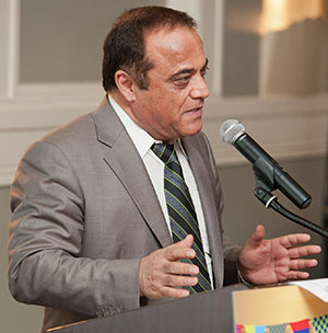
“Use any opportunity to create friendship and peace,” urged Javad Ashjaee, president and CEO of JAVAD GNSS, in a May 23 conversation with journalists. He decried the recent controversy about monitoring stations on both U.S. and Russian soil, saying it was based in misinformation and misinterpretations, inflated by a political crisis in a completely different area. “This [GNSS] is a good thing, that for 25 years kept us together. And if you see, there are lots of high-level meetings between U.S. and Russian officials, they are all very friendly meetings.”
A transcription of his remarks appears here, below the following main points and clarifications that he wished to make:
• Earlier this year, Russia sought GLONASS monitoring stations in the United States, not for uploading any data, but for monitoring GLONASS satellites to provide more accurate orbit and clock information, for the free and open benefit of all users.
• The Russian general who threatened to close down monitoring stations on Russian soil that contribute data to the International GNSS Service was immediately and roundly criticized by Russian scientists and surveyors. The general subsequently retracted his remarks.
• The 11-hour GLONASS outage on April 1 was not due to a wait for all satellites to pass over ground control stations on Russian soil to receive a fresh upload of data. GLONASS has the capability (as does GPS) to make such updates via inter-satellite communication. The delay was caused by the time it took to find the bug in the erroneous software that had been uploaded, and to correct it.
• Ashjaee also noted that “No military activity requires millimeter accuracy. It is only scientific applications for humanitarian tasks that require millimeter accuracy. Needing more monitoring stations, such as the IGS stations, is only for that purpose.”
The Background
Javad Ashjaee, founder and CEO of JAVAD GNSS, contacted GPS World on May 20 with a message: “I had a discussion today with the head of the GLONASS program in RosKosmos regarding the tracking sites that they wanted to establish in the United States, and the subsequent events. What has been published in most U.S. media is far from the truth. It is time that we contribute to defusing problems rather than putting more fuel on the fire. The world has enough problems already.”
The Full Statement
This is the story of GPS/GLONASS. It also gives some insight as to how things get out of control, and much, much bigger issues like war and things like Ukraine get created. It is just a tiny, simple example.
When I first heard the issue of GLONASS about 25 years ago and was invited by RosKosmos to Moscow, I didn’t think of Communism or anything political, I thought “30 satellites free, that they’re willing to give to the world, free of charge.” That’s how I got excited. Recently, GPS World published a wonderful history of the growing development of GLONASS and GPS.
What bothers me now is some negative reactions that I see towards GLONASS. It seems that when they see something negative about GLONASS, they enjoy it. In the reports, read between the lines. When there is a problem with GLONASS, you sense some sort of happiness. There is something of “them versus us.”
There was the question, “Why do they need things in our country? Don’t they have them in their country?”
When people don’t know each other, they fear and they create fear.
One thing we should look at: GLONASS is good for all of us. As President Reagan offered GPS free of charge to the world, and everybody applauded him — the Russians have done the same thing. In Oklahoma, California, everywhere, farmers and surveyors are using GLONASS free of charge, the same as GPS. And GLONASS has been better, and I emphasize, it has been better because they didn’t encrypt their code so that we had to go behind and decipher and decrypt and all the trouble that we went to during the past 20 years, because GPS didn’t think that we need carrier phase.
GLONASS is good for America, for the world, as is GPS. If there is a problem with GLONASS, we must be unhappy, as we are unhappy when there is a problem with GPS. And if we can help GLONASS, we must help GLONASS. There is nothing to fear about war, nobody needs [millimeter-level] accuracy of GPS or GLONASS if there is a war between super-powers.
We should all want GLONASS to give precise information. We care about centimeter-level accuracy, the military doesn’t. Five-meter accuracy is good enough for them. To improve the precise-orbit information of GLONASS is the concern of surveyors and those that need precision GPS.
Now, what’s the issue? GLONASS needs 50 reference stations all around the world to monitor the orbits of its satellites, to make the precise-orbit information [furnished to users] better. Not to upload information to the satellites. For this, one station is enough, for both GPS and GLONASS, because both have inter-satellite connections that can do this.
There was speculation in early April that it took GLONASS 11 hours to correct a software bug because it took that long for all the satellites to pass over a control station on Russian soil. This was not the case, I have learned from conversations with their engineers and with the head person responsible for all of this. One engineer made a mistake and uploaded the wrong software. Until they could find it and debug it — and it took them 11 hours to do so — they could not upload correct software to the satellites.
What they are asking for from the United States is not an upload station. They need as many [globally-distributed] monitoring stations as possible; 50 is good.
The International GNSS Service (IGS) has 300. To have a good orbit determination for scientific work, to get to the depth of centimeter- or millimeter-level accuracy, the objectives of IGS reports is to have 200 or 300 monitoring stations. For military work, three or four is enough.
Russia already has more than 50 monitoring stations. They use IGS stations. They didn’t need to ask for anything. Even [data from] the units we have in our San Jose office is available to everybody.
So I asked the GLONASS people, “Why did you ask? You have [access to more than] 200 monitoring stations!”
This was the issue: it was only political. When RosKosmos made internal presentations in Russia to their [government and military] decision-makers, they were asked, “OK, these stations are controlled by who?” By the IGS, they answered. They were told “You must have stations under Russian control.”
I explained to them that IGS stations, for them, are more convenient and more secure. If President Obama told the IGS, told Stanford University and 200 other universities, to turn off their IGS stations, there would be a lot of disagreement! President Obama could turn off Russian stations on U.S. soil. I told them, IGS stations are more convenient and more secure for you than your own stations, and they understood. They are not pushing for it, they said those officials on the top, they know nothing. They were asking that we must have five stations under our control.
If you understand this: that the issue was [Russian internal] political, that they don’t need anything. They already get the precise orbit data from IGS stations.
Now, the second part or episode of this problem: when a Russian general heard that the United States said “No” to the request for Russian-controlled monitoring stations on U.S. soil, he said “Oh, now they don’t let us do this? We will turn off their stations in Russia.” All surveyors and all scientists in Russia jumped at that general, and he retracted what he had said.
But people who didn’t understand this [that IGS-participating stations in Russia have nothing to do with controlling GPS satellites or supplying GPS data to users], they put their own statements in the press, they added fuel to the fire.
The Q&A
When asked how surveyors in Oklahoma could help GLONASS, as he had urged, Ashjaee replied “They can write to their senators and ask, why didn’t you let monitoring stations be in the heart of Oklahoma too?”
Afterthought
Once the first version of this online story was posted, Javad Ashjaee sent in this further comment:
“Part of my admiration for the GLONASS team is that they managed to pull this project off amidst their worst economical, social, and political times. Compare their situation with GPS that had a huge budget (and still ran way over budget) and with Galileo that took several rich countries to put the budgets and technology together. GLONASS also offered this free and unrestricted service to the world without making any political gestures. No encryption of codes and no selective availability either.
“There is an abundance of opportunities to create hostility, and there are enough people to promote it. Situations like this are rare that we can grasp the opportunity to promote friendship.”
The Trimble BD930-UHF high-performance integrated UHF receiver.
Trimble has introduced the Trimble BD930-UHF receiver and communication module. As part of Trimble’s GNSS OEM portfolio, the new compact module features centimeter-level, Real-Time Kinematic (RTK) positioning capabilities coupled with an integrated UHF receiver for precise mobile positioning. The BD930-UHF module’s connectivity and configuration capabilities allow system integrators and OEMs to easily add GNSS, centimeter-level positioning to specialized or custom hardware solutions.
“The OEM and system integrator communities demand high performance, reliability and support for their positioning solutions,” said Dale Hermann, general manager of the Integrated Technologies division at Trimble. “The Trimble BD930-UHF delivers the latest GNSS and communication technology in an easy-to-integrate form factor for demanding conditions and applications such as field computing, port automation and lightweight robotic or unmanned vehicles. With the BD930-UHF module, customers are purchasing a solution not just a GNSS receiver.”
Taking advantage of Trimble’s expertise in both GNSS and UHF communications, the Trimble BD930-UHF module has been designed for applications requiring centimeter accuracy in a compact package. By integrating wireless communications on the same module, the task of receiving RTK corrections is significantly simplified.
The triple-frequency GPS/GLONASS/BeiDou/Galileo BD930-UHF provides customers with a multi-constellation solution that can reduce their integration effort and time to market. Ethernet connectivity and onboard web server allows high-speed data transfer and configuration via standard browsers. USB and RS232 ports are also supported. By tightly integrating communications with the GNSS receiver, integrators can reduce costs, power, weight and size.
The Trimble BD930-UHF is expected to be available in July 2014 through Trimble’s Precision GNSS + Inertial sales channel worldwide.
There has been a lot of GNSS-related news in the past month, so I thought I’d do a quick review of the importance (and possibly unimportance), of news you may have heard about.
Just because some GPS satellites weren’t broadcasting CNAV on L2C and L5 doesn’t mean your receiver isn’t using L2C or L5. On the contrary, if your receiver was designed to handle L2C and L5, it’s likely already been using them. The CNAV is just the message being transmitted on the L2C and L5 carrier along with the code. If your receiver tracks L2C and L5, it’s likely already using the carrier (phase) observations. However, even then there are only a limited number of satellites broadcasting L2C and L5 carriers. Specifically, there are 11 satellites broadcasting L2C and four broadcasting L5, meaning that your receiver is roughly tracking one L5 satellite at any one time during the day and several satellites broadcasting L2C.
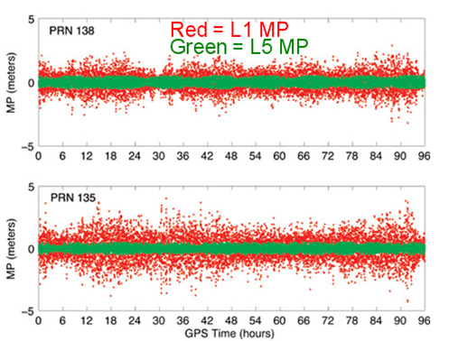
The C/A code (NAV) message on L1 that your receiver already uses today is good enough. Your receiver doesn’t need the CNAV message on L2C or L5 to utilize the L2C or L5 carrier observations. That’s not to say there’s no benefit to CNAV on L2C and L5, but for RTK or post-processing, the value is largely in the carrier observations. In the future, when L2C and L5 are fully deployed (or near fully deployed), the L5 CNAV does have some distinct advantages, but that’s a few years down the road. To give you an idea of the benefit of L5 when there are enough GPS satellites broadcasting L5 , take a look at the following illustration published by Dr. Richard Langley from the University of New Brunswick comparing the reduction of code multipath on L1 and L5 of two WAAS GEO satellites.
Reduction of code multipath using L1 and L5 on WAAS GEO Richard B. Langley, Hyunho Rho
For the full text of the Langley/Rho article on L5 and WAAS that appeared in the May 2009 issue of GPS World magazine, click here.
Second GPS IIF Satellite of 2014 Launched May 16
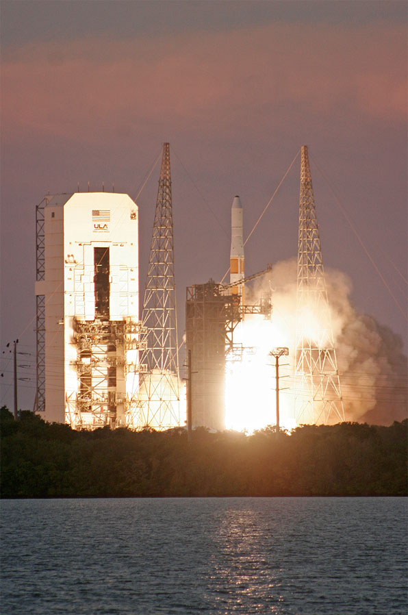
On May 16, the second GPS satellite of 2014 was launched successfully from Cape Canaveral in Florida. It was the sixth model IIF GPS satellite, of which 12 are being built, before transitioning to the next-generation model GPS satellite named GPS III. It began transmitting on May 21, 2014, but is not yet set healthy.
Photo credit: Spaceflight Now.
The GPS model IIF satellite broadcasts the legacy GPS signals as well as the new civilian L2C and L5 signals.
Normally, a launched GPS satellite is set healthy (and automatically begin being used by your GPS receiver) within 30 days of launch, sometimes much sooner. However, the IIF GPS satellite launched in February of this year still hasn’t been set healthy, the reason reportedly being an extended navigation test reported here.
A third GPS IIF satellite is scheduled for launch this year on July 31.
During the post-launch interview last Friday, the Air Force stated that the remaining GPS IIF satellites (six) will be launched by the end of 2016. From previous conversations I’ve had with Air Force officials, they’ve stated that there could be an overlap between IIF and III satellite launches. In other words, the first GPS III satellite could be launched before all IIFs have been launched.
“Since March 15, 2014, the Air Force has been conducting functional checkout on a GPS satellite, designated Space Vehicle Number (SVN) 64. SVN-64 broadcasts a data message that clearly indicates SVN-64 is unusable for navigation. Nevertheless, the U.S. government has confirmed that certain GPS receivers are using data from SVN-64, in violation of GPS interface specifications, resulting in outages or corrupted, inaccurate position calculations.”
CGSIC reports that the GPS continues to operate and is fully functional.
In Australia, faulty GPS receivers on roughly 1,000 fleet vehicles caused an apparent GPS “outage” about a month ago.
The U.S. Air Force GPS Operations Center reported that in mid-May tests, “PRN 30 [was] broadcasting almanac datasets that do not reflect constellation changes that occurred since it was last uploaded with navigation message data. [. . . ] The utilization of these almanacs in a manner that regards the time of week, but neglects or mishandles the week number (effectively executing as if the current week number is the week number associated with these almanac parameters), will result in an increasing error in visibility determination and other almanac based estimations (elevation/azimuth, Doppler shift, SV clock offset from GPS time, etc) as the dataset’s actual week offset from the current week increases.”
First Two FOC Galileo Satellites Arrive in French Guiana for Launch Preparation
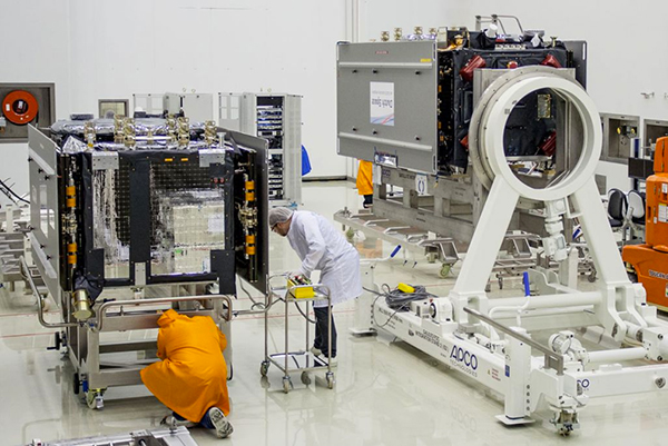
The first two Fully Operational Capability (FOC) Galileo satellites arrived in the French Guiana in preparation for launch this summer. When launched into orbit, they will join four IOV (In-Orbit Validation) Galileo satellites launched in 2011 and 2012.
The first FOC satellite launch may signal the beginning of Galileo “production” launches of one pair per quarter. Giuliano Gatti, Head of ESA’s Galileo Space Segment Procurement Office, stated that “A steady stream of satellites is foreseen, coming from OHB to ESTEC for acceptance testing and then on to French Guiana. Thanks to the preparatory work done with these pioneer satellites, future Galileos will be processed more rapidly.”
OHB is the prime contractor for a total of 22 FOC Galileo satellites. Those are in addition to the four IOV Galileo satellites.
The two Galileo satellites in the clean room.
Massive GLONASS System Failure
On April 1, the entire GLONASS system was inoperable for about 11 hours. A second, partial failure involving eight GLONASS satellites occurred on April 14 and lasted for about 30 minutes. There were many reports of RTK receivers not operating properly, and some manufacturers instructed their users to “turn off” GLONASS tracking capability on their receivers.
Subsequently, mathematical mistakes were blamed for the failures. The head of the Russian Space Agency, Oleg Ostapenko, stated that the problem would be fully resolved by mid-May and that there is almost no chance of a similar failure happening again.
Some news media are reporting that such an action by Russia would have an effect on GPS.
It would not.
What they’re talking about is discontinuing operations of some or all IGS (International GNSS Service) GPS stations in Russia. Those stations have nothing to do with the operation of GPS. They are simply CORS (Continually Operating Reference Stations). If anything, it will hurt Russian scientists (and scientists from other countries) more than anyone else.
Russian Rocket Launch Failure
Last week, Russia suffered its fifth rocket launch crash in the past four years. Fortunately for the GNSS user community, the rocket was not carrying any GLONASS satellites.
However, it raises serious concerns about the reliability of Russian rockets and launch procedures. Europe’s Galileo satellites are launched using Russian Soyuz rockets at Europe’s space port in French Guiana.
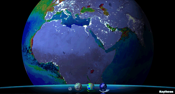
Available for iPhone, iPad and Android, VIIRS View provides mobile device users a look into the type of data meteorologists and climatologists use every day to track the weather and monitor Earth’s environment.
Based on data generated by the Visible Infrared Imaging Radiometer Suite aboard Suomi NPP, VIIRS View combines visible light imagery, low-light nighttime imagery and ocean chlorophyll concentration onto a full Earth globe, rotatable and zoomable on any location on the planet.
A desktop version of the VIIRS View app, launched in February, has been downloaded more than 90,000 times.
An original large format VIIRS View interactive tabletop display is being shown at Raytheon Booth #203 at the the 30th Space Symposium, being held this week in Colorado Springs, Colorado. GPS World Defense Editor Don Jewell is providing coverage from the symposium.
The app can be downloaded by searching VIIRS View at the Google Play and Android stores, or by clicking here:
The global space economy grew to $314.17 billion in commercial revenue and government budgets in 2013, reflecting growth of 4 percent from the 2012 total of $302.22 billion, according to The Space Report 2014. The report was issued this week by the Space Foundation during the 30th Space Symposium being held this week in Colorado Springs, Colorado. GPS World Defense Editor Don Jewell is providing coverage from the symposium.
Commercial activity — space products and services and commercial infrastructure — drove much of the increase. From 2008 through 2013, the total has grown by 27 percent. Commercial space products and services revenue increased 7 percent since 2012, and commercial infrastructure and support industries increased by 4.6 percent.
Government spending decreased by 1.7 percent in 2013, although changes varied significantly from country to country. Substantial space budget cuts in the United States outweighed gains in Canada, India, Russia, South Korea, and the United Kingdom, all of which increased budgets by 25 percent or more.
These new global space economic numbers come from the Space Foundation’s publication, The Space Report 2014:The Authoritative Guide to Global Space Activity, which was released today. Data was compiled from original research and a wide variety of public and private sources, and analyzed by Space Foundation researchers.
Key Findings
The 160-page book contains worldwide space facts and figures and is illustrated with photographs, charts and graphs. Within are myriad examples of the benefits of space exploration and utilization, the challenges facing the space sector, the opportunities for future growth and the major factors that shape the industry. In addition, The Space Report includes an overview of each sector, definitions, and up-to-date information on space infrastructure, facilities, launches and programs.
Following are just some of the many interesting facts and analyses found in The Space Report 2014: The Authoritative Guide to Global Space Activity:
Launches and Satellites
81 launch attempts took place in 2013, an increase of 4 percent from the 78 launches in 2012 (and above the five-year average of 79 launches per year).
The majority of these launches were conducted by Russia (32 launches), the United States (19), China (15), and Europe (7).
After two years of conducting fewer launches than China, the United States rose again to second place, partly due to an increased operational tempo as U.S. commercial providers launched cargo resupply missions to the International Space Station.
New launch vehicles made their first flights (or first successful flights) in five countries–the Antares and Minotaur V in the United States, Soyuz 2.1v in Russia, Kuaizhou in China, Epsilon in Japan, and KSLV-1 (also called Naro-1) in Korea.
The number of satellites launched during 2013 increased by nearly two-thirds compared to 2012. This was largely due to a significant uptick in the number of satellites with masses below 91 kilograms (200 pounds). These microsatellites constituted more than half of the 197 satellites launched in 2013.
Many of the microsatellites were short-lived technology demonstrations, but there is a considerable degree of interest in future possibilities for constellations of small satellites that provide valuable services on an ongoing basis.
Workforce
According to U.S. Bureau of Labor Statistics (BLS) data, the size of the U.S. space workforce declined for the sixth year in a row, dropping 3.5 percent, from 242,724 in 2011 to 234,173 in 2012 (the most recent full year for which data is available) – a decrease of about 8,500 workers. However, the changes varied by sector, with some portions of the space industry growing while others contracted.
The United States’ National Aeronautics and Space Administration (NASA)’s civil servant workforce remained essentially flat, declining by less than 1 percent to reach 18,068 in FY 2014. Although the workforce continues to become more concentrated at higher ages, NASA has experienced moderate success in recruiting and retaining young workers below the age of 35 during the past five years.
Both Europe and Japan saw increases in space workforces; the European industry workforce grew by 1.5 percent in 2012, adding approximately 500 employees; in Japan, the overall workforce grew by 11 percent, while employment at the Japan Aerospace Exploration Agency (JAXA), Japan’s government space agency, dropped.
The Space Foundation Index
As of December 2013, the Space Foundation Index was 94.22 percent above its value at inception in June 2005. The Space Foundation Infrastructure Index outperformed the S&P 500 and the NASDAQ during 2013, while the main Space Foundation Index and Space Foundation Services Index did not perform as well as the NASDAQ, but substantially better than the S&P 500. These indexes, which are updated daily on the Space Foundation website, are easy-to-understand mechanisms for gauging the financial performance of space industry companies listed on U.S. stock exchanges.
The Space Report is published annually by the Space Foundation, which works with a leading aerospace consulting firm, Futron Corporation, to research and analyze government and industry trends in space activity. The stock market analysis is provided by ISDR Consulting, LLC, a management consulting firm specializing in the space, satellite and technology sectors.
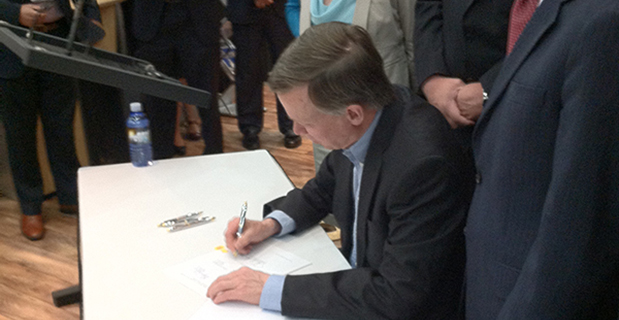
Colorado Governor John Hickenlooper signs a space-friendly bill at the 30th Space Symposium in Colorado Springs.
Colorado Ranks Third in Space-Friendly States
Governor John Hickenlooper (D) of Colorado made the trek from the statehouse in Denver yesterday to sign key space-friendly Colorado legislation at the 30th Space Symposium in Colorado Springs. The world’s largest annual space symposium takes place at the famed Broadmoor Resort in Colorado Springs and nominally draws a crowd of space aficionados and professionals, government and civilian alike, approximately 9,000 strong. Colorado House Bill #1178 is titled the “Sales And Use Tax Exemption for Qualified Property Used in Space Flight,” and it is hoped this legislation will help expand aerospace industry growth in Colorado. Spokesmen from the governor’s office and Tom Clark from the Colorado Space Coalition stressed that Colorado currently has the nation’s third-largest aerospace economy, and the new tax-exemption bill is part of Colorado’s strategic initiatives to support and grow one of its strongest industries. Indeed, Colorado Springs is known in government circles as the Home of Military Space. Several key space industry experts (both government and civil) present at the bill signing stated that the new tax exemption will add an important boost to keep Colorado ahead of the competition and further stimulate the state’s massive aerospace economy. Colorado is known as a national hub for geospatial technologies, remote sensing and satellite-based services. The space services and technology providers comprise the largest category of the state’s space economic activity, bringing in $6.3 billion in annual revenue. Currently, the Colorado space-based revenue is growing at a steady 8 percent annual rate. In conversation with Tom Clark, he admitted that in years past, Colorado has actually occupied the number-two raking for a state’s space-based economy, but was recently surpassed by Florida, which has similar tax-friendly legislation on the books. Clark was confident that with the new legislation Colorado would, like Avis, soon be number two again.
Colorado Gov. John Hickenlooper discusses space matters at the 30th Annual Space Symposium with Braxton Chairman of the Board Kevin O’Neil and Braxton CEO Frank Backes.