Report from the 30th Annual Space Symposium, May 19-22, Broadmoor Resort, Colorado Springs, Colorado
For the past five years, the first day of the National Space Symposium — now known simply as the Space Symposium, the largest symposium of its kind in the world — has started with an entire day dedicated to discussions of the cyber domain as it pertains to the DoD and civilian industry. The annual event highlights presentations from the major civilian cyber players and the senior cyber commander for the DoD, military services and government agencies. Several of the now-senior military officers worked for or with me as junior officers at some point in the past, and while that is an age-related humbling experience, it also makes me proud of them at the same time.
One major talking point, among many, is crystal clear: the U.S. government and civilian enterprises alike understand that cyber security is a critical mission and that cyber warfare, especially from a nation-state point of view, is a credible and viable threat to every government and civilian program and and to everyone today.
Major General Kevin McLaughlin, currently the commander of 24th Air Force and AFCYBER, the major command that takes cyber warfare to heart as a major mission, is one of those young officers in my past that make me proud today. Kevin was the luncheon speaker, and he put the Air Force role for cyber warfare in perspective as well as explaining how the Air Force role is integral to the overall Defense Cyber Enterprise. This integration role may seem like a small matter, but General McLaughlin’s explanation of Air Force and DoD cyber and IA (Information Assurance) synergy is critical to the success of his organization and mission.
This is critical because throughout my Air Force career and even today I constantly encounter commanders that are quick — too quick in my book — to explain, usually with great passion, why their particular mission(s) are critically important and “unique” to the Air Force writ large enterprise. Unfortunately, history shows us that “unique” organizations within services do not always fare well in budget scenarios, especially seques-castration budgets.
In my humble but experienced opinion, the senior officers commanding these “unique” organizations, be they cyber or otherwise, would fare far better if they conformed to Air Force budget requirements and still conducted their day-to-day unique missions just like a fighter pilot and fighter sortie. By that I mean you never know what you will encounter on a fighter sortie. You never know what the enemy will throw at you but you can rest assured that any plan, no matter how well conceived, will not survive initial contact with the enemy. The plan always changes and will hopefully be successful, but only because of flexibility, which has been described as the key to air power, and certainly not because of the “plan.”
So, I was assured when Gen. McLaughlin described “A Day in the Life of a Cyber Warrior” just as I would a fighter sortie. Prepare for the known threat and expect the unexpected. Be innovative and flexible, and you may win the battle and live to fight another day, because make no mistake about it, cyber warfare is a life-and-death struggle.
Fortunately, there do seem to be solutions that work, and a key point that was made numerous times by various speakers is that the small, small, usually local cyber warrior company is often times much more successful than the security behemoths that tend to get bogged down in their own administrative minutia. One of the companies mentioned was NDP, a small cyber and IA company in Boulder, Colorado, known for its work slaying the cyber dragons attacking the well-known SBIRS (Space Based Infrared System) program. The story goes that NDP, with only 50 employees, took on major global SBIRS cyber and IA issues and made it look simple. It is always the real experts that make it look simple. The chairman of one of panels really put it in perspective when he opined, “Would you really want Raytheon or Boeing providing anti-virus software for your home computer? Probably not! No slight to the mega companies intended, but I would go with the local, flexible and responsive small company, like NDP, every time.”
Thankfully, a lot of what I heard this year, as opposed to years past, conforms to the scenario I just described. Bad cyber actors (villains), local or nation state, are anticipated, and while the white-hat cyber warriors win more times than they lose, it is clear there is currently no panacea for cyber and IA threats — just hard work, diligence and flexibility to hopefully win the conflict.
AUVSI Unmanned System 2014 provided a showcase for new UAV/UAS products, and a dialogue on the rapidly growing industry.
Report from the Association of Unmanned Vehicle Systems International (AUVSI) Orlando, Florida, May 12-15, 2014
Just before the start of the huge AUVSI show, the FAA once again cautioned Unmanned Aerial Systems proponents that still more care is needed with UAS airspace access. The majority of UAS operators and manufacturers are making efforts to become compliant with reasonable FAA rules. Also, AUVSI had some good information on the economic benefits of UAS commercial applications to the U.S.
The annual AUVSI conference came down to the Sunshine State this year, and the sun did shine, with temperatures in the high 80s most days. The Orlando Convention Center is a huge place and AUVSI took up the majority of the South Exhibit hall along with a bunch of rooms where most of the technical presentations were run. With close to 600 exhibitors and more than 6500 attendees, this is still one of the bigger trade shows.
FAA Rules
However, just before the start of this huge show, the Federal Aviation Administration (FAA) once again cautioned Unmanned Aerial Systems (UAS) proponents that still more care is needed with UAS airspace access. It’s probably more than a coincidence that FAA released news of a March 22 close call at 2,300 feet between a US Airways airliner on approach to Tallahassee, Florida, and a model F4 Phantom Jet — UAS owner and operator unknown. And CNN also picked it up and animated it pretty quickly. As the industry as a whole strains to seek more airspace access, it’s difficult to understand how incidents like this happen. And, in the process, they push back all the good efforts that are being made by the large majority of UAS operators and manufacturers to demonstrate their ability and desire to become compliant with reasonable FAA rules.
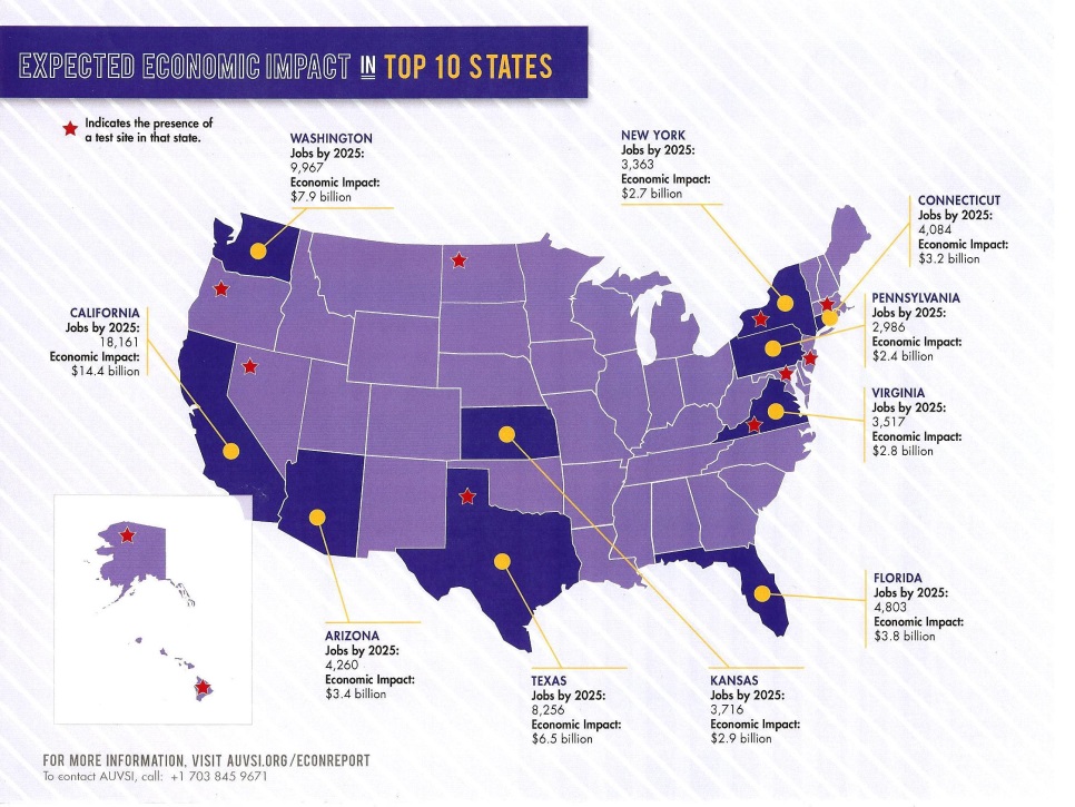
Nevertheless, AUVSI had some good promotional material available at the conference showing the economic benefit to the U.S. for UAS commercial applications — a $82 billion market and around 104,000 jobs over the next ten year, $50 billion in the top ten states alone.
Wildfire mapping, agriculture monitoring, disaster management, power-line surveys, telecomms, weather monitoring, aerial imaging/mapping, TV news and sports coverage, movie making, environmental monitoring and oil and gas exploration — these are just some of the commercial areas where AUVSI anticipates that UAS will generate significant revenue.
Presentations and Sessions
The conference presentations began on Monday afternoon, and one paper that caught my eye was by Sierra Nevada (SNC) on its Fusion Filter, which is designed to take multiple sensor inputs and develop navigation and guidance for en-route, terminal approach and landing. This particle filter maintains thousands of weighted position estimates and refines them to provide a composite position and guidance output. Sensor inputs that SNC has used include 3D radar, lidar, FLIR IR camera, daytime camera, GPS/INS, and digital terrain elevation data (DTED). For landing applications, ~50 algorithms run to determine runway location with or without GPS/INS inputs. SNC has flown development flight tests on both fixed wing and rotor craft.
Tuesday began with a General Session headlined by Rep. John Mica (R-Fla.), House of Representatives; Lt. Gen. Kevin Mangum, deputy commanding general/chief of staff, U.S. Army Training and Doctrine Command; and Rep. Frank Lobiondo (R-N.J.), House of Representatives. In introducing these speakers, Ralf Alderson of AUVSI talked about the change from an industry basically serving the U.S. Department of Defense to a coming UAS commercial marketplace: “Time to start learning about the rest of the world,” he commented.
John Mica chaired the House Transportation Committee until 2012, and was one of the movers behind the government’s legislation that gave the FAA its 2015 deadline to integrate UAS into the National Airspace System (NAS). Mica’s disappointing advice was for us to now think in terms of 10-15 years before there would be complete UAS integration in the NAS, largely due delays in the name of safety by the FAA.
Lt. Gen. Kevin Mangum (Army three-star) began by telling us that the Army’s first UAV may have been the SD1 Drone used in Germany in 1960/61. He indicated that everything the Army does with UAS is basically focused on providing the soldier in the field with the tools he needs to be successful. He indicated how UAS are available at the various command levels, and gave us insight into progress with manned and unmanned teaming.
Frank Lobiondo is chairman of the House Aviation Subcommittee, which oversees the majority of programs of the FAA. He acknowledged that “The rest of the country is not tuned in” to the benefits of UAS, and “sensationalized media coverage only highlights (UAS) in a very negative way.” Nevertheless, Congress is desperate to see the potential economic impact of UAS unleashed, and will urge FAA to speed up the process.
Later on at the conference, almost as if in response to Lobiondo’s comments, FAA Manager of UAS Integration Jim Williams made a welcome announcement. Four companies have approached FAA for expedited UAS approvals, and the FAA is now working with them to expedite limited commercial operations before UAS rules are finalized. Limited commercial operations for filmmaking, power-line inspection, precision agriculture and flare-stack inspection are therefore expected to be soon authorized by FAA.
The next General Session featured presentations by Alaska Lt. Gov. Louis Mean Treadwell and futurist Mike Walsh. While Walsh’s presentation was entertaining and thought-provoking. Challenging almost all status quos for how to conduct business, Treadwell had more to say that was directly relevant for today’s UAS industry. “Do consumers get it, do they want it, do they fear it?” These were the messages Treadwell gave to his AUVSI audience. As a past technology and business start-up innovator, he had a lot to say about the suitability of Alaska for UAS testing and innovation. With 47,000 people working in aerospace in Alaska, and the recently FAA-awarded Alaska-Hawaii based Pan-Pacific Test Range; Treadwell encouraged the UAS industry to come and try Alaska.
Exhibit Floor Highlights UAS Opportunities
Meanwhile, the GNSS and navigation systems suppliers to the UAS industry were going about the business of the trade show — exhibiting and demonstrating their capabilities. Wandering purposefully around the huge show floor, I set about uncovering what was new and how people felt about UAS opportunities:
Septentrio:
Septentrio introduced a new RTK engine this year, which is better in occluded situations — such as under tree canopies or around downtown buildings. It has better scintillation detection and provides clearer warning indicators to users. The bottom line is that its RTK is more robust and works better.
Septentrio has also had some significant success with major dredging operators around the world. It has reduced convergence times for PPP, say when starting with an initial RTK position, and position accuracy degrades gracefully over 15-30 minutes.
Accord:
Accord is quite excited by the prospect of a new FAA TSO C-199, which when approved will establish equipment requirements for gliders, balloons and aircraft such as micro-lights, all without electrical systems. The TSO creates a new class of equipment, which is now referred to as Light Aircraft Surveillance Equipment (LASE). The aircraft targeted for equipage are currently exempt from the rule that mandates other aircraft should carry ADS-B — which broadcasts position and velocity, allowing others in the airspace to track and avoid your aircraft. So to improve safety, a simpler, less expensive ADS-B device is being called for that uses an off-the-shelf (non-certified) GNSS receiver as the position source. The point is if this GNSS is good enough for this special class of aircraft, why wouldn’t it be good enough for UAVs, which are so similar to these targeted aircraft?
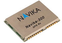
Accord has a Micro-i GPS SBAS receiver for this application using a chip-level receiver called the Navika-300, which comes from its Indian technology partners. Accord claims that the Navika is comparable to other chip-level receivers in the market from CSR (Sirf) and u-blox.
Topcon:
Topcon has partnered with MAVinci from Germany to market the Sirius Basic and Pro aerial positioning system in Europe, and presumably this system will find its way into everywhere that Topcon does business.
Achieving 5-cm GNSS-RTK accuracy without traditional Ground Control Points (GCP) increases productivity. Removing the need for placement of GCPs can potentially reduce time for a survey project by up to 50 percent. This precise positioning technology allows image locations developed by Sirius Pro to be used as the equivalent of GCPs.
Trimble:
The Trimble UX-5 Aerial Imaging Rover was probably first on the market as a GNSS/UAS system for precision surveying. Following the acquisition of Gatewing, Trimble has been working hard to bring a fully capable UAS surveying solution to market.
The Trimble UX5 aerial image data is processed into deliverables by the new Trimble Business Center (TBC) photogrammetry module. Specialized computer-vision algorithms produce accurate results automatically, with minimal manual interaction. The UX-5 provides a stable and reliable photogrammetric system delivering excellent results without requiring specialized photogrammetry knowledge or experience.
Trimble also unveiled a new high-performance integrated UHF receiver at the chipset level ( 60 x 55 x 15 millimeters), designed for OEM integrations, UAS among them. The BD930-UHF supports both triple frequency from the GPS and GLONASS constellations plus dual frequency from BeiDou and Galileo, making it ready to take advantage of additional signals as GNSS grows and grows. The BD930-UHF delivers quick RTK initializations for 1–2 centimeter positioning. It also has an advanced kalman filter PVT engine positioning in urban canyons and the like, for applications not requiring centimeter-level accuracy. The receiver also supports fault detection and exclusion (FDE) and receiver autonomous integrity monitoring (RAIM) for safety-critical applications — sure to become increasingly important in the FAA-ruled airspace and coming regulations.
The Trimble BD930-UHF high-performance integrated UHF receiver.
NovAtel:
NovAtel announced the release of the new OEM617D receiver at AUVSI’s Unmanned Systems 2014. The OEM617D is a compact, dual-antenna, dual-frequency, single-card receiver offering NovAtel’s ALIGN heading functionality and RT-2 Real Time Kinematic (RTK) GNSS positioning technology, in both dynamic and static environments. The OEM617D provides dual-frequency operation with GPS, GLONASS and BeiDou signals and also tracks Galileo, SBAS and QZSS, maximizing GNSS availability globally. Fixed and rotary-wing aircraft/UAS, marine, and autonomous ground vehicles will benefit by integrating the OEM617D as well as other applications requiring precise position and heading accuracy.
Gladiator:
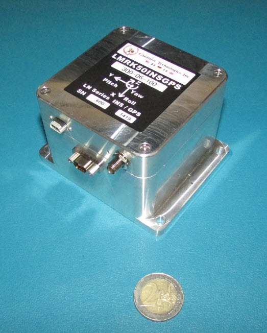
The Landmark 50 is a high-performance GPS/inertial product which comes in at the top of the Gladiator MEMS inertial product line. The LandMark 50 INS/GPS represents inertial performance on par with small ring laser and fiber-optic gyros. This performance leap with low-cost MEMS technology offers substantial improvement in performance utilizing the newest high-performance MEMS gyros and accelerometers combined with a 72-channel, 10-Hz update rate u-blox GPS, GLONASS, BeiDou, QZSS and SBAS receiver.
Geodetics:
Geodetics showed off a couple of new GPS/inertial products. The Geo-ReiNAV comes in both a commercial and a mil-spec (SAASM) version. As the team was at lengths to explain, Geodetics is GPS “agnostic” — which in today’s terminology means Geodetics uses a variety of OEM receivers in their products — the smarts are in the filter and processing. The other key component is a Seiko/EPSON G352/362 MEMS Quartz IMU, which apparently has less noise and lower drift (or more accurately “in-run bias stability”) than other silicon MEMS inertials.
Incidentally, we sat and discussed this material at the Geodetics booth, which seemed more spacious than in previous years — it was larger, as it spilled over into the next vacant booth which Hemisphere was supposed to have occupied — but having apparently reserved and paid, didn’t show up for the exhibition.
Sparton:
Sparton released news of the GAINS-10 Multi-GNSS assisted inertial navigation system at AUVSI this year. The unit excels in challenging environments. It provides accurate inertial navigation in the presence of mechanical shock, transient platform vibrations and extreme magnetic interference. The 10DOF IMU features high speed, synchronous sampling of all inertial systems combined with high rate coning and sculling compensation and is fully calibrated over temperature.
Vectornav:
The VN-300 is a miniature dual antenna GPS-aided INS system. The dual GPS adds heading determination, and the inertial aiding helps through potential GPS outages. A pressure sensor is also included for altitude determination. The VN-300 can be used in a wide variety of industrial and military applications and is well suited for size, weight, power and cost-constrained applications such as unmanned vehicle systems; antenna, camera and platform stabilization; heavy machinery monitoring; robotics; and primary or secondary flight navigation.
Oxford Scientific (OxTS):
Last year at AUVSI, Oxford introduced a miniature datalogging GPS/MEMS INS — this year it returned with the xNAV500, which is now real time. With dual GPS and antenna inputs, this unit also provides heading determination in a small form factor that is apparently very affordable.
MicroPilot:
One of the leading providers of autopilot systems for a large number of the UAS at the show, MicroPilot has not stood still during the last 12 months. The latest product addition is the MP2128³× triplex redundant autopilot using three high-performance 2128ɡ autopilot boards on one pcb. The advantage is that this autopilot is fault resistant, providing two additional back-up channels to resist critical function failure. A board-level option is available for integrators who want to combine functions in fewer on-board boxes.
UTC/Cloud Cap:
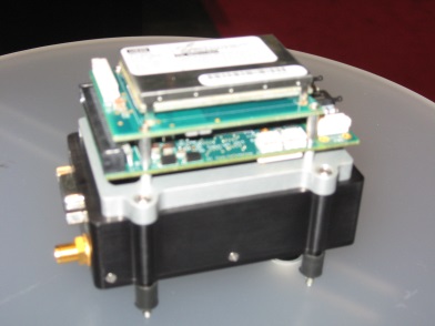
Cloud Cap is also one of the principle autopilot suppliers to the UAS industry. Cloud Cap appears to pack additional functions into its range of autopilots — including a core autopilot, flight sensors, navigation, wireless communications and interfaces providing data to the payload system. The Piccolo Nano is its smallest device, and has been mounted in a board stack on top of a Cloud Cap enclosure containing a NovAtel OEM615 used as the Nano GPS navigation source.
Overall on par with last year’s AUVSI conference in Washington, D.C., the Orlando venue probably encouraged more industry participation, but there seemed to be a lot fewer military people around. This probably accounts for what looks like reduced attendance over last year.
The GNSS/navigation exhibitors, however, were just as innovative as last year, and were present in good numbers. There was generally good traffic at most of these booths, so there are probably new customers coming directly from the show. What was the most notable new thing at the conference? For me, it was discovering the potential for a reduced scope of equipment certification — provided UAS could find a way to be included within the same class of aviation as balloons, micro-lights and gliders. This would really help bring more UAS with high-performance navigation into usable airspace — even unleashing the commercial potential that Congress and the industry need so badly.
Esri’s new Small Government Departmental Platform Agreement allows for unlimited deployments of core ArcGIS software within one governmental department. Departments that have plans to integrate GIS in multiple workflows — such as assessors, health and human services, public works, fire, and planning departments — can use this program to rapidly achieve their goals.
“Esri is always seeking to support departments that have a real vision for using GIS throughout their operations,” said Christopher Thomas, director of government markets, Esri. ”This program helps them get there faster.”
This program is designed for departments that want to:
increase ArcGIS software and Software as a Service (SaaS) deployments.
have flexibility when deploying GIS to desktops, servers, and mobile devices.
have a predictable annual licensing model.
The County of Tazewell, Virginia, population 45,936, was the first to participate. “This program has given the Tazewell County Engineering Department access to more tools and programs to help create and maintain better GIS data,” said Kenneth Dunford, assistant county engineer.
The Small Government Departmental Platform Agreement program is open to all governments in the United States with populations of 100,000 or less. For more information, call Esri at 800-447-9778.
Plimsoll Publishing is offering a new analysis, “GPS System Developers & Manufacturers,” which provides a detailed overview of the global market and delivers a comprehensive individual analysis on the top 100 companies, including Braemac (CA) LLC, Furuno Electric Co. Ltd. and Harman International Industries, Inc.
The report includes a wealth of information on the financial trends over the past four years. The analysis is aimed at anyone wanting to:
See the market leaders
Identify companies heading for failure
Seek out the most attractive acquisition
Analyze industry trends
Benchmark their own financial performance
Eighteen companies have a declining Plimsoll financial rating, while 12 have shown good sales growth. Each of the largest 100 companies is meticulously scrutinized in a one-page individual assessment and is analyzed using up-to-date and current financial data.
Every business is examined on the following features:
The Plimsoll Chart: A graphical assessment of a company’s financial performance
Four-year assessment of the profit/loss and balance sheet
A written summary highlighting key performance issues
Ubisense, a location intelligence solutions company, has become an Authorized Partner of solutions based on Google’s Enterprise Maps for Business technologies. This new designation from Google enables customers to more easily assess Ubisense’s expertise advising on and deploying Google products.
In conjunction with the partnership, Ubisense formally announced Ubisense myWorld 2.0, an intuitive location intelligence platform that integrates Google Maps for Business technologies and provides visibility into an enterprise’s operations, enhancing operational awareness and enabling businesses to operate more effectively.
Ubisense provides location intelligence solutions that address enterprise visibility challenges, and as an Authorized Partner, Ubisense can now provide Google Maps for Business integration and OEM licenses to its customers in a simple and cost-efficient manner. Ubisense myWorld brings critical enterprise information together into a single application that can be accessed via any standard web browser on any smart device. Ubisense myWorld incorporates network asset data, work orders, customer information, and other critical operational data from a variety of spatial and enterprise systems vendors. Additionally, Ubisense myWorld can be integrated with Google Maps for Business solutions, including Google Maps, Google Search, Google Earth, Google Elevation and Google Street View with Ubisense myWorld.
“Google Maps give our customers a smart, simple, and fast way to view complex business operations so they can quickly understand the state of operations and make better and more informed business decisions,” said Jay Cadman, vice president of business development, Ubisense. “In, say, an outage caused by a natural disaster, having this detailed view of an organization’s operations in real time enables our customers to respond to safety issues, such as downed power lines, with the right equipment and safety precautions the first time. They can keep their employees and customers safer and restore services faster. Every telecommunications and utility company in the world strives for that and now we’re able to deliver a solution that enables them to achieve both goals.”
Using Ubisense myWorld with Google Maps technologies, Ubisense customers can realize a number of benefits that can significantly impact an organization’s bottom line and improve customer service. Ubisense myWorld customers gain the ability to react to issues and potentially harmful situations sooner and are better prepared to solve issues faster, work more efficiently, and enhance their customer service and support. Rapidly gaining traction among telecommunications and utility companies, Ubisense myWorld is already used by 26 customers spanning five continents. Ubisense customers are using Ubisense myWorld for many critical business processes, including storm damage assessment, network operations, gas leak surveying, field mobility and customer service.
Google Maps for Business brings the power of Google Maps to an organization, providing simple, familiar mapping technology to the workplace. Users can layer their data on top of Google’s base map and create their own maps and geospatial applications that can be used by anyone — anytime, anywhere. By using any of Google Maps business solutions, including Google Maps Engine, Google Maps Engine Pro, Google Maps Coordinate or the Google Maps APIs, organizations and their employees can rely on maps that are comprehensive, easy-to-use and always up to date.
The Google Maps Partner Program includes companies globally that sell, service and customize Google Maps for business solutions for their customers. As a part of the Google Maps Partner Program, Ubisense receives training, support and deployment tools from Google.
Ubisense, a location intelligence solutions company, has become an Authorized Partner of solutions based on Google’s Enterprise Maps for Business technologies. This new designation from Google enables customers to more easily assess Ubisense’s expertise advising on and deploying Google products.
In conjunction with the partnership, Ubisense formally announced Ubisense myWorld 2.0, an intuitive location intelligence platform that integrates Google Maps for Business technologies and provides visibility into an enterprise’s operations, enhancing operational awareness and enabling businesses to operate more effectively.
Ubisense provides location intelligence solutions that address enterprise visibility challenges, and as an Authorized Partner, Ubisense can now provide Google Maps for Business integration and OEM licenses to its customers in a simple and cost-efficient manner. Ubisense myWorld brings critical enterprise information together into a single application that can be accessed via any standard web browser on any smart device. Ubisense myWorld incorporates network asset data, work orders, customer information, and other critical operational data from a variety of spatial and enterprise systems vendors. Additionally, Ubisense myWorld can be integrated with Google Maps for Business solutions, including Google Maps, Google Search, Google Earth, Google Elevation and Google Street View with Ubisense myWorld.
“Google Maps give our customers a smart, simple, and fast way to view complex business operations so they can quickly understand the state of operations and make better and more informed business decisions,” said Jay Cadman, vice president of business development, Ubisense. “In, say, an outage caused by a natural disaster, having this detailed view of an organization’s operations in real time enables our customers to respond to safety issues, such as downed power lines, with the right equipment and safety precautions the first time. They can keep their employees and customers safer and restore services faster. Every telecommunications and utility company in the world strives for that and now we’re able to deliver a solution that enables them to achieve both goals.”
Using Ubisense myWorld with Google Maps technologies, Ubisense customers can realize a number of benefits that can significantly impact an organization’s bottom line and improve customer service. Ubisense myWorld customers gain the ability to react to issues and potentially harmful situations sooner and are better prepared to solve issues faster, work more efficiently, and enhance their customer service and support. Rapidly gaining traction among telecommunications and utility companies, Ubisense myWorld is already used by 26 customers spanning five continents. Ubisense customers are using Ubisense myWorld for many critical business processes, including storm damage assessment, network operations, gas leak surveying, field mobility and customer service.
Google Maps for Business brings the power of Google Maps to an organization, providing simple, familiar mapping technology to the workplace. Users can layer their data on top of Google’s base map and create their own maps and geospatial applications that can be used by anyone — anytime, anywhere. By using any of Google Maps business solutions, including Google Maps Engine, Google Maps Engine Pro, Google Maps Coordinate or the Google Maps APIs, organizations and their employees can rely on maps that are comprehensive, easy-to-use and always up to date.
The Google Maps Partner Program includes companies globally that sell, service and customize Google Maps for business solutions for their customers. As a part of the Google Maps Partner Program, Ubisense receives training, support and deployment tools from Google.
Telenav’s free U.S. Scout for iPhone app will use the crowd-sourced and free OpenStreetMap (OSM) for all of its map data. OSM, the “Wikipedia of Maps,” offers users a more accurate and up-to-date map than what is available via commercial maps, the company said.
The rollout of OSM starts today for some Scout users and will be fully implemented for all users by the end of this week. The company plans to switch to OSM for Scout for Android in the U.S. in June. Scout’s companion website, scout.me, is already using OSM.
Telenav also announced today that through a rebrand of the popular skobbler GPS Navigation app for iOS and Android, Scout is now available in more than 50 app store markets with maps and navigation for almost 200 countries. skobbler’s GPS Navigation app was the first OSM navigation app in the world. Telenav acquired skobbler in January.
With this launch, Scout is supporting a growing community of global OSM editors. The OSM community has doubled year over year to more than 1.6 million registered editors, with people mapping every country around the world, ranging from the U.S. to Germany and Lesotho to North Korea.
The OSM crowd-sourced model enables edits to be published every minute, resulting in maps that are often more detailed and more up to date than commercially available maps. In addition to reporting traffic or accidents, now anyone using Scout can send mapping feedback directly from the app to Scout OSM editors who will let the person know once the data has been reviewed and updated.
“As a mapping platform, OSM is a credible alternative to proprietary solutions, with the added advantage of instant updates, resulting in a more accurate and up-to-date map,” said Steve Coast, founder of OpenStreetMap and Telenav’s head of OSM. “Roads change, subdivisions are built, and freeways expand so, just like all other maps, it needs updates on an ongoing basis. Today’s launch has effectively added millions of editors to the OSM global community, breathing even more life into an already exploding free and open-sourced project. Compare this to the billions of dollars that Google has spent — and will have to continue to spend — on keeping its maps updated and I think you can understand why we have switched to OSM.”
“This is a turning point for the mapping industry,” continued Coast. “The amount of effort and investment needed in order to provide high-quality turn-by-turn navigation using OSM crowd-sourced map data cannot be understated. We expect a significant return on our investments to create a better map platform for navigation using the free OSM. It took Telenav years of OSM community engagement, advanced algorithms, technology development, and road testing to reach a point where we felt it was ready for consumers. Now that we are here, we can’t wait for the world to try Scout with OSM. As for the global community of editors, this is true validation that their enthusiasm and passion for making a free, editable map of the world has made a dramatic impact on the evolution of maps and navigation.”
The OSM rollout is automatic for Scout users and does not require an app update. Separately, Telenav also announced today that it has launched a Scout Maps and Navigation SDK, the first GPS navigation SDK that allows mobile app and developers to integrate OpenStreetMap-based GPS navigation and maps within their own products. The new Scout for Developers program also includes a new Scout Maps API for desktop and mobile websites using OSM, allowing developers to replace Google Maps. More information is available at developer.scout.me.
Telenav is also sharing in the celebration of its OSM launch by kicking off a map-editing contest at scout.me/osmcontest where map editors have a chance to win various prizes including cash and tablets.
A flattened terrain surface model with 3D Vector features using Global Mapper.
Blue Marble Geographics has released Global Mapper version 15.2, a minor release that adds functionality to automate the New Feature Creation process, as well as the addition of new online datasources, including OpenStreetMap vector data links via Web Mapping Services (WMS).
Blue Marble’s geospatial data manipulation, visualization and conversion solutions are used worldwide by GIS analysts at software, oil and gas, mining, civil engineering, surveying, and technology companies, as well as governmental and university organizations.
The minor release features updates to both the Global Mapper base product and the Global Mapper LiDAR Module. In particular, new functionality has been added to allow the user to automate the New Feature Creation process. Users can now create a series of features that share the same attribute structure, target layer, and other characteristics without having to repeatedly confirm these settings in the Modify Feature Info dialog box. This release also features the addition of free online datasources including full access to the Maine GIS catalog, as well as access to Aviation Charts and OpenStreetMap vector data via WMS.
Other enhancements include support for creating buffer areas around line features with variable width from beginning to end and for creating buffers on just one side of a selected line feature. New scripting functionality has been added to allow conditional (IF/THEN/ELSE) processing within a script file. 3D models from Collada DAE files have been updated with the option to load BMP, JPG, PNG, and TIFF images with no geo-position information directly, improved 3DPDF support, and enhancements to CityGML.
“These great new features and functions will streamline the user’s workflow, as well as save them time and money with the ease-of-access to a growing list of cloud based publicly available data,” stated Blue Marble President, Patrick Cunningham “This release is another great example of our mission to deliver a low-cost and easy-to-use GIS solution for everyone.”
Enhancements to the LiDAR Module in v15.2 include added support for the transformation (shift/rotate/scale) of LiDAR point clouds and the option to filter selected LiDAR points to a certain elevation range and/or set of colors. A new LIDAR_CLASSIFY script command for classifying ground points in a script has been added. Users now have the option to keep the original file offset/scale, or to specify a new one when exporting to LiDAR LAS/LAZ files. They also now have the ability to crop to a selected area when specifying the bounds to import from a LiDAR point cloud and the ability to export point cloud to Esri File Geodatabases (GDB) as normal 3D point features. These LiDAR enhancements are a great addition to an already powerful module for those interested in adding advanced LiDAR functionality to Global Mapper.
Trimble is offering Field Link 2.20, the latest version of its software for management of layout tasks associated with building construction. The new release extends field layout capabilities for contractors and field teams, providing task-based workflows, customizable views, and a touch-screen user interface designed to optimize the information presented.
To find the exact location of a point in the field, users can now visualize where they are inside the 3D model relative to the layout point in their Trimble Field Link software, giving a more intuitive, realistic 3D perspective viewpoint and making it easier to navigate to the selected point.
Trimble Field Link Version 2.20 encompasses updates to Trimble Field Link for MEP and Trimble Field Link for Structures field software, which now include augmented 3D model support, and an enhanced in-model perspective layout view for a more productive and realistic field layout experience. Trimble Field Link also provides users with better visualization, navigation and rendering of building models, as well as the capability to import much larger, more sophisticated models.
In addition to the advancements made in performing layout-specific tasks, Trimble Field Link adds reporting routines to detail layout productivity, and the ability to document existing site conditions for information requests (RFIs).
Bentley Systems. Trimble also announced its collaboration with Bentley Systems to enhance information mobility between the design and field construction processes. This collaboration enables users to share their 3D constructible models between design and engineering applications and Trimble Field Link 2.20 via Bentley’s mobile i-model technology. A Bentley CONNECTIONS Passport, which entitles use of Bentley’s mobile apps and mobile i-models, is provided with Trimble Field Link.
Bentley i-models are containers for the open exchange of infrastructure information that enable project team members to share and interact with complex project data and across product lines and technology platforms. Using i-models, project teams can exchange and distribute packages of information within multi-organizational, multi-disciplinary, and multi-phase construction projects to continue uninterrupted workflows, and to easily adapt to real-time project changes.
“By joining forces with Bentley, Trimble is giving contractors and other building construction professionals greater choice, accuracy and flexibility in performing their field layout tasks,” said Mark Sawyer, general manager of the General Contractor / Construction Manager Division of Trimble Buildings Group. “Our companies share complementary visions of boosting productivity in all facets of construction projects, and we’re pleased to connect our advanced technologies to deliver greater benefits to the industry.”
HX Global’s new Travel Oracle mobile app provides an instant lifeline for business travelers and expatriate employees as well as access to critical information and support, before and during their travels, the company said. Key features include an instantly accessible Mayday call, automated personal tracking, online storage of all travel documents, instant news reports of unrest pushed to impacted travelers, e-learning travel security certification and destination profiles.
“Duty of Care requires that measures be taken to protect employees and Travel Oracle accomplishes that,” said Gregory Cain, president of HX Global. “Emergencies can strike at any time. On average, we airlift six medical emergency cases every day and respond to more than 450,000 assistance calls every year. The Travel Oracle app provides a safety net for employees and employers to provide protection for security issues and medical emergencies.”
“Traveler tracking systems have provided travelers and corporations with peace of mind over the years, but they have significant limitations,” said Dave Sarafinas, managing director and senior vice president of HX Global. “Travel Oracle overcomes those limitations by making traveler tracking personal and proactive. This new tool helps corporations provide end-to-end travel security.”
Travel Oracle leverages eLearning, live personal tracking and situational awareness to drive traveler empowerment. Combined with HX Global’s global capabilities and resources in the event of an emergency, a Travel Oracle traveler will be safer, and employers have the confidence that they have exceeded duty of care responsibilities. Key features include:
Emergency Call Function – calls are instantly sent to a 24/7 Command Center
Mayday Alert-Personal Tracking – alerts nominated contacts of traveler whereabouts via email, takes situational photographs, sends an audio recording and current GPS location, if pre-authorized
Online Personal Profile & Documents – online storage of travel documents and photographs
News Alerts and Live Support – global incident monitoring service with real-time country alerts sent directly to employee mobile devices. Access to 24/7 Emergency Assistance Helpdesk
e-Learning – travel safety courses, including certification upon successful completion
Country Profiles – comprehensive country briefings on over 200 countries including country risks and cultural differences
On April 1, Rohde & Schwarz joined the M2M Alliance, the largest association for the machine-to-machine sector.
“The advanced networking between people and machines and among machines themselves is completely changing our lives. It is opening up entirely new fields of application for our wireless test solutions,” said Jörg Köpp, who is responsible for the M2M/NFC market segment at Rohde & Schwarz. “With our commitment to the M2M Alliance, we want to promote this future-oriented technology worldwide.”
“We are very pleased to welcome Rohde & Schwarz to the M2M Alliance and gain a wireless specialist that has stood for quality and innovation in wireless communications technology for 80 years,” said Eric Schneider, first chairman of the M2M Alliance. “The company’s wireless test solution expertise and comprehensive portfolio make it an asset to the entire M2M industry.”
The reliability and security of mobile and wireless technologies are crucial to the success and acceptance of M2M applications. There are many industries where wireless applications have not previously played a role, but now even household appliance manufacturers, for example, are facing the challenge of integrating wireless components into their products. They need to verify that these components function correctly and obtain any necessary certification.
Rohde & Schwarz supports these users by providing T&M equipment for almost all mobile, wireless and positioning technologies, from LTE/LTE-Advanced, UMTS/HSPA(+), CDMA2000, Bluetooth and WLAN wireless Internet access to GPS/Galileo. Rohde & Schwarz also offers specific test solutions for eCall and vehicle-to-vehicle communications. Solutions for secure M2M communications and monitoring of associated networks round out the portfolio.
GPSTrackIt now offers Vehicle Diagnostics through its Fleet Manager dashboard to give fleet operators information about a fleet’s health in real time. The information is the same as that used by professional mechanics to identify why a check engine light is on.
Since 1996, vehicles sold in the United States have been equipped with an On Board Diagnostics (OBDII) port. Mechanics plug a handheld computer into the port to read the codes produced by the on-board computer. GPSTrackIt offers two ways to gain the benefits of vehicle diagnostics — with its new CP3000V plug-and-play device or the L2000V adapter cable.
The vehicle diagnostic codes received are used to determine the health of the various systems (ABS, Airbags, etc.) throughout the entire vehicle. In addition to the engine codes themselves, the system reports on a variety of indicators and parameters related to the codes.
“A key feature is that this engine diagnostic data can be used to trigger SMS text or email alerts,” said Eddie Bermudez, GPSTrackIt’s Product Development Manager. “These alerts would be sent to designated personnel. Being able to identify problems early helps reduce and often times eliminate costly repairs.”