Interview with Graham Purves, Executive Vice President, NovAtel
Graham Purves, NovAtel
GPS World (GPSW): In the regulatory picture for unmanned autonomous vehicles (UAVs), what are the concerns for the GNSS research, design, and manufacturing community regarding air-space regulation?
Graham Purves (GP): The main concern is the scope and impact of certification requirements for UAV navigation systems in the National Air Space. Certification places constraints on software complexity, so it is difficult to define solutions if the certification framework is unclear.
In the context of current avionics for civil aviation, design standards and certification requirements are well defined. In the case of pilot-less aircraft, the navigation systems may make use of additional features and technologies that are not part of the current certification paradigm. Examples are tightly coupled inertial navigation systems (INS) for flight control and redundancy, and real-time kinematic (RTK) and differential GPS for landing and capture. Certification requirements and design assurance levels for these features will have a major impact on the definition and design process, and may even prevent some effective technical solutions from being used, due to the software complexity. Of course, communications and communication standards will also present a significant hurdle.
GPSW: What are the concerns for the GNSS research, design, and manufacturing community regarding vehicle/road regulation for UGVs?
GP: Similar answer. The software used in positioning and navigation systems is significantly more complex than the safety-critical software in current automotive systems. Regulation for UGVs may result in restrictive certification requirements that affect or prohibit the use of more complex software. Until we have a clear understanding of the certification framework, it is difficult to define technical solutions.
GPSW: In looking forward to the Federal Aviation Administration tests at six sites for integrating unmanned aerial vehicles into the commercial airspace safely, what are some of the technical challenges that you (and presumably NovAtel’s partners) are facing?
GP: We have proven some excellent technical solutions in the non-civil applications and believe the main barrier is not a technical but a regulatory challenge.
GPSW: What other pieces/technologies do you have to pull into the UAV/UGV integration to make it work? Inertial, certainly. What else?
GP: The UAV/UGV application is a very interesting arena for other positioning technologies that either augment or complement GNSS. Apart from navigation and auto-pilot functions, we believe the sense-and-avoid functions will require other sensing technologies, like scanning lasers. When you include the mission-related functions that require precise steering, pointing and measuring systems, the UAV/UGV is a very exciting category for companies like NovAtel.
GPSW: Is UAV/UGV a game-changer for the GNSS industry? Similar to the cellphone/smartphone implementation of GNSS chips, which created a whole new sector?
GP: It does have two elements that might be considered game-changers:
The movement of GNSS and other positioning technologies into a safety-critical role. It seems inevitable that someday we will live in a world where autonomous vehicles are the norm, and the idea of having a human behind the wheel is both complex and unsafe.
The UAV/UGV is an enabling technology and a platform for innovation. Similar to the wireless revolution, the killer applications may well be things we haven’t yet conceived of.
Graham Purves has been active in the GNSS industry since 1990, starting in ASIC development and continuing with various technical and business positions within NovAtel over the last 26 years.
For some years now, we have been talking about GNSS interoperability. The concept has received so much careful attention at conferences, in R&D laboratories, in international working group forums, and behind closed high-level government and military doors, that one might understandably conclude that we have talked interoperability into existence.
Not quite. Not nearly. Not by the farthest, if measuring into the next decade constitutes far, reach of our actual, real-world grasp.
“If you can imagine it, you can achieve it.” William Arthur Ward, a professional inspirer of the 20th century, said that.
For nearly as many years now, we have been talking about GPS and GNSS backup. Similarly, the concept has undergone careful examination and much repeated (’til blue in the face) urging and warning and alarum-
sounding and planning and conjecturing and running through the halls of Congress. One might understandably conclude that we have conjured backup for critical infrastructure into actual, tangible, effective existence.
Again, not quite.
“Everybody talks about GPS backup, but nobody does anything about it.” Mark Twain said that.
April’s GLONASS downfall prompted distinguished industry leaders to again take up cudgels for multi-GNSS and for redundant PNT. They deserve and require our support, on all fronts, whether in the public arena, the lab, or the marketplace. But neither concept yet exists, truly and pervasively, that is to say effectively for all users.
When will reliable, robust, consistent and continuous positioning, navigation, and timing become a reality? Should we rely on whatever technology we currently possess until the perfect system comes available, or should we continuously upgrade at each iterative step along the way?
We take up this topic in our June 5 webinar, “How Much Farther to the Promised Land? Purchase Decisions in the Evolving Landscape of GPS, Multi-GNSS, and Alternative PNT.”
Four speakers will present:
a high-precision GNSS manufacturer,
a mass-market GNSS manufacturer,
an alternative PNT provider,
a design and manufacturing firm,
followed by questions from you, our audience. Come for a glimpse into the future, and estimations of its distance and time of travel from current location.
Among the key insights: technology changes too fast to wait until the next generation of a product to add new capabilities, when doing so risks loss of competitive edge or, worse, risks introducing a new product already obsolete. A mid-lifecycle component change can deliver both greater performance and cost savings. For details on this prior to June 5, visit the White Paper section of our website.
The North Sea fairly boils with GNSS activity recently. Trials of the eLoran back-up for GNSS, Galileo maritime trials, Brad Parkinson’s Protect, Toughen, and Augment sermon at the European Navigation Conference in Rotterdam, and also at that conference, the dramatic release of news concerning an even newer Loran system, enhanced differential Loran, that not only backs up GNSS in the event of disruption or jamming, but delivers 5-meter accuracy in the process. Imagine that — the back-up matching the first team in performance!
Durk van Willigen, René Kellenbach, and Cees Dekker of the Dutch consulting firm Reelektronika, and Wim van Buuren of the Dutch Pilots’ Corporation authored the ENC presentation about enhanced differential Loran, with results that greatly — and pleasantly — surprised many in the audience. A full technical article by these authors, describing the equipment, methodology, and test results of eDLoran, will appear in the July issue of GPS World. This column delivers a brief summary of the highlights.
The new Loran project arose from the need of harbor pilots responsible for bringing large and super-large freight ships into dock. These pilots require GNSS-level accuracies of 5 meters for such work, and all parties concerned — pilots, captains, ship owners, harbor management — need some form of robustness, that is, back-up for the GNSS systems in case of jamming, unintentional interference, system failure, or other disruption.
As extensive research had established that 5-meter accuracy cannot be met by the currently tested DLoran system, which cannot get better than 10-meter accuracy. Reelektronika developed a new differential Loran system called enhanced differential Loran, or eDLoran. A full prototype eDLoran system was built and extensively tested in the Europort (Rotterdam) area. The tests achieved accuracies of 5 meters.
For maritime applications, eLoran is considered as the most promising backup for GNSS in case the use of satellite-based navigation signals is denied. The Dutch Pilots’ Corporation askedReelektronika to investigate whether differential Loran could meet the pilots’ 5-meter accuracy requirement for a harbor navigation. This proved to be an enormous challenge as preliminary tests showed that even 10 meters was difficult to achieve with differential Loran (DLoran) as promoted by the UK’s Trinity House/General Lighthouse Authority (see item below about Harwich UK tests by GLA and ACCESS). The challenge had led to a thorough investigation of all possible error sources of a complete differential Loran system.
Differential techniques developed and implemented for Loran are comparable with differential GPS. Although the error sources of GPS and Loran are quite different, the major common error source in both systems is the lack of accurate propagation models.
This led to a new research project to find a more accurate differential Loran technique. All possible error sources have been investigated again where possible, which resulted in some unexpected results regarding accuracies and costs.
Enhanced Differential Loran: eDLoran
The new concept of differential Loran had to fulfill two important primary improvements. The first is a significant reduction in the latency of the data in the data channel; the second is that a large number of reference stations should be capable of receiving the data channel, without saturating the data channel. The simple conclusion was that Eurofix could not meet these two improvements. However, Eurofix is still the prime GNSS backup candidate for distributing accurate UTC over very large parts of Europe. Further, Eurofix has the capability to send short messages that might be encrypted for secure communication purposes which might then form a terrestrial backup, for example, Galileo PRS.
Instead of using the Eurofix channel, eDLoran uses the public mobile GSM (Global System for Mobile) network to send the differential corrections to users. eDLoran receivers therefore contain a simple modem for connection to the GSM network. The eDLoran reference stations are also connected to the Internet which may be implemented via a cabled access or also via a GSM modem.Fortunately, today many GSM networks are robust in respect of GPS outages.
The eDLoran infrastructure is not connected with any eLoran transmitter station and operates completely autonomously. An eDLoran reference station is connected to a central eDLoran server by its connection to the network.
eDLoran Results
Both static and dynamic tests have been carried out. Here, only the final result of the dynamic test is presented. For full details on both sets of tests, see the upcoming full-length technical article in the July issue of GPS World magazine.
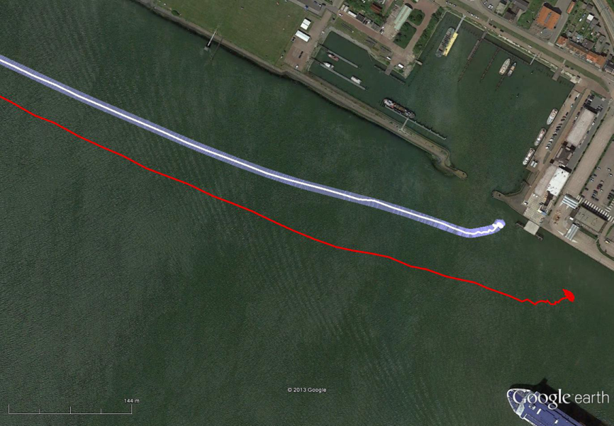
The results have been demonstrated to the harbor authorities in real-time on the laptop of the pilots on which the GPS-RTK and the eDLoran position were simultaneously shown. The logged GPS-RTK data is plotted on a Google Earth map shown in the accompanying figure. The track was widened to 10 metres as the accuracy requirements are 5 metres on either side of the track. The raw eLoran track is also shown, as well as the final white eDLoran track.
The red track is based on raw eLoran data without any corrections. The transparent blue line is made by GPS-RTK and is widened to 10 metres giving the required ± 5 metre limits of eDLoran. The white line is output from the eDLoran receiver which stays within the borders of the 10-meter-wide transparent blue line.
Conclusions
The outcome of the research opens some new and quite surprising possibilities for multiple applications. Only a few of the authors’ conclusions appear here:
eDLoran offers the best possible eLoran accuracy as it does not suffer from swaying wire antennas, sub-optimal timing control of the transmitter station and differential data latency.
There is no need to replace older Loran-C stations with eLoran transmitters saving large amounts of money. The existing Loran stations have a proven reliability track record. Further savings may be obtained by containerising the transmitter and operating the stations unmanned.
Installing eDLoran reference stations is fast, simple and very cost effective.
As there is no data channel bandwidth limitation, multiple reference stations can be installed which offers increased reliability and makes the system more robust against terrorism and lightning damage.
A single or multiple eDLoran servers can be installed in a protected area. There is hardly a practical limit in the number of differential reference stations to serve.
To round out our North Sea reporting, here is other recent news:
Enhanced Loran
In March, the UK General Lighthouse Authority (GLA) and Accessibility for Shipping, Efficiency Advantages and Sustainability (ACCSEA) announced that on several excursions aboard the THV Galatea out of Harwich, UK, they successfully demonstrated a prototype resilient positioning, navigation and timing (PNT) system using enhanced Loran (eLoran) technology to automatically and seamlessly step in to transmit mission-critical data in the event of GPS loss or failure. (Note that in the preceding Reelektronika section of this column, the GLA enhanced Loran is referred to as differential Loran, while the Dutch system is called enhanced differential Loran.)
Building on two previous trials conducted by the GLA in 2008 and 2010 which investigated the impact of GPS service denial, this latest demonstration is the first time that an automatic and seamless solution has been demonstrated in a real-world scenario. The prototype system was integrated into the bridge of the vessel and monitored the performance of independent PNT sources in order to provide the ‘best’ available. As such, when GPS was deliberately jammed, the system switched automatically to eLoran and provided eLoran-derived PNT information to the connected bridge systems, allowing them to maintain operation and enabling the mariner to continue to navigate safely and efficiently.
ACCSEAS is taking advantage of the availability of the prototype eLoran transmitter at Anthorn and eight other Loran stations around the North Sea Region, but few vessels currently have receivers. Most recently, in January 2013, a differential Loran station was installed at Dover, UK, one of the busiest shipping lanes in the world, enabling mariners to obtain port approach level accuracies using eLoran within this area; and a receiver was fitted on a P&O Ferries vessel. The successful demonstration of the prototype resilient PNT system is a significant step towards gaining traction for the technology in the shipping industry worldwide.
By 2014, eLoran Initial Operational Capability is expected in seven major ports along the East Coast of the UK, with full operational capability covering all major ports expected by 2019.
Galileo Maritime Trials
Results are being processed from the first Galileo maritime trials outside of mainland Europe. The long-range, high-latitude testing spanned the North Sea aboard Belgian frigate Leopold I-F930, carrying multiple Galileo receivers for both Galileo’s public Open Service (OS) and secure Public Regulated Service (PRS).
Protect, Toughen, Augment GNSS
“What can we do to reduce the vulnerability [of GPS] and ensure that the expectations of the public are going to be met?” asked Dr. Bradford Parkinson as he opened his keynote presentation at the European Navigation Conference, ENC-GNSS 2014 in Rotterdam, The Netherlands.
Parkinson went through his 61-slide, 50-minute briefing on what he called “PTA” — Protect, Toughen, and Augment — a proposal concerning not only GPS but PNT systems globally. An article by Parkinson based on this talk will highlight the special 25th Anniversary edition of GPS World, to appear in conjunction with this year’s July issue. A brief outline appears here.
The ESA Summer School is scheduled for July 21-31, at the Campus of the Technical University of Ostrava, Czech Republic. The school provides attendees with a comprehensive overview of satellite navigation, starting from the various GNSS, the signals, the processing of the observations in a receiver, and finally determining the position-navigation-time (PNT) solution.
Lab work will be carried out to give attendees hands-on experience. In addition, lectures on Intellectual Property Rights (IPR) and Patents, as well as on business aspects will be provided. The future of satellite systems will also be discussed. The main emphasis will be on the development of a group project using innovative ideas and covering all aspects, from the idea, business plan, and technical realization to the marketing of the product or service.
The program is open to graduate students (with a first university degree), Ph.D. candidates, early-stage researchers and young professional willing to broaden their knowledge. International renowned scientists and specialists will give the lectures as well as the practical exercises and lab work.
The following participants can register for the ESA Summer School:
Graduate students (more than 3 years studies)
Ph.D. students and postdoctoral researchers (< 35 years)
Young engineers and professionals from industry and agencies (< 35 years)
The number of participants is limited to 50. Early registration (reduced rate) is recommended (first come, first serve).
Geotab, a telematics engineering company, is announcing its J1939 integration launch with Mobileye’s Advanced Driver Assistance System — the Mobileye 560. In combining these two solutions, businesses with heavy-duty fleets will be able to use advanced warning alerts to reduce the likelihood of vehicle crashes from occurring.
In addition to the reports provided by Mobileye and Geotab that target unsafe driving practices, the solution also provides lane departure warnings, forward collision warnings, pedestrian and bicyclist warnings, distance keeping (headway) warnings, and speeding alerts. The ultimate goal is to give drivers added visibility and insight in the unexpected moments they need it most.
Edward Kulperger, VP of Business Development for Geotab, commented on the cooperation by explaining that “fleet management technology has evolved to include proactive and dynamic solutions that incorporate real time data in the vehicle and in a fleet’s operations to predict and alert both safety and efficiency elements of fleets.” Isaac Litman, Mobileye Inc.’s CEO, Mobileye Aftermarket, said, “With Geotab, we have provided businesses with an unbeatable driver monitoring and evaluation system. It is the one of the most effective risk management tools available in the marketplace today.” This enthusiasm was also mirrored by Neil Cawse, Geotab’s CEO, “The ease in which businesses can adopt this technology makes it possible for fleet managers to show real savings that make an impact on the bottom line.”
According to Mobileye, fleets using this collision avoidance technology typically realize a return on their investment in about 6-8 months. The benefits are abundant: Safe driving habits are significantly improved, costs associated with accidents are reduced or completely avoided, smooth driving patterns are reinforced on a continuous basis, and fuel and maintenance costs are minimized. Geotab and Mobileye are working together to bring the solution to the global market.
The Department of Defense announced that U.S. Air Force Space Command will begin broadcasting Civil Navigation (CNAV) messages on all operational GPS satellites capable of transmitting the L2C and L5 signals. L2C and L5 are the first of several new civil capabilities being added to GPS as part of the GPS modernization program announced in 1999. The L2C signal is designed to meet commercial needs and L5 meets safety-of-life transportation requirements.
“We have been working in partnership with the U.S. Department of Transportation (USDOT) to enable early delivery of two more civilian frequencies from the GPS satellite constellation,” said Maj. Gen. Robert E. Wheeler, DoD deputy chief information officer, C4 and Information Infrastructure Capabilities. “These new CNAV messages will enable manufacturers to develop and test advanced civil receivers and make for a more robust Position, Navigation and Timing (PNT) solution available to the civilian public. We do not anticipate any GPS satellite outages or legacy degradations as a result of the pre-operational deployment of these frequencies, and those currently using the GPS Standard Positioning Service should not be impacted,” he added.
The implementation will take place in two phases. First, on April 28, 2014, the initial broadcast of CNAV message-populated L2C and L5 signals will occur at a reduced data accuracy and update frequency compared to the legacy GPS signals in wide use today. Second, in December 2014, CNAV data updates will increase to a daily rate, bringing L2C and L5 signal-in-space accuracy on par with the legacy signals. However, derived position accuracy cannot be guaranteed during the pre-operational deployment of the frequencies. These pre-operational signals are primarily used to test various equipment and should be employed at the users’ own risk; not used for safety-of-life or other critical purposes.
The Air Force will broadcast L2C messages with the health bit set “healthy,” as was the case during a June 2013 test. L5 messages will be set “unhealthy,” but as greater experience with the L5 broadcast and implementation of signal monitoring is achieved, this status may change upon review. The public will receive ample notification before any decision to set the L5 health bit to “healthy.”
“The U.S. Department of Transportation is pleased with the collaborative effort and work of the CNAV tiger team, formed between the Office of the Secretary of Defense, Air Force Space Command, and the U.S. Department of Transportation, to address concerns about implementation of a pre-operational CNAV capability on the GPS L2C and L5 signals,” said Greg Winfree, assistant secretary for research and technology at USDOT.
For additional information about the testing, contact the Air Force Space Command public affairs office at 719-554-3731.
Trimblehas released a new GNSS-based machine control solution to improve efficiency of bulk earthworks and landfill compaction operations. Installed on a four-drum soil or landfill compactor, the Trimble CCS900 Compaction Control System allows a machine operator to make more uniform and efficient passes, report compaction production data in the field, and ensure target compaction is reached with minimal fuel usage and machine wear.
The announcement was made at WasteExpo 2014, North America’s largest solid waste and recycling tradeshow.
CCS900 for Bulk Earthworks. The CCS900 system tracks compaction passes in real time with easy-to-read color mapping on the in-cab display. It improves bulk earthworks operations by ensuring fill material is adequately balanced and uniformly compacted from the bottom up.
CCS900 for Landfills. Landfill operations require contractors to compact the maximum amount of waste into the smallest area of vertical and horizontal cell space. Using CCS900, landfill owners can ensure that cell space is optimized, voids are eliminated and layers are compacted to their target density more efficiently. With real-time mapping on the in-cab display, the operator can avoid unnecessary passes that waste fuel and cause additional wear on the machine. The system also collects as-built layer information for in-field reporting and tracking of daily volumes.
In-Field Reporting and Printing for Quality Control. For both soil and landfill applications, Trimble CCS900 offers extensive in-field reporting options, including in-cab report generation and printing. This functionality allows compaction production analysis to be carried out in the field instead of waiting until data is transferred back to the office. Compaction progress and problem areas are indicated on the in-cab graphical control box and listed in the in-field report so they can be addressed immediately, instead of at project completion when re-work is more costly. An optional serial printer in the compactor cab also enables supervisors to sign off on the completion of the compaction work in the field.
Supergeo Technologies, a provider of complete GIS software and solutions, has released SuperGIS 3D Earth Server 3.2 to assist enterprises in managing, integrating, publishing and displaying geographic data and 3D models.
SuperGIS 3D Earth Server 3.2 is GIS software designed to publish and overlay terrain data, 3D models, and so forth with spatial data, as well as to display the spatial data in 3D view. The GIS software can help users better explore geographic space and the spatial relation among data.
Integrating a cloud concept for straightforward data publishing and management, SuperGIS 3D Earth Server 3.2 allows users to easily distribute and deploy data. Administrators not only can effortlessly publish data as 3D map services over the Internet, but also apply browsers to access the published data, services, and websites without extra plug-ins.
Front-end users can directly view and manipulate the services in the 3D environment, including Query Feature, Position Query Results, and Share Screenshot. In this way, excellent interaction between users and maps can be obtained to further examine GIS-related problems to get best solutions for spatial issues.
Disy Informationssysteme GmbH, a provider of GIS and reporting solutions for spatial and non-spatial data, is offering a new app and service for offline maps for tablets.
GIS 2go allows users to save Esri’s ArcGIS Desktop maps to their tablets (iPad or Android). The GIS 2go add-in for ArcGIS Desktop supports data selection, map export and re-import via the cloud. With the app Cadenza Mobile GIS 2go installed on a tablet, users have immediate access to their maps, including all attribute data and media — even if they are offline in the field. Graphic notes and media created on the go can also be imported back into ArcGIS Desktop.
Users can interactively navigate on the map while on the go. Moreover, it is possible to show attribute data and use the graphic notebook to add points, lines and areas or track them via GPS. This information can be complemented with photos and audio/video recordings or text notes. Data captured on the go can be imported into ArcGIS Desktop and stored to the local database or file system.
How to save and use mobile maps on a tablet is described in 4 easy steps is at www.gis2go.com. The website also provides information on features and pricing, as well as tutorials and an FAQ.
A personal demo account is offered for interested users interesting in testing GIS 2go their mobile devices. The demo account is free of charge and without any obligation.
CSR plc and OriginGPS have announced a series of high- performance GNSS modules using CSR’s SiRFstarIV and SiRFstarV product lines.
The new modules are 70% smaller than current solutions and deliver a 30% reduction in Time To First Fix (TTFF), making them ideal for health and fitness trackers, sports watches, medical devices, wearable action cameras, and digital still cameras. All modules, including the newly released 7 x 7 millimeter Multi Spider (ORG4572) solution, integrate the LNA, SAW filter, TCXO, RTC crystal and RF shield.
“To accelerate market adoption of location technologies in wearable devices and cameras, manufacturers must minimize the embedded GNSS module size without compromising on performance, sensitivity, or power consumption,” said Anthony Murray, senior VP, Business Group at CSR. “By leveraging CSR’s industry-leading GNSS solutions and collaborating with OriginGPS on module development, we have achieved this objective.”
The OriginGPS modules offer high sensitivity resulting in shorter autonomous and aided TTFF, better navigation stability, and higher accuracy in harsh environmental conditions. In real-life testing of the module in camera applications, TTFF performance improves by over 30 percent compared to other solutions. The module also delivers TTFF results in less than one minute over 90% of the time (cold starts).
In addition to its small footprint, the GNSS module’s ultra-fast geotagging capability dramatically improves the consumer experience. The GNSS antenna module’s outstanding sensitivity and OriginGPS’ proprietary Noise Free Zone (NFZ) technology for faster position fix and navigation stability provides geo-tagging availability even under challenging satellite signal conditions such as low signal areas, under dense foliage, in urban canyons, and during motion-based activities. Battery life is considerably extended as a result of CSR’s breakthrough low power Push-to-Fix (PtF) technology, which rapidly establishes a valid position fix enabling the module to hibernate for longer periods of time. Push-to-Fix is an intelligent periodic low power mode that adaptively changes power depending on the operating environment and motion conditions. Advanced algorithms and a powerful on-chip DSP processor maintain high accuracy (QoS) while achieving the lowest power level possible for the given environmental and motion conditions.
“As the wearable technology and action camera markets continue to grow, we must ensure that our solution meets the market’s need for high performance and small form factor GNSS modules,” says Gal Jacobi, CEO of OriginGPS. “It is our privilege to partner with CSR and its excellent engineering team to meet the market’s need. CSR’s leading multifunction semiconductor platforms and OriginGPS’ miniaturized high performance modules create a unique value proposition for customers in these markets.”
OriginGPS modules are currently in mass production, and additional information can be found at www.origingps.com.
Tallysman Wireless, Inc., is offering a family of very low power, compact, high-performance GNSS antennas for precision, commercial, and military applications.
Based in Ottawa, Canada, Tallysman Wireless, is a designer and manufacturer of high-performance GNSS, Iridium, and Globalstar antennas and associated components.
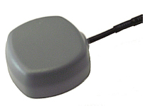
The TW4327 and TW4329 are low-power GPS L1 + GLONASS G1 antennas that feature current consumption of 1.75 mA typically and parametrically invariant performance over a supply range from 2.5V to 12V.
The TW4327 o ffers a 21-dB gain minimum, and the TW4329 includes a narrow pre-fi lter to prevent front end saturation by near out-of-band interfering signals.
Both antennas are more tolerant to detuning eff ects caused by the operational environment, thanks to a 40% thicker patch element that provides wider bandwidth than conventional antennas. These antennas are also very compact (38mm x 38mm x 14.4mm), making them ideal for use in a wide range of locations.
The TW4027 and TW4029 are equivalent antennas for reception of GPS L1 signals.
“These products are ideal for any battery operated applications where low power is a pre-requisite,” said Gyles
Panther CEO of Tallysman Wireless, “and the wider patch element bandwidth will minimize detuning in non-ideal
environments, such as in covert applications.”
Tallysman Wireless has recently added an authorized distributor of its products for Russia (Aurora Mobile Technologies), and another distributor for Asia (Advanced Information Technology, Inc.), for the countries of Vietnam, Hong Kong, Singapore, China, Indonesia, and India.
The two April failures in Russia’s GLONASS were caused by mathematical mistakes in software, according to Oleg Ostapenko, head of the Russian space agency Roscosmos.
Russian newspaper Ria Novosti reported on a press conference where Ostapenko said that programmers who had designed the satellites’ new software had made several mathematical mistakes, but the problem was not major and has practically been solved. “There were some mathematical mistakes, but they have been corrected,” he said.
Ostapenko said that the remaining problems would be solved by mid-May, and there is almost no chance of a similar failure happening in the future.