
Blog

  • Galileo Maritime Tests Followed Route of Viking Ships

    Galileo Maritime Tests Followed Route of Viking Ships

    Belgian frigate Leopold I-F930 in rough water off Norway during Galileo maritime testing. In December 2013 the frigate participated in the first maritime trials outside mainland Europe of the Galileo satellite navigation system.
    Belgian frigate Leopold I-F930 in rough water off Norway during Galileo maritime testing. In December 2013 the frigate participated in the first maritime trials outside mainland Europe of the Galileo satellite navigation system.

    Results are being processed from the first Galileo maritime trials outside of mainland Europe. The long-range, high-latitude testing spanned the North Sea, following the same historical sailing route that Viking dragon-ships used 1200 years ago.

    Ancient manuscripts record Viking navigators relied on “sunstones” to find their way — archaeologists believe these may have been polarizing crystals to pinpoint the Sun even in overcast skies.

    By contrast, Belgian frigate Leopold I-F930, participating in the end-of-year trials, carried the most up-to-date equipment possible, with multiple Galileo receivers for both its public Open Service (OS) and secure Public Regulated Service (PRS).

    “Galileo is in a transition between its In-Orbit Validation (IOV) phase and follow-on Full Operational Capability phase,” said Miguel Manteiga Bautista, head of ESA’s GNSS Security Office. “This means we are engaging in all kinds of experimental demonstrations of all Galileo services, in particular PRS, which offers the most highly accurate positioning and timing performance, but with access strictly restricted to authorized users.”
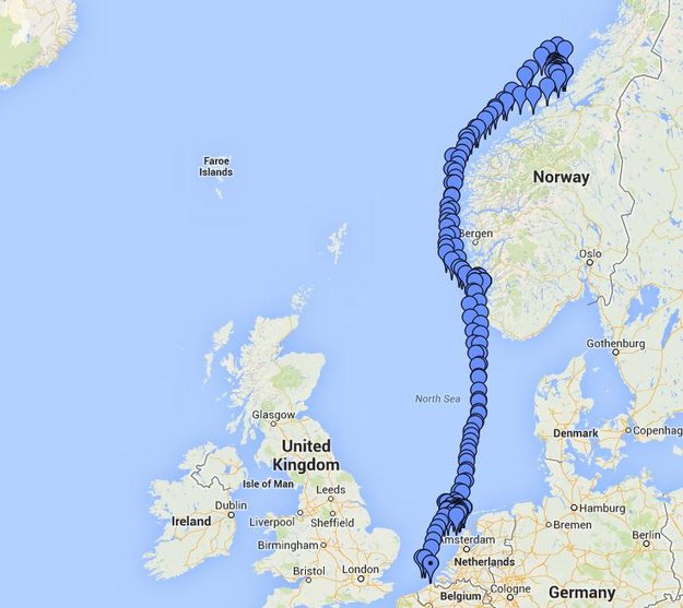
    The recorded course of Belgian frigate Leopold I-F930  during the first high-latitude trials of Europe's Galileo satellite navigation system. The frigate sailed first from the Dutch marine base of Den Helder on 4 December 2013 to Stavanger in Norway. From there it progressed north in very rough seas with 10-m high waves, coming close to the Arctic circle on December 17 — a first for Galileo PRS observations — before heading homeward.
    The recorded course of Belgian frigate Leopold I-F930 during the first high-latitude trials of Europe’s Galileo satellite navigation system. The frigate sailed first from the Dutch marine base of Den Helder on 4 December 2013 to Stavanger in Norway. From there it progressed north in very rough seas with 10-m high waves, coming close to the Arctic circle on December 17 — a first for Galileo PRS observations — before heading homeward.

    The frigate sailed first from the Dutch marine base of Den Helder on December 4, 2013, to Stavanger in Norway. From there it progressed north in very rough seas with 10-meter-high waves, coming close to the Arctic circle on December 17 — a first for Galileo PRS observations — before heading home.

    The testing provided tangible in-situ evidence of Galileo signal stability across both its operating frequencies up at high latitudes, equaling low satellite elevations in the local sky.

    Following the completion of earlier road, then flight, testing last summer and autumn, the last challenge for Galileo’s IOV phase was to engage in a long-term maritime trial into high latitudes. The testing was performed as part of the PRS Participants to IOV project jointly managed by ESA and the European Commission, in collaboration with the European GNSS Office Agency and several Member States possessing PRS test receiver technology.

    The trials were performed by the Royal Military Academy of the Belgian Ministry of Defence, the UK Space Agency in collaboration with Nottingham Scientific Ltd. and ESA, to ensure PRS signals were available whenever the four Galileo satellites in orbit came into view.
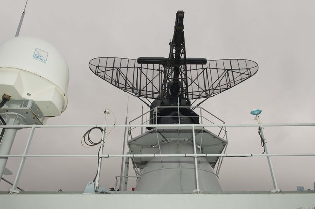
    Two receivers, seen either side of the main antenna, were carried by Belgian frigate Leopold I-F930 during high-latitude testing of both Galileo's publicly-available Open Service and secure Public Regulated Service in December 2013.
    Two receivers, seen either side of the main antenna, were carried by Belgian frigate Leopold I-F930 during high-latitude testing of both Galileo’s publicly-available Open Service and secure Public Regulated Service in December 2013.

    A dual-test setup was fitted to the frigate at Den Helder. Belgium connected a PRS receiver and an OS receiver, both manufactured in Belgium by Septentrio NV, to a common antenna. The PRS receiver recorded raw PRS measurements on both frequencies while the OS receiver logged data from openly available Galileo, GPS and GLONASS signals at one-second intervals.

    Nottingham Scientific installed its Ultra system configured to record radio-frequency samples, allowing the detailed post-processing of Galileo OS and PRS signals.

    “As this was a first use of PRS equipment outside EU borders, the security issues were quite challenging,” said Bruno Vermeire, head of the Belgium Competent PRS Authority (Federal Public Service of Foreign Affairs). “Several partners from different countries and industries were involved. At all times the necessary security was assured, though this could not have been possible without the dedicated joint commitment of all partners.”

    David Parker, head of the UK Space Agency, commented, “This test is a significant milestone on the road to demonstrating early PRS capability across a range of platforms. It should serve as a model for wider international collaboration between national governments and industry to prove and demonstrate PRS in different applications.”

    Belgian frigate Leopold I-F930 at Den Helder dockyard in the Netherlands.
    Belgian frigate Leopold I-F930 at Den Helder dockyard in the Netherlands.

    Alain Muls, professor of the Royal Military Academy of Belgium, faced the challenge of coordinating the maritime trial without interfering with the normal operations of the frigate. “Thanks to the cooperation of with the Maritime Component of the Belgium Defence, in particular that of the frigate’s commander and crew, preliminary results look very promising. Reception of Galileo’s OS and PRS navigation services have been practically demonstrated under severe maritime conditions with waves of up to 10 meters in height.”

    “This activity is a truly collaborative effort at all levels. The trial involved UK and Belgian governments and industry partners with support from different European bodies as well as officials from the Netherlands and Norway,” said Mark Dumville, Nottingham Scientific general manager. “This team effort has enabled the concept of radio-frequency sampling processing of Galileo PRS signals to be tested in real-world operational environments. We have confirmed that the prototype receiver is now ready to support European governments and associated PRS applications.”

    The collaborative nature of this trial was formally recognized as the Leopold I-F930 reached Stavenger. Under the supervision of Belgium’s CPA, Jochen Devadder, the country’s Ambassador to Norway Michel Godfrind provided a Norwegian delegation with details of the testing.

    Results from the trial will guide future Galileo developments for years to come.
  • Activation of Pre-Operational CNAV Message Set for April 28

    U.S. Air Force Space Command will be implementing CNAV messages on the GPS L2C and L5 signals beginning April 28 at 14:30 UTC, to facilitate user familiarization and development of compatible user equipment. No GPS satellite outages or degradations are planned. The L2C and L5 CNAV messages should be transparent to users.

    A 30-day public comment period on the pre-operational CNAV message ended April 4, apparently without enough concern to halt or delay the implementation.

    These pre-operational signals may not comply with all requirements, and so shouldn’t be used for safety-of-life or other critical purposes, Air Force Space Command said.

    Full text of the NANU appears below:


    Subject: New NANU 2014038
    NOTICE ADVISORY TO NAVSTAR USERS (NANU) 2014038 NANU TYPE: GENERAL
    *** GENERAL MESSAGE TO ALL GPS USERS *** The purpose of this notification is to inform users of an upcoming event related to the GPS satellite constellation.  Air Force Space Command will be implementing CNAV messages on the GPS L2C and L5 signals beginning J118/1430z with updates from the control segment approximately twice per week.  The message populated signal content will include Broadcast Message Types (MT) 10, 11, 12, 30, and 33.  There are no planned GPS satellite outages or degradations for this activity.  L2C and L5 CNAV messages should be transparent to GPS receivers that do not process L2C or L5 CNAV messages.  These populated signals are intended to facilitate user familiarization and development of compatible user equipment.
    NOTE:  Until further notice, the L2C and L5 signals are considered pre-operational. A pre-operational signal means the availability and other characteristics of the broadcast signal may not comply with all requirements of the relevant Interface Specifications and should be employed at the users’ own risk. Therefore these signals should not be used for safety-of-life or other critical purposes.  Any military or civil users who encounter user equipment problems following message population of the L2C and L5 signals should contact the applicable POCs identified below as soon as possible.  Aviation users should file reports consistent with FAA-approved procedures.
    *** GENERAL MESSAGE TO ALL GPS USERS ***
    POC: CIVILIAN – NAVCEN AT 703-313-5900, HTTP://WWW.NAVCEN.USCG.GOV
    MILITARY – GPS OPERATIONS CENTER at HTTPS://GPS.AFSPC.AF.MIL/GPSOC, DSN 560-2541,
    COMM 719-567-2541, [email protected], HTTPS://GPS.AFSPC.AF.MIL
    MILITARY ALTERNATE – JOINT SPACE OPERATIONS CENTER, DSN    276-3514,
    COMM 805-606-3514, [email protected]

  • Facebook Rolls out LBS Friend Finder

    Facebook Rolls out LBS Friend Finder

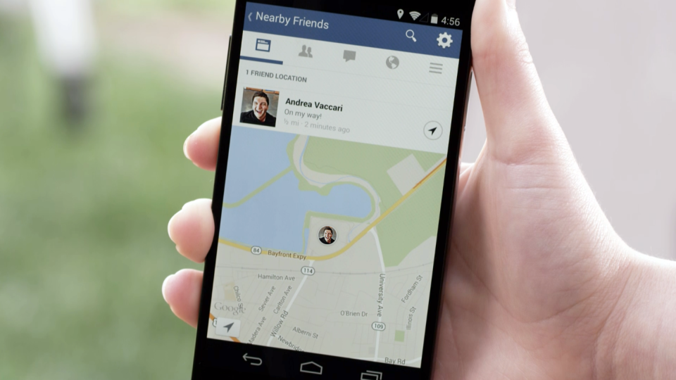
    Facebook Nearby Friends feature helps people get together.
    Facebook Nearby Friends feature helps people get together.

    While Facebook has made big news buying companies for billions of dollars, it hasn’t been making many location-based services headlines. The recent announcement that it is rolling out a friend finder is interesting news, not only for social applications, but the potential indoor positioning markets. The news is also interesting because as many as half of Facebook users access the social media network through mobile devices.

    Signaling that it does have a location strategy, as GPS World reported earlier this week, Facebook announced that it was launching an LBS offering called Nearby Friends. The opt-in service allows users to find out what friends are nearby or mobile.

    Nearby Friends will be available on Android and iPhones in the U.S. market this month. In Facebook’s press announcement, apparently privacy is a big issue as the company insists it is an opt-in function.

    Once users agree to use the service, they will be notified when friends are in close proximity. Users can select the friends who can see their location — and can turn the service on or off at any time.

    At first glance, Nearby Friends could be a valuable tool for users looking to find friends and make plans, but the real potential could be for retailers who wish to drive in-store traffic. Users can not only invite friends to a specific business on a map, but tag other traffic.

    The area or business to where the friends are traveling will be displayed on their profile. This allows the friends who opt in to recommend shops, restaurants and other things to do in the specified area.

    How retailers get their message out to Nearby Friends users remains to be seen. Research company Berg Insight still says advertising will constitute the main revenues for social networking and local search market segments. However, in several published reports, users have tired of the increased Facebook advertisements.

    Berg says that social networking and entertainment has now overtaken mapping and navigation as the largest location market. The company says that those services include general social networking, messaging apps, friend finders such as Nearby Friends, and games.

    While Facebook could use the Location History in Nearby Friends to make money selling ads, the company says it isn’t right now. But it has to be the future — and one that, privacy issues aside, could be very lucrative for the company. It could target opt-in users with ads that are only a few feet away or in the area they will meet friends.

    The Wall Street Journal reported that Facebook will leverage its user base, estimated at one billion users, to improve ad targeting, expand marketing reach, and to make more money. The company earned $1.24 billion in revenue through mobile ads for the last three months of 2013, according to published reports.

    After the announcement that Facebook was launching Nearby Friends, a number of tech business articles sprung up about potential, real and imagined, privacy issues. With the predictable privacy issues comes opportunities for location startups. A new location app is touting itself as the “anti-social networking” tool. Called Cloak, and available in Apple’s App Store, it allows a user to avoid friends they want to avoid by revealing the location of contacts — while keeping the user’s position hidden.

    The app, which already has been downloaded more than 100,000 times, uses Instagram and Foursquare data, and published reports say Facebook compatibility is coming soon.

    Rumors about Acquisition Prove False?

    Earlier this month, several tech business industry publications wrote that Israel-based indoor navigation startup ShopCloud was in talks with Samsung to sell the company for as much as $90 million. Samsung has denied the rumors.

    In articles like these, red flags always include terms like “several sources familiar with the details”. The price seemed high for a young company that hasn’t launched a product, though according to published reports, it has an app called Inside.

    One analyst says that the Israel tech business media frequently pumps up local companies and even creates buzz for startups — and often these reports are picked up by local journalists.

    Autonomous Vehicles Will Happen, but When?

    In January’s Transportation Research Board (TRB) meeting in Washington, D.C., attendees agreed that self-driving vehicles are the future. The bottom line is when is the future? “We have seen the business case for autonomous vehicles — it will be a reality. When you look at the number of lives it will save, efficiency of the network, it is very compelling,” said Kevin Link, Verizon senior vice president and general manager, China. “We have to begin a slow migration of educating consumers — one of those ways is through the connected vehicle. I don’t think consumers are there yet.”

    Link talked about autonomous vehicles at the Consumer Telematics Conference, also in January, but those at TRB are mainly academics and government officials, not business executives. Most believe it will take decades, Google car aside, to have a fully autonomous vehicle on the road. Others believe that if Detroit does not take notice, they can read about Google dominating this vehicle market, not being a player in it.

    In other location news:

    • Place, the Business of Location conference will be July 22 in New York. Executives from SK Telecom, Thinknear, Sonic Notify, Aisle411, and Factual will join Google, retailer Alex and Ani, and agency MEC North America (WPP), among others. The conference will include case studies and explore how mobile, offline tracking and indoor location will change the future of digital marketing and brand advertising. Many location conferences have died in the last two years, so it is refreshing to see a conference with a strong agenda back on the scene.
    • Finland-based IndoorAtlas rolled out an indoor mapping application for iOS. While iOS supports Apple’s iBeacon micro-fencing solution for indoor positioning, IndoorAtlas uses the compass chip built into smartphones and does not require external hardware such as Bluetooth beacons or Wi-Fi to determine location, the company said.
    • The U.S. Patent and Trademark Office awarded Apple a patent that could drive technology on the next generation iPhones. The patent describes a system that combines GPS, Wi-Fi access points, and on-board location databases to provide mobile devices positioning data in all types of environments, particularly indoor location.
  • Why Data from Automated Vehicles Needs Serious Protection

    Concerns about data privacy aren’t going away and, in fact, are growing. Many retailers that have adopted in-store tracking technology to enhance shopping experiences and gather information on customer behavior have met with backlash. Increasingly, people are turning to a new crop of apps to safeguard how personal information is used in other apps. We have apps to guard other apps. The world is getting more confused and scary. The Heartbleed bug and other threats have heightened concern about an even more threatening vulnerability of our connected world. So how will drivers feel about increasingly automated vehicles that generate huge masses of data of an exceedingly personal nature? What happens when it is hacked?

    Automated vehicles require multiple types of sensors to obtain information about the vehicle, its movement, and the surrounding environment, which includes the roadway, other vehicles, obstacles and infrastructure. All sorts of ambient information may be captured. Perhaps activity outside of your house, or your kids on their way to school, or the licenses of cars in your driveway will be caught on camera.

    The massive amount of data collected needs to be crunched, and only some of it will be processed within the vehicle. Other captured data will be sent off-board to the cloud for handling, with results then returned to the vehicle. The amount of data that will be created by automated vehicles is uncertain, but I’ve seen estimates of 1 GB per second. Whatever it is, it will be immense.

    What’s collecting data in a driverless vehicle? Lidar, a laser technology that uses reflected light, is identifying everything around the vehicle with great precision. Cameras are taking pictures to detect phases of traffic lights, identify stop signs, and map road lane markings. GPS is tracking the location of the vehicles and helping with navigation. Sonar is detecting objects and measuring their distance, speed and direction. And each vehicle is exchanging positioning, braking, heading and speed data with other vehicles on the road to prevent collisions.

    The data generated is both of a critical and personal nature. And data that is moving in and out of the vehicle to be processed elsewhere or to communicate with other vehicles is particularly vulnerable. The consequences are far greater than a violation of privacy or a stolen identity. The operation of vehicles is at risk to be maliciously disrupted to disastrous outcome. This isn’t an issue we can put off until driverless vehicles are closer in reach. Vehicles today are increasingly equipped with safety and entertainment features that capture critical or sensitive data, any of which could present a threat in the wrong hands.


  • Mobile Device Operating System Wars: Ver. 2.0

    It’s been two years since I wrote a column entitled Mobile Device Operating system wars: Android vs. iOS vs. Windows Mobile. After traveling and attending countless conferences and listening to a large number of mobile device users in the geospatial user community, I think it’s time to touch on this subject again, and what a crazy and confusing landscape it is. First of all, let’s frame the discussion in terms of the geospatial users, because that’s the soup we swim in.

    At the end of the day, we are driven by the geospatial software we use, so this limits the type of mobile device we can select from. For example, Esri’s ArcPad runs on Windows Mobile and Windows desktop. If that’s the software you want to use, then you can’t use an Android device, an iPad, or a Windows Phone device. In another example, AutoCAD 360 for mobile, which I used a few weeks ago in the field, runs only on Android and iOS devices, not on Windows Mobile devices.

    MobileOperatingSystems_2014

    Chart Source: The Wall Street Journal, Gartner

    While it appears Android is the dominant mobile operating system of the future, it depends on who you talk to. Right or wrong, some (maybe a lot of) enterprise organizations are scared of Android. They are scared because of one word: security, or more specifically, the perception of the lack of security. Android is open source, and it scares the heck out of enterprise IT (information technology) departments. It scares some to the point that they are shutting down projects that are proposing to deploy Android devices in the field. Is the fear justified? It’s probably more hyped up than it deserves, but IT folks are pretty conservative these days.

    Where does that leave the enterprise organizations? iOS or Windows?

    Some organizations are going with iOS, but the number of enterprise geospatial apps for iOS is very limited, and most of those that exist aren’t very powerful. They can’t even deal with datum transformations. That means the hardcore iOS enterprise users are left developing their own software, which some are doing. The other limitation of iOS is the hardware device selection. Since Apple doesn’t license iOS to anyone, you have the iPad and the iPhone and that’s about it. Not much selection.

    That leaves us where we started…Microsoft Windows.

    Dell Venue Tablet
    Dell Venue Tablet

    My gut tells me that Windows is making a comeback among geospatial users, even though Windows operating system market share is minuscule compared to Android and iOS on mobile devices. Part of the reason is a plethora of high-quality, Windows-based tablets and pads. Recently, I’ve had the chance to handle some Windows-based tablets such as Dell Venue tablet and Panasonic ToughPad. They are nice tablets for field use. Thank Apple for driving manufacturers to produce good quality tablets at a reasonable price. The other part of the reason, and the major driver, is security. IT departments simply trust the security features that Microsoft provides more than iOS and Android. In the age of security breaches such as the recent Heartbleed bug, the emphasis on computer security is at an all-time high.

    Panasonic ToughPad
    Panasonic ToughPad

    Security may be the catalyst that pushes Windows back into the forefront of operating systems for the enterprise geospatial user. That’s good news for geospatial software developers. Pressure has been mounting for geospatial software manufacturers to introduce Android- and iOS-compatible versions of their software. Now, with the security issue at the forefront and the availability of high-quality Windows-based tablets at reasonable prices, developers may have some breathing space.

    But wait: Which version of Windows?

    Windows Mobile? Windows Phone? Windows Embedded Handheld? Windows Desktop? Windows RT?

    They aren’t all the same, and they all don’t run the same software. For example, software built for Windows Mobile won’t run on Windows Phone or Windows Desktop.

    Microsoft’s mobile operating system strategy has been confusing at best. In past years, it’s been clear that mobile devices run Windows Mobile. It’s not so clear any longer. Microsoft discontinued mainstream support for Windows Mobile 6.1 and 6.5 in January 2013. It’s not as bad as it sounds because in the three years I’ve owned a Win Mobile 6.5 Pro device, an update was never issued. But what it does say is that Microsoft is done with it. No new devices will be designed with Windows Mobile 6.5. However, that’s not to say that Windows Mobile devices are going away. Microsoft just renamed it to Windows Embedded Handheld 6.5, which Microsoft says it will provide extended support for until January 2020. So, all is well, just a different name.

    Microsoft’s mobile strategy has turned off manufacturers, and it shows. Given that Microsoft has stopped supporting new devices running Windows Mobile since January 2013, how many devices have you seen introduced since then that support Windows Embedded Handheld? The answer is, not that many, and the ones that do support it are handhelds selling at a premium price, upwards of $1,500 or more. That’s tough to justify when you can buy a tablet or pad for equal or less. And…..the tablets and pads are running full Windows, not the mobile, handheld or phone version so they’re able to run a greater number of off-the-shelf software programs.

    Given the above, I feel the tide is turning, at least for the geospatial user community. Windows is going to make a comeback and be the go-to operating system for mobile devices, at least for tablet and pad devices. Don’t misunderstand me though: Android and iOS will still dominate the market share numbers by far, but that’s the consumer user community, not the enterprise geospatial user community. Windows Mobile devices will still have a niche place in the geospatial user community, but I have to wonder if software makers will continue to support that environment if the sales aren’t significant enough.

    Sidebar: For those of you who feel I’ve errantly left out the discussion about ruggedized devices vs. non-ruggedized or semi-rugged consumer devices, I’ll say this. Whenever I’ve encountered an enterprise that has deployed consumer mobile devices in an industrial environment (such as iPad), it invariably answers the question about device reliability with “We’ve had very few problems.” The reality seems to be that enterprise users are taking special care of these devices in the field. Program managers are saying, “Even if each person breaks one per year, it’s still half the price of industrial devices.” The reality is that small percentages are failing.

    However, one can’t ignore the outdoor usability issue. The displays on some consumer devices don’t handle sunlight very well, and if the display isn’t sunlight readable, the device is severely limited in the field. The same can be said for wide temperature ranges. Both extreme heat and extreme cold can torture a mobile device that isn’t built to withstand that environment. Test before you deploy. Heat it up in your oven, cool it down in your freezer, and see how it behaves.

    There’s certainly a niche market for ruggedized mobile devices, but the significant price difference between those devices and consumer devices are making enterprise organizations think twice about where to spend their money. Lastly, many consumer devices are trending towards semi-rugged as manufacturers are discovering this is one way to differentiate them from the ultra-price-competitive mobile device market.

    Thanks, and see you next time.

    Follow me on Twitter at https://twitter.com/GPSGIS_Eric

  • NovAtel CORRECT with TerraStar Service Now Available

    NovAtel Inc. announces that with the release of its 6.400 firmware, NovAtel CORRECT positioning technology is now available with TerraStar’s precise point positioning (PPP) corrections. Delivered via L-band, TerraStar corrections provide decimeter-level accuracy worldwide on all NovAtel OEM6 high-precision receivers, without users having to add base-station infrastructure. Subscriptions to the TerraStar correction service are available seamlessly to customers through NovAtel’s standard sales order process.

    NovAtel CORRECT optimally combines data from multiple GNSS satellite constellations with corrections from a variety of sources, to deliver the best position solution possible. The strategic importance of TerraStar’s decimetre-level correction service to NovAtel’s product offering is reflected in the recent purchase of TerraStar parent company Veripos by Hexagon.

    “The OEM nature of TerraStar’s correction service makes them a perfect partner for NovAtel,” stated Sara Masterson, New Business Development Manager for NovAtel. “We are extremely pleased with the performance of our current TerraStar offering and, with the ability to now work more closely together, we are very excited about developing positioning innovations for our customers in the future.”

    NovAtel CORRECT is available for land, air and sea applications, providing customers with one-stop shopping for receivers, antennas and correction services. It provides integrators with the opportunity to choose pricing and subscription options that best match their OEM business objectives.

  • Braxton LADO System Supports 10th GPS Satellite Initialization

    GPS IIF-5 was launched on February 20 and turned over to the 2nd Space Operations Squadron (2 SOPS) for operations on March 5. This was the 10th successful launch and initialization using Braxton Technologies‘ Launch, Anomaly Resolution, and Disposal Operations (LADO) system.

    LADO has performed all the mission planning, commanding and telemetry processing necessary to prepare all GPS satellites for operational use since October 2007. Developed and sustained by Braxton Technologies, LADO was built using Braxton’s ACE Premier commercial-off-the-shelf (COTS) product line for spacecraft control, astrodynamics and simulation.

    “Braxton is proud to be a key partner on the GPS program,” said Ken O’Neil, Braxton’s President and Chief Operating Officer. “As a small business, we greatly value our partnership with the US Air Force and enjoy quickly delivering innovative capabilities to support the U.S. military and the GPS worldwide user community.”

    The GPS IIF-5 replaces the GPS IIA-15 satellite launched in 1994. The 19th Space Operations Squadron (19 SOPS) will control the GPS IIA-15 using LADO, where the spacecraft will be stored as a spare available for reactivation within the x-plane for the remainder of its useful life.

  • GEOINT Coverage, Day 4: More clips from the Expo

    GEOINT 2013* — Day Four

    Here are more videoclips from the GEOINT Exposition Hall.

    VGo replicates a person in a distant location. A user can see, hear, talk and move around as if there. It was designed for healthcare staff such as doctors, and students or remote workers. Using VGo, an NGA staff member in Washington, D.C., was able to virtually attend the GEOINT Expo.

    LOGOS Technologies‘ KESTREL is a wide-area persistent surveillance sensor for aerostats to do real-time surveillance, day and night for continuous 360° intelligence collection. See the interview below, and a YouTube video of the system in operation.

    KESTREL in operation:

    There were numerous discussions by attendees about how the use of real location data and imagery could help greatly in  training and practice for real operations, providing a strong immersive environment.


  • Facebook Offers Nearby Friends Feature

    Facebook Offers Nearby Friends Feature

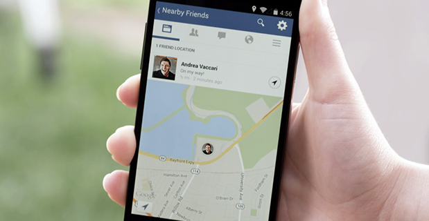
    Facebook Nearby Friends feature helps people get together.
    Facebook Nearby Friends feature helps people get together.

    Facebook has started rolling out a feature called Nearby Friends. Users can turn on the feature to help them discover which friends are nearby or on the go. When notified that a friend is nearby, the user can then get in touch or meet up.

    “For example, when you’re headed to the movies, Nearby Friends will let you know if friends are nearby so you can see the movie together or meet up afterward,” wrote Andrea Vaccari, Facebook Product Manager, in an article on the website.

    Nearby Friends is an optional feature. Users can choose who can see whether they are nearby (such as friends, close friends, or a specific friends list) and it can turned on and off at any time. Both the user and the friend needs to have the feature turned on and choose to share that information before notifications are sent.

    Users can also choose to share a precise location with particular friends for a set period of time, such as the next hour. The friend will see exactly the user’s location on a map, to help them meet up.

    Nearby Friends will be available on Android and iPhone in the U.S. over the coming weeks.

  • Omnilink Offender Monitoring and Asset Tracker Now on Verizon Network

    Omnilink, a provider of advanced machine-to-machine (M2M) tracking and monitoring solutions, has been named to the Verizon Partner Program as a Silver member.

    “U.S. government agencies, businesses, and consumers have depended on Omnilink to monitor the location, safety, and condition of offenders, assets, vehicles, loved ones, fleets, employees, and much more since 2004,” said Steve Hudson, Omnilink’s chief development officer. “We help businesses track and monitor virtually anything on almost any device, and set high standards in reliability, accuracy and ease of use. And now we are excited to make these solutions available to Verizon customers.”

    Omnilink FocalPoint Offender Monitoring is an advanced electronic monitoring solution that gives government agencies the ability to reliably track and monitor the location and status of their entire offender caseload across the U.S. on virtually any device. FocalPoint Offender Monitoring combines reliable GPS/AGPS/AFLT/RF hardware, the friendliest software, comprehensive 24/7/365 support services, and state-of-the-art-infrastructure for complete offender supervision.

    Omnilink Asset Tracker helps companies better manage their assets with an award-winning asset optimization, theft prevention, and monitoring and safety solution. Asset Tracker is an all-in-one asset tracking system that gives companies the ability to track and monitor the location and condition of all their physical assets—vehicles, trailers, equipment, retail, ATMs, bank bags, goods in transit, and much more — across the U.S. and beyond via their computer, tablet, and smartphone.

    The Verizon Partner Program tailors regional and national opportunities for systems integrators, value added resellers, agents and solutions providers to accelerate delivery and adoption of solutions for meeting medium business requirements. In addition, the program features a tiered benefits structure that allows members the flexibility to determine levels of commitment, and also includes simple-to-use tools and clear and consistent engagement processes.

    Verizon Enterprise Solutions creates global connections that generate growth, drive business innovation and move society forward. With industry-specific solutions and a full range of global wholesale offerings provided over the company’s secure mobility, cloud, strategic networking and advanced communications platforms, Verizon Enterprise Solutions helps open new opportunities around the world for innovation, investment and business transformation.

  • Supergeo Superior Public Bike System with SuperGIS Desktop 3.2

    20140416 Public Bike

    Chart: Supergeo Technologies

    Supergeo Technologies, a global provider of GIS software and solutions, is assisting Kaohsiung City, Taiwan, in analyzing  public bike system networks. SuperGIS Desktop 3.2 is helping administrators and citizens conveniently use the public transportation system for bicycles, the company said. Kaohsiung City has decided to provide its citizens with public bikes.

    Biking is a popular transportation method and personal leisure activity for the people of Kaohsiung City. Determining where to establish bike stops that will attract locals to use the bikes, without affecting the current busy traffic patterns, is the most important issue for administrators.

    The dilemma facing administrators is that bike stops shoud be near facilities, and the distance between each stop shouldn’t be too far. Through GIS technologies, decision makers can easily overlay the different layers that show diverse impact factors, such as nearby subway and train stations, and the most used pick-up and return routes.

    Also, SuperGIS Desktop 3.2 provides rich spatial analysis functions. With the buffer analysis, for instance, various factors can be analyzed and displayed so administrators can optimize the vehicle supplement.

  • Supergeo Superior Public Bike System with SuperGIS Desktop 3.2

    20140416 Public Bike

    Chart: Supergeo Technologies

    Supergeo Technologies, a global provider of GIS software and solutions, is assisting Kaohsiung City, Taiwan, in analyzing  public bike system networks. SuperGIS Desktop 3.2 is helping administrators and citizens conveniently use the public transportation system for bicycles, the company said. Kaohsiung City has decided to provide its citizens with public bikes.

    Biking is a popular transportation method and personal leisure activity for the people of Kaohsiung City. Determining where to establish bike stops that will attract locals to use the bikes, without affecting the current busy traffic patterns, is the most important issue for administrators.

    The dilemma facing administrators is that bike stops shoud be near facilities, and the distance between each stop shouldn’t be too far. Through GIS technologies, decision makers can easily overlay the different layers that show diverse impact factors, such as nearby subway and train stations, and the most used pick-up and return routes.

    Also, SuperGIS Desktop 3.2 provides rich spatial analysis functions. With the buffer analysis, for instance, various factors can be analyzed and displayed so administrators can optimize the vehicle supplement.