Spectra Precision has introduced the MobileMapper 20 GIS handheld. In the same form factor as the current MobileMapper 10 handheld, MobileMapper 20 offers enhanced capabilities: a new bright VGA color touch screen display, a 5-MP camera for higher resolution images, doubled memory capacity and 3.5G cellular performance.
The Spectra Precision MobileMapper 20 provides real-time GPS accuracy of better than 2 meters and post-processed accuracy of a half-meter using MobileMapper Office software. Mapping professionals can also take advantage of Spectra Precision’s optional MobileMapper Field software for data collection, maintenance and inspection.
MobileMapper 20 GIS handheld.
MobileMapper 20 incorporates a variety of communication technologies, including Bluetooth, Wi-Fi and a 3.5 G cellular modem, to keep mobile workers connected and more efficient while in the field. With a compact lightweight design, large display and long battery life (typically more than 20 hours), the easy-to-use handheld is ideal for intensive data collection. The MobileMapper 20 runs Windows Embedded Handheld 6.5 and offers the flexibility to support a broad range of third-party software applications.
“Building on the popular MobileMapper 10 handheld and responding to our customers’ evolving needs, we have significantly increased the power and functionality of our entry-level MobileMapper product portfolio,” said Olivier Casabianca, business area director of Trimble’s GeoInstruments. “With the introduction of MobileMapper 20, Spectra Precision is further extending the GIS capabilities of our customers in the field, while simultaneously providing them with the peace-of-mind of a standard two-year warranty.”
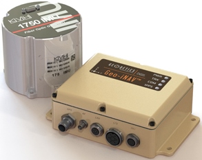
The Geo-iNAV Advanced is a fully integrated GPS-aided inertial navigation system that utilizes KVH’s 1750 IMU to provide a high-performance navigation solution.
KVH Industries, Inc., has entered into a strategic partnership with Geodetics Inc., developer of real-time, high-precision position and navigation solutions. The goal is to provide high-performance positioning and navigation products for commercial applications requiring high levels of precision, from unmanned platforms to terrestrial navigation.
Geodetics is integrating the KVH 1750 inertial measurement unit (IMU) into two solutions: Geo-iNAV Advanced, a GPS-aided inertial navigation system; and Geo-RelNAV, a high-accuracy relative navigation, positioning, and orientation system. The KVH 1750 IMU provides highly accurate 6-degrees-of-freedom angular rate and acceleration data, contributing to the high performance of the Geodetics products while also providing a commercial off-the-shelf (COTS) solution. The COTS designation means the Geo-iNAV Advanced system is available for commercial applications such as manned and unmanned aircraft and control, security platforms on land, air and sea, surface or subsea unmanned vehicles, mobile mapping systems, and photogrammetry and terrestrial navigation.
As reported April 9, NovAtel, Inc., has added the KVH 1750 as an inertial measurement unit (IMU) option in its SPAN GNSS/INS line of positioning products.
“Geodetics evaluated a number of IMU technologies, and based on our desire to address the needs of the commercial marketplace worldwide without sacrificing performance, we chose the KVH 1750 IMU, says Dr. Jeffrey Fayman, vice president, planning and development for Geodetics Inc. “With the integration of the KVH 1750 IMU in Geo-iNAV Advanced, you have the best inertial navigation system Geodetics can provide worldwide.” The navigation, position, and orientation accuracy of the Geo-iNAV Advanced is centimeter level, according to Fayman, thanks in part to the high accuracy of the KVH 1750 IMU.
“KVH is proud to have a strategic relationship with Geodetics,” says Jay Napoli, vice president, FOG/OEM sales at KVH. “The high performance of the 1750 IMU helps enable Geodetics’ systems to deliver ground-breaking accuracy while remaining available to the commercial marketplace.”
For navigation challenges such as collision avoidance and vehicle-to-vehicle navigation and communication (V2V), the Geodetics Geo-RelNAV system offers a highly accurate, real-time relative positioning and orientation solution that utilizes single- or dual-frequency GPS receivers and the high performance KVH 1750 IMU. The Geo-RelNAV provides precise relative position and orientation between moving platforms such as manned or unmanned air, marine, and ground vehicles. This relative position data is used for such applications as autonomous aerial refueling, autonomous landing, and collision avoidance.
KVH is one of the only fiber optic gyro manufacturers to control the entire production process, from creating its own specially designed polarization-maintaining optical fiber to packaging its gyros together in advanced systems for inertial measurement, inertial navigation, and attitude heading and reference systems. As a result, KVH’s inertial sensors and gyros offer outstanding accuracy and excellent durability at a lower cost than competing systems.
Spectracom, a business of the Orolia Group, has extended its global service capability through a partnership with EZU Technologies. Joining Spectracom service centers in North America and Europe, EZU Technologies will support Spectracom users throughout the Asia-Pacific region from its facility in Hong Kong. Initially, services will include equipment calibration and repair services. Over time, more capability will be added to deliver Spectracom’s full range of services in the region.
Spectracom’s portfolio of GNSS signal management solutions include a variety of services to ensure their customers gets the most out of their application for positioning, navigation and timing. “We understand our customer’s needs for fast access to services. Our strong growth in Asia, particularly for GNSS simulation and enterprise-class timing, will be supported by localizing services in the region,” said Thierry Delhomme, general manager, Spectracom Europe.
This new service center is the first of several partnerships to deliver global services in support of Spectracom solutions. Lisa Withers, Spectracom President and CEO, said, “We are pleased to expand our existing partnership with EZU Technologies to develop a regional service hub. This will enhance the local service provided by our strong set of local distributors and resell partners throughout the region.”
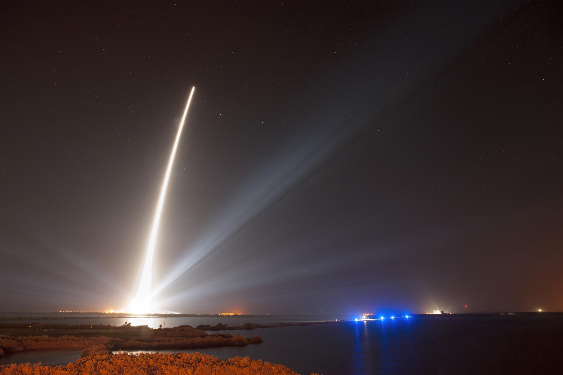
A United Launch Alliance Delta IV lifts off from Space Launch Complex-37 with the Air Force’s Global Positioning System (GPS) IIF-5 satellite. This launch marked the 25th Delta IV flight since the first flight in 2002.
The latest GPS Block IIF satellite, IIF-5 or SVN64 (operating as PRN30), was launched on February 21, 2014. Typically, GPS satellites are checked out and made operational within about a month following launch. SVN64 has yet to be set healthy.
The delay is due to an extended navigation test being performed by the GPS master control station. A navigation upload for SVN64 was performed in March with ephemeris and clock data as usual streching weeks in advance. However, unlike with operational satellites, no further updated uploads have been performed. The aging ephermis and clock data gradually becomes less and less accurate as time goes by but should degrade gracefully.
Inquisitive observers will have noticed that the received navigation data from SNV64 changes infrequently. Currently, the navigation data changes once per day with an epoch of 13:00 GPS Time unlike every two hours with operational satellites. And the data fit interval is 26 hours, compared to four hours.
Roy Nelson of Ball Aerospace discusses real-time 3D models created with flash LIDAR. See video below.
GEOINT 2013* – Day Three
I had the opportunity to interview Keith Masback, CEO of USGIF, about GEOINT 2013*. He discusses new technology, future combat systems, and plans for the 2015 conference. Watch the interview here:
I spent a good part of the day touring the GEOINT EXPO. Here are a few video clips that show technology I found especially interesting, from these exhibitors. (Scroll down to see each video.):
Ball Aerospace: Roy Nelson of Ball Aerospace discusses real-time 3D models created with flash LIDAR.
Consolidated Resource Imaging (CRI): Dr. Gregg Wildes discusses the company’s system of wide-area surveillance, including the WAMI, or wide-area motion imagery system.
Solid Terrain Modeling: Mark Fisher talks about how his company creates 3D models of terrain using geospatial data sets with its special inkjet printer.
TerraGo: Scott Lee shows off new developments with GEOPDFs on a mobile device, using the Terrago Edge application.
Thermopylae Sciences & Technology: Jamel Monroe, engineer at Thermopylae, demonstrates the Occulus Rift 3D virtual reality glasses, with the game Half-Life 2.
Art Kalinski, Geointelligence Editor, interviewed USGIF CEO Keith Masback about GEOINT 2013*, being held this week in Tampa, Florida. Mossback discusses new technology, future combat systems, and plans for the 2015 conference. Watch the interview above.
Kalinksi has been reporting from GEOINT* 2013 all week, with video reports. His coverage of Day Three includes visits with experts at six booths in the exhibit hall, including a demonstration of the Occulus Rift 3D glasses and an inkjet printer that produces 3D terrain models, as well as an interview with USGIF CEO Keith Mossback about the show and plans for next year.
Coverage of Day Two includes a press briefing with Lettitia Long, director, National Geospatial-Intelligence Agency (NGA); a demonstration by Airbus; and a visit to the Skyline booth.
Read his coverage of Day One of the symposium here. Included are videoclips from a DigitalGlobe presentation about the TomNod crowdsourcing efforts to find Malaysian Airlines Flight 370.
Streamer map of the conterminous United States showing water basins, weather radar, and real-time streamflow stations.
Field & Stream called it a “…very cool tool and quite a bit of fun.” MinnPost described it as a “…high-tech illustration of Norman Maclean’s timeless view that, ‘Eventually, all things merge into one, and a river runs through it.” And Popular Science noted that, “There’s something especially satisfying about clicking a stream that…shoots its way across multiple states to empty into the ocean.”
These publications are all describing Streamer, the popular on-line mapping program from the U.S. Geological Survey. Streamer is a powerful, yet easy way to explore our major waterways. With a simple map click, anyone can trace rivers and streams from a starting point all the way downstream to where a stream drains. Even more impressive, they can click on a stream and trace all others that drain to that point. Streamer also produces a report that includes a map and information about the people and places encountered along the streams traced.
Streamer map of an upstream trace from a point on Belle Fourche River in South Dakota extending into Wyoming and Montana. Weather radar and real-time streamflow stations are shown on the map.
As good as Streamer was when it launched last summer, it just got better. Four major enhancements and dozens of small improvements have been made. These include:
A new map layer displays the locations of real-time streamflow stations across the country. Streamer updates this information hourly and symbolizes these stations to illustrate current streamflow conditions compared with each station’s observed mean streamflow on the same day of the year.
You can tell at a glance whether conditions are above, below, or at normal levels at each station.
Links are provided from Streamer directly to selected stations for additional information and data.
Another new map layer has been added that shows weather radar across all 50 States.
Useful improvements to Streamer’s detailed reports have been added. One of these lists the names of waterbodies (lakes, reservoirs, etc.) along the path of your trace.
Congressional Districts encountered along your trace have been added.
A mouse click takes you from the Streamer report to additional information from the Census Bureau about socioeconomic conditions in each District.
Searching for locations on Streamer’s map by place name, zip code, geographic coordinates and more is greatly enhanced.
In its first eight months in service, Streamer users traced more than 2.9 billion river miles.
The USGS announced in February that it is ending production of the National Atlas on September 30, and that some of its products and services would transition to The National Map. With this release, Streamer becomes the first of these National Atlas products and services that The National Map will offer. For cartographers and geospatial information professionals, Streamer’s surface water data is available for download at no cost.
Detail from a Streamer map of an upstream trace from a point on the Arkansas River near Geuda Springs, Kansas, extending into Colorado and New Mexico. Real-time streamflow stations are shown.
Streamer map of the conterminous United States showing water basins, weather radar, and real-time streamflow stations.
Field & Stream called it a “…very cool tool and quite a bit of fun.” MinnPost described it as a “…high-tech illustration of Norman Maclean’s timeless view that, ‘Eventually, all things merge into one, and a river runs through it.” And Popular Science noted that, “There’s something especially satisfying about clicking a stream that…shoots its way across multiple states to empty into the ocean.”
These publications are all describing Streamer, the popular on-line mapping program from the U.S. Geological Survey. Streamer is a powerful, yet easy way to explore our major waterways. With a simple map click, anyone can trace rivers and streams from a starting point all the way downstream to where a stream drains. Even more impressive, they can click on a stream and trace all others that drain to that point. Streamer also produces a report that includes a map and information about the people and places encountered along the streams traced.
Streamer map of an upstream trace from a point on Belle Fourche River in South Dakota extending into Wyoming and Montana. Weather radar and real-time streamflow stations are shown on the map.
As good as Streamer was when it launched last summer, it just got better. Four major enhancements and dozens of small improvements have been made. These include:
A new map layer displays the locations of real-time streamflow stations across the country. Streamer updates this information hourly and symbolizes these stations to illustrate current streamflow conditions compared with each station’s observed mean streamflow on the same day of the year.
You can tell at a glance whether conditions are above, below, or at normal levels at each station.
Links are provided from Streamer directly to selected stations for additional information and data.
Another new map layer has been added that shows weather radar across all 50 States.
Useful improvements to Streamer’s detailed reports have been added. One of these lists the names of waterbodies (lakes, reservoirs, etc.) along the path of your trace.
Congressional Districts encountered along your trace have been added.
A mouse click takes you from the Streamer report to additional information from the Census Bureau about socioeconomic conditions in each District.
Searching for locations on Streamer’s map by place name, zip code, geographic coordinates and more is greatly enhanced.
In its first eight months in service, Streamer users traced more than 2.9 billion river miles.
The USGS announced in February that it is ending production of the National Atlas on September 30, and that some of its products and services would transition to The National Map. With this release, Streamer becomes the first of these National Atlas products and services that The National Map will offer. For cartographers and geospatial information professionals, Streamer’s surface water data is available for download at no cost.
Detail from a Streamer map of an upstream trace from a point on the Arkansas River near Geuda Springs, Kansas, extending into Colorado and New Mexico. Real-time streamflow stations are shown.
Spirent Communications today introduced the GSS6300M range of multi-channel GPS and multi-GNSS simulators for receiver integrators, application developers, aftercare and production testing environments. This entry-level test system readily enables laboratory evaluation of GPS performance across different locations and routes, Spirent said. In addition to being easy-to-use even for non-GPS experts, the GSS6300M range features competitive pricing for engineering teams looking to integrate positioning functionality to new classes of consumer electronic devices.
The GSS6300M is a “one-box” solution with everything required to start testing immediately and can be controlled from a tablet or smartphone, or via remote commands across multiple interfaces. It enables a variety of fundamental test and compliance to industry standard. Users can create custom trajectories using a Google Maps interface to help evaluate receiver performance.
The GSS6300M offers the same preeminent signal quality as other Spirent test systems, which are used by governments and space agencies around the world. High fidelity test equipment ensures the highest user experiences, leading to improved customer satisfaction, reduced product returns and greater market success for integrators and application teams.
“Positioning is of key importance to a wide range of new applications and consumer devices. As navigation and GPS test experts, Spirent wants to help developers build high-performing positioning functionality into their systems quickly and easily,” said John Pottle, marketing director of Spirent Positioning Technology. “Spirent provides test equipment that our customers rely on to achieve accurate results they can trust. The GSS6300M continues this tradition and is priced to be widely accessible.”
The GSS6300M is designed to for the huge and growing range of applications and technologies that incorporate location features — from vehicles and mobile devices to wearable technology, security tracking and other new market segments. In addition to GPS, the GSS6300M fully supports GLONASS, BeiDou and Galileo, the Russian, Chinese and European navigation systems.
From a weather perspective, Aberdeen, Scotland, may not be the most inviting location in the world in which to live. Nevertheless, Aberdeen is the leading European oil & gas business hub and is one of eight “super cities” spearheading the UK’s economy. But it’s waaaaay up north of the border with England on the east coast of Scotland — winter conditions can be difficult, even inhospitable at times. But if you want to transmit differential corrections out to shipping and oil rigs in the North Sea, it’s an ideal location.
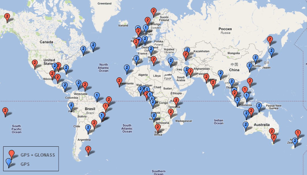
Since its first beginnings in Aberdeen, Veripos has evolved to become a major worldwide business for marine, and now also for “precise land navigation, positioning and guidance solutions.” Veripos is now delivering augmentation services on a global basis, employs more than 130 specialist personnel based in 11 sites around the world, and in 2013 had revenues of more than $45 million. With a global ground network of more than 80 dual-redundant receiver base stations, Veripos now provides not only traditional differential GNSS transmissions, but also precise GPS and GLONASS orbit and clock corrections over seven Inmarsat GEOs and also via the Internet — we now call Precise Point Positioning (PPP).
Veripos ground receiver station network.
Veripos began in March 1989 as a joint venture between Brown & Root Survey and Ormston Technology, a specialist marine electronics company based in Hull, England. Initially, Veripos provided a conventional Differential Global Positioning Service (DGPS) for users in the North Sea based on HF radio transmitters.
Introducing a much broader satellite-based DGPS service in 1994, coverage was extended to cover the Gulf of Mexico followed by further expansion of the network/coverage into Brazil, West Africa, Mediterranean and Caspian Sea. Veripos became a wholly-owned subsidiary of Subsea 7 in the same period. Following a major expansion in late 2004, full global service coverage was achieved in 2005, and ultimately Veripos became the second largest precise satellite positioning services supplier in the world to the marine industry, with leading clients in exploration, seismic, construction, survey, offshore supply vessels (OSV) and offshore drilling. In late October 2012, Veripos diversified further, launching its TerraStar business to address the land and near-shore sector.
Achieving global accuracies of 5-10 centimeters using relatively small amounts of data, users worldwide are mostly able to accommodate the initial convergence time needed to achieve these higher accuracies. Veripos claims that using multiple constellations, convergence time can be down to less than 10 minutes — even lower for hot starts.
The “free” IGS data that competes with Veripos and other subscription correction providers is also pretty good, but it’s not generally used by commercial operations.
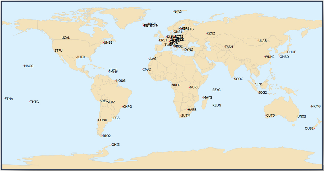
IGS Multi-GNSS Experiment Tracking Network.
IGS data is provided by academic and government sources around the world, and the advantage is not only free access, but also open data and multiple open-source software tools and data, all built to published open standards. But the IGS system is not a 24/7 reliable data source, and support can be a problem. It’s not designed for companies who must have service guarantees in order for them to consistently operate profitably in difficult conditions — it’s more experimental, for research and testing for the academic and government outfits that produce the data, along with a whole bunch of engineering teams who take advantage of free data and can cope with system hiccups for their R&D and for comparison purposes.
So Veripos and other commercial providers overcome the weaknesses of IGS by providing a worldwide network that is well maintained — an infrastructure designed for high reliability and availability. Each base station has dual-redundant receiver and communications links. There are three processing centers, two active and one on warm standby, that can each operate the whole system, and each of the processing centers has dual-redundant equipment. There are seven geostationary satellites with a large degree of coverage overlap, and Internet data feeds also provide a backup. More than these system design features, Veripos works directly with its customers to ensure successful integration of their corrections with customer operations and, above all, supports the customer directly during these operations. If the customer is not operational, Veripos recognizes that down time means lost profits for its customers, so its staff work hard to avoid any service interruptions.
It’s not clear what would happen to this currently stable marketplace if and when Galileo begins selling a commercial service on E6, but the existing commercial service providers are pretty sure that competition in their segment from a government provider that is publicly funded is not in their best interests. At the recent Munich Satellite Navigation Summit, Gian-Gherardo Calini from the European GNSS Agency certainly received a clear message from Trimble, NovAtel, Veripos and Fugro (to a lesser extent) that these companies do not believe that Galileo should be entering their market. However, Calini did state several times that the GNSS agency did not want to disrupt this market. How to do that when the Galileo infrastructure, control systems and satellites are wholly government funded remains unclear. Even if the service were wholesaled to a commercial provider, it’s unlikely that the retailer would have to bear the full cost of maintenance and support of the entire Galileo ground and space infrastructure, so their service would in effect be hugely subsidized.
Veripos recognized that focusing on its marine service alone is ignoring the land segment. So the company established a new business called TerraStar to address the land segment, just as Fugro had spun off OminSTAR for the land segment many years ago. TerraStar is still a division of Veripos, and the PPP infrastructure and distribution system it uses is the same. TerraStar is focused entirely on land and close-to-shore operations, so its business development and marketing is aimed at wholesaling its services through OEMs for these segments, while Veripos continues in parallel solely with marine and offshore.
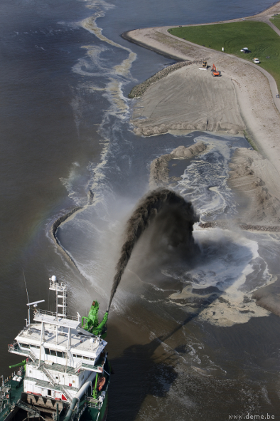
Initial OEMs to sign up were Septentrio and Altus, which is a subsidiary of Septentrio that focuses on survey products and applications. Septentrio had a number of successes with DEME dredging and land reclamation in Belgium and terrascan airborne geophysical survey in South Africa and Germany.
Terrascan airborne geophysical survey.DEME land reclamation.
And here we arrive at the place where these companies all start to come together. In mid-March this year, Hexagon acquired Veripos, along with TerraStar. Hexagon is, of course, the parent that has NovAtel and Leica in its thoroughbred stable of GNSS industry leaders. Could this acquisition have something to do with John Deere/NavCom operating its own StarFire PPP system, or Trimble acquiring OmniSTAR from Fugro and now providing its own range of PPP correction services?
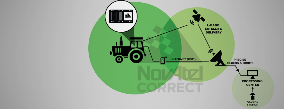
Well, NovAtel rolled out NovAtel Correct and new software at the end of March for its OEM6 high-precision receivers, which includes TerraStar’s precise point positioning (PPP) corrections. And NovAtel now has a closely associated company within the Hexagon stable, so a long-term association between NovAtel and Veripos/TerraStar is just about assured. And, with a big company group like Hexagon and many potential connections between group members with common interests, the prospect for continued investment as revenues increase means Veripos should be even better positioned going forward.
And, of course, adding NovAtel customers, including other potential OEM third parties, to the Veripos/TerraStar user base all helps both companies’ revenue and keeps their parent Hexagon happy too. So actually, it’s all about increasing the bottom line!
Today was the official start of the GEOINT 2013* Symposium. Attendance was estimated at 3,500.
Keynote speakers included James Clapper, director of National Intelligence (DNI), LTG Michael Flynn, director, Defense Intelligence Agency (DIA), and Lettitia Long, director, National Geospatial-Intelligence Agency (NGA).
The full conference guide and videos of many keynote speeches will be available through the GEOINT 2013 website in about two weeks. The full conference guide is available now as a downloadable PDF.
I had an opportunity to attend a separate press briefing by Director Long (watch below).
Included is a large exhibit hall, and today I started touring the booths. In the video below, I talk with Matt Harrison of Skyline as he demonstrates the company’s technology to generate 3D models from oblique imagery.
Also, AirBus demonstrated its global DEM data set.
Aerial photograph of the Oso mudslide, taken by the Washington State Patrol.
The March 22 mudslide in Oso, Washington, has drawn national attention to the danger of landslides. So far, the Snohomish County Medical Examiner’s office confirmed that 39 people had died and seven people remain missing.
Esri provides an interactive map for users to see where the risk of landslides is low, moderate, or high in the United States.
The map shows landslide suspectibility and incidence data from the USGS, which says this 1982 map was not intended to show landslide areas. Areas with low landslide incidence have been omitted.
Users can click any feature on the map for detailed information about the people living in that area.