Blog

  • Esri Offers Interactive Map of Landslide Risk

    Aerial photograph of the Oso mudslide, taken by the Washington State Patrol.
    Aerial photograph of the Oso mudslide, taken by the Washington State Patrol.

    The March 22 mudslide in Oso, Washington, has drawn national attention to the danger of landslides. So far, the Snohomish County Medical Examiner’s office confirmed that 39 people had died and seven people remain missing.

    Esri provides an interactive map for users to see where the risk of landslides is low, moderate, or high in the United States.

    The map shows landslide suspectibility and incidence data from the USGS, which says this 1982 map was not intended to show landslide areas. Areas with low landslide incidence have been omitted.

    Users can click any feature on the map for detailed information about the people living in that area.
     Esri-Landslide-map
  • GLONASS Loses Control Again

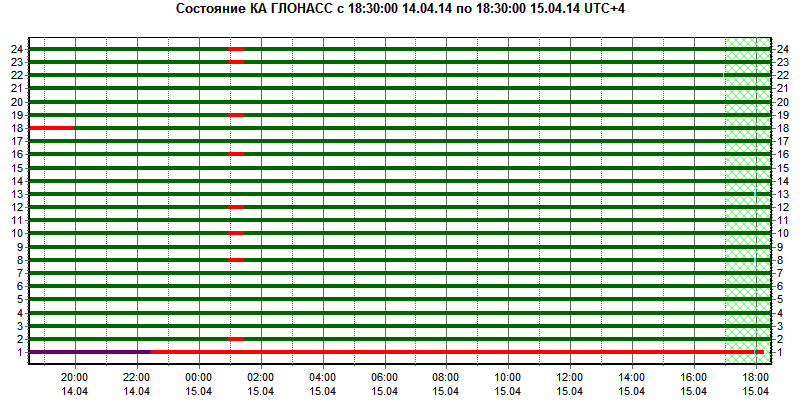
    GLONASS Loses Control Again

    The GLONASS constellation has suffered a major problem for the second time this month.

    On Monday, April 14, eight GLONASS satellites were simultaneously set unhealthy for about half an hour, meaning that most GLONASS or multi-constellation receivers would have ignored those satellites in positioning computations. In addition, one other satellite in the fleet was out of commission undergoing maintenance. This might have left too few healthy satellites to compute GLONASS-only receiver positions in some locations.

    glonass_problem

    The unhealthy status of the satellites was noted in the monitoring information provided by the Roscosmos GLONASS Information-Analytical Centre website. The problem was also reported by The Moscow Times, an English-language daily published in Russia.

  • CompassData Certified by FAA to Collect Data for Aviation Mapping

    CompassData, a worldwide provider of geospatial data and services, has received DO-200A certification by the Federal Aviation Administration (FAA) for collection and processing of survey and ground control data used in the creation of Airport Mapping Database (AMDB) products.

    “DO-200A certification enables CompassData to provide Ground Control Points (GCPs) for generation of digital aeronautical products, such as Airport Moving Maps, used by pilots in the cockpit to navigate on the ground at airports worldwide,” said Hayden Howard, CompassData Vice President. “This certification applies to custom ground control collects and to many of the GCPs that exist in our worldwide archive available off the shelf for immediate purchase.”

    In addition, CompassData has been approved to use its GCPs and Accuracy Analyst map tool to verify the accuracy of satellite or aerial imagery used in creation of AMDB DO-272C aviation products. This means CompassData may orthorectify a high-resolution DigitalGlobe satellite image, verify that the orthoimage accuracy meets sub one- and five-meter specifications, and provide the image to an aeronautical mapping firm or avionics system developer to generate commercial products.

    DO-200A standards were developed by FAA to assure the quality of data used in the preparation of aeronautical mapping, navigation and situational awareness products and systems. Prior to certification, CompassData completed a rigorous examination procedure in which FAA reviewed every step in the firm’s methodologies for collecting, processing and managing GPS-surveyed ground control to ensure the data is accurate, timely, complete, and traceable.

    FAA has granted only six LOAs (Letters of Acceptance) in the Denver ACO Region and only 24 globally. CompassData is the first in the world to receive certification for verification of data sets used to create Airport Moving Map data.

    In March, CompassData purchased the assets of Spatial Information Solutions (SIS) in Starkville, Mississippi, and announced the continued sale and support of the popular Accuracy Analyst and Topo Analyst Map Accuracy Tools. These software applications are relied upon by geospatial end users to automatically verify the accuracy of orthoimagery and digital elevation data sets, often with CompassData GCPs.

    CompassData will discuss the FAA DO-200A certification and demonstrate Accuracy Analyst and Topo Analyst Map Accuracy Tools in booth #2063 at GEOINT 13* being held April 14-17, 2014, in Tampa, Florida.

  • Trimble Offers Software Updates to Simplify Geospatial Analysis

    Trimble announced today comprehensive updates to its powerful suite of geospatial office software, including Trimble Business Center, RealWorks and Trident solutions. Together, these updates provide increased data interoperability between Trimble office software platforms, enabling users to easily combine data generated through traditional survey methods, laser scanning and mobile mapping workflows, to produce richer and more intuitive deliverables, the company said.

    “Data interoperability across Trimble software platforms provide users with seamless and efficient workflows and the flexibility to focus first on the output needed for each job,” said Alain Samaha, business area director of GIS and software for Trimble’s Geospatial Division. “Whether it is a stakeout design or a precise as-built model, users can select the best software environment to get the job done right and deliver that information in the most useable format.”

    The announcement was made at SPAR International 2014, a conference for 3D data capture, processing and delivery technologies.

    Trimble Business Center Version 3.20. Geospatial professionals now have access to an improved processing and analysis experience. With an integrated and powerful new point cloud engine, users can visualize and edit large point clouds while simultaneously working with high- resolution imagery. Combining these rich data sets into a single workflow saves time and potential conversion errors.

    Trimble RealWorks Version 8.1. The latest release of Trimble RealWorks provides surveyors and laser scanning professionals with enhanced tools that make it easier to visualize and interpret scan data. Point clouds can now be easily colorized using high-resolution and High Dynamic Range (HDR) images from professional grade external cameras, significantly reducing measurement and modeling times.

    Trimble Trident Version 6.1. Mobile mapping professionals can now combine the rich datasets captured using spherical cameras with laser scanner and inertial measurements from the Trimble MX2, to easily determine the location of surveyed features and automatically classify imaged objects.

    The new office software versions are expected to be available in April 2014 through Trimble’s worldwide Geospatial distribution network.

  • Esri Issues Help to Fight Heartbleed Bug in ArcGIS Products

    heartbleedEsri has issued guidelines for users to protect themselve against the Heartbleed Bug, officially named OpenSSL Vulnerability CVE-2014-0160 (Heartbleed).

    The Heartbleed Bug is a serious vulnerability in the popular OpenSSL cryptographic software library. This weakness allows stealing the information protected, under normal conditions, by the SSL/TLS encryption used to secure the Internet. SSL/TLS provides communication security and privacy over the Internet for applications such as web, email, instant messaging (IM) and some virtual private networks (VPNs).

    Some 17 percent (around half a million) of the Internet’s secure web servers certified by trusted authorities were believed to be vulnerable to the attack, allowing theft of the servers’ private keys and users’ session cookies and passwords.

    Since learning about the vulnerability, Esri staff have been performing maintenance to validate, secure, and patch Esri servers and infrastructure to close this vulnerability and ensure Esri customers are protected.

    Esri suggests its customers read its Knowledge Base Technical Article to determine the action required for their particular ArcGIS products and services. As an extra precaution, users may want to change their passwords.

  • NGA’s Bryan Goltry Honored with Lt. Michael P. Murphy Award

    This morning at the United States Geospatial Intelligence Foundation’s (USGIF) GEOINT 2013* Symposium, the 2013 Lt. Michael P. Murphy Award in Geospatial Intelligence was presented to Bryan Goltry, an analyst at the National Geospatial-Intelligence Agency (NGA). NGA Director Letitia A. Long and Dr. Todd S. Bacastow, professor of practice for geospatial intelligence at Penn State University, presented the award to Goltry on the main stage directly following Long’s keynote address.

    “The Murphy award committee felt that Bryan’s independent studies made an exceptional contribution to understanding the principle dimensions of the geospatial intelligence profession,” said Bacastow.

    Goltry is a geospatial analyst with NGA’s Analysis Directorate, and recently completed Penn State’s master’s degree program in homeland security with a GEOINT focus. Goltry began his GEOINT career with Earth Satellite Corp., where he assisted with NGA’s GeoCover project. He then served as an imagery analyst at NGA from 2002 to 2006. In 2006, he worked in the private sector with 3001 Inc. as a program manager providing imagery and geospatial analysis services to customers in the Intelligence and Defense Communities. Goltry received his bachelor’s degree in geographic sciences with concentrations in GIS, global studies, and environmental studies from James Madison University.

    “Goltry’s contributions to NGA and his tradecraft continue the high standards established by the Murphy Award,” said Mark Brender, executive director of the DigitalGlobe Foundation. “We congratulate him for his excellent work and passion for his industry.”

    The Murphy Award is named for Navy SEAL Lt. Michael P. Murphy, a distinguished Penn State alumnus. Murphy was killed June 28, 2005, by enemy forces during a reconnaissance mission in Afghanistan. For his selfless leadership and courageous actions, he was posthumously awarded the Medal of Honor. The award, in his honor, recognizes achievement by a Penn State graduate student who is serving or has served in the U.S. Armed Forces or U.S. Intelligence Community. Recipients are
    chosen based upon demonstration of exceptional contributions to the discipline after completing Penn State’s Graduate Certificate in Geospatial Intelligence, as part of the university’s Master of Geographic Information Systems program.
    The generosity of USGIF, the DigitalGlobe Foundation, and faculty, staff, and friends of Penn State fund the Murphy Award.

  • USGIF Chairman Stu Shea Steps Down After 10 Years of Service

    After founding the United States Geospatial Intelligence Foundation (USGIF) in 2004, serving as its first president and chief executive officer, and presiding as the Chairman of the Board for 10 years, Stu Shea this morning announced during the GEOINT 2013* Symposium he is stepping down from his position as chairman of the foundation. The Honorable Jeffrey K. Harris was elected Shea’s successor by the board of directors at its last meeting. Harris will assume chairman duties effective immediately.

    “USGIF has grown over the past decade to become exactly what myself and the other founders envisioned for the GEOINT Community,” Shea said. “From a small gathering of intelligence professionals, USGIF has built a community around and furthered GEOINT tradecraft, fueled by the strategic direction of the Board, the talented USGIF staff, and countless Foundation members, partners, and volunteers. Our accomplishments have been a team effort, and I am so very proud to have been a part of this success.”

    Since USGIF was incorporated as a 501(c)(3) educational, nonprofit foundation in January 2004, Shea has dedicated much of his time and energy as chairman. He served USGIF in a part-time capacity, one that sometimes equaled a second full-time job.

    Under Shea’s leadership, the foundation has grown from seven founding companies to nearly 250 member organizations, awarded nearly $700,000 in scholarships, accredited eight collegiate geospatial certificate programs, and expanded the GEOINT Symposium from a fledgling event into the largest annual gathering of intelligence professionals, numbering more than 4,000 attendees annually.

    “Stu is a valuable asset to the entire Intelligence Community, but particularly the GEOINT Community,” said USGIF Chief Operating Officer Aimee McGranahan. “I’ve been a part of USGIF since the beginning, and it has been an honor every day to be a part of the Foundation’s success under his leadership. Stu’s ability to make decisions and set direction, as well as his enthusiasm and passion for national security, has driven the organization to accomplish many successes. It was these same characteristics the board carefully sought when making the decision to elect Jeff as Stu’s successor.”

    Former director of the National Reconnaissance Office (NRO) and undersecretary of the U.S. Air Force, Jeffrey K. Harris has contributed to U.S. national security in both government and industry for 35 years. He has fostered new technologies, programs, and capabilities that have contributed significantly toward keeping our nation secure.

    Harris is retired from Lockheed Martin, where he was a corporate officer and served as president of Lockheed Martin Missiles and Space, as well as president of Lockheed Martin Special Programs. Prior, he served as president of Space Imaging, the first company to provide commercial high-resolution satellite imagery.

    Before entering the private sector, Harris served in federal leadership positions, including Assistant Secretary of the Air Force for Space, director of the NRO, and associate executive director of the Intelligence Community Management Staff. In all of these capacities, he provided direct support to both the Secretary of Defense and the Director of Central Intelligence.
    Harris has received numerous awards, most notably the National Intelligence Distinguished Service Medal, the CIA Distinguished Service Medal, the NRO Medal for Distinguished Service, Aviation Week’s Laureate Citation, and the James V. Hartinger Award for military space achievement. He was also the 2006 recipient of USGIF’s Lifetime Achievement Award.

    USGIF is a nonprofit educational foundation dedicated to promoting the geospatial intelligence tradecraft and developing a stronger GEOINT Community with government, industry, academia, professional organizations, and individuals who apply geospatial intelligence to address national security challenges. USGIF’s mission is to build the community, advance the tradecraft, and accelerate innovation. The GEOINT Symposium is hosted annually by USGIF.

  • Pitney Bowes, INRIX Join on Location Intelligence for Traffic

    Pitney Bowes Inc. has entered into a multi-year partnership with INRIX, Inc., provider of traffic information and driver services, to deliver advanced location intelligence solutions through the company’s traffic intelligence platform.

    By integrating location capabilities with traffic analysis, INRIX and Pitney Bowes will enhance the driving experience of today’s connected drivers, the companies said. By delivering this information through INRIX’s mobile app, users are empowered to make better location-based decisions in real-time.

    “Pitney Bowes’ location intelligence solutions can add compelling new capabilities to the existing products of mobile-oriented companies such as INRIX,” said James Buckley, Senior Vice President and General Manager, Location Intelligence, Pitney Bowes. “Our products help unearth non-obvious relationships between specific locations to improve the customer experience and drive loyalty.”

    INRIX has designed a leading traffic intelligence platform that uses smart data and advanced analytics to solve transportation issues worldwide. The company uses a unique approach called “smart crowd-sourcing” that analyzes real-time traffic speed and incident data from a wide variety of public and private traffic sources ranging from road sensors and up-to-the-minute traffic speeds and community reports crowd-sourced from millions of vehicles and mobile devices throughout the day. Whether through an in-car or smartphone navigation application, a local newscast or the company’s INRIX Traffic app, INRIX offers up-to-the-minute traffic information and other driver services to help more than 150 million drivers save time, fuel and money.

    Pitney Bowes Location Intelligence solutions merge organizational data with location data to provide users with the capability to make more informed decisions. For INRIX, this technology compiles and correlates addresses with coordinates from a mobile device to establish real-time location or a desired destination. Combining that with other data such as specific traffic flow, demographics and behavior patterns, users can uncover key points of interest by accessing Pitney Bowes advanced location search. For example, if a consumer is planning to visit a popular department store in a specific region, the technology makes it possible to suggest a relevant restaurant recommendation for lunch, based on the data that is collected about user preferences, convenience, proximity and projected traffic patterns.

    “INRIX had a number of compelling reasons to partner with Pitney Bowes,” said Scott Sedlik, Vice President, Product Planning and Market Development for INRIX. “Our customers are looking to make real-time decisions using location data, and Pitney Bowes has the most comprehensive suite of offerings to fulfill that need. Other key reasons for teaming include a strong customer focus and alignment with our own strategic goals and approach.”

  • Tax Day Mapped: How Do States Tax Residents?

    Esri has provided an interactive state taxes story map. Using the map, you can view tax rates by state for income tax, sales tax, and property tax to see how each state raises money from its residents. You can also explore demographic information in the popups to see whether the state’s population and relative wealth affects how it chooses to tax its citizens. See below:

  • Trimble Delivers 3D Scanning Extension for SketchU

    Trimble Business Center Version 3.20

    Trimble has released the Trimble Scan Explorer Extension for SketchUp Pro, what it calls a powerful, easy-to-use tool enabling architects, engineers and geospatial professionals to create models from 3D scanning data.

    The new software connects the high-resolution field data from Trimble scanners with intuitive and powerful professional modeling software, to simplify the process of creating, accessing and sharing precise 3D models of the real-world environment.

    The Trimble Scan Explorer Extension dramatically reduces the time required to generate a SketchUp Pro 3D model from scan data, the company said. Streamlined tools and one-touch features allow users to quickly extract construction points and lines that are used as a guide to simplify and expedite the modeling process. Automated plane extraction tools further increase modeling efficiency, particularly when modeling building interiors and facades.

    For improved visual references when working with point clouds, the extension includes a simple-to-use edge extraction tool, allowing users to easily decipher important cues from the scan data directly into their model building space. Structural edges are brought into SketchUp as guidelines, and one button push displays the shell of the structure.

    “By seamlessly integrating powerful tools across our broad range of best-in-class solutions, Trimble is helping transform the way our customers work and accomplish more every day. The integrated workflow provided by Scan Explorer brings the accessibility of 3D modeling to more users for as-built analysis and design changes,” said Alain Samaha, business area director of GIS and Software for Trimble’s Geospatial Division. “Professionals can now easily create visual 3D models that provide a true representation of the environment they are working in—improving the communication, collaboration and quality of deliverable that they can provide to their clients.”

    “SketchUp’s enormous popularity as a design tool is rooted in its capacity to make many complex processes easier and more efficient,” said Chris Keating, director of the Architecture Division within Trimble Buildings Group. ”The Trimble Scan Explorer Extension for SketchUp Pro reinforces our mission to deliver SketchUp’s benefits to new users and for new uses.”

    The release was announced at SPAR International 2014, a conference for 3D data capture, processing and delivery technologies.

    Trimble Scan Explorer Extension for SketchUp Pro is available through Trimble’s Geospatial distribution network and online.

    Trimble RealWorks Version 8.1 Bridge Clearance

    Trimble Trident Version 6.1

  • Report from GEOINT: The Search for Malaysia Flight 370

    Day One Coverage

    Today I attended the “GEOINT Forward” which is a pre-conference day consisting of over a dozen loosely related sessions. If there was a common theme it would have to be the increasing evolution of the GEOINT community toward Human Geography, Social Media, Big Data, Small Satellites and Chaos Management.

    A most interesting keynote speaker was Dave Snowden (no relation to NSA whistleblower Edward Snowden) founder and chief scientific officer of Cognitive Edge working to analyze complex issues relating to strategy and organizational  decision making.  He pioneered a science based analysis of organizations drawing on anthropology, neuroscience and complex adaptive systems theory.  The key analysis tool they created  is SensesMaker, a survey tool that extracts and organizes how respondents make sense of the world through micro-narratives in social settings.  Using a patented method the respondent interprets their own story into a series of abstract constructs that feel more like a game than a survey, but allows profound meaning to emerge. This interpretation adds layers of meaning rather than simply interpreting the story and provides quantitative data which can always be linked back to the original material.

    There were several sessions related to Chaos Management of disasters both natural and man-made. Dr. Shay Har-Noy of Digital Globe demonstrated TomNod (www.tomnod.com/nod/) which is a crowd sourcing effort of Digital Globe in which the public has access to thousands of images so that millions of eyes could help scour the imagery looking for signs of the missing aircraft. Once potential sites were indentified, experts could then focus their attention on the sites.  Here is a short video clip of some examples.  (Excuse the quality of the video, the room was dark, sound system poor and the built-in microphone less than ideal)

  • Protect, Toughen, Augment: Words to the Wise from GPS Founder

    Protect, Toughen, Augment: Words to the Wise from GPS Founder

    “What can we do to reduce the vulnerability [of GPS] and ensure that the expectations of the public are going to be met?” asked Dr. Bradford Parkinson as he opened his presentation this morning (Tuesday, April 15) at the European Navigation Conference, ENC-GNSS 2014 in Rotterdam, The Netherlands.

    Parkinson went through his 61-slide, 50-minute briefing on what he called “PTA” — Protect, Toughen, and Augment — a proposal concerning not only GPS but PNT systems globally. An article by Parkinson based on this talk will highlight the special 25th Anniversary edition of GPS World, to appear in conjunction with this year’s July issue.

    Brad Parkinson
    Brad Parkinson

    After briefly overviewing the many worldwide applications of GPS and its penetration and participation in several vital markets, Parkinson stated “If we want to ensure the economic benefits of GPS, there are some essential needs that a user has. The first need is availability, and I’m defining availability in a certain way. It’s at the required accuracy for the application involved, and it has a bound on the random events that happen out there.

    “The second required aspect is integrity, as in ‘I know I’m getting this accuracy, the system is not lying to me.’  In many cases, it’s required that the system not lie to you more often than once in 10 to the seventh (10 million) times.”

    Parkinson developed his Protect, Toughen, and Augment proposal in part in response to a remark he heard from a high U.S. government official who opined that “GPS is much too vulnerable, we need to replace it.” While agreeing that the system is vulnerable, Parkinson has strived for a more constructive approach to the problem.

    At the end of his presentation, Parkinson introduced one of his colleagues in the audience, from his early days on the GPS Program, and stated that if it was not for Hugo Fruehauf’s expertise with atomic reference systems in 1973, there might never have been a GPS program.

    Parkinson was among attendees at an ENC event at City Hall hosted by the Mayor of Rotterdam, The Netherlands. From left are Hugo Fruehauf, Mrs. Bradford "Ginny" Parkinson, Professor Bradford Parkinson, Don Jewell — GPS World Defense Editor, Jac Spaans — Chairman of the Organizing Commitee of the ENC, and Adrianna Spaans.
    Parkinson was among attendees at an ENC event at City Hall hosted by the Mayor of Rotterdam, The Netherlands. From left are Hugo Fruehauf, Mrs. Bradford “Ginny” Parkinson, Professor Bradford Parkinson, Don Jewell — GPS World Defense Editor, Jac Spaans — Chairman of the Organizing Commitee of the ENC, and Adrianna Spaans.