Topcon Positioning Group has released the MAGNET Field GIS software kit designed for efficient data collection, navigation and maintenance tasks.
“MAGNET Field GIS is field data collection software with extremely useful data sharing capabilities,” said Jason Hooten, national sales manager, GIS products. “Utilizing the cloud, MAGNET Field GIS can send and receive data via a company’s MAGNET Enterprise account, allowing professionals in the field greater productivity and less time wasted driving to and from an office to deliver collected data.
“MAGNET Field GIS is powerful and intuitive — built to easily recognize and adapt to a user’s surroundings,” said Hooten. “Whether in an urban area within a GNSS network or in a rural setting with a DGPS connection, MAGNET Field GIS provides a modern data collection solution.”
The software package also includes features such as Microsoft Bing Maps for real-time background imaging, popular GIS file-format compatibility and a customizable interface.
The satellite ASTRA 5B, which will become part of the European Commission’s European Geostationary Navigation Overlay Service (EGNOS), launched successfully after a one-day delay. It lifted off on March 22 aboard an Ariane 5 ECA rocket at 2204 GMT (6:04 p.m. EDT) from the Guiana Space Center near Kourou, French Guiana.
Officials from Arianespace, the French launch services company, declared the mission a success following the rocket’s deployment of the ASTRA 5B and Amazonas 4A communications satellites about a half-hour after liftoff, reports Spaceflight Now.
ASTRA 5B carries a hosted L-band payload for EGNOS. It will also extend transponder capacity and geographical reach over Eastern Europe and neighboring markets for DTH, direct-to-cable, and contribution feeds to digital terrestrial television networks.
“Today’s successful launch, the 59th in a row for Ariane 5, confirms the unrivaled reliability and availability of the European launcher,” said Stephane Israel, chairman and CEO of Arianespace. “We take particular pride in being able to offer this service excellence to two leading European operators, SES and Hispasat, both long-standing customers of Arianespace, as well as the European Commission, which has an EGNOS satellite navigation payload integrated on the ASTRA 5B satellite.”
The spacecraft, based on the Airbus Defence and Space Eurostar E3000 satellite bus, is flying with a hosted L-band navigation payload for EGNOS, which augments GPS navigation signals over Europe for specialty users such as the aviation and surveying industries.
“EGNOS will be able to continue to provide valuable positioning services to users all over Europe, be it in the field of aviation, transport or agriculture,” said Christoph Kautz, deputy head of the European Commission’s enterprise and industry unit.
ASTRA 5B was built by Airbus Defence and Space (formerly Astrium) in Toulouse, France, using a Eurostar E3000 platform. The multi-mission satellite will be located at 31.5 degrees East.
PeopleNet, a Trimble company and provider of fleet mobility technology that optimizes performance and decision-making management, has launched a mapping and navigation solution for its Energy Services suite, serving U.S. fleets in the upstream and midstream sectors.
“Our Energy Services suite capitalizes on our proven fleet mobility solutions that increase efficiency, safety and compliance for all oilfield service segments, including producers, oilfield construction and well service companies, as well as haulers of fluid and crude oil. In addition, we’re leveraging our parent and sister companies’ industry-standard lone-worker, mapping and navigation technologies to fast-track development of new services to continue improving operations for Energy Services fleets,” said David Buhl, leader of PeopleNet’s dedicated Energy Services Division.
PeopleNet’s new Energy Services mapping and navigation solutions are based on exclusive, detailed maps of private and leased oilfield roads that facilitate vehicle navigation to and from well sites, coordination of disparate workforces to promote efficiency, location monitoring of equipment to ensure vehicles are on the correct route for least-cost routing. The Oil and Gas Map Portal is a web-based application used by back-office dispatch personnel to manage the navigation needs of vehicles and includes reporting, dashboards, and scorecards that help manage compliance with producer-landowner road-usage agreements.
CoPilot Oil and Gas Navigation is an in-cab application that uses oil and gas field mapping for providing turn-by-turn directions to the driver to enable on-time arrivals and scheduling. Location data, including wells, is installed onto the in-cab device and is accessible in the points of interest menu. When a location is selected, the application provides turn-by-turn directions to the driver.
A growing number of energy services fleets are using PeopleNet technology to promote on-time schedules, enhance service levels and improve safety/compliance, including Gibson, Missouri Basin Well Service, Nuverra Environmental Solutions, Rockwater, and Tankstar USA.
These new services are based on reliable two-way messaging and GPS, supported by tri-mode communications (cellular, satellite and Wi-Fi). They are being added to PeopleNet’s current Energy Services offerings, which include: Crude Workflow for improving driver efficiency; eDriverLogs HOS application with oil field regulations; Speed Gauge speed monitoring; and Automated Fuel Tax reporting for eliminating manual trip sheets.
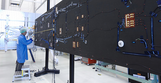
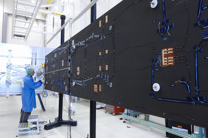
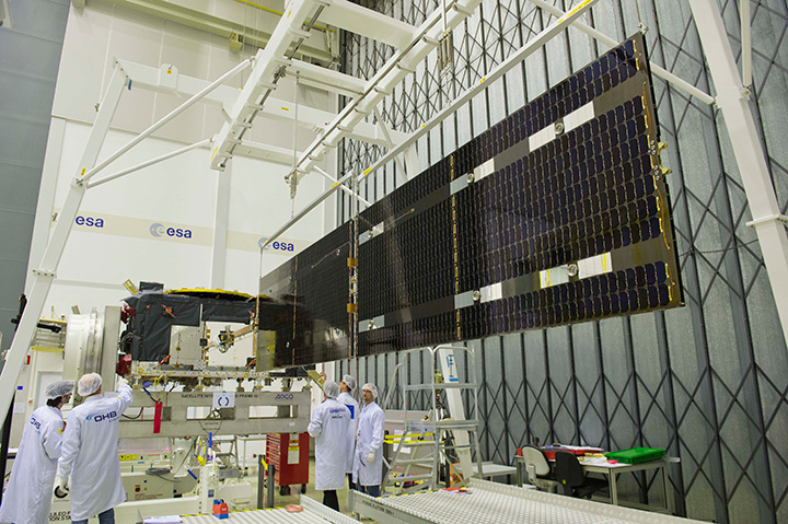
Solar arrays for a Galileo Full Operational Capability (FOC) satellite at the Dutch Space company near Leiden in the Netherlands. A pair of 5 m-long solar arrays supply 1.9 kilowatts of power – about the same as an average household’s consumption. The side of the solar array normally left in shadow is seen here.
By the European Space Agency
As they bathe the ground below them in test navigation messages, Europe’s Galileo satellites are kept alive by the Sun.
A pair of 5 m-long solar arrays supply 1.9 kilowatts of power – about the same as an average household’s consumption. These arrays are sourced from the Dutch Space company in the Netherlands.
Located just outside Leiden, a short drive from ESA’s Technical Centre, the Airbus Defence and Space subsidiary is based in what might appear to be a standard office building, the only clue to its space-based focus being an Ariane 5 frame outside.
Inside its specialized facilities include a class 100 000 cleanroom, space simulation equipment and a “Very Large Sun Simulator” — a giant camera flash able to test the electrical performance of the solar arrays the company supplies to about two thirds of ESA missions — which includes all Galileo satellites commissioned to date, as well as one of their two GIOVE predecessors.
“Think of us as the prime contractor for Galileo’s solar panels,” explains senior project manager Jan Zuidam, overseeing the work for Dutch Space. “We build nothing directly ourselves, but — working with a network of partner companies — oversee the panels’ design, engineering management, assembly and testing, all performed here in these buildings.
The composite panel substrates, sourced from local Dutch company Airborne Composite, are equipped with solar cells in the Airbus Defence and Space facility in Ottobrunn, Germany, with the photovoltaic cells themselves sourced from German company Azur Space Solar Power. It is a bit like the way silicon chips are mounted on printed circuit boards, only on a much bigger scale.”
The cells in question are state-of-the-art “triple junction” gallium arsenide designs, with sandwiched layers optimised for different segments of the solar spectrum.
At Ottobrunn these cells are interconnected together into “strings” that run the length of each panel. The bare cells have also have protective cover glass added at this stage, without which they would be quickly tarnished by the radiation and unfiltered sunlight prevailing in orbit.
Testing
Before delivery to Dutch Space, each panel is thermal vacuum tested at IABG, Germany, followed by the absolute performance measurement and inspection.
Solar arrays for a Galileo Full Operational Capability (FOC) satellite at the Dutch Space company near Leiden in the Netherlands. A pair of 5 m-long solar arrays supply 1.9 kilowatts of power – about the same as an average household’s consumption. The side of the solar array normally left in shadow is seen here.
This includes flash testing to illuminate all the cells at once to check the arrays meet the set power requirements, as well as electrical luminescence testing, where an electrical current is run through each string to make them glow red, basically reversing the way solar cells usually work. Visual inspection is typically enough to ensure all connections are properly linked.
At Dutch Space, the panels from Ottobrunn are integrated together with the mechanisms, typically sourced from local Dutch companies assembled and tested by Dutch Space, into complete solar array wings.
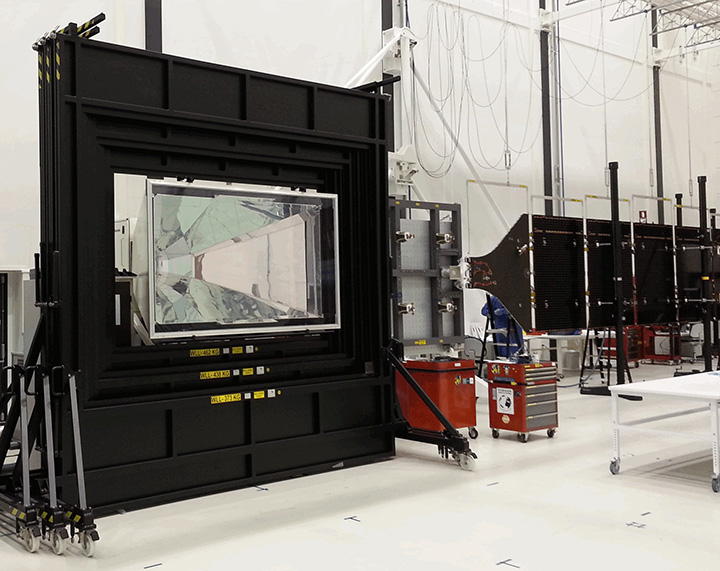
The completed wings are suspended on specially weighted deployment rigs, to compensate for the presence of gravity the 29 kg wings are not designed to endure. Here alignment testing is performed, to check the wings will unfold in a straight line as planned.
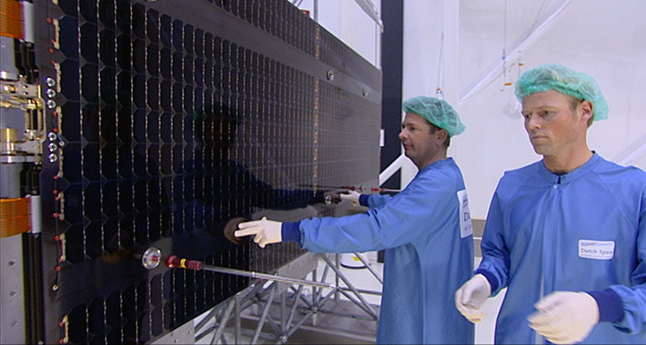
Galileo solar arrays being inspected in the Dutch Space cleanroom. The panels received from Ottobrunn in Germany are integrated together with the mechanisms, typically sourced from local Dutch companies assembled and tested by Dutch Space, into complete solar array wings. The completed wings are then suspended on specially weighted deployment rigs, to compensate for the presence of gravity the 29 kg wings are not designed to endure. Here alignment testing is performed, to check the wings will unfold in a straight line as planned.
“Alignment testing involves the use of reference mirrors and theodolites to check the arrays’ straightness, down to a scale of a tenth of a millimeter at wing tip,” Jan explains.
“In orbit, any bad alignment would be felt by the satellite’s attitude control system, and might even reduce a satellite’s operational life. We also make stiffness tests, which involves hanging weights on a rope on the end of the array, to see what the resulting displacement is. Flex to 100 mm is expected, but not more.”
A large‘ambient pressure temperature test chamber can simulate the rapid temperature swings the arrays will experience as they pass between orbital daylight and darkness. A much smaller cabinet does the same in vacuum conditions, and is used for accelerated lifetime testing to simulate the total life of the arrays, although only for a 50 x 50 cm sample array.
Dutch Space has been designing its Advanced Rigid Array family of arrays for space missions since the 1970s, Jan recalls: “Each mission has different requirements. Low-Earth orbiting arrays such as those for ESA’s Automated Transfer Vehicle need protection from erosive atomic oxygen, found at the top of the atmosphere, while deep space missions like Rosetta or the US Dawn spacecraft require low-intensity low-temperature LILT solar cells to go on producing power far from the Sun.
Deployment of the solar wings on the first Galileo satellite ‘Full Operational Capability’ satellite is shown being checked at ESA’s ESTEC technical hub in the Netherlands at the end of June 2013. The navigation satellite’s pair of 1 x 5 m solar wings, carrying more than 2500 state-of-the-art gallium arsenide solar cells, will power the satellite during its 12-year working life.
“Galileo flies in medium-Earth orbit, and in the process passes through Earth’s radiation belts. This heightened radiation exposure implies a higher loss factor of cells, which is accounted for with higher capacity at the start. We design solar arrays based on their end-of-life performance — how can we ensure they will still meet mission requirements after 12 years in orbit?”
Galileo’s solar arrays are also designed to guard against potential harmful electrostatic discharge — a spark caused by the build-up of static — by introducing gaps any charge cannot traverse, as well as other voltage safeguards.
“As a safety margin, Galileo’s arrays can go on operating satisfactorily with the loss of one complete string of cells.”
The completed arrays are sent on to Full Operational Capability (FOC) prime contractor OHB in Bremen, Germany for integration onto the satellites. Although this is not quite the end of the story for Dutch Space.
“We have a 100% record of successfully deployed wings in space and we’d like to keep it that way,” Jan comments. “So we provide training to our customers on handling and storing the wings, and especially in working with our unique hold-down system that keeps the solar arrays stacked on either side of the satellite during launch.”
The panels are delicate, composed of just four layers of carbon fibre, and would break easily if struck hard. They are therefore tied tight against the satellite during the violence of launch.
The Kevlar restraint cables are then severed by thermal knives, with two in place per each hold-down point.
“The Kevlar is weakened gradually instead of suddenly snapping,” Jan explains. “This reduces the amount of shock the arrays experience, compared to the pyros or unwinding rods that other companies use. The arrays then unfold gradually due to springs in the hinges, the process taking a few minutes in all.
“But the system depends on correct tensioning at the outset, which is why we like to be there in person for this point.”
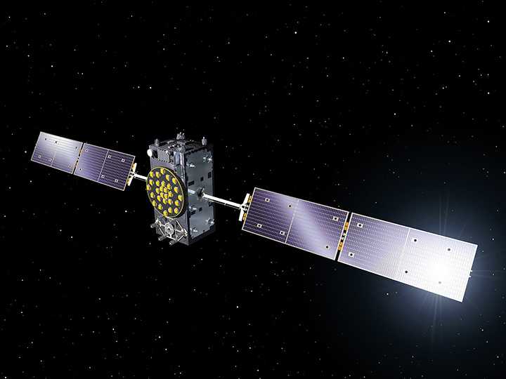
A Galileo Full Operational Capability (FOC) satellite, following on from the first four Galileo satellites already in orbit. A total of 22 FOC satellites are on the way, built by OHB in Germany with navigation payloads from Surrey Satellite Technology Ltd. in the UK.
Dutch Space is well ahead on its Galileo obligations, with 88 substrate panels manufactured and 72 panels equipped with solar cells ready for wing integration. They are carefully stored in gaseous nitrogen until needed, separately from each other for the most part, with integration performed before delivery.“Our continued involvement with Galileo has been very important to the company,” reflects Jan.
“Dutch Space has worked on batch production previously, such as with solar arrays for the ATV and the US Orbital company’s Cygnus supply vehicle to the International Space Station, but the scale of Galileo is even larger.
We have had a valuable learning curve, finding ways to optimize our production flow and working methods so that we’ve been able to reduce the time needed by 50% from the initial satellite to the latest. And all the things we learn should make us leaner and cheaper for future one-off missions as well.”
Russia has launched another GLONASS-M satellite into space, reports Spaceflight Now. The launch occurred on Sunday. The Soyuz 2-1b rocket lifted off at 22:54 GMT (6:54 p.m. EDT) from the Plesetsk Cosmodrome about 500 miles north of Moscow.
The GLONASS-M satellite, designated No. 54, was manufactured by ISS Reshetnev and is designed for a seven-year operational life. A spokesperson with the Russian Aerospace Defense Forces told Interfax the spacecraft was communicating with ground controllers and functioning normally.
Five GLONASS satellites are scheduled for launch this year.
The report of Working Group A on Compatibility and Interoperability, held November 11-13, 2013, in Dubai, United Arab Emirates, is now available as a downloadable PDF. It is also available on the ICG Information Portal.
A judge for the National Transportation Safety Board (NTSB) dismissed the Federal Aviation Administration’s (FAA’s) attempt to punish Ralph Pirker for laundry list of infractions claimed by the FAA when he flew a Ritewing Zephyr drone around the University of Virginia Charlottesville campus to generate promotional aerial photography and video of parts of the campus. You can read the list of infractions in an article I wrote in November 2013.
NTSB Administrative Law Judge Patrick Geraghty ruled that “there was no enforceable FAA rule or FAR Regulation applicable to model aircraft or for classifying model aircraft as an UAS.”
Futhermore, Judge Geraghty ruled the following:
Neither Part 1, Section 1.1, or the 49 U.S.C. Section 40102(a)(6) definitions of “aircraft” are applicable to, or include a model aircraft within their respective definition
Model aircraft operation by the Respondent was subject only to the FAA’s requested voluntary compliance with the Safety Guidelines stated in AC 91-57”.
As Policy Notices 05-01 and 08-01 were issued and intended for internal guidance for FAA personnel, they are not a jurisdictional basis for asserting Part 91 FAR enforcement authority on model aircraft operations.
Policy Notice 07-01 does not establish a jurisdictional basis for asserting Part 91, Section 91.13(a) enforcement on Respondent’s model aircraft operation, as the Notice is either (a) as it states, a Policy Notice/Statement and hence non-binding, or (b) an invalid attempt of legislative rulemaking, which fails for non-compliance with the requirement of 5 U.S.C. Section 553, Rulemaking.
Specifically, that at the time of Respondent’s model aircraft operation, as alleged herein, there was no enforceable FAA rule or FAR Regulation applicable to model aircraft or classifying model aircraft as an UAS.
Where does the FAA go from here?
First of all, the order specifically states that the “NTSB Administrative Law Judge’s dispositional order is not a final Board decision in this matter. This order is appealable to the full five-member Board and is not of precedential value (see 49 C.F.R. § 821.43).”
As expected, within a day of the ruling, the FAA filed an appeal:
“The FAA is appealing the decision of the NTSB Administrative Law Judge to the full National Transportation Safety Board, which has the effect of staying the decision until the Board rules. The agency is concerned that this decision could impact the safe operation of the national airspace system and the safety of people and property on the ground.”
Notice the language above states that the decision is on hold until the full board rules. The problem for the FAA is that wannabe commercial UAS operators were already chomping at the bit like a pack of race horses waiting for the starting gate to open. Now that the gate has been cracked open a bit, horses are busting through it at full speed. If the FAA had an enforcement problem before, it’s just been compounded tenfold.
Stayed tuned as this tremendous geospatial technology drama continues to unfold before our eyes…
The Search for Flight MH370
If you’re one of the few people in the world who haven’t heard about missing Malaysian Flight MH370, it disappeared on March 8 with 239 souls on board, thirty minutes into a flight from Kuala Lumpur to Beijing, and has not been found. It’s resulted in a massive international search.
Because the search area is so massive, satellite imagery is being used to assist in the search effort. Satellite operator DigitalGlobe, Inc., launched a crowdsourcing campaign that will allow anyone to help look for the missing Malaysia Airlines flight MH370 by combing through satellite images for clues of its whereabouts.
Anyone can begin searching the satellite images for the Boeing 777 aircraft, tagging anything that looks suspicious. Each pixel on a computer screen represents half a meter on the ocean’s surface.
The Longmont, Colorado, company said two of its commercial satellites have already collected images comprising roughly 1,988 square miles at the confluence of the Gulf of Thailand and the South China Sea, where the Beijing-bound aircraft mysteriously went missing on Saturday. The company is continuing to update the images to reflect new information about the search area provided by the Malaysian government. Click here to visit the website and learn more about joining the effort to find MH370.
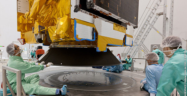
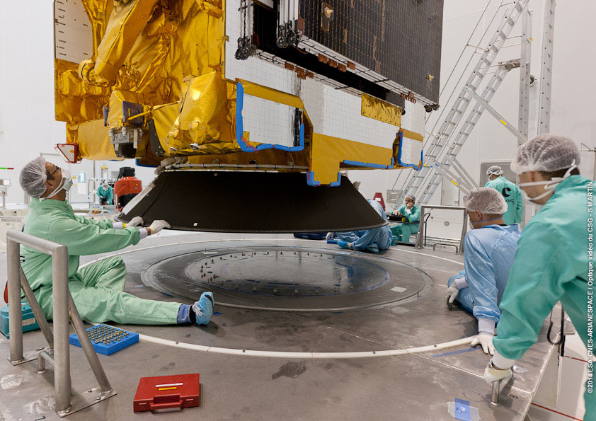
The ASTRA 5B is installed in preparation for launch Friday, March 21. (Photo credit: Arianespace)
The launch of the satellite ASTRA 5B, which will become part of the European Commission’s European Geostationary Navigation Overlay Service (EGNOS), is scheduled for Friday, March 21, according to satellite company SES. It will be launched into space from the European Space Centre in French Guiana on board an Ariane 5 ECA rocket between 19:05 p.m. and 20:02 p.m. local time (23.05 – 00.02 CET; 18.05 – 19.02 EDT).
ASTRA 5B will carry a hosted L-band payload for EGNOS. It will also extend transponder capacity and geographical reach over Eastern Europe and neighboring markets for DTH, direct-to-cable, and contribution feeds to digital terrestrial television networks.
ASTRA 5B was built by Airbus Defence and Space (formerly Astrium) in Toulouse, France, using a Eurostar E3000 platform. The multi-mission satellite will be located at 31.5 degrees East.
“The launch of ASTRA 5B will be the 39th launch of an SES satellite on board a European Arianespace launch vehicle,” said Martin Halliwell, chief technology officer of SES. “Our long-standing relationship is based on this proven track record and shows the continuous confidence we have in Arianespace and our commitment to Ariane as a launch vehicle. We look forward to a successful mission with this longstanding launch partner.”
Google has been collaborating with universities, research labs, and industrial partners in nine countries, to concentrate the past 10 years of research in robotics and computer vision into a mobile phone.
Google’s Advanced Technology and Projects group (ATAP) heads the project, which aims to make it possible to create a 3D model of the space around a smartphone. For instance, a user can map an area, such as a home, by walking around with the phone.
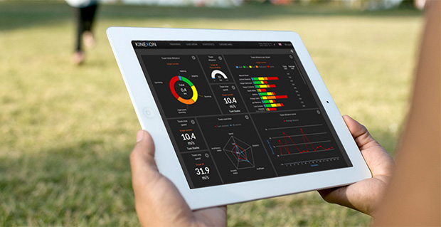
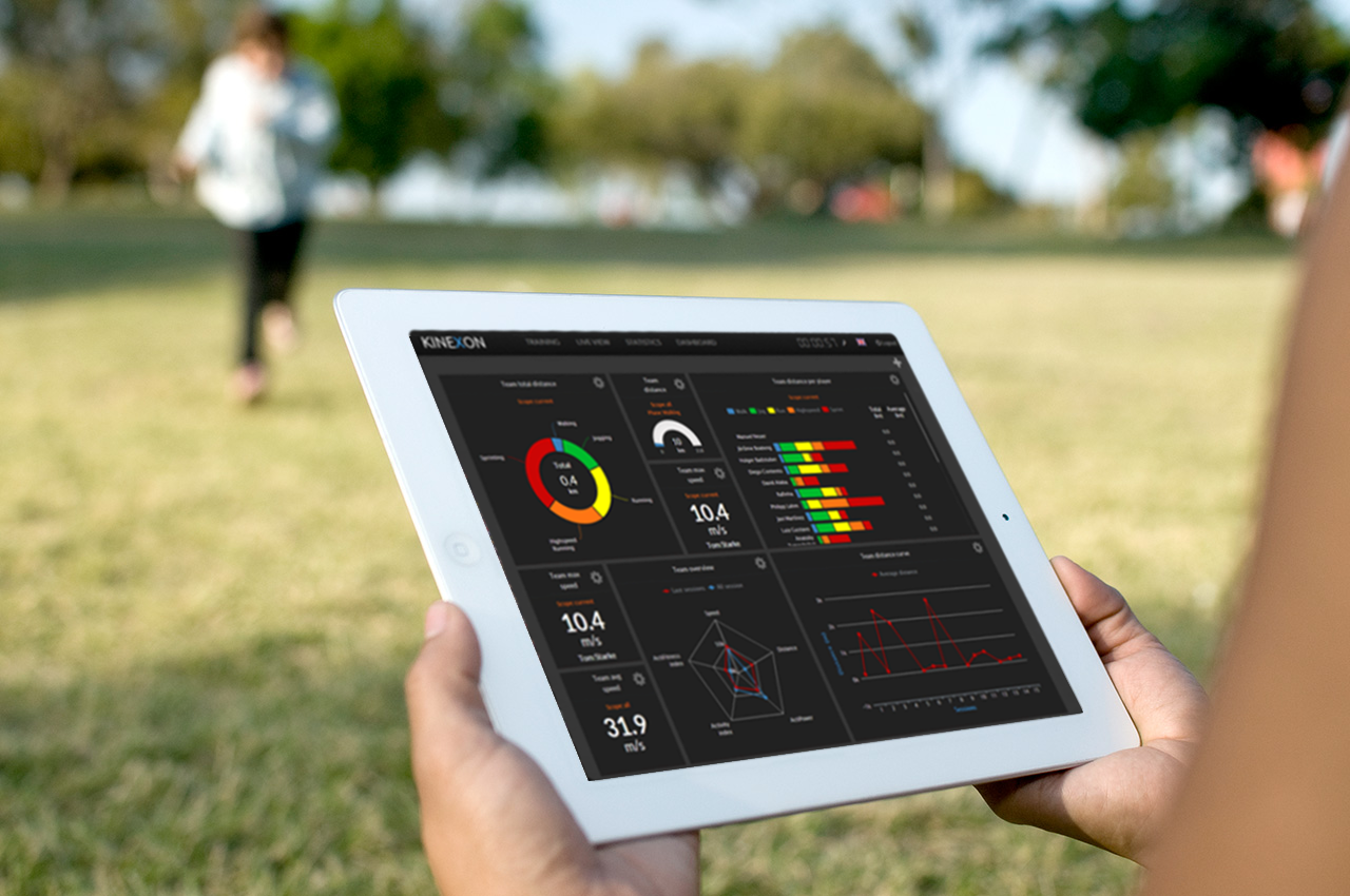
2013 Galileo Master KINEXON offered a precise tracking and monitoring solution for sports and healthcare.
The European Satellite Navigation Competition (ESNC) is looking for services, products, and business innovations that use satellite navigation in everyday life. Prizes will be awarded by some of the most relevant institutional GNSS stakeholders, such as the European GNSS Agency (GSA) and the European Space Agency (ESA). In addition, partner regions from all over the world are hosting regional challenges.
The competition officially kicks off at the European Navigation Conference in Rotterdam on April 15, but submissions are being accepted from April 1 to June 30.
The prize pool of ESNC 2014 is expected to value about 1 million euros. Awards include cash prizes, business incubation, business coaching, patent consulting, technical support, access to testing facilities, prototype development, publicity, marketing support, feasibility studies, access to experts and public funding, and more.
In 2013, 25 partner regions offered prizes, and seven special prizes were provided by leading European industry and research partners. Entries will be assessed by the expert panels of the regions and special prize partners.
The overall winner — the Galileo Master — will be selected from among all regional and special prize winners by an international panel of high-ranking experts. The Galileo Master will be revealed at an awards ceremony in Munich, Germany, in October, and will receive an additional cash prize of 20,000 euros as well as the chance to realize the winning idea as part of a six-month incubation program in the region of his or her choice.
The ESNC is hosting a session at the CAPIGI conference in Amsterdam on April 3, jointly with the Copernicus Masters. The conference is dedicated to space technology for agriculture, focusing on the European Flagship programs Galileo and Copernicus. CAPIGI, the Community on Agricultural Policy Implementation and Geo-Information, is a network for geo-information experts active in agriculture.
Google’s 3D mapping project, Project Tango, is putting prototypes into developers’ hands.
Google has been collaborating with universities, research labs, and industrial partners in nine countries, to concentrate the past 10 years of research in robotics and computer vision into a mobile phone. “We now have prototypes ready to put into the hands of eager development partners that can help us imagine the possibilities and to transform those ideas into reality,” Google said on its Project Tango website.
Google’s Advanced Technology and Projects group (ATAP) heads the project, which aims to make it possible to create a 3D model of the space around a smartphone. For instance, a user can map an area, such as a home, by walking around with the phone.
Creation of 3D maps in this way would make it easy to navigate through buildings such as offices and supermarkets. Maps of a user’s home could also be used in games. As Google said on its website, “Imagine playing hide-and-seek in your house with your favorite game character, or transforming the hallways into a tree-lined path. Imagine competing against a friend for control over territories in your home with your own miniature army, or hiding secret virtual treasures in physical places around the world.”
The current prototype is a 5-inch Android phone containing highly customized hardware and software designed to track the full 3D motion of the device as a user holds it, while simultaneously creating a map of the environment. These sensors allow the phone to make more than a quarter million 3D measurements every second, updating its position and orientation in real time, combining that data into a single 3D model of the space. The mapped space is matched to the phone’s internal gyroscopic systems and more general location data from GPS.
The Israeli startup KitLocate, developer of energy-efficient cloud location technology for mobile devices, is joining the Yandex mobile search team.
KitLocate’s technology, packed into a developer-friendly SDK, provides location capabilities, including geo-fencing, motion detection and social location, for location-based apps on the user’s iOS or Android smartphone. While doing that, it lowers battery power consumption to less than 1% per hour. KitLocate’s algorithms allow location-based apps to request the device’s geographic coordinates less frequently without losing precision, which considerably extends the phone’s life between charges.
The Israeli team’s technology has already been successfully implemented in a mobile app, which helps drivers to find available parking spaces in their immediate vicinity. Popular in Israel financial service, Isracard uses KitLocate’s technology to deliver its offerings to users’ phones based on their current location.
Yandex’s mobile products that don’t need continuous GPS synching, such as its location-based search, will be augmented by KitLocate’s smart solution. With KitLocate’s technology, Yandex will be able to deliver search results, as well as product or service offers, on the user’s mobile phone or tablet, relevant not only to a specific user, but also to their current location. The cloud solution looks especially promising for location-based recommendation apps, Yandex said.
Yandex’s previous experience working with a startup from Israel was investment in a facial recognition technology developer, Face.com, which was later acquired by Facebook. After joining Yandex, KitLocate’s team, based in Tel Aviv, will continue to be available for implementation in other location-based apps that don’t require continuous geo-tracking.