Blog

  • Trimble Launches Online Platform for Geospatial Professionals

    Trimble-InSphere-O

    Trimble has introduced the InSphere platform for geospatial information management, a cloud-based software platform for central management of geospatial applications, data and services. Trimble says InSphere offers an innovative approach for central management of geospatial operations to improve workflow, maximize efficiency and transform the way geospatial professionals work and access critical operational information.

    The framework provides access to multiple applications, including three productivity apps: Trimble InSphere Data Manager, Trimble InSphere Equipment Manager and Trimble TerraFlex to simplify field data collection. In addition, Trimble Access Services provide a seamless data connection between surveyors in the field and managers in the office, the company said. InSphere allows organizations to manage everything in one place, accessible anytime and virtually anywhere.

    Geospatial customers in a range of industries — including surveying and engineering, natural resources management and mapping — now have easy access to productivity-enhancing applications. The secure, cloud-based system is easy to deploy and configure to meet the needs of any organization, Trimble said.

    “The centralized management, streamlined access and tailored toolsets of Trimble InSphere are designed to boost overall operating efficiency,” said Alain Samaha, business area director of software for Trimble’s Geospatial Division. “Because geospatial information has the potential to transform organizations, we are simplifying access so the benefits of this information can be shared more readily with those who need it.”

    InSphere Data Manager. The Trimble InSphere Data Manager application improves access to geospatial information for the whole organization. Accessible anytime and anywhere through a desktop or mobile device, Data Manager allows organizations to manage geospatial data in one place, for easy access to previous project information and time saved in project management.

    The Trimble InSphere Data Manager can be used on a desktop, laptop, or mobile device.
    The Trimble InSphere Data Manager can be used on a desktop, laptop, or mobile device.

    InSphere Equipment Manager. The Trimble InSphere Equipment Manager application allows organizations to centrally manage their field devices. At a glance, surveying and mapping companies, can track equipment location, and view the current status of warranty, firmware and software for their fleet of field equipment.

    Trimble TerraFlex. Trimble TerraFlex is a scalable cloud-based solution for everyday mobile field data collection. TerraFlex addresses a wide variety of field requirements including attribute-rich GIS data collection on a variety of common field devices. With an online data repository and streamlined toolset for creating custom digital form templates, TerraFlex keeps the data flow standardized and streamlined for effective project organization.

    Trimble Access Services. The perfect complement to Trimble Access field software and Trimble Business Center desktop software, Trimble Access services assist users with day-to-day workflows. Users can wirelessly transfer survey files between the field and office to ensure access to the most up-to-date data.

  • PNT Advisory Board Hears Air Force CNAV Plan


    The U.S. National Space-Based Positioning, Navigation, and Timing (PNT) Advisory Board has published the minutes of its December 4–5, 2013, meeting, opening with a quote from Albert Einstein, “We cannot solve our problems with the same thinking we used when we created them,” courtesy of Board Chair Dr. James Schlesinger. Among many other topics addressed, the Board heard a report from Major General Martin Whelan, Director of Requirements, Air Force Space Command, on the road ahead for implementation of the GPS Civil Navigation (CNAV) message on L2C and L5. The subject has stirred some controversy of late, particularly between the U.S. Departments of Transportation (DoT) and Defense (DoD), and DoT is currently seeking public comments on the plan.

    The meeting minutes relay the gist of General Whelan’s CNAV remarks as follows:

    “While sequestration is having various impacts on DoD budgets, thus far GPS quality, service and refresher plans are unaffected. The FY15 budget is under development.

    “CNAV has been under discussion for a considerable time. Currently, L2C and L5 signals are being transmitted, but without a navigation message. AFSPC is working hard to activate these messages as soon as possible. One of the reasons for the delay is that additional time was needed to complete testing prior to activation. Testing began in late summer 2013 and, based on initial test results, a “way ahead” has been plotted. Gen William Shelton, AFSPC commander, wished to assure the Advisory Board of his unwavering commitment to providing full-time broadcast CNAV messaging capability on L2C and L5 as soon as possible.

    “The CNAV capability will add diversity and robustness for dual frequency users. Gen Shelton intends to provide details plans to the NCO and a report to the next EXCOM meeting. Current plans are to begin initial broadcasting in the spring of 2014. CNAV uploads will occur twice weekly. The signal will meet GPS Standard Positioning System (SPS) standards, but may not achieve current accuracy levels until full implementation in late 2014.

    “CNAV live sky testing occurred in June and was conducted in cooperation with civil, industry, and international partners. The two-week test series included independent assessment and verification. The tests identified four errors that required action. The first, which was addressed in real time, related to implementation of the test series. The second required improvement to the tools suite, which should be totally integrated into the ground segment by December 2014. The third and fourth errors required patches to satellite software. All four issues are now regarded as closed.”

    The meeting minutes report this further discussion of CNAV.

    “Dr. Schlesinger raised the topic of sequestration and how, based on his early career in budgeting, no budget item is sacrosanct. GPS has enjoyed protection from Deputy Secretary of Defense Ashton Carter, but he is now stepping down and his replacement not yet known. This could provide an opportunity for “the men with the green eyeshades” to come forward to eliminate things.

    “Gen Whelan said he agreed that with sequestration, everything – including GPS – is on the table. However, AFSPC continues to strive to avoid any degradation in service. He also welcomed the continued support of the Advisory Board.

    “Dr. Schlesinger quoted from a 2006 document: “Our position is to continue to provide the best space-based positioning, navigation and timing service in the world.” The Chinese are now “moving up” on GPS. How is GPS going to stay ahead?

    “Gen Whelan said AFSPC is aware of China’s steps in capacity and signal diversity. This, however, does not alter his confidence that GPS remains the “Gold Standard” of world GNSS systems. AFSPC is committed to maintain GPS leadership. However, because of sequestration and budget cuts, this position could not be the position of some people outside of the Air Force.”

    A subsequent presentation from the Department of Transportation given by Karen Van Dyke, Director for PNT, DOT Research & Innovative Technology Administration (RITA), did not directly mention CNAV, according to the meeting minutes, but did include this update on civil signal monitoring, taken from the meeting minutes.

    “DOT is responsible for performance monitoring of GPS civil signals. She called attention to the International Committee on GNSS’s (ICG’s) transparency principle that “Every GNSS provider should publish documentation that describes the signal and system information, the policies of provision, and the minimum levels of performance offered for its open service.” Currently, this is only done on GPS L1 C/A signals. Performance standards for L2C and L5 have not yet been established. The crucial function of signal/service monitoring is to verify that commitments to GNSS performance are being met. Additionally, monitoring improves the situational awareness for GNSS operators, and provides assurance that any civil service failure is detected and resolved promptly. All these factors support the GPS performance history that has made it the world’s Gold Standard.

    “The DOT “GPS Civil Monitoring Performance Specifications” (CMPS) document defines the measurements required to show if performance standards for monitoring GPS’ signals/service are met. The document’s first version was developed in 2005 and listed 193 requirements, covering performance monitoring, signal monitoring, non-broadcast data requirements, and reporting and archiving requirements. The document was later updated to align with the 2008 GPS SPS Performance Standard. The most current CMPS was completed in April 2009 and is available at GPS.gov. Since 1999, DOT has published quarterly reports providing analysis of SPS performance for the Federal Aviation Administration (FAA).”

    Further Topics

    Other reports delivered to the Advisory Board, and available in the the full meeting minutes, available here,  include the following. In addition, many PDFs of the individual reports  are available through the meetings Agenda page.

    Global Differential GPS System as a Civil Monitoring Utility
    Dr. Yoaz Bar-Sever, Manager, Global Differential GPS System, NASA Net Propulsion Laboratory

    Automated Driving & Safety Considerations (collision avoidance warning, vehicle-to-vehicle communications, and driverless automobiles)
    Russell Shields, PNT Board Member, founder of Ygomi LLC

    GPS Disruptions: Efforts to Assess Risks to Critical Infrastructure
    The Government Accountability Office’s (GAO) Report on Enhancing Interagency Actions
    Eli Albagli, senior analyst, GAO

    2013 National Infrastructure Protection Plan (NIPP)
    Department of Homeland Security Implementation
    Robert Kolasky, Director Strategy and Policy, DHS Office of Infrastructure Protection

    Economic Impacts of GPS on Key Sectors in the U. S. Economy
    Dr. Nam D. Pham, economist/managing partner, NDP Consulting Group

    GNSS Signal Capability – Multi-Constellation Management
    Cross-Correlation of Existing & Evolving C/A System Signals
    Dr. A. J. Van Dierendonck, AJ Systems

    How Far to Take GNSS Interoperability/Interchangeability?
    Ken Hodgkins, Office of Space & Advanced Technology, Department of State.


  • Veripos Upgrades Reference Stations with Septentrio GPS/GLONASS/Galileo/BeiDou Receivers

    Veripos Upgrades Reference Stations with Septentrio GPS/GLONASS/Galileo/BeiDou Receivers

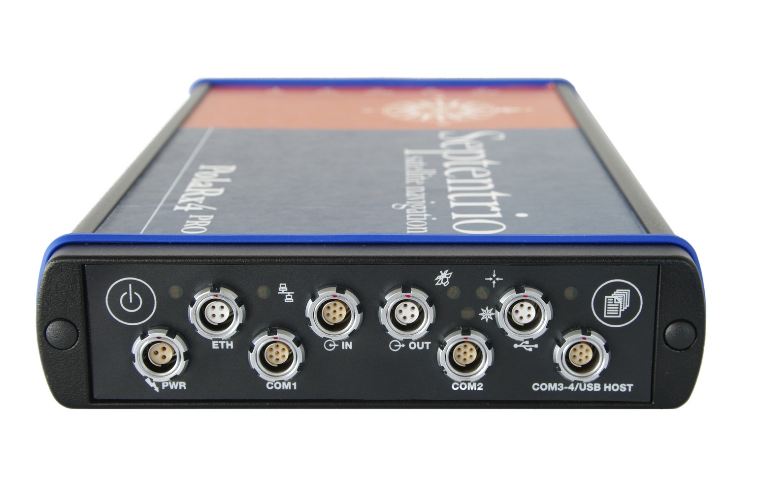
    The Septentrio PolaRx4 reference receiver.
    The Septentrio PolaRx4 reference receiver.

    Veripos, a global provider of precise satellite positioning solutions to the international offshore and marine industries, is concluding the upgrade of its global network of GNSS reference stations with high-performance multi‑frequency GPS/GLONASS/Galileo/BeiDou receivers from Septentrio.

    Veripos owns and operates a network of more than 80 reference stations worldwide that is used to determine estimates of the orbit and clock errors of multiple GNSS satellite constellations. Veripos uses these estimates to calculate corrections which are then broadcast to end users to significantly improve the accuracy of positioning. At the heart of the network is Septentrio PolaRx4, a full-featured reference receiver that provides high-quality tracking and measurement of all available and upcoming GNSS signals.

    The upgrade of the Veripos global network of reference stations with the latest Septentrio reference receiver technology is an outcome of the multi-year collaboration between the two companies. Septentrio also supplies Veripos with multi-frequency GNSS and heading receivers for its marine business, including the LD series of integrated mobile units that deliver the complete range of Veripos augmentation services to its customers worldwide.

    “Septentrio reference stations are renowned for their excellent data-quality and robustness,” commented Bobby Johnson, Chief Technical Officer of Veripos. “Septentrio technology enables us to provide a full range of services and to remotely manage and upgrade the hardware to enhanced features, which is crucial for managing a worldwide reference network, where the equipment is often not easily accessible.”

    “We are delighted to see continued positive outcome from the technical and commercial relationship we have established with Veripos over the years and that has developed into Septentrio enabling Veripos to deliver a variety of solutions with high-quality and robust industrial performance everywhere on the globe to the benefit of a multitude of users in one of the most demanding industries,” said Jan Van Hees, head of sales and business development at Septentrio.

  • Hemisphere GNSS Vector Products Now Have GLONASS Functionality

    Hemisphere GNSS has announced that all professional-level Vector products — including the V103, V113, VS131, and VS330 — now include the ability to utilize the GLONASS system along with GPS in the navigation solution. The tracking of the additional GLONASS signals provides a more robust solution, especially in challenging environments, the company said.

    Vector Technology processes L1 GPS and GLONASS signals to deliver precise heading, greater positioning reliability, and improved performance in challenging environments. Hemisphere GNSS’ patented Vector technology computes the heading and pitch or roll angle while stationary or in motion allowing for heading accuracy of up to 0.01 degrees depending upon the product selected. A variety of differential correction methods also make it possible for Vector products to provide sub-meter to centimeter level RTK position accuracy.

    Professional marine industry organizations can maximize performance by integrating Hemisphere GNSS Professional Vector technology into their systems for hydrographic and bathymetric surveys, autopilots, dredging, and buoys. For land applications, Vector Technology is designed for the alignment of cameras, antennas, and projectiles, and for machine control applications in agriculture, construction, and mining.

  • TomTom Integrates Indoor Mapping with Micello Partnership

    TomTom has begun a strategic partnership with indoor-mapping company Micello Inc., extending its range of mapping products to include indoor venues.

    Integrating Micello’s maps and venue content gives TomTom’s business customers access to accurate pedestrian friendly indoor maps with points of interest data in venues worldwide.

    “The indoor mapping functionality means that step-by-step guidance can be integrated into daily life for a wide variety of venues, including shopping malls, airports and retail stores,” said Charles Cautley, managing director, TomTom Maps. “By partnering with Micello our customers can now develop smarter apps and locations-based services helping users navigate with ease in and out of the car.”

    “We’re excited to be partnering with TomTom, the global leader in navigation.” added Ankit Agarwal, CEO of Micello. “Our agreement means that TomTom’s business customers can use our indoor venue maps and incorporate the content into their automotive, online, or mobile solutions.”


  • Harris Corp. Completes Space Qualification Testing of Hosted Payload for Global Aircraft Tracking System

    Harris Corporation has achieved a key milestone under a five-year contract with Aireon LLC that will create the first global satellite-based aircraft tracking system. The announcement was made during the SATELLITE 2014 Conference and Exhibition, held March 10-13 at the Washington Convention Center in Washington, D.C.

    The company’s Automatic Dependent Surveillance-Broadcast (ADS-B) 1090 Extended Squitter receiver payload has been successfully tested and qualified for simulated operation in the harsh environment of space for more than 12 years. Simulated performance testing also validated the agility of the payload to adapt to evolving aircraft traffic patterns over the same span of time.

    Harris is providing Aireon with 81 of the ADS-B receiver payloads. They will be hosted on board the Iridium NEXT satellite constellation to enable precise aircraft tracking that will optimize air traffic management around the world. Ground-based ADS-B networks, which process GPS signals and other data from aircraft, are limited by an infrastructure that cannot monitor flights over oceans or remote regions, a limitation now highlighted by the disappearance of a Malaysia Airlines jetliner on March 8.

    The Harris payloads are based on the company’s AppStar reconfigurable payload platform. They will be mounted on 66 low Earth-orbiting satellites, six on-orbit spares and nine ground spares that comprise the Iridium NEXT constellation. The air traffic surveillance function will be performed separately from the main mission of the spacecraft. The constellation’s main mission is providing voice and data coverage to satellite phones, pagers and integrated transceivers over Earth’s entire surface. The launch of the first Iridium NEXT satellite is planned for 2015.

    “Completion of this testing verifies that our payload design works for its intended environment and moves us into the production phase,” said Bill Gattle, vice president and general manager, National Programs, Harris Government Communications Systems. “This program exemplifies the benefits of a public-private partnership model, using commercially hosted payloads to get both government and commercial mission capabilities into space without the time and cost required to build and launch separate satellites.”

    “Harris has met or exceeded all of the major milestones in the development and test of the receiver payload for this groundbreaking program,” said Don Thoma, president and CEO, Aireon. “The combined, powerful offering our collective organizations will provide to the global air traffic community will transform air travel.”

  • FOSS4G Europe Conference Set for July

    The FOSS4G (Free and Open Source for Geospatial) Europe Conference, Europe’s largest ever event on free geospatial and location-based software, will be held at Jacobs University in Bremen, Germany, from July 15 through 17, 2014. Also at this conference, the winners of the NASA World Wind Europa Challenge will present their innovative apps to the public.

    More than 500 delegates are expected. The FOSS4G-Europe conference not only attracts software developers and open-source service companies, but also industry and governmental agencies, who increasingly recognize the value and cost savings potential of open-source software. “We are proud and excited to have the honour of organizing the first pan-European FOSS4G,” said Conference Chair Prof. Dr. Peter Baumann, head of the Large-Scale Scientific Information Systems (L-SIS) Research Group at Jacobs. Adds Organizing Committee Chair and L-SIS group member Susanne Ebrecht, “This event actually will contribute to bridging gaps between open-source and commercial software worlds.” The main financial support is coming from the transatlantic Big Geo Data initiative, EarthServer, funded by the European Commission. Additionally, sponsors are being invited from industry, government, and other organizations.

    FOSS4G is a conference series held under the auspices of OSGeo, a worldwide acting, independent, nonprofit legal entity established to support the collaborative development of open source geospatial software and promote its widespread use. Its international Board of Directors is elected by OSGeo Charter Members, one of whom is Prof. Dr. Peter Baumann. Following an outstandingly successful FOSS4G-CEE, for Central and Eastern Europe, in Bucharest in the summer of 2013, it was decided to widen the scope to a pan-European event next year. With more than 500 participants, this will be the largest event of its kind in history, only surpassed by the global FOSS4G conference. As part of this activity network, continental FOSS4G events are being held in Africa, Asia, and Latin America.

    The NASA World Wind Europa Challenge is an annual programming competition organized by NASA, Patrick Hogan, and Prof. Maria Brovelli, University Como, Italy. The challenge is to develop solutions that serve the spatial data needs of the European Community and respond to the INSPIRE Directive. Solutions sought will use NASA’s World Wind, an open-source virtual globe like Google Earth. Data used should relate to INSPIRE, the Infrastructure for Spatial Information in Europe. Examples of applications include a wildfire management tool, a tool for urban management, and tools for weather display and climate research.

    The term free and open-source software denotes computer programs that, together with their blueprint (called the program’s source code), can be distributed without ownership limitations and can be modified and improved by anybody. This prevents from software vendor dependencies and typically leverages resources from developer communities whose passion it is to continuously improve freely available software. As universities frequently are engaged in open-source projects, it is not uncommon that such projects actually define the state of the art. Prominent examples include the Apache Web server and the rasdaman array database system.

  • Do You Know OPUS Can Do This?

    I recently was involved in a project outside of the United States. Part of the project involved setting up a couple of RTK base stations. Of course, I wanted the antenna surveyed with reasonable accuracy with respect to ITRF. Even though supporting OPUS outside of the U.S. is out of the scope of the NGS mission (I assume), it works the same outside of the U.S. as it does within the U.S. Ok, somewhat the same.

    As you imagine, the network of GPS reference stations outside of the U.S. is not nearly as dense as within the U.S., so you can remove OPUS-RS from the discussion immediately. OPUS-RS only requires a minimum of 15 minutes of data, but there must be three GPS reference stations within 250 km that form a polygon around your occupation point. Obviously, in many parts of the world, you aren’t going to be in a location that meets those specifications. Those requirements can be difficult to meet even in the United States. I recall a project on the West Coast where I had plenty of GPS reference stations within 250 km, but because I was near the Pacific Ocean, I wasn’t within the polygon of three GPS reference stations that OPUS-RS could find.

    Back to my ex-U.S. project. With OPUS-RS being out of the consideration, OPUS-S was my choice. What you may not know is that OPUS doesn’t just look at CORS inside the U.S. when post-processing GPS data. It also looks at IGS Stations, which are located all over the world. Granted, I knew the distance to the GPS reference stations would be long, perhaps many hundreds of kilometers to each one, so I planned for long occupation times. This was easy because I was setting up high-quality (choke-ring) permanent antennas on building roofs. I set the GPS receiver to log data overnight at 15-second intervals.

    I apologize ahead of time for needing to hide some of the data in order to preserve the privacy of my client, but you can try this same exercise on data you collect, or grab data from an IGS station and chop it into smaller pieces to process.

    I logged data for about seven hours. Of course, I had ants in my pants, so I didn’t wait for the rapid orbits (used ultra-rapid), but knew I could reprocess at a later date and use rapid and precise orbits. Here’s what I got:

    SOFTWARE: page5  1209.04 master51.pl 072313      START: 2014/01/30  13:49:00
    EPHEMERIS: igu17774.eph [ultra-rapid]              STOP: 2014/01/30  20:59:30
     NAV FILE: brdc0300.14n                        OBS USED:  3219 / 10519   :  31%
     ANT NAME: NONE            NONE             # FIXED AMB:    39 /    56   :  70%
    ARP HEIGHT: 0.0001                           OVERALL RMS: 0.015(m)
     
    REF FRAME: IGS08 (EPOCH:2014.0814)
    X:      xxxxxxx.203(m)   0.396(m)
    Y:      xxxxxxx.943(m)   0.287(m)
    Z:      xxxxxxx.554(m)   0.173(m)
     
    LAT:  xx xx xx.xxxxx      0.122(m)
    E LON:  xxx xx xx.xxxxx      0.470(m)
    W LON:   xx xx xx.xxxxx      0.470(m)
    EL HGT:          387.047(m)   0.212(m)
     
    BASE STATIONS USED
    PID            DISTANCE(m)
    xxxxxx       3125832.0
    xxxxxx      3743350.2
    xxxxxx      3756756.5
     
    Not bad, considering the monster baselines. Yes, that’s 3+ million meters.
    I ran the same data set later with better orbits available, as well as more GPS reference data became available.
    SOFTWARE: page5  1209.04 master53.pl 072313      START: 2014/01/30  13:49:00
    EPHEMERIS: igr17774.eph [rapid]                    STOP: 2014/01/30  21:13:00
    NAV FILE: brdc0300.14n                        OBS USED: 15218 / 16133   :  94%
    ANT NAME: NONE            NONE             # FIXED AMB:    74 /    87   :  85%
    ARP HEIGHT: 0.000011                         OVERALL RMS: 0.013(m)
    REF FRAME: IGS08 (EPOCH:2014.0814)
          
    X:      xxxxxx3.383(m)   0.008(m)
    Y:      xxxxxx1.704(m)   0.026(m)
    Z:      xxxxxx9.425(m)   0.013(m)
    LAT:  xxx xx xx.xxxxx      0.006(m)
    E LON:  xxx xx xx.xxxxx      0.015(m)
    W LON:  xxx  xx xx.xxxxx      0.015(m)
    EL HGT:          386.851(m)   0.025(m)

    BASE STATIONS USED

    xxxxxx        271186.8
    xxxxxx      1277894.3
    xxxxxx        978536.0
     

    Wow, the baselines sure improved, and that’s reflected in the solution. That’s because the GPS reference data isn’t immediately accessible from some IGS Stations. In the interest of privacy, I erased the Lat/Lon but kept the elevation. You can see the elevation difference between the two is about 20 cm. I assume it’s an improvement. For confirmation, I decided to run the same dataset through Australia’s AUSPOS online processing service.

    X:      xxxxxx3.390(m)   0.008(m)
    Y:      xxxxxx1.676(m)   0.006(m)
    Z:      xxxxxx9.405(m)    0022(m)
     
    LAT:  xxx xx xx.xxxxx      
    E LON:  xxx xx xx.xxxxx      
    W LON:  xxx  xx xx.xxxxx     
    EL HGT:          386.822(m)

    The results were comparable to the OPUS solution, differing by 0.7cm in X, 0.08cm in Y and 2.9cm in Z.

    AUSPOS used substantially more GPS reference stations (14 total) than OPUS:

    STATION, Positional uncertainties (95%) for X, Y, Z (in meters)

    XXXX , 0.012, 0.008, 0.016
    XXXX, 0.008, 0.005, 0.013
    XXXX 0.006, 0.005, 0.013
    XXXX 0.009, 0.006, 0.021
    XXXX 0.007, 0.005, 0.013
    XXXX 0.006, 0.005, 0.012
    XXXX 0.006, 0.005, 0.013
    XXXX 0.006, 0.005, 0.013
    XXXX 0.009, 0.005, 0.015
    XXXX 0.006, 0.005, 0.013
    XXXX 0.007, 0.006, 0.013
    XXXX 0.006, 0.006, 0.013
    XXXX 0.006, 0.006, 0.012
    XXXX 0.008, 0.005, 0.015

    Baseline distances ranged from 341 km to 3,700 km.

    So, do I believe the OPUS solution or AUSPOS solution? I split the difference at the time. However, I set up the GPS reference stations in such a way that I can access them remotely and log data at any time from my laptop computer, so I’m running a series of eight-hour (or whatever in convenient) occupations and processing them through both services. So yes, OPUS is an international service (shsh, don’t let the bureaucrats and politicians know).

    Thanks, and see you next month.

    Follow me on Twitter.

  • FAA Enforcement Action Dimissed against Commercial Drone User

    March 7, 2014 Update: WASHINGTON, D.C.–The Federal Aviation Administration today issued a notice appealing a decision by an NTSB Administrative Law Judge in the civil penalty case, Huerta v. Pirker. “The FAA is appealing the decision of an NTSB Administrative Law Judge to the full National Transportation Safety Board, which has the effect of staying the decision until the Board rules. The agency is concerned that this decision could impact the safe operation of the national airspace system and the safety of people and property on the ground.”

    ————————————

    PirkerCover

    On March 6, 2014, Federal Judge Patrick Geraghty dismissed a case the Federal Aviation Administration (FAA) brought against Raphael Pirker, accusing Pirker of illegally using a drone to make a video of the University of Virginia. The FAA attempted to levy a fine of $10,000 against Pirker, described in an article published in Geospatial Solutions in December 2013.

    Brendan Schulman, Pirker’s attorney, told Geospatial Solutions, “The FAA’s position on this is based on a policy statement, not an enforceable regulation.”

    Judge Geraghty agreed, stating the following in his finding (download the PDF):

    1. Neither the Part 1, Section 1.1, or the 49 U.S.C. Section 40102(a)(6) definitions of “aircraft” are applicable to, or include a model aircraft within their respective definition.

    2. Model aircraft operation by Respondent was subject only to the FAA’s requested voluntary compliance with the Safety Guidelines stated in AC 91-57.

    3. As Policy Notices 05-01 and 08-01 were issued and intended for internal guidance for FAA personnel, they are not a jurisdictional basis for asserting Part 91 FAR enforcement authority on model aircraft operations.

    4. Policy Notice 07-01 does not establish a jurisdictional basis for asserting Part 91, Section 91.13(a) enforcement to Respondent’s model aircraft operation, as the Notice is either (a) as it states, a Policy Notice/Statement and hence non-binding, or (b) an invalid attempt of legislative rulemaking, which fails for non-compliance with the requirement of 5 U.S.C. Section 533, Rulemaking.

    5. Specifically, that at the time of Respondent’s model aircraft operation, as alleged herein, there was no enforceable FAA rule or FAR Regulation applicable to model aircraft or for classifying model aircraft as an UAS.

    Upon the findings and conclusions reached, I hold that Respondent’s Motion to Dismiss must be AFFIRMED.

    IT IS ORDERED THAT:

    1. Respondent’s Motion to Dismiss be, and hereby is: GRANTED

    2. Complainant’s Order of Assessment be, and hereby is: VACATED AND SET ASIDE

    3. This proceeding be, and is: TERMINATED WITH PREJUDICE.

    ENTERED this 6th day of March, 2014, at Denver, Colorado.

    Patrick G. Geraghty
    Judge
  • Javad Ashjaee Talks GNSS

    Javad Ashjaee Talks GNSS

    Javad Ashjaee
    Javad Ashjaee

    On Thursday, March 20, CEO Javad Ashjaee of JAVAD GNSS will conduct a free webinar on the current state-of-the art in high-precision GNSS technology: Where is high-precision GNSS today? Where is it headed?

    Further topics include new products and solutions from JAVAD GNSS, U.S. sales and customer-support news, and the offer of a two-week free trial for professional land surveyors of the JAVAD GNSS’s newest equipment, the TRIUMPH-LS and TRIUMPH-2. There will also be a question and comment session with one of the industry’s most accessible CEOs. Register here.

    The 75-minute free webinar starts at 1 p.m. Eastern U.S. Time,  10 a.m. Pacific.

  • Topcon Adds Apps, Expands TopNETlive Service

    Topcon Positioning Group has added two new mobile applications to the Apple App Store.  Topcon Tierra and Sitelink3D mobile apps are designed to offer on-the-go remote connections to equipment and job sites.

    The Topcon Tierra mobile app lets customers login with their existing passwords and track their equipment fleets from an iPhone or iPad. “The Topcon Tierra app allows users to easily check on their fleets, fences, productivity reports and get alerts any time, anywhere,” said Kris Maas, construction products marketing manager.  The Topcon Tierra mobile app is available to download at no charge.

    Customers can also manage and monitor job sites with the new Topcon Sitelink3D mobile app. “The Sitelink3D app lets users visualize real-time project management information on their iPhone or iPad with their existing Sitelink3D logins,” said Maas. “Remote connection to equipment within Sitelink3D is easier than ever with the addition of the app.” The Sitelink3D mobile app is available for purchase on the Apple App Store.

    TopNETlive Expands. Topcon Positioning Group also announced the expansion of its TopNETlive network service into 19 states and five Canadian provinces. TopNETlive uses a dense network of ground-based reference stations capable of supporting all major GNSS satellite constellations to provide high-accuracy with fast initialization time.

    The 24 states and provinces now included in the service are Alabama, California, Connecticut, Delaware, Georgia, Illinois, Indiana, Maine, Maryland, Massachusetts, Mississippi, New Hampshire, New Jersey, New York, Pennsylvania, Rhode Island, Vermont, Virginia, Wisconsin, Ontario, New Brunswick, Newfoundland, Nova Scotia and Quebec.

    “TopNETlive network service is a primary source for all levels of correction for users in the agriculture, construction, surveying, civil engineering and GIS industries,” said Jonathan Ball, senior manager for Topcon network business. “It is designed to support all makes and models of GNSS and guidance equipment, making it a logical choice for companies that use multiple brands of positioning equipment.”  Ball further states that, “TopNETlive offers many different subscription plans to fit the operations and the budget of almost any user.”

  • Spectracom Begins Program for Application-Specific Testing

    Spectracom Begins Program for Application-Specific Testing

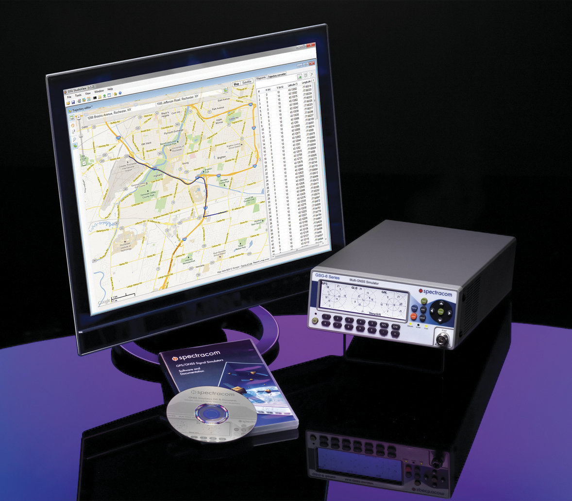
    Spectracom’s GSG-6 Simulator with monitor.
    Spectracom’s GSG-6 Simulator with monitor.

    Spectracom has begun a program to develop robust application-specific testing solutions. The program fills what the company calls a technology and expertise gap in providing customers in a variety of industries the tools to perform more comprehensive qualification of their mission-critical systems. Examples of these industries include:

    • multi-constellation (GPS, GLONASS, Galileo, BeiDou) simulation;
    • integrated MEMs/INS testing;
    • interference detection and mitigation (IDM) verification;
    • assisted-GNSS (A-GPS) validation,
    • hardware-in-the-loop (HIL) testing for automotive applications;
    • high-dynamic platform simulations for aerospace and defense (UAVs, UASs); and
    • precision agriculture/surveying testing via RTK/differential measurements.

    “Our full featured platform of multi-GNSS simulation capabilities  combine flexible hardware and user oriented software to deliver  the functionality and user interfaces necessary for today’s demanding test scenarios,” said Spectracom CTO, John Fischer. “We understand, however, that even the most powerful tools often need something more to reduce complexity, increase productivity and ensure consistent, reliable results. Toward these ends we are excited to bring our extensive applications knowledge directly to our customers to design and deliver custom configurations and test systems that are unique to their applications.”

    Today’s PNT applications combine data from a variety of receivers, sensors and other sources. Spectracom is designing its solutions to integrate simulated GNSS RF with all other data sources in the test system for true “hardware-in-the-loop” verification, the company said.

    For instance, Spectracom’s new assisted-GNSS (A-GNSS) feature is designed to integrate with 3GPP/LTE testers to send “assistance data” directly to the device under test. The company takes a similar approach to testing RTK-enabled receivers with user-settable virtual base-station parameters.

    “Spectracom’s value is to partner with our customers to ensure they have the ability to easily use GNSS simulation as part of a comprehensive PNT testing solution,” said Rohit Braggs, Director of Marketing and Strategy. “More testing in the lab enables faster time to market, at a reduced cost and increased reliability. We are asking developers of the most demanding PNT applications to put us to the test.”