The Collector for ArcGIS app can be used offline to collect and edit maps and data regardless of network availability.
Esri has released new versions of Collector for ArcGIS and Operations Dashboard for ArcGIS. The Collector app now includes the ability to download maps to your smartphone or tablet device to collect and edit data when working offline. Operations Dashboard has added support for browsers so users can view operations on their iPad, Android tablet, or from their desktop. Both apps are available at no cost to ArcGIS Online subscribers and Portal for ArcGIS customers.
Collector for ArcGIS is a configurable field data collection app for iOS and Android devices. With the latest release, maps can be used anywhere regardless of network availability. Users can take map areas offline and work with them in remote locations where network availability is either nonexistent or unreliable. Users can download Esri basemaps as well as their own basemaps managed within their ArcGIS organization.
Operations Dashboard for ArcGIS provides a common operational picture for monitoring, tracking, and reporting events within your organization. The new version of Operations Dashboard now supports web browsers. That means you can have the same real-time view of operations on your tablet that you see on your Windows desktop.
Data sources inside Operations Dashboard have also been improved in the 10.2.2 version of the app. Users can now power operation views using dynamic map services as well as feature services, and other types of layers including real-time weather, traffic, and social media feeds.
Collector for ArcGIS can be downloaded from the Apple App Store and Google Play. Operations Dashboard is available through ArcGIS Online. Portal for ArcGIS users can access the Operations Dashboard app from the Customer Care portal.
Signal Sentry 1000, an Exelis product that detects and locates GPS interference sources in 3D by using longitude, latitude and altitude, was deployed during Super Bowl XLVIII at the MetLife Stadium in East Rutherford, New Jersey.
During the Super Bowl, GPS devices were used extensively to track and monitor the location of team members and officials. GPS was also used to ensure that event organizers and security knew the exact location of team vehicles en route to the stadium. If a vehicle were to break down delaying the arrival of a team or game staff to the event, logistics and scheduling could have been adjusted accordingly.
“Signal Sentry 1000 helped our law enforcement officials keep thousands of fans in attendance safe during one of the most exciting nights for millions of Americans,” said Mark Pisani, vice president and general manager of positioning, navigation and timing for Exelis Geospatial Systems. “Protecting critical GPS infrastructure is extremely important for public safety.”
Signal Sentry 1000 was designed to collect actionable intelligence for law enforcement and to protect GPS signal-dependent critical infrastructures. At the Super Bowl, Exelis deployed eight Signal Sentry sensors positioned in an array pattern to detect and locate the jamming source. Threats are detected through a network of sensors, which is part of a centralized server executing Exelis-developed proprietary location algorithms.
In addition to national special security events like the Super Bowl, sensors can also be used around different types of critical infrastructure, such as utilities and government facilities, to automatically sense and locate any intentional or unintentional source of GPS jamming. Once a threat is detected, users receive specific information regarding the location of the threat in order to stop or mitigate the interference.
The European Navigation Conference (ENC) will be held April 15-17, 2014, in the World Trade Center in Rotterdam, The Netherlands. The conference aims at technology, innovation, and business in the PNT domain (positioning, navigation, and timing). The conference program is now available for review online.
Satellite navigation and positioning, using current operational systems like GPS and GLONASS, will be major topics. The conference will also highlight recent developments on emerging GNSS like the European Galileo and the Chinese BeiDou.
More than 100 presentations will be given at ENC GNSS 2014. Here are a few highlights:
Keynote speeches
Prof. Bradford Parkinson (Stanford University): Assured PNT – assured world economic benefits.
Prof. Erik Theunissen (Netherlands Defence Academy): So you think you are safe.
Invited lectures
Prof. Cathryn Mitchell (University of Bath): Space weather effects on GNSS.
Ignacio Fernández-Hernández (European Commission): The Galileo commercial service: current status and prospects.
Jaron Samson (European Space Agency): An introduction to interference in GNSS bands.
Prof. Peter Teunissen (Curtin University/Delft University of Technology): Multi-GNSS: combining GNSSs for precise positioning and navigation.
Prof. Frank Van Graas (Ohio University): Disruptive technologies and GNSS aircraft landings.
Prof. Qile Zhao (Wuhan University): Positioning performance and precise applications of Beidou navigation satellite system.
Special sessions
The European Space Agency will organize a dedicated session on Galileo IOV results.
Anwendungszentrum GmbH Oberpfaffenhofen (AZO) will chair the kick-off meeting of the European Satellite Navigation Competition 2014.
Prior to the conference, on April 14, there will be a Resilient PNT forum and a meeting of the European Maritime Radio Forum (EMRF).
DigitalGlobe, Inc., has launched a crowdsourcing campaign that will allow anyone to help look for the missing Malaysia Airlines flight MH370 by combing through satellite images for clues of its whereabouts.
The search drew so many participants on its first day March 17, that it crashed the company’s website, with 500,000 visitors wanting to help find the missing Boeing 777. Anyone can begin searching the satellite images, tagging anything that looks suspicious. Each pixel on a computer screen represents half a meter on the ocean’s surface.
The Longmont, Colorado, company said two of its commercial satellites have already collected images comprising roughly 1,988 square miles at the confluence of the Gulf of Thailand and the South China Sea, where the Beijing-bound aircraft mysteriously went missing on Saturday. The company is continuing to update the images to reflect new information about the search area provided by the Malaysian government.
To help, go to DigitalGlobe’s crowdsourcing website, Tomnod.com.
DigitalGlobe, Inc., has launched a crowdsourcing campaign that will allow anyone to help look for the missing Malaysia Airlines flight MH370 by combing through satellite images for clues of its whereabouts.
The search drew so many participants on its first day March 17, that it crashed the company’s website, with 500,000 visitors wanting to help find the missing Boeing 777. Anyone can begin searching the satellite images, tagging anything that looks suspicious. Each pixel on a computer screen represents half a meter on the ocean’s surface.
The Longmont, Colorado, company said two of its commercial satellites have already collected images comprising roughly 1,988 square miles at the confluence of the Gulf of Thailand and the South China Sea, where the Beijing-bound aircraft mysteriously went missing on Saturday. The company is continuing to update the images to reflect new information about the search area provided by the Malaysian government.
To help, go to DigitalGlobe’s crowdsourcing website, Tomnod.com.
Chartered Land Surveyors from the Upper Savoy region in France set up a Leica Nova MS50 MultiStation to take a 3D scan of the Mont Blanc ice cap and also a Leica Viva GS14 GNSS antenna to measure the mountain’s elevation.
Reaching the top of Mont Blanc, Europe’s highest peak, is a formidable challenge even to the most experienced alpinists — not only because of its elevation, but also because of its weather conditions. Strong winds and snowfall at the summit constantly cause altitude changes to the summit’s ice and snow cap. Such changes motivate expert surveyors to try out the latest in measurement technology, like the Chartered Land Surveyors located in the Upper Savoy region in France as well as two surveyors from Leica Geosystems France. For their seventh expedition, they decided to make the first ever 3D laser scan of the shape and volume of this legendary glacier using the Leica Nova MS50 MultiStation.
Toward the end of 2013, surveyors braved temperatures of -10⁰ C and winds of over 50 km/h,and set up a Leica Viva GS14 GNSS antenna to measure the height and also take roughly 100 point measurements of the ice cap. The Leica MS50 MultiStation scanned the ice cap at an altitude of over 4,800 meters under extreme conditions and recorded thousands of points in a matter of minutes.
The 2013 expedition proved that the current elevation of Mont Blanc is 4,810.02 meters, which is 42 centimeters less than in 2011. The actual rock summit has an altitude of 4792 meters; however, the snow covering the peak may vary the actual summit’s altitude anywhere from 15 to 20 meters. Expedition partner Géomédia calculated the volume of the ice cap covering the rocky summit at 20,213 m³ and produced a 3D animation from the scan data as well. In the future, these results will help researchers determine possible changes to the ice cap caused by global warming.
“Using the Leica Nova MS50 MultiStation to make a 3D model of the biannual Mont Blanc summit expedition was a challenging exercise that resulted in highly accurate data,” said Philippe Borrel, owner of the surveying company Cabinet Borrel and an experienced member of the expedition team. “Collecting data under such extreme conditions quickly and efficiently is extremely important. This time, we were able to reduce time expenditure needed to complete the task. The MultiStation was surprisingly easy to carry in a backpack, considering the rocky terrain, steep slopes and windy ridges we had to climb.”
Airbus Defence and Space has mobilized five observation satellites to aid in the search for the missing Malaysian Airlines plane. The Boeing 777 disappeared on March 8 during a flight from Kuala Lumpur to Beijing.
The day after the aircraft disappeared,the very high-resolution Pléaides 1A and 1B satellites, the high-resolution SPOT 5 and 6 satellites, and the synthetic aperture radar satellites TerraSAR-X were programmed to take images of the search zone. All the data collected are analyzed by Airbus Defence and Space maritime experts and provided to the Malaysian Remote Sensing Agency (MRSA).
The Pléiades images are also transferred via CNES, and TerraSAR-X images via DLR, to the Chinese Meteorological Administration, which requested the Disaster Charter activation on March 11.
Since Sunday, March 9, the experts of Airbus Defence and Space have been analyzing the images taken by the optical and radar satellites. The radar satellites like TerraSAR-X are able to identify layers of hydrocarbon as well as any oil slick or metallic objects floating on the sea. The resolution of the optical satellites Pléiades 1A & 1B (50 cm after resampling) and SPOT 5 and 6 allow for identification and characterization of small objects over large surfaces.
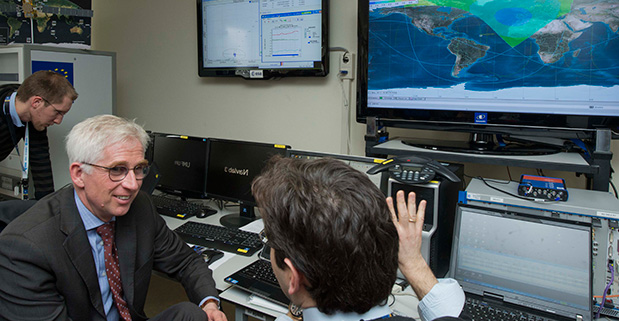
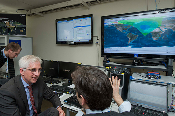
Javier Benedicto, ESA’s Galileo Project Manager, looks on as Europe’s own satellite navigation system performs its historic first position fix of longitude, latitude and altitude. The position fix took place at the Navigation Laboratory at ESA’s technical heart ESTEC, in Noordwijk, the Netherlands on the morning of March 12, 2013, with an accuracy between 10 and 15 meters — expected taking into account the limited infrastructure deployed so far. Horizontal accuracy reached as high as 6 m. The left-side screen shows the position fix while the right side screen shows the position of the four Galileo satellites and their current signal coverage.
Did you get a fix on four Galileo satellites? Then there could be a certificate in it for you! ESA will recognize Galileo pioneers with commemorative certificates to the first 50 entities who document their achievement of a past or present fix. Details of how to apply are provided here.
To mark the first anniversary of Galileo’s historic first satnav positioning measurement, ESA plans to award certificates to groups who picked up signals from the four satellites in orbit to perform their own fixes.
In 2011 and 2012 the first four satellites were launched — the minimum number needed for navigation fixes.
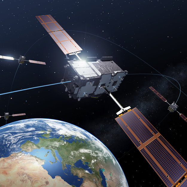
Europe’s Galileo satnav system.
On March 12, 2013, Galileo’s space and ground elements came together for the first time to perform the historic first determination of a ground location — the Navigation Laboratory of ESA’s Technical Centre in Noordwijk, the Netherlands.
From this point, generation of navigation messages enabled full testing of the entire Galileo system — not just by ESA and its industry and institutional partners but also by any entity with a customized satnav receiver.
ESA’s Galileo team has heard about position fixes carried out by organizations and companies all over Europe and beyond, including as far away as Vietnam.
A year after the first fix, ESA is recognizing these Galileo pioneers with commemorative certificates to the first 50 entities who document their achievement of a past or present fix.
Applicants should send in their name, address, details of the receiver they used, the start and end time of their fixes in Universal Time Coordinated (UTC) and a plot of their latitude/longitude position fixes overlaid on a map, such as Google Earth. Submissions should be sent to [email protected] within the next two months. Certificates will be sent out after May 12, along with an online results update. See details of how to apply here.
The first Galileo services are scheduled to begin later this year, as more satellites are delivered into orbit. The next launches will occur in the second half of this year, each with two satellites aboard a Soyuz ST-B. They will take place in close succession to build up the constellation.
Many satnav receiver chips are already technically Galileo ready, requiring only software upgrades from their manufacturer to begin working with Galileo signals along with GPS and other international satnav systems.
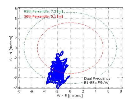
Dual-frequency Galileo positioning performance during the In-Orbit Validation phase: positioning accuracy is an average 8 m horizontal and 9 m vertical (95% of the time). Its average timing accuracy is 10 nanoseconds on average. Plot courtesy of ESA.
Topcon Positioning Group announces two new updates for MAGNET Enterprise — the cloud-based solution for managing field and office data in a web browser environment. New to the system is the introduction of MAGNET Enterprise Mobile, an application for mobile devices, as well as new project management functions.
MAGNET Enterprise Mobile is designed to allow users to take the central hub of the MAGNET system of solutions with them on the go. Oscar Cantu, Topcon software marketing manager, said, “The MAGNET Enterprise Mobile app takes the powerful software solution for exchanging data between the office and field through a cloud-based Company Account and puts it in the pocket of the user for easy access wherever they travel.” The app is available on the Apple App Store for iPhones and iPads.
Another addition for both the full web browser solution, as well as the mobile version of MAGNET Enterprise, is the introduction of new project manager extensions. Customers will have new functions for coordinating and overseeing their projects including: an overview dashboard for all active projects, a proposal writing and task-creation operation, task assignments, a project-specific dashboard, project calendar, project status reports, and user schedule and timecard applications.
“MAGNET Enterprise has proven itself as an ideal solution for project managers overseeing the progression of multiple projects, managing company assets, safely storing and retrieving project related files and orchestrating daily efforts within their secure cloud-based Company Account. Now, with the addition of these tools, MAGNET customers will meet deadlines, gain productivity and collaborate like never before,” said Cantu.
“The project management oriented functionality, coupled with the introduction of the MAGNET Enterprise Mobile app is another step forward in the MAGNET system of solutions that brings together all facets of a company for unmatched collaboration.”
TomTom has today announced its speed cameras service is now available in Brazil. Drivers will benefit from up-to-date warnings of nearby fixed and red light cameras, as well as speed enforcement zones.
Car manufacturers can integrate the service in their in-dash and mobile navigation systems, TomTom said. Backed by OpenLR* technology, TomTom is able to pinpoint more than 17,000 speed cameras across Brazil.
“Drivers in Brazil are now better equipped to make smarter decisions on every journey, keeping to the designated speed limit and avoiding costly fines,” commented Ralf-Peter Schaefer, VP of Traffic at TomTom. “The launch of this service adds to the real-time information available to Brazilian drivers; TomTom recently launched its world-class traffic information in Brazil, helping drivers avoid frustrating traffic jams and reach their destination faster.”
MicroSurvey announces the release of MicroSurvey inCAD 2014 and MicroSurvey embeddedCAD 2014.
MicroSurvey inCAD 2014 is a plugin that transforms AutoCAD into a survey and design powerhouse, MicroSroSurvey said. It adds the MicroSurvey feature set to the latest Autodesk software — including AutoCAD 2014, AutoCAD Civil 3D 2014, and AutoCAD Map 3D 2014 — to offer a complete survey drafting toolkit, including COGO, DTM, traversing, adjustments, volumes, contouring and more.
MicroSurvey embeddedCAD 2014 is a standalone application powered with Autodesk technology that includes the latest AutoCAD OEM 2014 enhanced with the suite of MicroSurvey tools. Like inCAD 2014, it incorporates the full suite of survey drafting tools. MicroSurvey embeddedCAD 2014 includes a licensed copy of AutoCAD OEM 2014, and it opens and saves AutoCAD 2014 drawing files, so implementing it in existing AutoCAD environments is without conflicts.
Both releases are built specifically for the demanding needs of land surveyors, contractors and civil engineers, and include many new features requested directly from customers. “Several years ago we implemented a transparent and easy to use online feedback forum where our customers could submit their ideas and suggestions for improvements to our products,” said Darcy Detlor, president of MicroSurvey. “The feedback system lets our users propose their feature requests and allows them to cast votes on any request that has been submitted. Requests with the most votes are given the highest priority and get our attention, ensuring that we are working on features that our customers really want.”
MicroSurvey focused its development efforts on adding several new geodetic tools, hundreds of new coordinate systems, and geoid files. Users can now store and edit points using their latitude and longitude values, view combined scale factors and convergence angles at any point in their drawing or project database, and transform between ellipsoidal and orthometric elevations using geoid files. Other powerful new productivity tools include a 2D draw mode for creating a 2D drawing while maintaining 3D elevation data, as well as rescaling tools for changing the base drawing unit of an entire drawing or specific text.
Both MicroSurvey inCAD 2014 and MicroSurvey embeddedCAD 2014 are available in two feature levels — Premium and Standard — giving users the choice between two tiers of features to ensure they are getting precisely what they need.
Free trial versions of the software can be downloaded from the MicroSurvey website.
A still from the movie Gravity, where space real estate feels really small and collisions frequently happen. (credit: Warner Bros. Pictures)
Wow, what a bevy of acronyms. If you already know what they mean, great. If you don’t, just hang in and all will be made clear.
E. L. Doctorow once wrote, “Writing is a socially acceptable form of schizophrenia.” Now, I am not sure how I feel about that or how my daughter who is a practicing Clinical Psychologist (PsyD) would interpret that, but as she publishes (publish or perish) behavioral science papers in the public domain, she did remind me of a paradigm shift in journalism today that has stuck with me. She said simply, “Dad, everything you publish today is out there and available to everyone, everywhere, all the time, in multiple venues.” As mundane as that may sound to everyone under 20 years of age, to those of my generation it is indeed profound, as it socially delineates the technical world we live in today that has afforded unprecedented data and document availability for the first time in history. Never before have so many had virtually instantaneous access to so much information. Can you say Siri?
The really interesting part of this instant-access phenomenon is that it not only applies to articles and columns that I and my fellow journalists pen today, but includes access to everything we, and anyone else, has ever written that has been preserved. As you read this, thousands of books (some moldering for more than two thousand years), reports and articles are being scanned daily and made available for the world to read in a digital or new print format.
Numerous major programs today are digitizing books, documents, magazines and newspapers daily, such as Amazon and the sometimes annoying Captcha program, which stands for Completely Automated Public Turing test to tell Computers and Humans Apart. In 2007 the Alfred P. Sloan Foundation awarded the Library of Congress more than $2 million for the “Digitizing American Imprints at the Library of Congress” effort. Thanks to this program and others, such as Project Gutenberg, most of the digitized volumes, 45,000 and counting for Project Gutenberg, include most of the writings of Thomas Jefferson, Benjamin Franklin and George Washington, and they are available online free of charge. Depending on your point-of-view and physical location (think Mainland China, Russia and North Korea) that can either be a scary thought or wonderfully liberating.
For almost everything written and published — and published has a new definition in this context — in the past ten years or so, and certainly for the knowable future, the digital and availability timeline equals immediate access. That is because today almost every written document originates in a digital format, while printing and publishing are secondary actions. Think about how this has changed the way you work and read today. It is truly a major revolution of epic proportions, taking place in an evolutionary manner.
USAF SAB
Recently, I was reminded of this new electronic availability as it concerns an academic paper I was honored to edit and minimally coauthor as the Executive Officer for a very distinguished committee of preeminent scientist and physicists, more than 17 years ago when I served on a USAF (United States Air Force) Scientific Advisory Board, or SAB. I have been honored to serve on several SABs and have written or contributed to several SAB reports, but this one was particularly intriguing albeit esoteric in nature, and unless you were interested in the hazards of space debris at the time, which many of us were, you may never have heard of it until now. The full title of the report is rather lengthy, as is common with scholarly scientific reports:
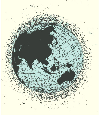
A snapshot of the locations of all cataloged space objects (from the report).
The report was, at the time, and many of us feel today is still, the quintessential and defining document on the hazards or non-hazards of space debris and has been liberally quoted in scientific documents and treatises for the last 17 years.
Meanwhile, NASA (the National Aeronautics and Space Administration) as an organization has always been a bit of a harridan concerning space debris, and it has been known to sensationalize the effects that cascading space debris may have on space assets. Of course, they are always quick to point out that we academics and scientists outside of NASA only worry about absolute numbers and probabilities, while they — as the recent blockbuster movie Gravity amply exemplifies — worry about human lives in an extremely hostile space environment. This is not to say that space debris is not a valid concern; however, this SAB report clearly points out that the NASA cascading theory is more sideshow sensationalism of the Hollywood blockbuster mentality rather than supportable scientific theory. Indeed, space is a very big place, and as Einstein stated, it is always expanding — so you be the judge.
Space Surveillance
But I digress, because for the first time in recent memory, it was not the space debris aspects or Volume Four of the SAB report that made it a document of interest, but rather the First Volume on Space Surveillance that evidently piqued the USAFs interest. In Volume One, the committee made a recommendation (remember, this was seventeen years ago), that to successfully surveil space, you must do it from space and not from the Earth’s surface. Our actual recommendation in part stated, “…the committee recommends that the Air Force pursue surveillance of space from space with search capability.” And then we proceeded to move into tens of pages of technical specifics, which is more than most of you would ever want to take the time to read.
In a nutshell, as it turns out when you surveil space objects, natural and manmade from Earth, you encounter a multitude of bothersome effects you must deal with, such as weather (clouds, storms and lightening — none of which are good for sensitive optical sensors), atmosphere, solar disturbances, signal disturbances, background noise, and more. Now when you surveil space from space, most of these bothersome effects are mitigated to a major degree by the vacuum of space. In the SAB report, in much more detail than I can relate here, we basically concluded that the only successful way to continually monitor and surveil space and objects in space, both natural and man made, is to undertake that surveillance effort from space — in other words, surveil space from space — ideally from a GEO or near Geosynchronous orbit spacecraft with multiple sensors, including multi-spectral sensors that surveil both natural and manmade objects and phenomenon. Seventeen years later it appears that someone listened, and fortunately that someone belonged to an institution, the United States Air Force.
The Secret’s Out
A few weeks ago, General William Shelton, the Commander of Air Force Space Command (AFSPC) announced that by the end of the year, under a program formerly in the SECRET domain known as the Geosynchronous Space Situational Awareness Program, or GSSAP, “…the USAF plans to launch two space surveillance spacecraft into high-altitude orbits later this year to monitor satellite traffic in the congested geosynchronous belt 22,300 miles above Earth…GSSAP will produce a significant improvement in space object surveillance, not only for better collision avoidance but also for detecting threats…GSSAP will bolster our ability to discern when adversaries attempt to avoid detection and to discover capabilities they may have which might be harmful to our critical assets at these higher altitudes.” Shelton made these remarks in a speech at the Air Warfare Symposium in Orlando, Florida, in February.
While these are not the first space surveillance satellites launched by the USAF, they are the first that peer down from on high. Currently the USAF also operates the SBSS or Space Based Surveillance Program, but these satellites surveil all of space from LEO (Low Earth Orbit) altitudes with an optical telescope. Their GEO targets are more than 22,000 miles distant. The newly announced GSSAP satellites will have much more fidelity and have the added advantage of surveilling GEO assets from GEO.
ANGELS and GPS
All very interesting, you say, but where does GPS come into play? Glad you asked. While the GSSAP mission will undoubtedly use limb-of-the-Earth GPS signals for guidance and orientation, the GSSAP mission will also host two other small satellites known as ANGELS, or Automated Navigation and Guidance Experiment for Local Space. The ANGELS job will be to test accelerometers and specialized algorithms that will utilize the GPS navigation signals being broadcast from 11,000 miles away in their MEO orbits, for precision guidance when in close proximity to other satellites, thereby reducing the probability of a collision. Think about this one for a while and all kinds of possibilities become apparent. Why not equip every U.S. satellite with ANGEL technology? Currently, the Air Force fact sheet on ANGELS states that the scope of the mission is limited to the space around the Delta 4 rocket’s upper stage, and while we all know from experience how dangerous inert, non-maneuverable upper stages can be, if you believe the AF fact sheet, I have some swamp land in Florida I would like to discuss.
Seriously, however the GSSAP and ANGELS missions evolve, it is still nice to know that someone is reading what you write, even if it is 17 years later.
Until next time, happy navigating and sleep well, because ANGELS really do exist.
What Is Don Reading?
Obviously I have been reading ancient but still pertinent SAB reports but more importantly this week I also read and highly recommend you read and comment on the latest Federal Register notice for comment submitted by DOT concerning deployment of GPS CNAV messages. The DOT comments are actually a bit misleading as they infer this is an early or pre-operational deployment of CNAV messages and that is a bit of a misnomer. Under the original guidelines CNAV signals would have been broadcast back in 2003 but events prevailed to prevent that from happening. However, and this is an update to the numbers in the original Federal Register Notice, there are currently 12 GPS SVs on orbit capable of broadcasting civilian L2C CNAV signals and military code or MNAV messages. Additionally there are five GPS satellites (IIFs) on orbit capable of broadcasting L5 safety of life signals for DOT.
Frankly, the DOT objects to these signals being broadcast now for, in my humble opinion, very nebulous reasons, and the USAF is working hard to and has, again in my opinion, negated all of the DOTs concerns. So please just take a couple of minutes and go to the Federal Register site and let them know how badly we need these new signals.
Hopefully, you read my February column affirming GPS as the reigning PNT Gold Standard. In order to maintain that status and indeed to continually exceed the capabilities of any of the current or planned PNT systems in existence today, the GPS needs these new signals. I predict CNAV and MNAV messaging capabilities will revolutionize the way PNT signals are utilized. These new signals bring about a capability heretofore unknown in the PNT arena. Just think about this, each CNAV and MNAV signal has the ability to broadcast 256 separate and definable messages to users globally. With 12 CNAV satellites on orbit today, global accessibility tests have shown that for the majority of users this means at least one CNAV SV in view at all times and you only need one CNAV SV in view to take advantage of the messaging capabilities. So the sooner the better I say. I don’t have the room to say much more than that this month but just imagine the possibilities. Please log onto the Federal Register site and let your opinion be heard.