Blog

  • Situational Awareness, New Tech Discussed at Spatial Plexus Conference

    Front

    A Report on the Annual GIS Conference of the Georgia Tech Research Institute (GTRI)

    By Art Kalinski, GISP

    “Plexus is defined as any complex structure containing an intricate network of parts. The Spatial Plexus annual event elevates Geographic Information Science as the cross-disciplinary application of GIS and geo-technologies against so many interconnected issues.” — Spatial Plexus website

    Two weeks ago, I attended Spatial Plexus 2013, a GIS conference put together by Danielle Ayan of GTRI. Her reputation of building well-organized conferences helped draw some very interesting and influential speakers. The conference was held at the historic Academy of Medicine at Georgia Tech in Atlanta. The academy is listed on the National Register of Historic Places and even has a connection to the movie Gone with the Wind. Built before television and movies, the auditorium was designed for doctors to view medical demonstrations using actual cadavers on the stage. Fortunately, none of the Plexus presentations were cadaverously dull.

    Theater-W

    The conference opened with several pre-conference workshops, including Course Development Workshops to advance GIS-related education based on DACUM (Developing A CUrriculuM) and the Geospatial Technology Competency Model (GTCM). This was tied in with a GeoTech Advisory Council Meeting. The GeoTech Center, funded in part by National Science Foundation, is a collaborative effort between colleges, universities and industry to expand the geospatial workforce by providing professional development and curriculum resources.

    A workshop I attended covered new capabilities of ArcGIS Online. The hands-on workshop was conducted by Dr. Tom Mueller of California University of Pennsylvania and Dr. Rich Schultz of Elmhurst College, Illinois. If interested, you can go through the same tutorial online.

    I liked the linear format of this conference rather than separate break-out sessions found in mega conferences, because I always get frustrated missing competing break-out sessions. Additionally, we tend to overly focus on our primary areas of interest to the exclusions of other topics. The linear format pulls your mind and attention through a variety of subject areas, expanding the breadth of your knowledge. That was certainly the case with Spatial Plexus — lots of variety. The following are just a sample of the presentations. You can go to the Spatial Plexus website for a complete list, including many of the presentations and associated SharePoints.

    The opening keynote was given by Daniel Edelson, vice president of education for the National Geographic Society. He discussed “The Importance of Geo Literacy for College, Career and Civic Readiness.” His presentation was reinforced by Dr. Max Baber, the director of academic programs for the U.S. Geospatial Intelligence Foundation (USGIF). He discussed the multitude of excellent positions in the geospatial intelligence community, both at NGA and associated contractors. He also stressed the growing need and demand for GEOINT analyst certification, which is becoming a way to ensure qualified personnel in government and contractor positions.

    Tamarin Gullett-Tyrrell, GIS analyst for Cherokee County, Georgia, demonstrated the county geospatial Situational Awareness website. The Esri/Silverlight system by GeoCortex was designed to serve the public as well as emergency responders. Tamarin and Joe Woycke, Director of GIS and Mapping, built the well thought out and elegant system by bringing together all the county stakeholders early in the process. They determined that the complexity and diversity of stakeholder requirements pointed the way to two separate sites — one for tax work / county planning and the other for the public and emergency responder situational awareness including the sheriff, police, fire departments, EOC and the 911 call center. The early collaboration and consensus building saved a lot of time and expensive change orders. The result is two systems that all users are happy with. Shown below is . It not only incorporates county data and imagery, it toggles Bing and Google geospatial data.

    Situational awareness website SAGE.
    Situational awareness website SAGE.

    Joe Francica, editor-in-chief of Directions Magazine in Huntsville, Alabama, gave a rapid-fire summary of new technology he was following that he believed will impact the geospatial community. These include:

    • WiFiSLAM, an indoor location technology
    • geofencing, which sends location-based notifications to consumers approaching a store
    • connected cars
    • TracDot, a tag that tracks your luggage, and
    • the much-publicized Google Glass.

    He also mentioned my favorite new emerging technology — 3D printers, as well as drones and nano technology. He recommended James McQuivey’s book Digital Disruption: Unleashing the Next Wave of Innovation.

    In one of the open group discussions related to my presentation on Soft Power, I mentioned the 2010 Foreign Affairs magazine article on the disruptive effect of social media and mobile devices on second- and third-world countries. I discussed my amazement at the ingenuity of people who find a way to communicate without the benefit of a well-established communications systems. FabFi is a very low cost and simple wireless network developed by MIT students that is being used in Kenya and Afghanistan to provide wireless communications between villages. The system uses inexpensive $40 off-the-shelf wireless routers and home-made parabolic antennas of plywood and chicken wire to send wireless signals from one village to another. The networks are so quick and easy to establish that governments may no longer have the power to turn off the Internet when they feel threatened. This is democratization at its best.

    The FabFi program brings the Internet to villages in developing nations.
    The FabFi program brings the Internet to villages in developing nations.

    There were several presentations on the use of GIS in medical applications, especially the work being done by the Centers for Disease Control (CDC), and even a presentation by Chris Smith, director of IT Services for the U.S. Architect of the Capitol on how GIS had streamlined the management of Capitol facilities.

    Chris Smith, director of IT Services for the U.S. Architect of the Capitol.
    Chris Smith, director of IT Services for the U.S. Architect of the Capitol.

    The closing keynote was given by Major General William Reddel, the National Guard Adjutant General for the State of New Hampshire, who also serves as the chair of the U.S. Adjutant Generals Association Cyber/GIS/IT Committee and was the keynote speaker at last year’s ESRI Federal Users Conference. The General seems to be a good steward of our tax dollars, since he quickly realized and acted to reduced 54 separate state National Guard Esri licenses to one enterprise license, saving us 1.5 million dollars annually. He also discussed how the needs of the National Guard had evolved and are moving to cloud services such as Virtual USA and Web EOC. He closed with a slight redefinition. He said most people use the term “Common Operational Picture” (COP), but he prefers the growing reality of “User Defined Operational Pictures” as capabilities and user needs evolve.

    As you can surmise from this short sampling, Spatial Plexus 2013 was a very diverse and interesting collection of GIS practitioners and presentations. The linear format exposed all us attendees to corners of the community that we might not otherwise investigate, so it was especially informative. The conference was certainly well worth the time, and I strongly encourage all who can to attend next year.

  • Leica Geosystems Launches BIM Field Trip Solutions for Contractors

    LeicaBIM

    Leica Geosystems Inc. announced new BIM Field Trip solutions to help contractors extend the value of building information modeling (BIM) into the field and connect field information back to the model in the office.

    Tailored to fit any stage of BIM adoption in concrete layout, MEP layout, quality assurance, renovation/retrofit, and operations/maintenance as-builting applications, BIM Field Trip includes customized packages of hardware and software that make it easy to move from 2D to 3D workflows to achieve common BIM goals such as reduced rework, increased predictability and higher profitability, the company said.

    According to the announcement, the new BIM Field Trip solutions take full advantage of Leica Geosystems’ established precision measurement technologies, such as the trusted iCON robot 50 robotic total station and popular 3D Disto laser measurement tool, as well as the latest innovations. For example, the revolutionary “BIM One Box” Leica Nova MS50 MultiStation, introduced in June 2013, offers full-featured total station layout capabilities that can handle BIM layout points from Revit, AutoCAD or virtually any other BIM or CAD program with ease, while also integrating real-time delta reporting for quality assurance checks and high definition laser scanning capabilities for capturing as-built point clouds to be compared with the as-designed model.

    The BIM Field Trip solutions are available in three basic levels to help companies bridge the gaps in their BIM processes.

    BIM 101 is the simplest way to get started with digital layout using paper or CAD files as a starting point. Easy-to-use, highly accurate tools such as the 3D Disto, iCON robot 50, and DISTO handheld laser measuring devices combined with intelligent, intuitive field and office software create an easy on-ramp to BIM for preconstruction as-builting, concrete layout, MEP layout, preconstruction as-builting and quality assurance. (Learn the basics of digital layout in the BIM Learning Center.)

    BIM 102 provides an intermediate-level solution to help contractors improve their BIM workflows. For preconstruction as-builting, industry-leading ScanStation high definition laser scanners capture existing building conditions in the form of near photorealistic, highly accurate point clouds that can be used directly in Revit for faster and more accurate modeling. For digital layout, high-precision iCON robot 50 robotic total stations combined with intuitive field software creates a “paint-by-numbers” installation in the field that reduces errors and provides a higher level of predictability of project outcomes. For MEP and interior BIM applications, the 3D Disto combined with specialized MEP software further simplifies and streamlines interior layout. And for preconstruction as-builting, layout and quality assurance, the innovative new “BIM One Box” Nova MS50 MultiStation performs robotic layout with ease while the field software tracks the layout locations. When quality control checks are performed, any deviations are identified in real-time with a BIM delta report and can be easily scanned with the same device, producing point clouds that are automatically oriented and positioned so they flow back into the model perfectly aligned. This substantially reduces post-processing so teams can focus on comparing field data with model data to avoid rework in the field.

    BIM 103 is for contractors that are experienced in BIM and want to take their capabilities to the next level. Hardware solutions such as the innovative multistation, ultrafast high-definition laser scanners and high-precision robotic total stations are combined with full featured field and office software to create advanced 3D workflows that streamline and optimize preconstruction as-builting, construction layout, and quality assurance as-builting. What’s more, the innovative “BIM One Box” multistation introduces a new era of versatility in BIM workflows with the ability to use a single instrument for preconstruction as-built point cloud data capture, replicating highly accurate BIM layout points in the field, and then high-definition laser scanning for quality assurance as-builts for comparing with as-designed models to create a complete 3D BIM lifecycle.

    At each level of the BIM Field Trip, hardware and software selections are tailored to the needs of the contractor and are easily scalable from one level to the next to provide practical solutions to common BIM challenges.

    “For many project teams, the benefits of BIM stop in the office; there simply hasn’t been a total solution for BIM as-builting and construction layout that connects all the dots from the model to a real-world jobsite and then from the jobsite back into the model,” said Cathi Hayes, BIM Business Manager for Leica Geosystems. “The new BIM Field Trip solutions from Leica Geosystems close the gaps by connecting the digital world to the real world. This allows companies at any stage of BIM adoption to take advantage of improved workflows.”

  • Navtech Partners with DW International on GNSS Coverage for Flight Planning

    Navtech, Inc., a Toronto-based provider of flight operations services, has entered a partnership with DW International (DWI). The UK-based aviation consultancy will provide Navtech Flight Plan (NFP) customers with GNSS RAIM/RNP Prediction Services. This service, required to meet FAA Performance Based Navigation (PBN) guidelines and state requirements, fits into Navtech’s current suite and provides GPS coverage information for routes and airports as part of the flight planning process.

    Navtech serves more than 350 airlines and aviation services customers. Its product suite includes aeronautical charts, navigation data solutions, flight planning, aircraft performance software (take-off/landing, weight and balance), and crew planning solutions.  Many of Navtech’s products can be configured as part of an EFB solution, including take-off data calculation, weight and balance, and aeronautical charts.

    DWI is an independent consultancy which provides technical support in the fields of air navigation, civil air communications and air traffic management. The company also develops and maintains bespoke (custom) software and manages websites that support air operations. The company has access to a wide range of experienced technical experts including airworthiness and operational approvals inspectors, aviation safety engineers and air traffic management consultants.

    “The relationship with DWI will strengthen the Navtech Flight Plan product,” said Bill Macey, Product Director, Flight Planning at Navtech. “We are continuously motivated to provide our customers with superior quality offerings, especially when they are supported by a partnership with a reputable aviation firm like DWI. Their reliable 24/7 service along with their initial help desk support will afford our users peace of mind.”

    The GRPS service allows operators to comply with all FAA, European, ICAO and other worldwide RAIM requirements and guidelines. Specifically, real-time tailored RAIM predictions for RNAV and RNP operations are delivered through NFP via the internet to NFP users.

    The service is fully automated for dispatchers/flight planners to obtain their predictions as they plan their route and the service allows dispatchers/flight planners and crew to plan around periods of reduced GNSS availability by taking all route details from the flight plan and calculating RAIM availability for all route types (such as enroute, terminal, approach) on a leg-by-leg basis. Destination and alternate airports for RNAV and RNP around the world are included. GRPS also processes GPS NANUs, evaluating and interpreting them in view of establishing their relevance to the RAIM availability.

    “DWI is pleased to be working with Navtech to provide their customers with the RAIM predictions they need for GNSS-based operations,” said John Wilde, CEO of DWI. “The consistency and availability of our service provides the reliability NFP users require.”

  • Trimble Updates Cloud-Based Software, App for Wastewater Management

    Trimble has introduced a new version of its smart water and wastewater management software — Trimble Connect version 1.5. The latest release of the cloud-based software includes a suite of applications that help water and wastewater utilities to deploy smart meters, repair leaks and reduce non-revenue water (NRW), locate and map critical infrastructure using geographic information system (GIS) technology, extend the life of aging assets, and improve worker safety and productivity.

    Trimble Connect software version 1.5 can be configured and deployed quickly on a variety of rugged mobile devices, laptops, tablets and smartphones to automate field workflows and eliminate paper-based maps and field work tracking and management, the company said.

    Over the last decade, water and wastewater utilities have made investments in GIS mapping systems and asset maintenance management databases to manage their pipes and assets that are installed over large geographic areas. A large number of these utilities have implemented the Esri ArcGIS as their primary GIS mapping system. Maintenance of the information is an ongoing task and requires that information about the location of assets and the work performed on these facilities is accurately collected in the field. Trimble Connect helps with this challenge by integrating Esri ArcGIS technology and allowing utilities to view and update maps, assign work, manage workflows and collect field data and mapping updates using a variety of mobile devices. When used with a Trimble GeoExplorer series or Trimble Juno T41G series handheld, workers can map assets with up to decimeter accuracy in the field, helping improve the quality of their critical infrastructure GIS and asset management data.

    Trimble Connect integrates the latest Esri ArcGIS Server, mobile and ArcGIS Online map services. The software is designed to automate a variety of specific water and wastewater industry workflows through individual apps offered within the product. The new version provides standard core apps including Map Book, Meter Changeout, Leak Repair, Manhole Inspector, and Pipeline Mapper. In addition, an optional partner app developed for hydrant and valve inspection, called AFC Mapper, can be purchased from American Flow Control (AFC) and their distributors coupled with a Trimble rugged handheld.

    In addition to the standard core apps, Trimble Connect version 1.5 includes:

    • Multi-mobile platform support including Apple iOS, Android, Windows Mobile and Windows 7/8 devices
    • Offline support for Android, Windows Mobile and Windows 7/8
    • Esri ArcGIS based Web, mobile GIS mapping and ArcGIS Online basemaps
    • Work management support for single and multi-asset work orders
    • Business rules for customer mobile form design
    • Support for over-the-air network data and background map updates
    • Advanced spatial asset searching
  • GPS HUD Windshield Display Helps Drivers Navigate Safely

    GPS HUD Windshield Display Helps Drivers Navigate Safely

    Sygic-HUD-W
    GPS HUD Windshield Display

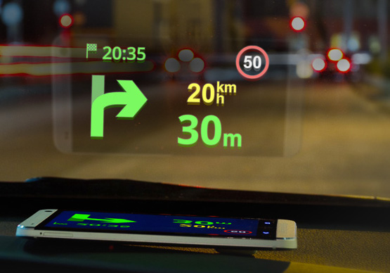
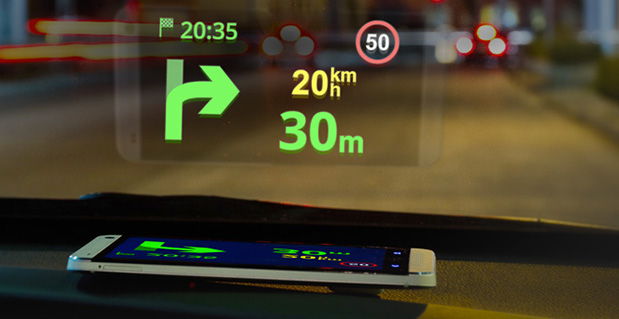
    Sygic has announced a new product to make driving safer. Sygic’s Heads-up-Display (HUD) product projects navigation information onto drivers’ windshields, so they never have to take their eyes off the road to look down at their navigation software.

    The product comes at a critical time for the holiday travel and shopping season, which is one of the most auto accident-heavy periods of the year. Sygic’s HUD is available as an in-app purchase for $4.99 and doesn’t need an expensive add-on product, as the projection can be emitted right from the Sygic GPS Navigation app on any iOS and Android phone or tablet.

    Using Sygic’s HUD interface is straightforward. Drivers activate the feature from the app’s navigation menu, flip the screen via pop-up menu, and place their phone on their dashboard. The specially optimized interface will then
    reflect clearly on the car’s windshield, displaying navigation information without the need for any expensive accessories. Sygic’s HUD feature gives them the full Sygic experience, complete with features like live traffic and turn-by-turn voice guidance.

    “As we head into the heavy travel season, we hope our HUD will help drivers stay safe on the roads so they can spend more time with their family and friends and less time driving down heavily-trafficked and dangerous winter road conditions,” said Sygic CEO Michal Štencl.

    Features of Sygic GPS Navigation include:
    •       Offline maps that don’t require a cellular data connection
    •       Turn-by-turn voice-guided GPS navigation
    •       3D cities and landscapes
    •       Voice guidance in more than 40 languages
    •       Multi-stop routes and Drag & Drop route editing
    •       Speed limit display and audio warning
    •       SOS/Help to find assistance nearby
    •       Interactive map – tap on any street, POI, or photo to choose action
    •       Robust integration with third party
    services like Groupon and TripAdvisor to find
    things like deals, restaurants, hotels, attractions and more
    •       New speed cameras feature with a
    constantly-updated database of stationary and mobile speed traps

    Unlike other map services, data in Sygic: GPS
    Navigation is stored on the user’s phone instead
    of streamed from the Internet, which means that
    Sygic users don’t have to worry about running up
    against their cellular data caps by using GPS
    navigation or getting lost in an area with poor
    cell reception. When Sygic’s users are online,
    they now have access to other helpful features
    like real-time traffic and road incident sharing with other drivers.

    Sygic GPS Navigation, now upgraded to version
    13.3, is available in the iOS App Store and
    Google Play, while the HUD feature can be
    purchased from within the app for $4.99.
    – See more at:
    http://www.gisuser.com/content/view/31596/2/#sthash.goudUtyE.dpuf

  • Galileo’s First Two FOC Satellites Endure Simulated Space Tests

    Galileo’s First Two FOC Satellites Endure Simulated Space Tests

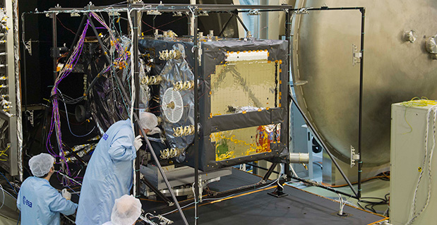
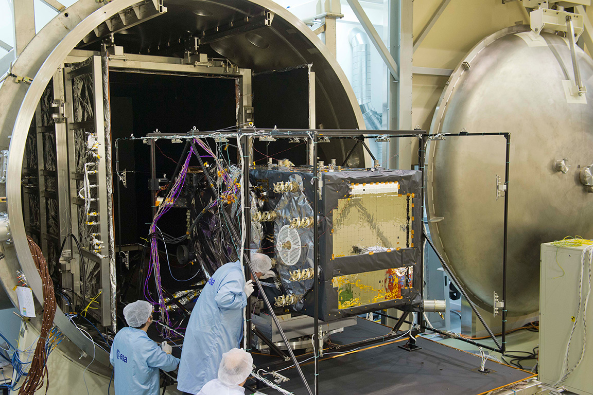
    The first Galileo Full Operational Capability satellite emerges from the Phenix test chamber after five weeks of thermal–vacuum testing.
    The first Galileo Full Operational Capability satellite emerges from the Phenix test chamber after five weeks of thermal–vacuum testing.

    ESA’s newest Galileo satellite has emerged from five weeks of simulated space conditions. On Friday, a hatch slid open to end its thermal-vacuum test, a milestone on the way to orbit.

    The satellite was placed in the 4.5-meter-diameter Phenix chamber in ESA’s ESTEC Test Centre in Noordwijk, the Netherlands, in late October. Once inside, the air was pumped out to create a space-quality vacuum. The  temperature extremes were also reproduced, with the six copper walls of the thermal tent cooled by liquid nitrogen down to -180°C.

    A second Galileo has  been undergoing the same rigors at the site, along with a vibration and shock test to reproduce separation from the launcher. Thermal-vacuum testing on the second model will begin early next year. The two satellites will be launched on a Soyuz rocket from Europe’s Spaceport in French Guiana midway through this coming year. They are the first two Full Operational Capability (FOC) satellites, following on from the first four  already in orbit.

    The next Galileo is expected to arrive at ESTEC in March, with further satellites following every seven weeks or so. A total of 22 FOC satellites are being built by OHB in Germany, with navigation payloads being delivered from Surrey Satellite Technology Ltd. in the UK.


  • u-blox Launches Precision Timing Module for Cellular Networks

    u-blox Launches Precision Timing Module for Cellular Networks

    u-blox module LEA-M8F.
    u-blox module LEA-M8F.

    Swiss-based u‑blox has unveiled the LEA-M8F precision timing GNSS module. The compact, surface-mount module generates a precise 30.72 MHz reference clock crucial for synchronizing industrial data and communication systems such as small, femto and macro-cell mobile networks. High accuracy is achieved by disciplining a local oscillator or other clock source with timing signals received from satellite-hosted atomic clocks.

    To ensure satellite availability, LEA-M8F is able to acquire and track all 50+ GPS, GLONASS and BeiDou satellites. High sensitivity enables quick autonomous start-up even inside structures with limited sky-view.

    “A reliable, compact and cost-effective precision reference clock is a crucial component used in many systems in the Critical Infrastructure and Key Resource sectors (CIKR),” said Thomas Nigg, vice president of product marketing at u-blox. “Our LEA-M8F GPS/GNSS satellite-disciplined timing module enables the proper operation of many mission-critical infrastructure systems including mobile and fixed-line communication networks, power generation and distribution systems, gas and chemical processing plants, banking, postal and goods distribution processes.”

    Measuring 17 x 22 mm, the LEA-M8F module includes a low-noise 30.72 MHz VCTCXO (voltage and temperature controlled oscillator), meeting the master reference requirements for LTE Small Cells while providing 100 parts-per-billion autonomous hold-over accuracy. The module is also suitable for TD-LTE, LTE-Advanced and other applications requiring extended hold-over times when integrated with small cell platforms.

    External sources of synchronization are supported through time-pulse and frequency inputs and a message interface. This allows measurements from macro-sniff, Sync-E or packet timing to be combined with measurements from GNSS to extend the availability of accurate synchronization and in doing so maximize cellular service availability.

    LEA-M8F can track signals from satellites from any two constellations simultaneously (e.g. GPS and GLONASS, GPS and BeiDou, GLONASS and BeiDou). Compatibility with multiple GNSS systems gives the LEA-M8F access to a large number of satellites, allowing synchronization even in urban or indoor areas with limited sky view. For stationary applications, once a location is known, accurate timing can be maintained based on the signal from just a single satellite.

    For more information, download the u-blox whitepaper “GNSS Timing and the Rise of Small Cells”. Detailed information about the LEA-M8F and evaluation kit EVK-M8F can be found on the u-blox website. Samples of the LEA-M8F will be available in Q1 2014.

    Also, the LEA-M8F will be demonstrated at the Small Cells Americas exhibition in Dallas, Dec. 3-4, at u-blox stand number 3.


  • Amazon Demonstrates Drone Delivery Service


    Amazon has unveiled its plans for a new Prime Air service that uses drone helicopters to deliver customers’ orders in as little as 30 minutes.

    Amazon CEO Jeff Bezos said in an interview on 60 Minutes on Sunday that the drones would be ready to take flight in four to five years. But an Amazon spokesperson pointed to an updated post on the company’s website promising aerial deliveries as soon as federal rules change, which could be as soon as 2015.

    In his November column, Professional OEM Editor Tony Murfin discusses the need for FAA rule changes that would allow commercial use of drones. Survey Scene Editor Eric Gakstatter also discusses the issue here.

  • Trimble Introduces ThingMagic Mercury xPRESS Platform to Simplify Integration of Embedded RFID

    Trimble announced the ThingMagic Mercury xPRESS Platform, a flexible development platform designed to simplify the process of bringing application specific RFID readers and embedded RFID solutions to market. ThingMagic_xPRESS_PlatformMercury xPRESS provides market-leading embedded RFID technology with an integrated software development environment and a range of transport interfaces and communication plug-ins in a single platform. Delivered as an extensible development environment with reference design files, the platform also reduces the need for developers to have significant RFID domain expertise, facilitating the rapid integration of RFID with a variety of products and complementary wireless communication technologies.

    “Simplifying the incorporation of RFID into existing and new solutions is important to the ongoing growth of our industry,” said Tom Grant, general manager of Trimble’s ThingMagic Division. “Our goal with the Mercury xPRESS Platform is to allow our customers to incorporate RFID into their applications and solutions in a timely and cost effective way. The value of RFID is becoming clearer; we need to complement that growing interest with a set of tools that make its application straight forward. That’s exactly what the Mercury xPRESS Platform provides.”

    Leveraging over 10 years of RFID technology advancements and development expertise, the Mercury xPRESS Platform combines a microcontroller-based motherboard with the industry-leading ThingMagic Mercury6e Series of RFID modules and an integrated software development environment built on the ThingMagic Mercury C API. With the platform, developers can bring up a fully functional RFID reader in minutes; testing and proof of concept using sample applications from the software library can start almost immediately. Reference design files allow developers to select the elements needed for their solution and advance rapidly to application specific end product design and development. The Mercury xPRESS Platform has been screened for regulatory compliance, reducing cost and time to secure end product certifications.

    Key components of the Mercury xPRESS Platform are:

    -Hardware kit with microcontroller-based motherboard, including:

    • Integrated ThingMagic UHF RFID module (Micro, Micro-LTE, or M6e)
    • USB interface
    • Ports for up to 2 additional plug-in data transport interface modules

    -MCU preloaded with sample keyboard wedge application
    -An optional Bluetooth plug-in module (sold separately)
    -Software toolkit and SDK (downloadable)
    -Reference design files including schematics, layout files, Gerber files, bill of material, component data sheets (downloadable)

    “ThingMagic is a valued technology partner of MEPS Real-Time. The introduction of the ThingMagic Mercury xPRESS Platform provides our Engineering and Marketing departments with the opportunity to offer new and innovative solutions through our Intelliguard product line,” said Shariq Hussain, president and CEO, MEPS Real-Time, Inc. “We see growth in the healthcare industry that will require smaller, faster and more capable RFID technology. With the Mercury xPRESS Platform, combined with our intellectual property, we are positioned to bring solutions to our customers that deliver world class performance and capabilities.”

    The Mercury xPRESS Platform represents an alternative to using expensive general purpose readers in RFID solution designs. Lack of time, skills or resources to develop application specific readers can be much less of a barrier, resulting in unit cost savings, deployments with a stronger ROI and an overall positive bottom line impact in many deployments.

    To support ongoing innovation, the integrated development tools, device drivers and application software of the Mercury xPRESS Platform may be enhanced with updates that expand capabilities and enable development of a wider range of end products. In this release, the xPRESS Platform supports USB and Bluetooth transport interface applications. Support for Wi-Fi, POE and other interfaces such as GPRS, GPS, 4G/LTE may be included in future releases at Trimble�s discretion. Mercury xPRESS is also designed to support a library of sample applications. A native keyboard wedge is available today while other sample applications may be included in future releases.

  • SuperSurv for iOS V0.99 Now Available on App Store

    Supergeo announced that SuperSurv for iOS V0.99 is now available on the App Store for trial. SuperSurv

    According to the announcement, SuperSurv, the mobile GIS application designed for field survey, integrates with GIS and GPS technologies to provide functions like Map Display, Query, Measure, etc, and supports point, line and polygon data collection and offline data editing. In addition to the Android edition, SuperSurv is now available for iOS users to collect spatial data.

    SuperSurv for iOS V0.99 trial is now available on the App Store. OpenStreetMap can be employed as the basemap in SuperSurv to help filed surveyors collect point, line and polygon feature and the attribute data. The collected data can be saved in vector layers (SHP format) and exported through iTunes to be applied in various GIS programs.

    SuperSurv for iOS full version will contain the functions, like Waypoint, GPS Track, Measure Function, Query, and reading and editing the services published by SuperGIS Server 3.1a. The full function is planned to be launched in the beginning of 2014. To learn more about SuperSurv for iOS, please download the trial on App Store.

  • SuperSurv for iOS V0.99 Now Available on App Store

    Supergeo announced that SuperSurv for iOS V0.99 is now available on the App Store for trial. SuperSurv

    According to the announcement, SuperSurv, the mobile GIS application designed for field survey, integrates with GIS and GPS technologies to provide functions like Map Display, Query, Measure, etc, and supports point, line and polygon data collection and offline data editing. In addition to the Android edition, SuperSurv is now available for iOS users to collect spatial data.

    SuperSurv for iOS V0.99 trial is now available on the App Store. OpenStreetMap can be employed as the basemap in SuperSurv to help filed surveyors collect point, line and polygon feature and the attribute data. The collected data can be saved in vector layers (SHP format) and exported through iTunes to be applied in various GIS programs.

    SuperSurv for iOS full version will contain the functions, like Waypoint, GPS Track, Measure Function, Query, and reading and editing the services published by SuperGIS Server 3.1a. The full function is planned to be launched in the beginning of 2014. To learn more about SuperSurv for iOS, please download the trial on App Store.

  • The Business — December 2013

    The Business section and the Product Showcase from the December 2013 issue (Download the PDF).

    Includes: NovAtel Launches CORRECT OEM Positioning; Applanix Airborne Mapping Products Given Trimble CenterPoint Service; Volvo, Mercedes-Benz Drive Roll out of ADAS as Standard Equipment in Cars; Kinexon Named Galileo Master for Athlete Tracking Analysis; Altus Launches Juniper Archer 2; and more.