A vector model displayed in orthographic projection.
Arithmetica will be demonstrating Pointfuse at Intergeo, which is being held this week in Essen, Germany.
Pointfuse is a powerful modeling engine that has been created to give professionals a fast, precise and flexible way of turning vast point cloud data sets (whether derived from LIDAR or photogrammetry) into high-fidelity vector models, the company said.
Replacing painstaking and costly manual modeling, Pointfuse uses advanced techniques at the interface of mathematical optimization and computational statistics to automatically and rapidly convert point clouds into accurate vector models that can then be manipulated using any industry-standard CAD system.
Pointfuse is fully mobile compatible, and can process data from mobile scanners as easily and quickly as from terrestrial or airborne systems. Results can be output and used on standard handheld mobile devices, making it useful for creating and viewing highly detailed models in the field.
A point cloud image of a motorway with crash barriers extracted and highlighted by Pointfuse. Data courtesy of Blom Aerofilms Ltd.
The software will also fully automate extraction of features from point cloud data, allowing the intelligent recognition, measurement and cataloguing of objects and built environments, and other forms of extracted knowledge.
George Skrobanski, chief technical officer of Arithmetica, explains the significance of this development. “Achieving the automatic extraction of features from point cloud data has been the Holy Grail for the industry. Pointfuse uses its proprietary technology to provide true automation and we believe this changes the game.”
At Intergeo, learn more at Arithmetica’s booth (Hall: 3 – Booth: D3.046).
Orbit GeoSpatial Technologies will be presenting the Clearance Checker for Mobile Mapping at this year’s Intergeo, being held this week in Essen, Germany.
“The Clearance Checker is an automatic detection tool that uses any mobile mapping lidar data to check clearances in height and width over any designated trajectory,” said Peter Bonne, vice president of business development and senior product manager at Orbit GT. “With the Clearance Checker, a vehicle contour of any designed size, is virtually driven through the point cloud over a chosen trajectory. Any collision or near-collision is automatically detected and listed for reporting, interpretation and subsequent actions. This tool is a must have for all rail- or tramway exploitation, oversize transport planning, and indeed every road and railroad maintenance or improvement project. This tool is an add-on to the Mobile Mapping Asset Inventory solution and is the first in a range of automated and semi-automated detection tools to be made available in shortly.”
Disy Informationssysteme GmbH will present GIS 2go at Intergeo 2013, being held this week in Essen, Germany. GIS 2go transfers maps from ArcGIS Desktop to an iPad or Android tablet. With the associated app, users can access their own maps without a network connection while they are on the road.
Intergeo is the world’s largest conference and trade fair for geodesy, geoinformation and land management. From October 8-10, visitors to stand D1.045 in hall 1 can experience GIS 2go live and meet with experts and developers in person.
GIS 2go allows maps to be taken along with the user, from Esri’s ArcGIS Desktop to a tablet (iPad or Android). With the GIS 2go Add-in, the data selection, the map export and the re-import are controlled via the cloud in ArcGIS Desktop. On the tablet, the “Cadenza Mobile GIS 2go App” allows access to the maps with all feature data — be it with or without a network connection. Even graphic notes and media created on the go are taken over into ArcGIS Desktop.
On the tablet, users can move interactively on the map; display feature attributes; add points, lines and areas with the graphic notebook; or track via GPS; augment the map with photos and audio/video clips or simply use text to comment on it. The information recorded remotely will be imported later into ArcGIS Desktop and taken over into the data storage.
In step with the path of the latest technologies in three dimensional laser scanning and photogrammetry, Gexcel Srl has released the new version of JRC 3D Reconstructor 2.9.1 with a special focus on UAV and drone platforms.
Gexcel Srl is attending Intergeo, taking place this week in Essen, Germany. Gexcel is using the event to introduce new 3D software tools and solutions focusing on the most recent release of the JRC 3D Reconstructor software for Unmanned Aerial Vehicle (UAV) and drone platforms.
UAVs and drones can quickly and cheaply capture georeferenced high-resolution images, Gexcel said. Third-party software typically produces GeoTIFF global images and 3D point clouds of the investigated area. These ingredients can be easily managed in JRC 3D Reconstructor to merge the GeoTIFF global image color over the point cloud and produce a 3D HR texturized point cloud and 3D HR texturized mesh models, Gexcel said.
Using JRC 3D Reconstructor, all the volume calculations, cross sections, cut and fill, crests and toes, and isolines can be created with a greater accuracy, because of real color state processing. This new feature emphasizes the importance that JRC 3D Reconstructor gives to the color information. It is considered as a most powerful tool for detailed geotechnical and geological investigations.
Gexcel Srl also announced the launch of its new Point Cloud Streaming Service based on a web application. The service allows to upload point clouds generated using Gexcel R3 or the new Gexcel R3 streaming software to a remote server. Gexcel R3 can import data directly from the most common point cloud data formats, E57 included. Massive point clouds loaded in the service servers can be visualized and navigated in Chrome or Firefox using a standard 64-bit PC.
The service is designed to improve the ability of users to visualize the results of 3D laser scanning surveys with collaborators, clients and web community. The 3D point clouds can be also customized to include proprietary company logos and project banners.
Using an airborne mapping system, aerial surveying company Bluesky is expanding its international operations. The integrated system, developed by Optech, includes a LiDAR and fully integrated thermal sensor and high-resolution camera.
Bluesky is exhibiting at Intergeo 2013, being held this week in Essen, Germany.
Already proven in the UK the system, thought to be a world first, has already been successfully deployed in Northern Europe with additional projects proposed in Central Europe and the Middle East. The Bluesky system combines the Orion M300 LiDAR, CS-LW640 Long Wave Infrared thermal sensor and a CS-10000 RGB camera.
“The integrated Optech system has been very successfully used for many projects in the UK and the results have provided our customers with the highest quality data as well as economic advantages due to the simultaneous capture of multiple data types,” commented Rachel Tidmarsh, Managing Director of Bluesky International. “We are now in a position to offer these advantages to potential customers around the world.”
“Bluesky is the perfect example of an organization with the talent and vision to take full advantage of the unique capabilities of the latest Optech sensors. In addition, we are pleased that the ultra-compact and modular design of the system has made it portable and easy to install for them, further supporting Bluesky in their ambitious plans to expand their operations beyond the UK,” added Bill Sharp, Marketing Manager at Optech, Inc.
The Optech solution used by Bluesky includes an Orion M300 LiDAR (Light Imaging Detection and Ranging) system; which uses aircraft mounted lasers to accurately determine the distance between the sensor and the ground or other targets such as buildings and vegetation. Specifically designed to offer a cost effective, high performance solution at mid altitudes, the Orion M300 is ideally suited for applications such as infrastructure modelling and environmental monitoring, including flood risk analysis and forestry management.
The Optech CS-LW640 sensor records thermal infrared measurements and has already generated impressive results for recent projects. In upcoming projects it will be used for identifying heat loss from buildings, pipeline monitoring and forestry analysis. Like the CS-10000, it can be used simultaneously with the LiDAR or independently to fit the end user requirements. In addition to capturing thermal images of the target sites, the CS-LW640 camera can be mounted simultaneously with the other two sensors, providing customers with a wealth of coincident information for their area of interest; a complete solution, including highly efficient automated data processing, resulting in substantial acquisition savings.
Spireon, a Mobile Resource Management (MRM) and Business Intelligence Solutions provider, has completed an initial phase of the integration of its industry leading GoldStar GPS solution with Frazer’s Dealer Management System (DMS).
Frazer is a provider of software solutions that auto dealers across the nation use to grow their business and increase their productivity, including its comprehensive DMS, which has functions such as dealer inventory management, credit application processing, electronic contracting, set up bank contracts and BHPH deals, dealer management tools, loan servicing and accounting systems.
Joint customers of GoldStar GPS and Frazer can now experience online access to a single solution to execute critical commands. The integration allows dealers to execute commands directly from their Frazer application, interface saving customers time and improving their ease of use. Dealers can monitor and take action on their collateral within their day-to-day dealer management application. Key features of the initial phase of integration include the ability to conduct an on-demand locate, and disable and re-enable the starter interrupt.
“Spireon’s new partnership with Frazer is another example of Spireon’s ongoing quest to improve the ease of use of our solutions through key partnerships to enhance the customer experience for effective collateral management, vehicle tracking and risk mitigation. GoldStar GPS and Frazer users will experience a platform that will allow them to do more.” Explains David Meyer, Executive Vice President of Spireon.
“We have watched the incredible growth of GoldStar GPS and are very excited about now offering Goldstar GPS as an integrated feature within the Frazer DMS. This will make a lot of dealers’ lives just a little bit easier.” Michael Frazer, President.
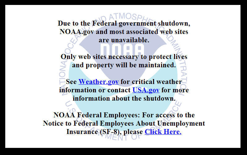
On October 1, the U.S. federal government shut down and furloughed 800,000 non-essential workers. While services considered essential remained active, those considered non-essential services, like the National Geodetic Survey’s Online Positioning User Service (OPUS), were shut down. OPUS is a free, online GPS post-processing service. If you try to access www.ngs.noaa.gov, the following screen will be displayed:
For those of you who rely on OPUS for GPS post-processing, now is a great time to try one of the other seven online post-processing services available and not subject to the U.S. federal government. Yes! I wrote seven, and the results from those seven are comparable to OPUS. The other seven, free online GPS post-processing services are:
CSRS-PPP: Canadian Spatial Reference System, Natural Resources Canada
My colleague Mark Silver, creator of the X90-OPUS receiver I wrote about a few months ago, embarked on an effort to run test data through each of the online post-processing services to demonstrate that there are free, online GPS post-processing services available worldwide that produce results comparable to OPUS. The following report is the result of his efforts:
A Comparison of Free GPS Online Post-Processing Services
By Mark Silver
You are probably familiar with the National Geodetic Survey’s OPUS suite of online post processing tools (OPUS-Static, OPUS-Rapid Static and OPUS-Projects.) These services are capable of producing centimeter-level positioning from static GPS observations. What you may not realize is there are at least six viable alternatives to OPUS.
All are free, easy to use, provide world-wide coverage, and generate surprisingly similar results.
Since each uses a unique baseline tool and processing strategies they form an excellent reality check against each other.
IGS orbits and the IGS permanent CORS arrays are used by many of the services, however some use proprietary equipment arrays and orbit products that provide additional redundancy.
How comparable are these services? Which one is the best?
Criteria for Comparing
Comparing results is a difficult proposition:
The true/correct answer for any site is unknown.
What grading scale should be used? Should elevation differences be weighted differently than horizontal differences?
Should the peak-to-peak range or the standard-deviation be prized?
Should comparisons be made on long 24-hour data sets or short 2-hour occupations?
Is a single data set sufficient for a meaningful comparison or are multiple data sets preferable?
Should a service be ‘thrown out’ of consideration because the solutions are substantially different from the mean?
The answer to all of these questions is “it depends.” Your evaluation will depend on your specific application.
For this evaluation, the following rules governed the data set selection:
Choose a site known to be stable with a clean EMI environment.
Use 24-hour observation sets to enable ‘best case’ processing.
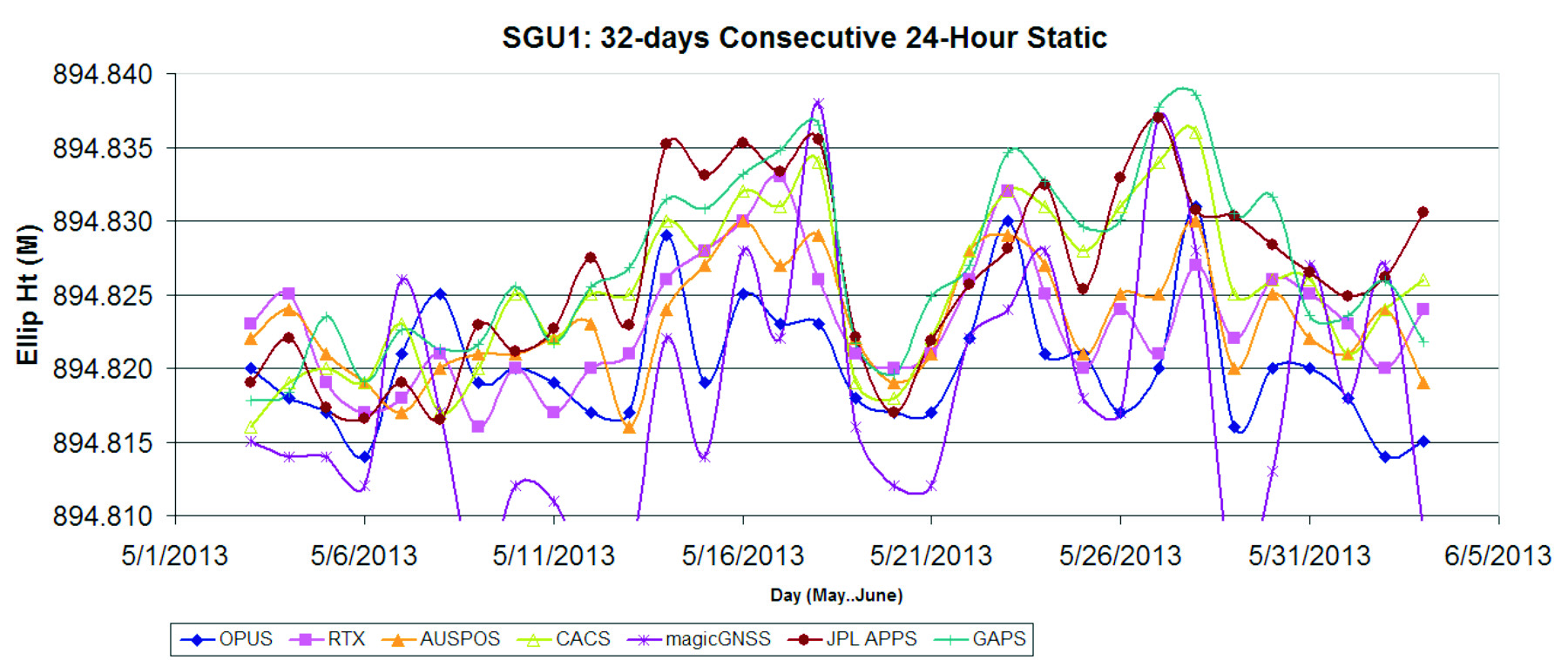
Use a sufficiently large data set, 32-consecutive days, to expose trends.
Choose a time period, 90-days in the past, so precise orbits are available to reduce ephemeris effects.
Only consider GPS data.
Use default settings for every option on each processing service.
Scoring
This would not be as interesting without a little competition.
To keep the evaluation simple, the sum of the X, Y and Height range will be the score and the services will be ranked from lowest score to highest score, with the low score being the ‘best.’
Range was chosen as an indicator of the expected maximum error that might be encountered if only a single 24-hour file was observed.
The combined range rewards a processing scheme that best estimates delays, interference, clock errors and other sources of change that occurred during the 32-day trial.
Remember that the every aspect of this ‘competition’ is arbitrary: from the selection of observation sets, to the final scoring system.
The real take-away from this evaluation is not that one service is better, but how close all of the services are to each other.
Two services (JPS’s APPS, magicGNSS) won’t be acceptable to the average user and a third (RTX Centerpoint) may not work for some users based on receiver and antenna support. Details of these problems are presented with the service descriptions below.
The Test Data
SGU1 in St. George, UT USA was chosen as the observation base. The observations consist of 32 consecutive days (May 3, 2013 through June 3, 2013), 24-hour observation files, 30-second interval, GPS only data. The data files were downloaded from the NGS CORS archive.
Each of the 32 files were submitted to each of the processing services and the results have been tabulated for X, Y and Ellipsoid Height. All data is presented in IGS08 current epoch framed coordinates. All data has been projected to UTM Meters for these comparisons.
The Average Values
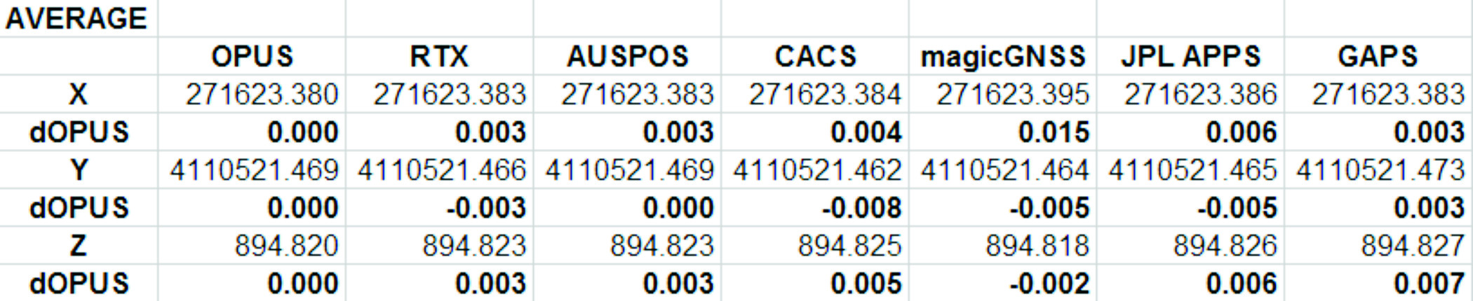
Remember, the real story is how close each of these services produce results to one another. Let’s look at the average positions from each service and the difference from OPUS:
Fig 1: Average Solution Difference from OPUS
As you can see in Figure 1 above, the services were generally within 5mm of OPUS in X, Y and Height.
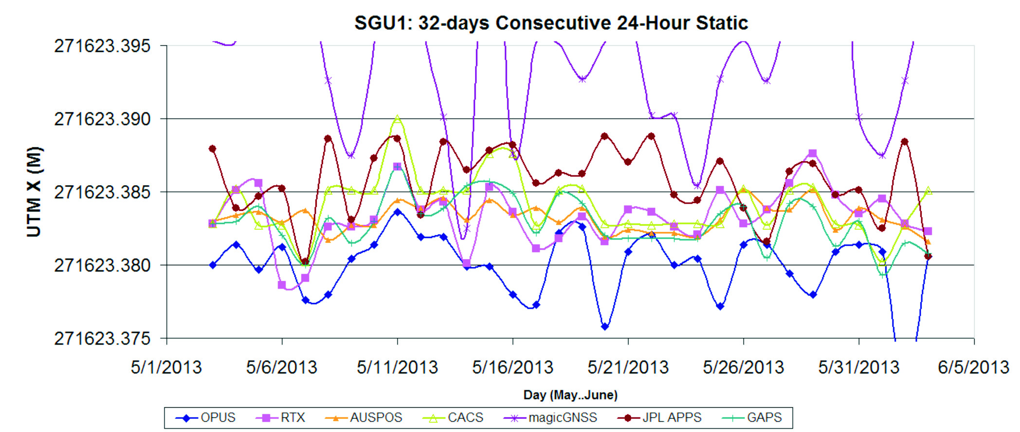
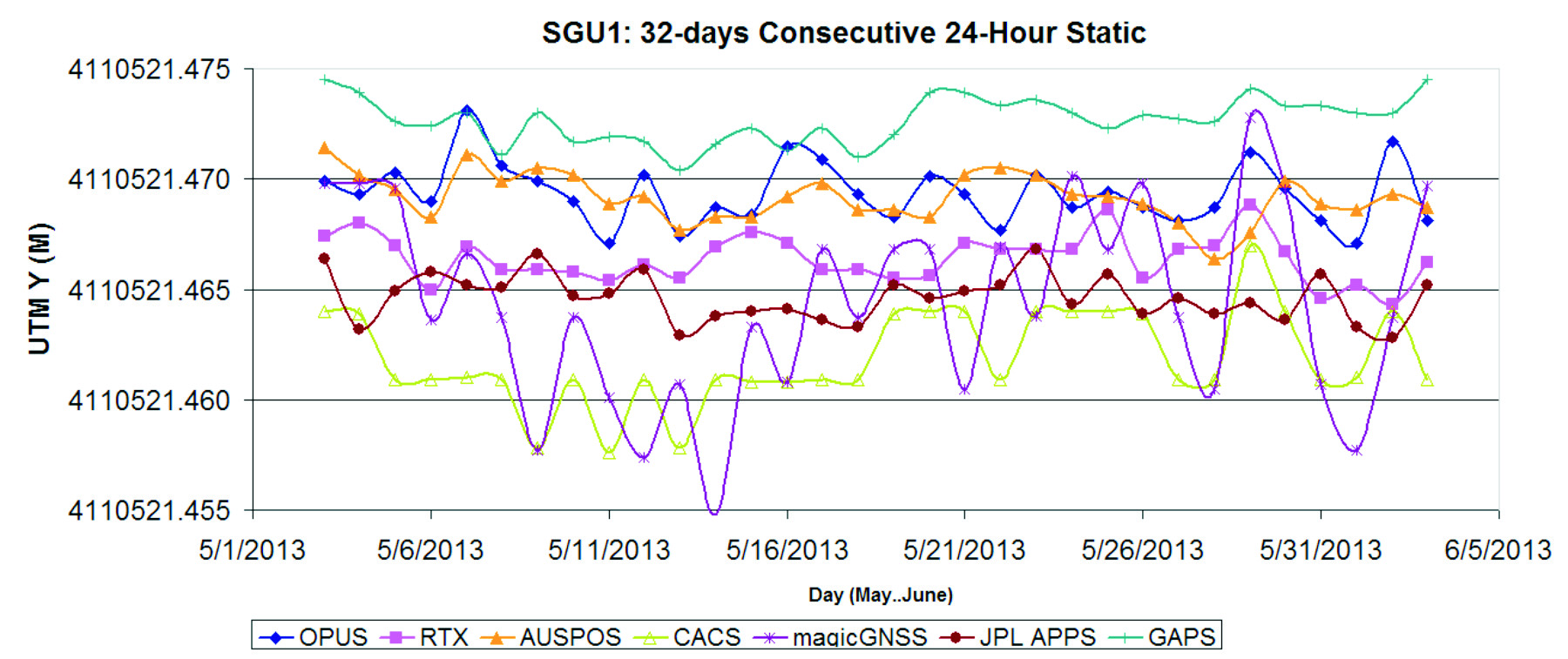
Position Tracking vs. Time
Fig 2: Service Results X vs. Time
Fig 3: Service Results X Range, Average
Fig 4: Service Results vs. Time
Fig 5: Service Results Y Range, Average
Fig 6: Service Results Z vs. Time
Fig 7: Service Results Z vs. Time
And the Winner Is…
Following are the scores, based on the combination of X, Y and Height range:
Fig 8: The Scores
Score ranking (remember this is just for fun as the services provided remarkably similar results):
AUSPOS
CenterPointRTX
GAPS
APPS
OPUS
CSRS-PPP
magicGNSS
There is a significant issue in the JPL APPS’s reported output positions, which will keep it from being of any use to most users. magicGNSS’s results are significantly different than the other services. User’s should independently evaluate magicGNSS’s suitability for their purpose. SOPAC’s SCOUT could not be evaluated because it patently does not support either the receiver or antenna that was used at the test site.
AUSPOS is a free service from Geoscience Australia. Access is via a simple web interface, the antenna height and type are entered along with a email address for the returned report set. File submission is via FTP or directly from the web interface.
The returned PDF report is the best looking of the reviewed services and includes a Processing Summary showing a map of the CORS sites that were used in the solution. SINEX files are also available.
AUSPOS uses the Bernese GNSS Software for processing baselines, IGS orbits and IGS network stations. Solutions are available for anywhere on the earth.
RINEX files need to be at least 1-hour in length, 6-hour files are recommended. Compact RINEX files are also accepted. Files may be compressed with UNIX, Hatanaka, ZIP, gzip or bzip compression.
Centerpoint RTX Post Processing: Trimble Navigation Limited
CenterPoint RTX Post Processing is a free service offered by Trimble.
It works anywhere in the world and is based on a proprietary Trimble 100+ worldwide CORS network. Accuracy is 2 cm with 1-hour of observation data; 1 cm with 24-hours. Files longer than 24-hours are not accepted.
RTX uses GPS, GLONASS and QZSS tracked SV’s.
The reported output frames include ITRF2008 at current epoch and a user selectable frame like NAD83/2011 2010.0. RTX is one of the few services that will directly export NAD83 framed results.
A single page PDF and a XML result file are returned by RTX. Unfortunately, it is not possible to copy numerical results from the read-only PDF result file to the clipboard.
RTX supports a limited number of receivers (Trimble) and a relatively small subset of IGS modeled antennas. For this test, TEQC was used to stuff the RINEX headers with a comparable Trimble receiver to the actual Ashtech ProFlex 500 receiver that is in use at SGU1. This was all that was required to spoof an accepted device. If the antenna had not been listed, it would have been necessary to spoof the antenna and adjust the height to reflect the difference in L1 phase center offset.
GAPS is an ongoing project at the University of New Brunswick and was developed by the Department of Geodesy and Geomatics Engineering.
File submission is by a web page and GAPS provides a large number of user inputs and potentially allows the highest level of customization of any of the reviewed services:
You may enter a priori coordinates, and a priori constraints
GAPS accepts static or kinematic files
You can set the elevation mask
The Neutral Atmosphere Delay model is selectable
Earth Body Tides and Ocean Tidal Loading can be applied or disabled
GAPS only processes GPS data (no GLONASS.)
Submitted filenames must adhere to the SSSSDDDh.YYt file format. GAPS accepts RINEX and compact RINEX files, they may optionally be gzip, unix compressed or ZIP compressed.
WARNING! APPS only reports the derived position to the nearest decimeter-meter in geographic (lat/lon) coordinates, while reporting ECEF coordinates to a fraction of a millimeter. If you choose to use APPS, you will need to manually convert the ECEF XYZ to geographic coordinates.
JPL’s APPS is based on GIPSY-OASIS (currently version 5). APPS uses NASA’s 70+ Global GPS Network plus densification from other systems (100+ total receivers distributed globally.) Solutions are typically available with 5 seconds delay from observation.
APPS is easy to use, you just specify a file to upload and then click on ‘Upload’ it takes only 15 seconds to get a result after the file upload is complete. You can optionally register for a free account and use email or FTP for bulk uploads.
APPS also has receiver Live Performance Monitoring: (http://www.gdgps.net/monitoring/index.html) which generates a real time graph of three receivers spread through the world.
Before using CSRS-PPP, you will need to register for a free user account.
CSRS has a fantastic desktop application named PPP-Direct that you can just drag and drop files onto. PPP-Direct automatically submits the file and saves all typing, greatly reducing the chance of error.
CSRS-PPP uses both GPS and GLONASS (if available) observables. Ocean Title Loading corrections can be overridden.
CSRS-PPP will accept single frequency files for processing. CSRS will accept RINEX and Compact RINEX, and will decode ZIP, GZIP and unix compression formats.
CSRS-PPP has a fantastic PDF report, a .csv file detailing results epoch by epoch and a great machine readable summary file.
The desktop submission tool, coupled with the great output reports made CSRS-PPP my favorite tool.
magicGNSS accepts emailed files and returns solutions by email. Turnaround time is fast and features a nice PDF report plus SINEX, receiver clock bias files, tropospheric delay, KML trajectory and RINEX CLK clock bias files.
Static and kinematic files with observations from GPS, GLONASS are processed by magicGNSS and the service reportedly Galileo-ready.
magicGNSS uses a subset of IGS stations to provide core coverage.
SCOUT: Scripps Orbit and Permanent Array Center (SOPAC). University of California, San Diego
Scout accepts RINEX and compact RINEX files, compressed (Z, gz, ZIP) submitted from an FTP site or pushed onto a provided FTP server.
Files must be generated on a limited subset of receivers and antennas. While the IGS antenna and receiver files are the basis for acceptable devices, not all IGS-listed devices are on the allowable device list. SCOUT documentation specifically warns against spoofing devices and antennas.
SCOUT uses the GAMIT processing engine.
Because the test data for this article is from a unsupported receiver and the submittal process requires a FTP host server with anonymous access which most users will not bother with, the output from SCOUT was not evaluated.
Conclusion
The similarity of results between all of the services I processed is amazing. That they differ only by millimeters demonstrates the robustness of the algorithms and processes they use.
The difference between AUSPOS, RTX, GAPS, OPUS and CSRS-PPP solutions are negligible. For important positioning projects, it undoubtedly makes sense to use them all.
For locations in the United States, OPUS and RTX return NAD83-2011 framed results. Only OPUS returns derived orthometric heights using GEOID12A. While OPUS has more provenance than the other services, it is easy enough to submit important observations to multiple services as a reality check for important positions.
###
As you read from Mark’s report above, even though OPUS is shut down until the U.S. Congress can resolve its differences, don’t let that stop you from processing your GPS static sessions. However, some level of due diligence on your part is needed as requirements vary for each service. For example, static sessions for the OPUS-RS service can be as short as 15 minutes while other services require two hour GPS static sessions. Furthermore, some services process GPS L1 data while others require both GPS L1 and GPS L2 observations.
Spirent now offers A-GNSS record and playback capabilities for mobile device testing.
Spirent Communications today announced the availability of carrier-approved Assisted GNSS Record and Playback capabilities on its Hybrid Location Technology Solution (HLTS). This new A-GNSS Record and Playback capability provides unprecedented realism and repeatability by recording GNSS signals in the field and delivering synchronized assistance data over a radio access interface to test the A-GNSS positioning performance of mobile devices in the lab.
“With user location playing a key role in most smartphone services and applications, A-GNSS positioning performance greatly influences the end-user experience,” said Nigel Wright, vice president of wireless, Spirent Communications. “This new A-GNSS Record and Playback solution enables device manufacturers and network operators, as well as chipset and technology vendors, to accurately test this essential technology using real-world field conditions. This helps ensure high quality LBS and emergency service performance for every mobile subscriber.”
Combining GNSS signals from multiple satellite positioning systems (such as GPS and GLONASS) with assistance data delivered by the network to the device, A-GNSS is regarded as the most universal and precise positioning technology. As such, it is used in mobile devices to support the location information required by commercial services, social media and emergency services such as E911.
Although established A-GNSS simulation tools play an important role in generating repeatable and reliable controlled environments in the lab, they can have limitations when it comes to representing the full range of challenging conditions experienced by mobile users on live networks. Spirent’s A-GNSS Record and Playback addresses these limitations by capturing conditions in the field and playing them back in a reliable and repeatable lab environment. This helps to reduce device time to market and control testing cost by reducing the need for extensive field testing.
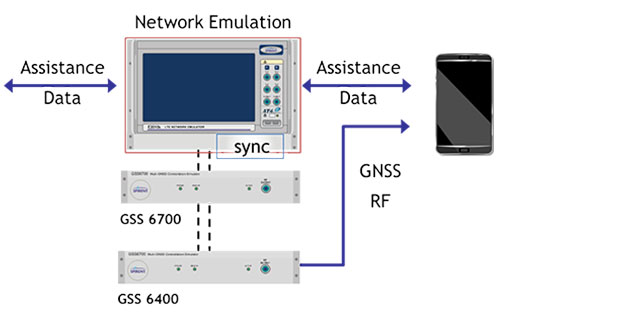
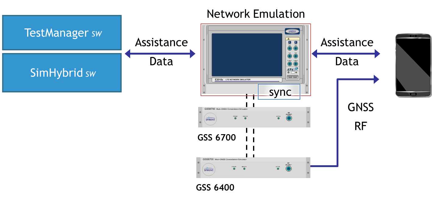
Spirent HLTS is recognized by the industry for its unique capabilities that span a wide range of test requirements from early R&D phases to mobile device acceptance. The HLTS now incorporates Spirent’s GSS6400 GNSS Record and Playback System (RPS), together with patent-pending SimHybrid software that generates and delivers the correct assistance data, synchronized with the recorded GNSS signals.
Orbit Logic announced that their SpyMeSat iPhone app is now available on the Apple App Store. The SpyMeSat app provides notifications when imaging satellites are overhead and may be taking your picture. A dynamic map shows orbit tracks and the location of satellites with upcoming passes over the user-specified location.
SpyMeSat iPhone App
According to the announcement, this is Orbit Logic’s first app targeted for consumers outside their standard customer base in the aerospace, defense, and government intelligence communities.
“This app is for everyone.” said Alex Herz, president of Orbit Logic. “Whenever I talk to people outside the aerospace industry about what I do they have so many questions. I realized there was a place for an app to provide information, education and awareness about imaging satellites to a wider audience. And it’s fun for aerospace industry insiders too!”
The SpyMeSat app uses NORAD orbit data published online by www.celestrak.com and available public information about commercial and international imaging satellites to compute and dynamically display satellite overflights and imaging pass information. The app user can drill down to see additional details about each imaging opportunity, and the app provides a page describing each satellite for those who want to learn more.
SpyMeSat users can configure the app to enable or disable individual satellites, change the location of interest, enable or disable various notification options, and specify the resolution limit for computed passes. Orbit Logic can create custom SpyMeSat solutions for any constellation of satellites. With a custom SpyMeSat solution, authorized users can make satellite tasking requests directly from the mobile device.
This colloquium intends to bring together leading members of the European scientific community and their international partners. One of its aims is to propose those in charge of Galileo operations and development means of enhancing the scientific use of Galileo and to contribute to GNSS development based on scientific approaches.
The colloquium will address four major areas of research:
Scientific applications in meteorology, geodesy, geophysics, space physics, oceanography, land surface and ecosystem studies, using either direct or reflected signals, differential measurements, phase measurements, radio occultation measurements, using receivers placed on the ground, in airplanes or on satellites.
Scientific developments in physics, dealing with future GNSS, particularly in testing fundamental laws in astronomy and in quantum communication. Relativistic reference frames and relativistic positioning will be addressed.
Aspects of metrology, such as reference frames, on board and ground clocks as well as precise orbit determination
Scientific aspects of satellite navigation and positioning such as signal propagation, tropospheric and ionospheric corrections and means to model and mitigate multipath and interference
During this colloquium, the various possibilities to use navigation satellites such as Galileo satellites for scientific purposes shall be reviewed and the question be answered how these scientific applications can contribute to make the most of the present systems, and define their future evolution. The conference will be organized as a series of plenary talks and two parallel half-day sessions.
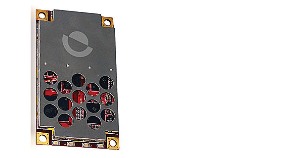
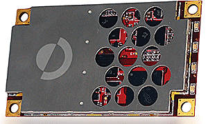
Today, Hemisphere GNSS introduces the Eclipse P306 and P307, the latest models in the Eclipse series. The Eclipse P306 and P307 track multi-frequency GPS, GLONASS, and BeiDou satellite signals and are Galileo and QZSS ready. By tracking more signals, RTK positioning performance improves especially in challenging environments.
The Eclipse P306 and P307 are the first products to utilize the company’s new SX4 ASIC. Capable of simultaneously tracking code and phase signals on 89 satellites, SX4 boasts 372 channels and can be configured to address several diverse applications through software.
Smaller than a business card, the Eclipse P306 upgrades existing designs using Hemisphere’s standard 34-pin modules. The Eclipse P307 is a drop-in upgrade for designs based on the industry accepted 20-pin module. Both products offer scalable performance. RTK accuracy is achieved in either single- or dual-frequency mode. When subscribed for multi-frequency, multi-constellation RTK, Eclipse receivers have fast RTK initialization times even over long distances.
“While the Eclipse P306 and P307 provide outstanding RTK performance,” commented Dr. Mike Whitehead, Chief Technology Officer of Hemisphere GNSS, “non-RTK users benefit from our COAST, SureTrack, and HeadStart technologies.” COAST and SureTrack work together to maintain sub-meter positioning for 40 minutes when differential corrections are lost. HeadStart reduces the occurrence of cold starts by keeping time while the receiver module is powered off, providing faster startup times.
Support of the Chinese BeiDou GNSS constellation is significant. The BeiDou constellation not only fully covers China, but extends beyond, covering 2/3 of the world’s land mass, benefiting 5.8 billion people. Coverage currently includes Asia, Australia, New Zealand to South Africa, Europe and all of Russia, as well as Hawaii with, on average, three or more BeiDou satellites visible above 15°.
In February 2013, Hemisphere GPS changed its name to Hemisphere GNSS, Inc., after parting ways with its agriculture unit. While both names are owned by the company, in order to reflect the company’s support of all GNSSs and update the company’s image, “Hemisphere” has been adopted as its brand name. The company also has adopted a new logo and has launched an updated website, www.HemisphereGNSS.com.
Hemisphere will be introducing the new Eclipse P306 and P307 OEM positioning modules at the annual Intergeo conference in Essen, Germany, October 8th-10th, 2013 at Booth #A3.070.
Last week I attended the ION GNSS+ Conference (Institute of Navigation / Global Navigation Satellite Systems) in Nashville, touted as the largest GNSS conference in the world. Although Geospatial Solutions is closely aligned with GPS World, my focus is on GIS, and like most GIS people, we look at GPS devices as data collection tools and most of us don’t get heavily involved with the workings of the equipment or GPS community.
Since I only live two hours away from Nashville, my editor, Alan Cameron, invited me to attend so I could meet the GPS World staff and peek over the wall into the GPS community. It was time well spent, since I was exposed to the ongoing evolution and problems being addressed by the GPS community, which seems to have a higher percentage of Ph.D.s than any other conference I’ve attended. There was a lot of hardware and software outside my realm of experience, so some of my observations may be simplistic or old news to some of you. Please bear with me as I share topics that I believe may be of interest to the GIS community.
For starters, GPS is just a modern tool to do global navigation, not much different from when I was doing celestial navigation on a Navy destroyer in the ’70s and ’80s. The concept is fairly simple, although the execution is not.
Every star in the sky is fixed in space with an observer on earth either at the nadir point where the star is directly overhead at 90 degrees or most likely somewhere between 90 degrees and the horizon, 0 degrees. A sextant is used to measure that angle, and all possible points at that angle describe a unique circle on the Earth where that measurement can exist. Intersection of two other star circles can then locate a unique point on the earth. This sounds simple in theory, but the actual process is not, since the Earth is constantly rotating, wobbling and moving through its annual orbit. Additionally, cloud cover can obscure the stars, and rough weather can make precision observations all but impossible. Then, after shooting the stars, over an hour of work was required looking up data in celestial tables and doing tedious computations to get each line of position.
British Atmospheric Data Centre (BADC).
Early electronic navigation systems such as Omega and Loran C helped made some navigation a bit easier. They used time delay and phase shifting between radio transmitters to create hyperbolic lines of position between two transmitters. Three transmitters produced two sets of lines, and the intersection was your position. Both celestial and early electronic navigation were not very accurate and not particularly easy to use. Both were phased out in favor of GPS, which sort of combines the concept of celestial with electronic navigation.
GPS even uses the term a “constellation” of satellites. The satellites provide very exact position information to GPS receivers, which calculate the observer’s position similar to celestial fix. Additionally, accurate and precisely measured time is so important that scientists actually take into account the theory of relativity and dilation of time caused by the very fast travel of GPS satellites to have system accuracy that is adequate.
New Players
GPS was developed in the ’60s and ’70s by the U.S. military, but opened to civil use by Ronald Reagan after the shooting down of KAL flight 007 by the Soviet Union. They thought the 747 was spying, but in reality the inaccurate navigation systems erroneously put the civilian airliner into Soviet airspace. In the late ’90s, the U.S. Navy moved to GPS and away from traditional celestial and land-based electronic navigation because it was so tedious and prone to errors. However, there are second thoughts about complete reliance on GPS. The Naval Academy and Navy navigation school currently teach a shortened celestial course using a sextant and specialized calculator that performs the complex and tedious calculations.
Although GPS was developed by the U.S. military, there are other players — the Russian GLONASS system operational in 1995, the more recent European Galileo, Chinese Compass (now called BeiDou,) and soon India’s IRNSS and Japan’s proposed QZSS. What that means for us users is cheaper systems with greater accuracy, redundancy and better coverage.
RTK (Real Time Kinematics)
Several years ago, RTK satellite navigation was developed to enhance the precision of GNSS, usable with GPS, GLONASS and/or Galileo. Rather than relying only on the GNSS position information, the RTK system also uses phase measurements of the GNSS carrier signals and combines that with a single or network of ground reference stations, similar to Differential GPS, which provides real-time corrections with centimeter-level accuracy. RTK hardware is becoming ubiquitous, and prices are dropping dramatically. A new entry, Piksi by Swift Navigation, is promising a complete RTK system suitable for UAVs for less than $900.
Geodesy and MSL
I never had a strong interest in geodesy, but talking to Kevin Kelly, ESRI’s geodesist, I was surprised to learn that something as basic as mean sea level is being challenged by GPS measurements. There has been a concern for years that the universally used datum has numerous intrinsic errors (See an ESRI paper for more information). The errors are caused by local conditions such as variations in the Earth’s gravitational field, sea currents, air-pressure variations, temperature and salinity variations, etc. Scientists are looking to move from MSL to a GPS-generated gravity model to serve as a more accurate datum.
Indoor Location Technology
I’ve had a long-term interest in indoor location technology after learning how critical the need was in tracking first responders inside buildings. Two years ago, I wrote about a promising device by NAViSEER that combined GPS with a new microchip-based IMU (inertial measurement unit). The IMU contained three accelerometers and three gyroscopes capable of measuring inertial acceleration and movement in three axes. Regrettably, drift of the IMUs have limited their usefulness.
Another approach is reading of RFID tags, but these have to be installed and mapped in advance.
A technology I was able to test was a Time Domain ranging radio. The low-cost device has 2-mm accuracy and is being used in many robotic plant operations. Although very accurate, it is a line-of-sight device. Bottom line: There still is no overarching solution to indoor tracking.
GNSS Problems and eLoran
There were several presentations on how vulnerable satellites were to jamming, spoofing, cyber attacks and even severe solar storms. Several presenters discussed defensive strategies and equipment. Other presentations discussed current efforts to reestablish Loran as an alternative to GNSS. A new Loran system, eLoran, seems to have strong following in some foreign countries, with serious ongoing discussions with U.S. users. Enhanced Loran (eLoran) is built with modern transmission and receiver design that increase the accuracy and usefulness of traditional Loran, with reported accuracy as good as ± 8 meters. Not great, but a good alternative if GNSS goes down.
Other Non-Satellite Positioning Systems
A keynote presentation that created a stir with the GNSS crowd was given by Nunzio Gambale, founder of the Australian firm Locata. His thesis was that satellites have run their course and are potentially vulnerable to numerous hazards and limitations. You can view his keynote speech video.
His firm invented a radio-location technology that gives precise positioning in environments where GPS is either marginal or unavailable, or to use during GNSS outage. Locata also offers a precision indoor navigation solution using a patented VRay antenna technology that defeats errors in high-multipath environments.
Locata antenna as White Sands.
The basic system consists of a local network of terrestrially based transceivers that provide well-synchronized signals that operate in combination with standard GPS or totally independent of GPS. The system has the ability to replicate a GPS satellite constellation locally — on the ground. He envisions a cell-phone-tower-like system that could back up GNSS. The system is especially useful in mines, construction sites, warehouses, airports, strategic infrastructure, and heavy urban canyon cities that suffer from multipath interference. A Leica/Locata system is being used by Newmont in open-pit gold mining with better than 10-cm accuracy. The Air Force installed Locata at the expansive White Sands Missile Range as a reference system that can provide truth reference data during GPS vulnerability testing (jamming experiments). The Locata system delivers <18-cm 3D positioning over 2,500 square miles.
A Geospatial Vendor
There was one geospatial vendor in the Expo, so my attention was caught. Consolidated Resource Imaging, LLC (CRI) was demonstrating its LodeStar real-time camera system. It’s a persistent wide area airborne surveillance system similar to Gorgon Stare that is touted as offering smaller size and lower weight, power and price. Dr. Gregg Wildes, CRI’s senior program manager, demonstrated examples of Wide Area Motion Imagery (WAMI) with their tracking and analysis tools.
Shown here is a CRI LodeStar wide area imagery screen capture with tracks and a time playback feature.A CRI LodeStar wide area imagery screen capture showing zoomed-in tracks of vehicles.
The system has the ability to track and back track vehicles to their origins within the motion imagery footprint. The geo-referencing is accomplished by mounting a high-accuracy CRI NAV 100 GPS/IMU navigation system to the camera plane. This approach is similar to the system used by Pictometry to capture geo-referenced oblique imagery. The actively stabilized sensor system provides improved resolution and accurately geo-referenced imagery exportable to Google Earth and other WMS GIS applications.
Conclusions
My key takeaway was that, like Moore’s Law, GNSS equipment continues to get faster, cheaper and more accurate while other location technologies grow in use and capability. My one nagging concern is the potential vulnerability of satellite systems. We’ve become extremely dependent on GNSS and I don’t need yet one more thing to worry about.