Perspectives from a senior technical specialist and a production engineer at Newmont Boddington Gold Mine.
Newmont Fleet Management Services now continually monitors and plots the performance of JPS Locata alongside traditional GNSS in an effort to fine-tune the installed infrastructure. Learning to sculpt the perfect network continues as we move our JPS LocataLite transmitters to accommodate an ever-changing and expanding pit design.
Large twelve-meter benches and an aggressive mining plan have seen both North Pit and South Pit at NBG rapidly increase in depth, bringing the problems associated with GPS coverage in a deep-pit environment.
As mine sites develop and evolve, for the first time ever, we have the ability to dictate and control which areas we direct our own positioning coverage, and guarantee we can sustain accurate high-precision navigation wherever we need it. This level of control has just never been available before, and is literally impossible with satellite-based positioning signals. With GPS you just get what you get.
We are rapidly re-evaluating what may now be possible. We believe we are only at the very beginnings of where we can go with the LocataNet in the mining environment.
Staying One Step Ahead. Shape changes from week to week keep operations continuously relocating around the mine benches; this can, in some instances, make optimal positioning of the Jps LocataNet challenging. In the early stages of the project, we relied on producing computer-generated radio-coverage heat-map models of the pit to determine optimum positions for the individual LocataLite transmitters on the pit rim, and this is still a valid path if given the time.
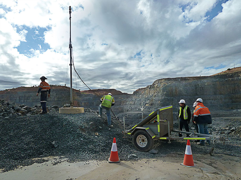
However, with more Jps rovers becoming available, we now tend to make highly accurate predictions about network configuration on the fly. We can now install spare rovers as portable units in light vehicles (LVs) used by technicians onsite. This roaming functionality allows use of the Jps web browser in the rover to instantly validate, in the pit, any changes that may be required for the network before drilling and digging equipment is moved into place. Thus we can monitor real-world signal conditions in specific areas and adjust LocataLite positions to optimize positioning availability for machines that will soon arrive.
The typical network monitoring scenario nowadays is to quickly move a JPS-enabled LV onto a bench or area yet to be drilled or excavated, and review the signals from the individual LocataLite transmitters in real time. Technicians then make any necessary placement changes to the network in advance of any mining equipment arriving. Our ability to now ensure maximum possible positioning and navigation coverage at all times was undreamt of even 12 months ago.
Dual Rover. A modified HP Leica Drill JS System utilizing a Dual Jps Locata Rover has been installed into the drilling supervisors’ LV wagon. The drilling superintendent and supervisors had been exploring ways of moving towards a paperless system that could not only check the drill pattern itself, but also the areas being mined around the pattern. They identified a use-case example where having accurate positional information available in a vehicle enables supervisors to quickly review the construction and positioning of the protective windrows around the drill patterns. Access tracks and bench heights could also be checked without needing to call surveyors in to help. This degree of instantaneous clarity removes the guesswork associated with windrow construction, designed to provide a safety barrier between trucking and drilling operations. Incorrectly placed windrows can lead to potential flow restrictions in either operation, so getting it right the first time in active areas is important.
Mark-up by Night. Drilling supervisors can now accurately measure and monitor progress across the drill patterns using Locata technology to display virtual maps of all active drilling areas. Another spin-off benefit has been the introduction of a fixed point mounted to the front vehicle bullbar, to provide emergency mark-up of patterns during the nightshift when surveyors are not available on site. This helps particularly when a localized Wi-Fi outage prevents drills from downloading the blast pattern to commence drilling operations in an area of the mine. Before Jps, use of this high-precision GPS technology in vehicle had been considered ineffective and impractical because of the unreliable GPS coverage in the bottom of both pits. Plans are now under way to install a similar system into the shovel and auxiliary supervisors’ vehicles.
Forward! Recent group discussions found consensus that the best way to move forward with this technology now is continued integration into GPS, rather than stand-alone systems. Miners are generally a cautious lot: we could hedge our bets through a combined GPS+Locata solution package. Full-scale integration of Locata technology into future standard GPS products is perceived as a way companies such as NovAtel can provide the total package. We envisage a unified system available from all positioning receiver manufacturers that combines the benefits of GPS technology with the evident improvements and back-up that Locata has provided for environments where GPS is unable to function.
We have been in the enviable position of gaining a glimpse into the future, when the power of GPS-style positioning is improved to fill the GPS holes. The results we have obtained are, frankly, addictive. Having experienced this revolution first-hand, it would now be extremely painful to even contemplate going back to our previous GPS-only world.
Locata Fills Satellite Availability Holes in Obstructed Environments
By Chris Rizos, Nunzio Gambale, and Brendon Lilly
An integrated GNSS+Locata system installed on drills, shovels, and bulldozers — the full complement of high-precision machines on site — at Australia’s Newmont Boddington Gold Mine has increased positioning accuracy and availability, as well as mine operational efficiencies, demonstrating an improvement in availability over GNSS-only of 75.3 to 98.7 percent.
Many of the new paradigms in mining have at their core the requirement for reliable, continuous centimeter-level positioning accuracy to enable increased automation of mining operations. The deployment of precision systems for navigating, controlling, and monitoring machinery such as drills, bulldozers, draglines, and shovels with real-time position information increases operational efficiency, and the automation reduces the need for workers to be exposed to hazardous conditions.
GPS singly, and GNSS collectively, despite their accuracy and versatility, cannot satisfy the stringent requirements for many applications in mine surveying, and mine machine guidance and control. Increasingly, open-cut mines are getting deeper, reducing the sky-view angle necessary for GNSS to operate satisfactorily.
A new terrestrial high-accuracy positioning system can augment GNSS with additional terrestrial signals to enable centimeter-level accuracy, even when there are insufficient GNSS (GPS+GLONASS) satellite signals in view for reliable positioning and navigation. Locata relies on a network of synchronized ground-based transceivers that transmit positioning signals that can be tracked by suitably equipped user receivers.
In September 2012, Leica Geosystems launched the first commercial product integrating GNSS and Locata capabilities into a single high-accuracy and high-availability positioning device for open-cut mine machine automation applications: Leica Jigsaw Positioning System (Jps) – Powered by Locata. This article describes technical aspects of this technology and presents positioning results of actual mine operations.
In the near future — perhaps by 2020 — the number of GNSS and augmentation system satellites useful for high-accuracy positioning will increase to almost 150, with perhaps six times the number of broadcast signals on which carrier phase and pseudorange measurements can be made. However, the most severe limitation of GNSS performance will still remain: the accuracy of positioning deteriorates very rapidly when the user receiver loses direct view of the satellites. This typically occurs in deep open-cut mines as well as in skyscraper-dominated urban canyons.
Locata’s positioning technology solution provides an option either to augment GNSS with extra terrestrial signals, or to replace GNSS entirely. Locata relies on a network of synchronized ground-based transceivers (LocataLites) that transmit positioning signals that can be tracked by suitably equipped user receivers. These transceivers form a network (LocataNet) that can operate in combination with GNSS, or entirely independent of GNSS.
Pseudolites are ground-based transmitters of GPS-like signals. Most pseudolites developed to date transmit signals at the GPS frequency bands. Both pseudorange and carrier-phase measurements can be made on the pseudolite signals. The use of pseudolites can be traced back to the early stages of GPS development in the late 1970s, when they were used to validate the GPS concept before launch of the first GPS satellites.
In 1997, Locata Corporation began developing a technology to provide an alternate local GPS signal capability that would overcome many of the limitations of pseudolite-based positioning systems by using a time-synchronized transceiver. The LocataLite transmits GPS-like positioning signals but also can receive, track, and process signals from other LocataLites. A network of LocataLites forms a LocataNet, and the first-generation system transmitted signals using the same L1 frequency as GPS. Time-synchronized signals allow carrier-phase single-point positioning with centimeter-level accuracy for a mobile unit. In effect, the LocataNet is a new constellation of signals, with some unique features such as having no base station data requirement, requiring no wireless data link from reference station to mobile receiver, and no requirement for measurement double-differencing.
Improvements dating from 2005 use a proprietary signal transmission structure that operates in the license-free Industry Scientific and Medical (ISM) band (2.4–2.4835GHz), known globally as the Wi-Fi band. Within this ISM band, the LocataLite design allows for the transmission of two frequencies, each modulated with two spatially-diverse PRN codes. From the beginning the driver for the Locata technology was to develop a centimeter-level accuracy positioning system that could complement, or replace, conventional RTK-GNSS in environments such as open-cut mines, deep valleys, heavily forested areas, urban and even indoor locations, where obstruction of satellite-based signals occurs.
Leica Geosystems has been testing Locata in the Newmont Boddington Gold Mine (NBG) in Western Australia for several years. In 2006, NBG started installing Leica Geosystems high-precision GPS-based guidance systems for fleet management. The mine operators determined early on that as the pit grew deeper, they would need an alternative positioning system for these guidance systems to continue working for the life of the mine. In March 2012, Leica Geosystems deployed a world-first production version of its Jigsaw Positioning system, integrating GNSS+Locata, at the NBG mine.
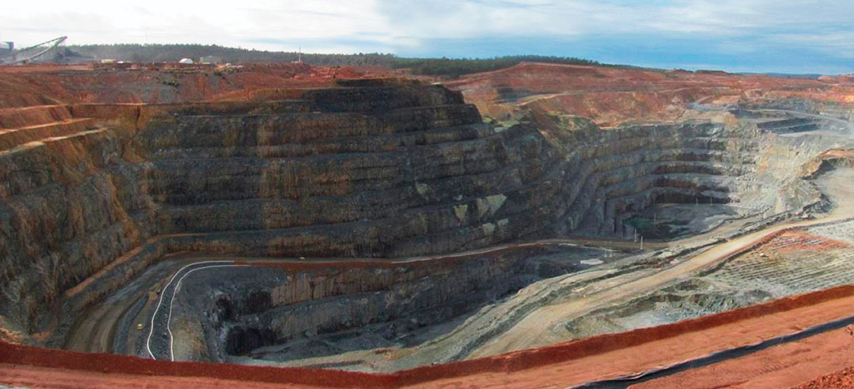
Expected to become Australia’s largest gold producer, the mine consists of two pits (Figure 1). The North Pit at NBG is currently about 1 kilometer long, 600 meters wide, and now approaching 275 meters deep.
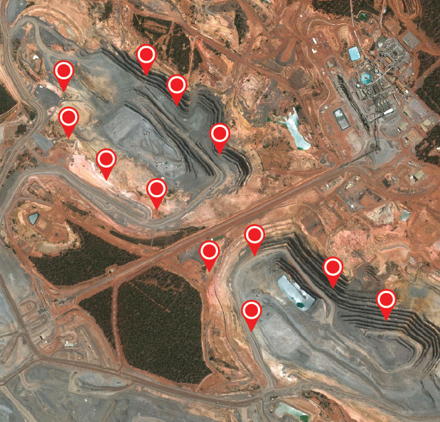
Figure 1. Location of 12 LocataLites at NBG Mine.Figure 2. The Newmont Boddington pit, 900 feet deep and going deeper all the time, creates difficulties for GNSS equipment positioning the mine’s heavy machinery.
A single LocataNet consisting of 12 LocataLites was deployed during April and May 2012 in an initial installation designed to cover both pits in the mine. The results presented here are taken from tests in the North Pit.
Leica’s version of the LocataLite is solar-powered and designed to be placed in the best locations to achieve the maximum benefit. As no special consideration for the location of a transmitter base station is required, the LocataLites can be placed in areas on the rim of the pit or just above the machines operating in the pit floor. The only set-up requirement is that they are able to see at least one other LocataLite to synchronize their transmissions to around 1 nanosecond or better throughout the mine.
Each Jps transmit tower has four small patch antennas mounted in an array. The uppermost is a GNSS antenna used to self-survey the top of the tower, and hence derive the positions of the other antennas below it on the tower. The Locata transmit 1 antenna is mounted directly under the GNSS antenna. The Locata receive antenna is directly under that, and the Locata transmit 2 antenna is around two meters lower down on the tower.
All the antennas are separated by a known distance, and the LocataLite transmit antennas can be tilted down into the pit to maximize the signal broadcast into the area. Each LocataLite transmits four independent positioning signals, two signals from each transmit antenna. These signals provide a level of redundancy and greatly assist in the mitigation of multipath problems in the pit, thereby contributing to the robustness and reliability of the positioning solution.
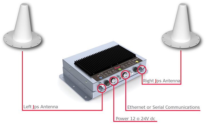
Jps receivers were first installed on two production drill rigs in April 2012. Installation on drills was the highest priority because they are the machines at NBG that operate closest to pit walls and other obstructions, and therefore stood to benefit most from having more reliable positioning. Each Jps receiver incorporates two GNSS and two Locata receivers (Figure 3). One GNSS and Locata receiver pair is connected to a co-located antenna on one side of the machine and the other GNSS and Locata receiver pair is connected to the other co-located antenna. The GNSS receivers obtain their RTK corrections from an RTK base station. The Locata receivers do not require any corrections. The system uses the NMEA outputs from both pairs of receivers to determine the position and heading of the drill rig for navigation purposes.
Figure 3. Jps receiver with integrated GNSS and Locata receivers and two receiver antennas.
The goal of the Jps receiver is to improve the availability of high-accuracy RTK positions with fixed carrier phase integer ambiguities. The results presented here are therefore divided into three sections:
Improvements in availability over a two-month period for all the data in the North Pit.
Improvements in availability for an area in the pit where the GNSS savings are expressed in dollar terms.
Accuracy results achieved and maintained in this GNSS-degraded area.
The performance results shown here are real-world samples of the system operating on drills at NBG. However, it will be appreciated that GNSS satellites are in constant motion, so GNSS-only position availability in different parts of the pit changes by the hour. The results therefore only apply to those drills in those positions in the pit at that time.
Another drill a little distance away in the same pit could experience far better or far worse GNSS availability at exactly the same time.
Overall Availability
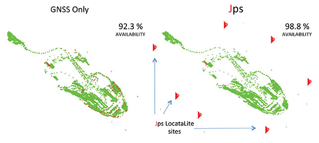
Figure 4 shows the performance difference between using GNSS-only (left) and Jps GNSS+Locata (right). The data for these plots was recorded for the two drills that contained the Jps receiver in the North Pit during the months of April and May 2012. A green dot represents the time the receiver had a RTK fixed solution, and a red dot represents all other lower-quality position solutions — essentially when the receiver was unable to achieve the required RTK accuracy because of insufficient GNSS signals or geometry.
Figure 4. Plots of availability and position quality in the North Pit at NBG for April and May 2012 for GNSS (left) and Jps (right). Green = RTK (fixed) solution, Red = all lesser quality solutions.
Although the availability of GNSS-only RTK fixed position solutions was reasonably good over this entire area, being at the 92.3 percent level at that time, the Jps nevertheless provided a measurable improvement of 6.5 percent to availability, bringing it up to 98.8 percent. Considering that during those two months, the two drills spent a total of 72.24 operational days in the North Pit, this improvement equates to nearly 4.7 days or 112.7 hours of additional guidance availability.
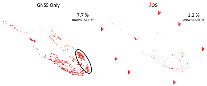
Figure 5 highlights the low positional quality for the GNSS-only solutions and how Jps significantly improved the availability in areas of limited GNSS satellite visibility.
Figure 5. Plots showing non-RTK quality positions, demonstrating that Jps can help reduce lesser-quality RTK solutions. (Performance in the circled area is highlighted in more detail in Figure 6.)
Availability in Poor GNSS Visibility
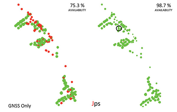
The ellipse in Figure 5 highlights a particular location in the North Pit where GNSS positioning consistently struggles due to the presence of the northern wall and to a lesser extent from the eastern wall. The integration of GNSS and Locata signals improved availability as shown in Figure 6, which in this case increased by 23.4 percent.
Figure 6. Zoomed-in area where GNSS performance was poor between May 2 and May 4, 2012. The circled area shows where the accuracy tests were performed.
As the machine downtime due to not having a RTK position costs the mine approximately U.S. $1000 per hour for each drill, the improvement in availability of 112.7 hours for just the two drills shown in Figure 5 over the two months equates to a savings of $112,700 in operational costs. This productivity increase is significant, considering that the GNSS-only availability in this case still seems relatively good at 92.3 percent. If the GNSS availability for those two months was more like 75 percent — as was the case shown in Figure 6 for the two days in May — then the cost savings become far greater, approaching nearly $400,000, for just two drills over two months. Even a small increase in productivity brings a significant financial benefit ($110,000 per hour) when all 11 drill rigs running in the mine are affected by loss of GNSS positioining availability, yet continue to operate with Jps.
Today all 11 drills in the pits have been fitted with the Jps GNSS+Locata Receivers. As a point of reference to emphasize the level of operational savings: if the Jps had been fitted to all 11 drills during the April and May 2012 period shown in the above results, the cost savings at that time would have been on the order of $1,000,000. It is clear that the savings in production costs that can be gained from improving the availability to the fleet guidance system has a significant impact on the return-on-investment, potentially covering the installation costs within months of deployment. It should also be emphasized that as the pits get deeper, GNSS availability will only degrade further, and the evident production and dollar benefits of the integrated GNSS+Locata system become even larger.
Relative Accuracy
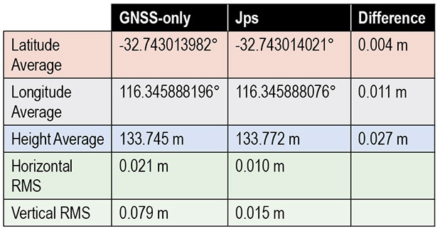
The above levels of improvement in availability are of no benefit if the position accuracy is not maintained within acceptable limits. In order to compare the relative accuracy between the two systems, a dataset was taken from the same data above (circle in Figure 6) when the machine was stationary.
The average position difference between the GNSS-only and Jps receivers for the hour-long dataset was 1.2 centimeters horizontally and 2.7 cm in the vertical component (Table 1). The spread of the position solutions for the two receivers were comparable in the horizontal, with Jps providing a slightly better horizontal RMS value due to the extra Locata signals being tracked and the stronger overall geometry. Additionally, Jps showed a better RMS in the vertical compared to GNSS-only.
Table 1. Comparison of relative accuracy and RMS between the GNSS-only and GNSS+Locata solutions.
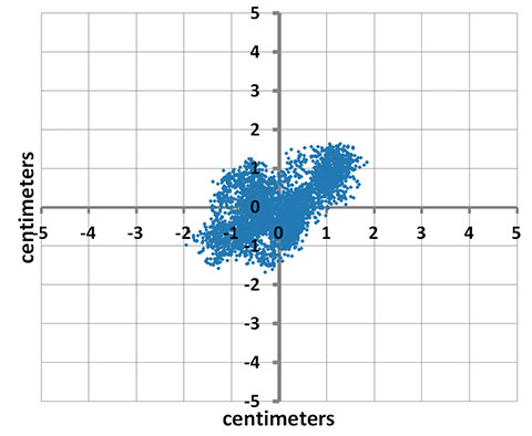
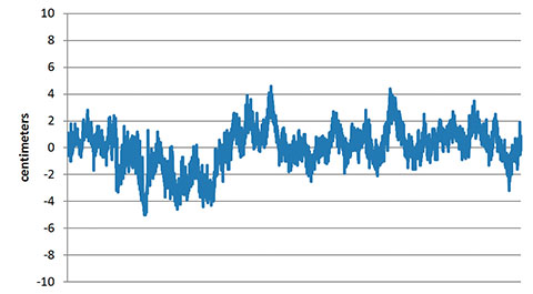
Figure 7a shows the spread of horizontal positions for the Jps receiver, where 0,0 is the mean horizontal position during this time. Note that all the positions are grouped within +/-2 cm of the mean without any outliers. Figure 7b shows the corresponding spread in the vertical positions. These are well within the acceptable accuracy limits required by the machine guidance systems used at the mine.
Figure 7A. Scatter plot of the positions from the Jps receiver over a period of over an hour.Figure 7B. Vertical error for same sample set as Figure 7a.
Concluding Remarks
Based on the experiences at Newmont Boddington Gold, use of Jps has improved the operational availability of open-pit drilling machines by at least 6.5 percent by reducing the outages in 3D positioning caused by poor GNSS satellite visibility commonly associated with deep pits. When Jps is subjected to much harsher conditions closer to high walls, the Jps continues to perform and the improvement in availability compared to GNSS-only is more significant while still maintaining RTK-GNSS levels of accuracy. The additional availability achieved translates directly into cost savings in production for the mine.
Acknowledgments
The first author acknowledges the support on the Australian Research Council grants that have supported research into pseudolites and Locata:
LP0347427 “An Augmented-GPS Software Receiver for Indoor/Outdoor Positioning,”
LP0560910 “Network Design & Management of a Pseudolite and GPS Based Ubiquitous Positioning System,”
LP0668907 “Structural Deformation Monitoring Integrating a New Wireless Positioning Technology with GPS,”
DP0773929 “A Combined Inertial, Satellite & Terrestrial Signal Navigation Device for High Accuracy Positioning & Orientation of Underground Imaging Systems.”
The authors also thank the many people that have contributed to the development of the Leica Jps product. The Leica Geosystems Machine Control Core and CAL teams in Brisbane and Switzerland, other Hexagon companies such as Antcom Corporation and NovAtel, the Locata team in Canberra and the United States, and the people at Newmont Boddington Gold that have gone out of their way to make this a success.
Chris Rizos is a professor of geodesy and navigation at the University of New South Wales; president of the International Association of Geodesy; a member of the Executive and Governing Board of the International GNSS Service (IGS), and co-chair of the Multi-GNSS Asia Steering Committee.
Nunzio Gambale is co-founder and CEO of Locata Corporation, and represents the team of engineers who invented and developed Locata.
Brendon Lilly is the product manager for the Leica Jps product at Leica Geosystems Mining and has worked for more than 20 years in both software and hardware product development. He has a Ph.D. from Griffith University.
In recent years, the sporting world has seen an explosion in the use of GPS. You will rarely spot a runner or cyclist on the road without either a smartphone strapped to their arm or a dedicated GPS device clamped to their handlebars, tracking their every move.
The amount of information that the modern sportsperson — from casual amateur to full-time professional — logs, analyzes, and shares is phenomenal. There are now dozens of ways of uploading data for the whole world to share and study.
As more manufacturers come to this market with the hope of capturing a share of it, they face the challenge of effectively developing and then testing their devices. Among many factors to consider, new products must have capability for local constellations such as BeiDou, GLONASS, and QZSS, not just GPS alone. New market entrants won’t have the same budget as the established big players, and constantly traveling to China or Japan to try out a new gadget will escalate costs to an unsustainable degree.
Then there’s the issue of getting out into the kind of environment in which you imagine your new sporting GPS device will be put to use. In many cases this will be remote: forests, hills, and mountains. Stepping outside to the office car park does not constitute a sufficient test for satellite acquisition and retention. Neither does simply driving the commute route home with it.
A GPS simulator or replay device allows for bench testing, but such devices are expensive. They might not actually fulfill your testing requirements, either: a traditional GPS simulator outputs its scenarios based on constellation modeling, either as a perfect signal or one that has simulated multipath. But you need to genuinely know how your new product will operate through, say, a forest on a downhill mountain bike run, or during a city marathon through urban canyons, or on a trail under wet trees. Adventure sport participants want to record their achievements wherever they go.
How do you obtain this kind of realistic scenario? It will require the use of a GNSS recorder, and in an ideal world you would lend it to someone who actually does some of this stuff. Perhaps one of your colleagues is an (insane) downhill skier — who better to capture exactly that type of data, which you can replay back in a nice warm lab?
The trouble is that a person of this sporting ilk will be unwilling or unable to carry bulky equipment that weighs several kilos. It will slow them down, so a GNSS recorder that can be easily carried without affecting the sporting activity is essential. It has to be easy to use: self-contained, with a battery that will last a couple of hours, and with one big button to start and stop recording. The user shouldn’t need any training in its operation. And ideally, it won’t need a large ground-plane antenna to capture usable data; a well-designed unit will employ a sensitive GPS engine allowing for as complete a signal as possible to be logged through a standard passive antenna.
Looking further afield, other industries will soon be seeking a device with this level of convenience. For instance, agricultural and automotive manufacturers want the ability to send test engineers out to record drive-cycle tests easily and in a variety of vehicles. Additional features, such as controlled area network (CAN) and inertial sensor logging, synchronized with the GNSS data, will also find favor.
The nature of the simulation market is changing: increasing numbers of developers need not just a traditional constellation simulator, but rather a replay device that is feature-rich and that doesn’t cost the earth.
Economies of scale will likely dictate the way that this develops, and GNSS simulation will no longer be the specialist and exclusive field it once was.
Mark Sampson is the LabSat product manager for RaceLogic, based in Buckingham, UK.
An occasional reader of these pages forwarded a clipping from a summer Wall Street Journal, a book review of the new title, Curiosity: How Science Became Interested in Everything, by Philip Ball (University of Chicago Press, 465 pages, $35).
The book covers scientific advances logged in the 1600s, a century that “began with an essentially medieval outlook and ended looking like the first draft of the modern age.” However, the book’s description by WSJ reviewer Timothy Ferris quickly called to my mind the current status of investigation — practiced with an overlay of capitalism and market advantage-seeking — by, guess who, the GNSS community.
Not that I’m necessarily equating the scientists, engineers, and product managers who are responsible for most of the contents of this magazine with the “thousands of independent tinkerers, inventors, collectors and flat-out oddballs, the ‘virtuosos’ as they were called, [who] experimented with lenses, pumps, and biological specimens as much to satisfy their own inquisitiveness as to answer big questions.”
Far from it. Perish the thought.
And yet, and yet . . . .
I sat in a Denver airport cafe on my way home from ION GNSS+, chatting with a couple of industry captains about the way forward. We joked about how our kids will look at us as old fogeys — heck, they already do — tentatively feeling our way to indoor navigation. This method, that method? This augmentation, that integration?
The rising generations will simply take it for granted: indoor nav works everywhere, all the time, in the palm of your hand, or perhaps in the frame of your eyewear. How quaint were those early 21st-century inventors! Tinkering with different RF bands, trying to cobble together a solution.
The smiles on the faces of these industry captains as they proudly showed each other their devices, running their latest prototypes, and curiously examined their competitors’ versions, betrayed an enthusiasm, not just for market share, but for intellectual stimulation, the thrill of the chase, the joy of solving a problem. In that way, they were not unlike the 16th century crew, an assemblage that included, among many minor and forgotten names, Galileo (!!!), Kepler, Newton, Descartes, and Leibniz.
“The truth is that science works,” writes Philip Ball, “only because it can break its own rules, make mistakes, follow blind alleys, attempt too much — and because it draws upon the resources of the human mind, with its passions and foibles as well as its reason and invention.”
Avenza’ PDF Maps app is now available at the Google Play Store.
Avenza Systems Inc., producers of MAPublisher cartographic software for Adobe Illustrator and Geographic Imager geospatial tools for Adobe Photoshop, announce that PDF Maps app is now available on the Google Play Store. The first and only geospatial PDF and GeoTIFF reader for Android devices, Avenza said, the PDF Maps app is unique to the space due to its extensive collection of more than 100,000 detailed maps sourced from well-established publishers, cartographers, government agencies and aficionados of outdoor recreational activities, all of which are downloadable directly from within the app.
PDF Maps take advantage of geospatial technology that allows consumers to view maps and measure real world distances and areas. Paired together with mobile devices that use GPS such as Androids, the PDF Maps app provides constant access to geographic locations and even points of interest without the risk of losing reception due to cell tower proximity.
Designed with its audience of travelers and outdoor enthusiasts in mind, Avenza’s PDF Maps app has already garnered accolades from the International Map Industry Association (IMIA) and Geospatial World for its innovative use of technology on the iOS platform in 2011 and 2012. Since then, its versatility for recreational or business purposes out in the field has been recognized across several industries and it’s gaining momentum.
“The market is currently saturated with map apps that are limited in map data, or too simplified to be functional for offline navigating. We wanted to address those issues by providing a free navigational app that catered to a segment of users who needed something more substantial than the average turn-by-turn digital maps offered today, while providing map-publishers with an iTunes-like environment for distributing their maps direct to devices” said Ted Florence, President of Avenza Systems Inc.
“With Avenza’s PDF Maps app Android users can do more than just view their location. PDF Maps provides a meaningful interface to measure distances, drop placemarks and share personal recorded data in various formats. It’s more than just a viewing tool, but will provide the Android market the best of both worlds — access to maps from well-known paper map publishers that work in tandem with the functionality of GPS devices. We’re thrilled to finally make it available to a new market.”
Unlike other map apps that provide one view of a location using GPS coordinates as most maps do, Avenza’s PDF Maps app expands a traveler’s choices, allowing them to access detailed geography or points of interest created by specific map publishers for use on land, sea or air. PDF Maps app for Android allows consumers to access information while at a destination, providing users an opportunity to make the most of their time experiencing their environment rather than searching for cell reception to access directions.
Currently, Avenza’s vast PDF Maps app library covers maps for domestic and international travel organized by state and area. Android users will appreciate the breadth of tool management features available. All maps — free and purchased — are accessible through the in-app map store and offer the following capabilities:
Add maps from the file system, Dropbox, a URL, email, or Map Store
Browse, purchase, and download maps from the Avenza Map Store (existing iOS PDF Maps accounts are compatible)”
Show GPS position on maps
Add Placemarks
Import and export KML
Find Coordinates
Measure Distance or Area
Open current view in Google Maps
Avenza’s PDF Maps in-app Map Store features a variety of publishers that focus on recreational activities as well as all segments of the map-use market. Below is a small sampling of maps available:
Camping and hiking including National Park Service maps and other regions of the world
Nautical and marine navigation including NOAA and FAA charts for North America and other regions of the world
Topographic use including USGS and Canadian Topographic maps and other regions of the world
Maps for tourists, transit, travel, special events, historic and much more
PDF Maps is available now in the Google Play Store free of charge. For more information about PDF Maps, visit the Avenza website at www.avenza.com/pdf-maps. Pricing of each map is set by the publisher and free maps remain free to users through the PDF Maps app in-app store.
Amtrak introduces an interactive way to see where trains are and when they are expected to arrive, including information on stations nation-wide, all through a new interactive train locator map built on the easy-to-use, familiar Google Maps interface. The new train location tracking system, available at Amtrak.com, provides near real-time train status of more than 300 daily trains, estimates of arrival times and station information — all in the context of the Amtrak national system map. Checking on train status is the second most popular action on Amtrak.com, just after purchasing tickets.
Source: Amtrak http://www.amtrak.com/train-routes
According to the announcement, in addition to helping passengers plan travel, this new travel resource is an excellent tool for those planning the arrival or departure of family and friends. Users can search for information by train number or name, city name and station name or code.
“This tool creates a new platform for sharing information with our customers, and Amtrak will continue to add helpful layers onto this map such as local travel and tourist information to provide passengers a one-stop location for all their travel needs,” said Amtrak Chief Marketing and Sales Officer Matt Hardison. “This map joins several recent technology-related offerings that have improved the customer experience and changed how Amtrak does business, ultimately changing and enhancing the way customers travel with us.”
Amtrak reports that information provided in the map is aggregated data collected from GPS units on each operating train and other automated systems. The data is transmitted to Google’s cloud, and then transferred to the map. The new tracking system joins several recent technology advancements at Amtrak including expanded and improved Wi-Fi, eTicketing and mobile phone apps. In addition to working with Google to advance new systems for our customers, Amtrak has partnered with other major industry-leading brands, such as Apple and AT&T, to improve the amenities and services provided to passengers.
Thousands of high-speed pursuits by law enforcement take place in the U.S. every year, which can endanger other vehicles and property. A new product aimed at law enforcement is designed to help police track cars during these high-speed chases.
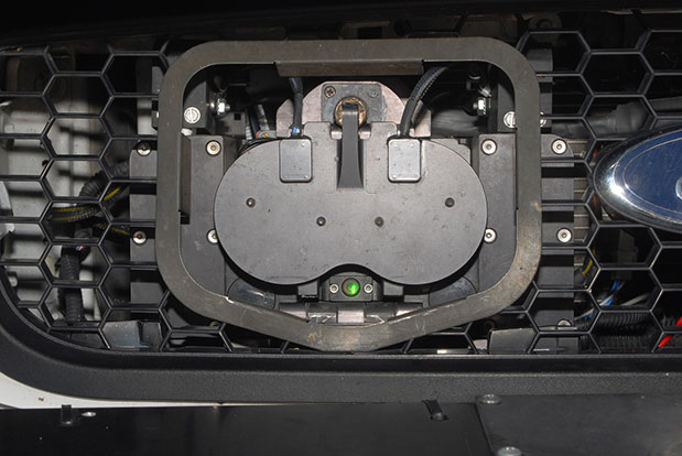
The StarChase system pursuit reduction technology contains a miniature GPS module encased in a tracking projectile/tag and a launcher mounted on a police vehicle. During a pursuit, a GPS tracker tag is shot with compressed air out of a patrol car’s hood onto the car being pursued, to identify the vehicle.
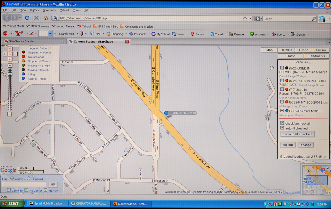
The compressed-air launcher, mounted behind the grille of a police cruiser, uses a laser to target the fleeing vehicle. It discharges a projectile/tag containing the GPS module. The projectile adheres to the suspect vehicle and transmits coordinates back to dispatch. The dispatcher then views the location and movements of the tagged vehicle in near real-time on a digital road map via a secure Internet connection.
Through the efficient use of technology, a high-speed chase has been replaced with a safer interdiction strategy, according to the company.
The StarChase mapping platform is a secure, scalable Web-based solution that does not require special hardware to operate. It is compatible with existing CAD and AVL systems.
The StarChase compressed air launcher under the hood.The StarChase projectile.Tagged vehicles are tracked by dispatch.
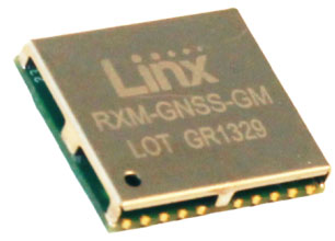
Linx Technologies has launched its GM Series GNSS receiver module. The module is an autonomous, high-performance GNSS receiver designed for navigation, asset tracking and positioning applications of all kinds. Based on the MediaTek chipset, it can simultaneously acquire and track several satellite constellations. These include GPS, Europe’s Galileo, Russia’s GLONASS, and Japan’s QZSS.
The GNSS receiver module provides exceptional sensitivity, even in dense foliage or urban canyons, Linx Technologies said. Hybrid ephemeris prediction can be used to achieve cold start times of less than 15 seconds. By combining this feature with the module’s very low power consumption, battery life is maximized in battery-powered systems.
With an output of standard NMEA data, the GM Series GNSS receiver is self-contained and only requires an antenna. It powers up and outputs position data without any software set-up or configuration, making the GM Series easy to integrate, even by engineers without previous RF or GNSS experience. However, if technical support is needed, our knowledgeable team of engineers can provide guidance.
The GM Series module operates at a low 16mA tracking supply current. This is less than half the supply current of competitive modules.
In addition, the available GPS Master Development System connects a GM Series Evaluation Module to a prototyping board with a color display that shows coordinates, speedometer and compass for mobile evaluation. A USB interface allows simple viewing of satellite data and Internet mapping, as well as custom software application development.
The Compass family of geospatial companies has established Compass4Colorado, a collaborative effort to make high-tech GIS and mapping capabilities available at no or low cost to organizations involved in the recovery activities related to the devastating Colorado floods. Free flood-mapping webinars and workshops will be offered starting in October.
Compass4Colorado offers mapping software, integration services, training and expertise at no charge and equipment rentals at significantly reduced rates to public- and private-sector organizations engaged in flood assessment and recovery. The Compass4Colorado campaign will remain active through March 31, 2014, with support from four additional Colorado companies – Trimble Navigation of Westminster, Laser Technology of Centennial, DigitalGlobe of Longmont, GeoSpatial Experts of Thornton – and Esri of Redlands, California.
“Companies, utilities, and government agencies across Colorado and Nebraska are faced with assessing the full extent of flood damage as recovery begins,” said W. Brant Howard, Founder and Chairman of CompassTools. “We believe that geospatial technologies, especially mobile field data collection, can help this assessment phase proceed more quickly and accurately so the impacted communities can rebuild sooner.”
Before the flood waters had begun to recede, the Compass companies were taking urgent calls from local municipalities and utilities that needed to survey high-water lines, delineate inundation zones, and photo-map damaged assets. CompassTools found that many organizations requesting assistance with assessment activities had some in-house GPS or GIS capabilities, but they required software upgrades, equipment integration or personnel training to deploy them effectively.
“If a Colorado or Nebraska organization in the flood-affected areas doesn’t have GPS or GIS mapping capability, we will make sure they get it,” said Howard. “If they already have the technology, we’re going to make sure they can use it.”
The Compass family of companies, CompassTools, CompassCom and CompassData, are authorized distributors of products and services for Trimble, Laser Technology, DigitalGlobe, GeoSpatial Experts, and Silver Business Partners of Esri.
With support from these organizations, Compass4Colorado includes, but is not limited to, the following offerings at no charge:
Webinar (Oct. 7) and workshops (Oct. 17/Nov. 12) dedicated to field data collection techniques to support assessment and recovery efforts
One-year subscription with configuration service for Trimble Terraflex mobile data collection software
Configuration of TrimbleConnect for water/waste water inspection leveraging Esri ArcGIS Server
Integration of Laser Technology laser rangefinders into GPS data collection workflow
Integration of FEMA inspection workflow on mobile devices
Esri ArcPad and ArcMobile configuration and support
Three-month subscription to GeoSpatial Experts GeoJot+ photo-mapping application
Ground control points to support CompassData processing of DigitalGlobe flood imagery
In addition, Compass4Colorado will offer reduced rates on the following:
Trimble GPS and Laser Technology laser range finder equipment
Field inspection and assessment services
Precision orthorectified DigitalGlobe imagery
For a complete listing of all Compass4Colorado offerings and terms, visit www.Compass4Colorado.com.
The Netherlands Institute of Navigation will be hosting the European Navigation Conference (ENC-GNSS 2014) in Rotterdam, the Netherlands, April 15-17, 2014. The conference will cover all aspects of positioning, navigation and timing (PNT) developments and applications. Special sessions will be organized for innovations and their commercialization.
Abstracts can be submitted until December 31, 2013, at www.enc-gnss2014.com. Topics include, but are not limited to
– Algorithms and Methods: Navigation and Positioning
– Algorithms and Methods: Receiver Signal Processing
– Alternatives and Backups to GNSS
– Atmosphere and Space Weather
– Augmentation Systems
– Aviation Navigation
– eLoran and other LF Systems
– Emerging GNSS
– Galileo IOV Results
– Galileo Public Regulated Service (PRS)
– GNSS Programs, Status and Modernization
– GNSS Vulnerabilities
– Indoor Navigation
– Integrated Systems
– Integrity
– Interoperability and Multi-Constellation Results
– Location Based Services
– Maritime Navigation
– MEMS
– Network RTK, Surveying and Hydrography
– New Products and Services/Business, Economic and IP Aspects
– Precise Point Positioning
– Receiver and Antenna Technology
– Signals of Opportunity
– Simulation
– Spectrum, Interference, Interference Detection and Localisation, Spoofing
– Timing, Time and Frequency Transfer
– TRANSMIT
– Unmanned Aerial Vehicles
– Unmanned Vehicles
– Urban Navigation
Further details about the conference, the venue, and the hosting City of Rotterdam can be found on www.enc-gnss2014.com. Note that the conference is the week before Easter, which is a great opportunity to stay a few days longer and visit the Dutch windmills, tulip fields (they will be in full bloom), and the Port of Rotterdam, one of the greatest in the world.
After a two-week delay, a rocket carrying a GPS instrument designed by University of New Brunswick scientists was launched into space aboard the SpaceX Falcon 9 rocket on September 29. The rocket left Vandenberg Air Force base in California as part of the CASSIOPE (Cascade Smallsat and Ionospheric Polar Explorer) mission.
Dr. Richard Langley, GPS World Innovation editor and professor in geodesy and geomatics engineering at the University of New Brunswick, is a principal investigator behind the scientific portion of the CASSIOPE mission. Langley and his colleagues will monitor data from the GPS instrument, which is part of the Enhanced Polar Outflow Probe (e-POP) payload aboard the spacecraft.
E-POP will continue the sequence of Canada’s orbiting space environment sensors, which began with Canada’s first satellite, Alouette 1, launched in 1962 to study the ionosphere. e-POP is, perhaps, the most extensive suite of sensors for studying the ionosphere/magnetosphere/thermosphere yet to be launched, and will provide Canadian and other scientists with the opportunity to better understand the impact and variability the sun has on the space environment — what we call “space weather.”
A static fire retested the Falcon 9 rocket after several problems cropped up during a hotfire of the launcher’s engines during preparation for the original launch date September 15. The launch was then delayed because the U.S. Air Force Western Range, which controls a network of tracking and communications assets based at Vandenberg, was busy with Minuteman ballistic missile testing.
The small hybrid satellite blasted off on board a Falcon 9 rocket developed by SpaceX, a commercial space company. The Canadian Space Agency became one of SpaceX’s first customers when the agency decided years ago to use the private U.S. rocket to deliver the satellite at a reduced cost of $10 million. It cost the space agency $63 million to develop the satellite.
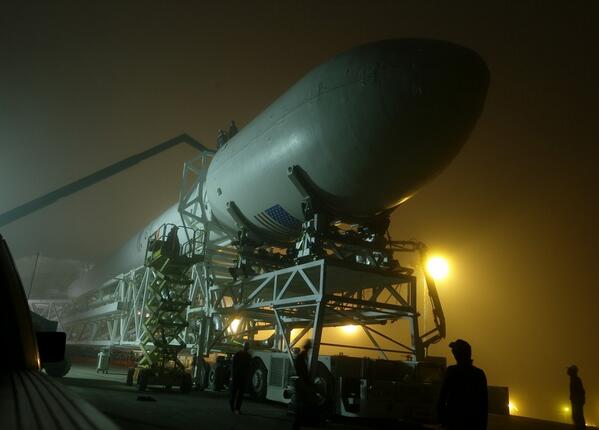
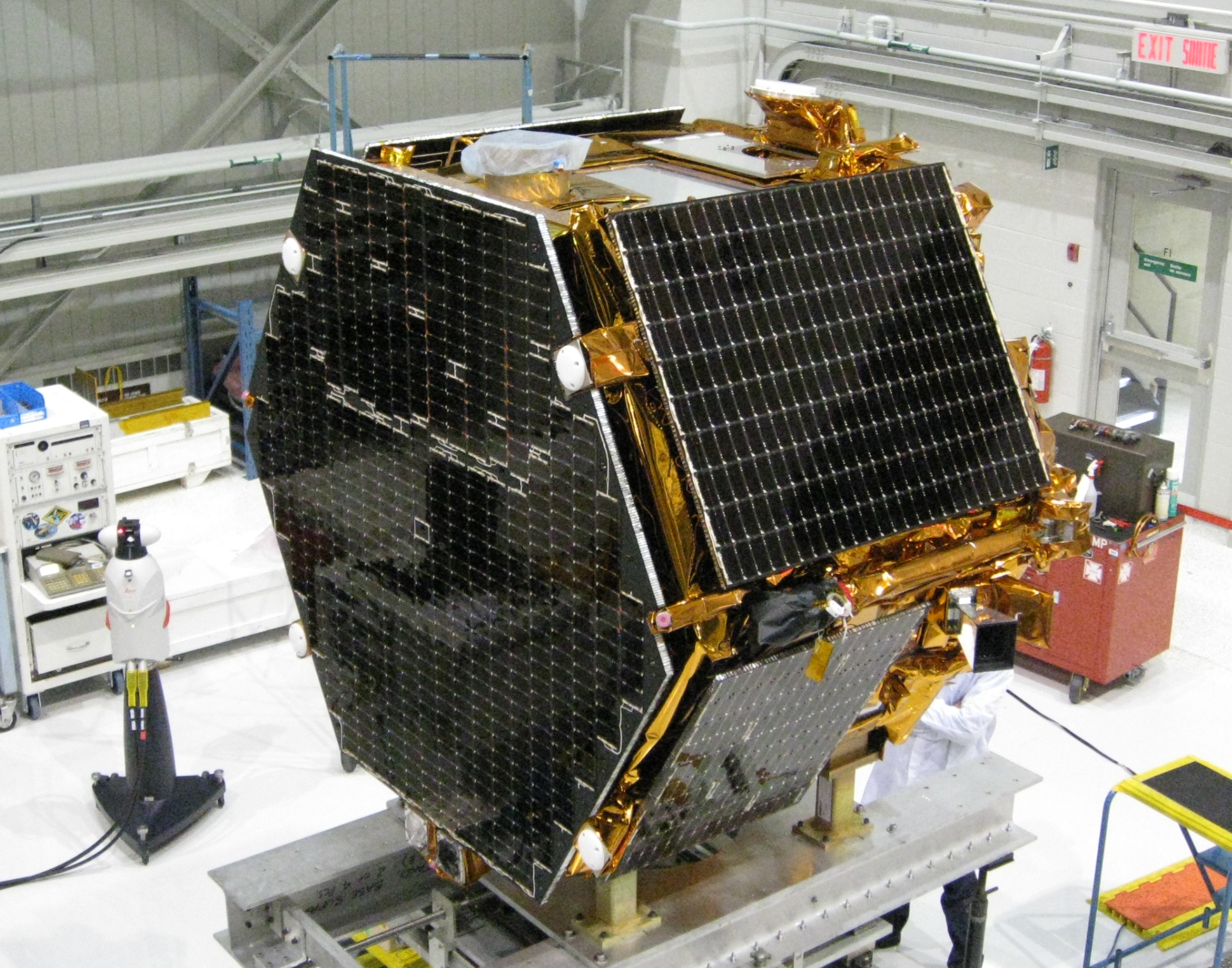
The Falcon 9 rocket, with CASSIOPE inside its fairing, on the way to the launch pad at Vandenberg Air Force Base. (Photo credit: SpaceX).The research satellite CASSIOPE on a test platform at the Canadian Space Agency’s David Florida Laboratory. CASSIOPE hosts the GPS Attitude, Positioning, and Profiling instrument designed by GGE researchers. The four white antennas on the left-facing side of the spacecraft will be used to determine the position, velocity, and attitude of the spacecraft while the antenna on the upper side will be used to profile the ionosphere’s electron density. (Photograph courtesy of MacDonald, Dettwiler and Associates Ltd.)
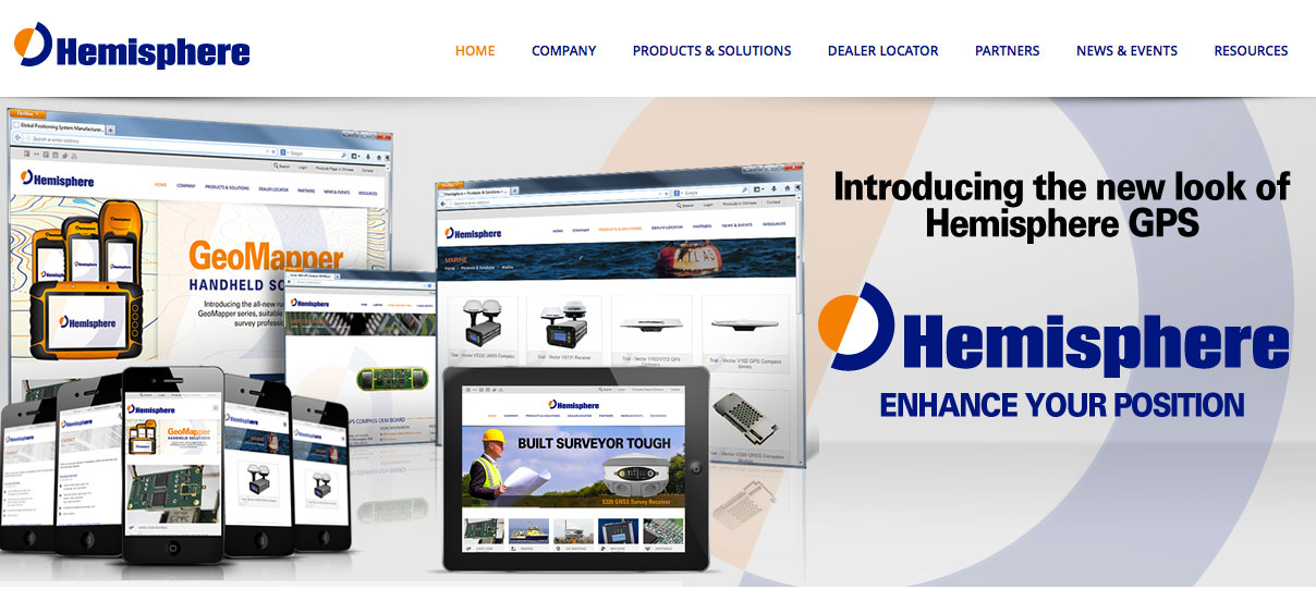
The new Hemisphere GNSS logo uses only the word Hemisphere.
Today, Hemisphere GNSS introduced its new “Hemisphere” corporate branding and logo to reflect its global GNSS focus. The company is also announcing a new website that has been built from the ground up based on customer and partner input.
In February 2013, Hemisphere GPS was renamed and incorporated as Hemisphere GNSS Inc. The company owns both names, but in order to reflect the company’s support of all Global Navigation Satellite Systems (GNSS) and update the company image, Hemisphere GNSS Inc. will be adopting the use of the new “Hemisphere” logo.
“We are pleased to have completed our transition from a GPS agriculture-focused organization to a truly global GNSS Technology and Applications company. Today we are reaffirming our commitment to offering the best value in GNSS OEM boards, antennas, marine positioning, survey, mapping, and machine control products,” said Phil Gabriel, president at Hemisphere GNSS. “We are now introducing our new stylized globe logo and our updated branding to simply read ‘Hemisphere,’ as well as our new website and URL; www.HemisphereGNSS.com.”
The new website is easier to navigate and will assist customers in finding the information they need in a shorter amount of time, the company said. Employee email addresses are also being updated to first name initial, last name @HemisphereGNSS.com, though old email addresses will continue to work for the foreseeable future.