Blog

  • Placecast Unveils PlaceAd Mobile Advertising Platform

    Placecast Unveils PlaceAd Mobile Advertising Platform

    placecast_logoPlacecast has launched PlaceAd to enable media buyers to target and reach mobile audiences based on their location. In addition to location, advertisers can target and optimize messaging across criteria including age, gender, interests, device type and operating system, time of day, and weather.

    PlaceAd is a demand-side platform (DSP) built to maximize the value of location-based inventory on mobile. PlaceAd’s programmatic buying tools, analytics and included dynamic rich media engine are optimized for location-based campaigns. Placecast’s decision engine automatically optimizes campaign performance.  PlaceAd can manage geotargeted campaigns based on the quality of the location data across billions of impressions with integrated reporting and store-level analytics.

    Placecast is also announcing partnerships with some of the largest ad exchanges and supply side platforms (SSPs), including MoPub, PubMatic, and Smaato. With these key partnerships in place, Placecast can provide substantial reach for brands across thousands of mobile publishers and billions of monthly impressions.

    “Mobile advertising, location and real-time bidding are the key ways to reach consumers today, and ad agencies can’t get enough of them,” says Karsten Weide of IDC. “PlaceAd is hitting a sweet-spot in the advertiser market and provides a timely solution for the pain points in reaching mobile audiences locally.”

    Besides access to many different sources of ad inventory, media buyers also get comprehensive location-based reporting down to the most granular level, including heatmaps that provide a visual illustration of the intensity of impressions and engagement by targeted locations.

    Key features of PlaceAd include:

    • Reach across thousands of safe mobile publishers for location-based mobile display inventory: Via partnerships with MoPub, PubMatic, and Smaato
    • Transparency on publishers where campaigns run
    • Real-time bidding: The ability to price and deliver on a per-impression basis in real-time; IAB OpenRTB 2.1 spec compliant
    • Machine Learning and Optimization: Placecast’s decision engine optimizes campaign performance based on activity across placements and publishers to maximize performance.
    • Dynamic Creative: Clients can change elements in the ad based on location, time of day, or other info on the consumer
    • Store-level analytics and reporting: Consolidated campaign reporting shows deliveries, clicks, and other actions across different inventory down to the individual store location. Heatmaps can be used to see campaign activity near targeted areas.
    • Geotargeting using both proximity geofencing and metro-level data.
    • Audience targeting though a number of methods:
      • Contextual targeting based on content
      • Place profiles
      • Third-party audience data
    • Third-Party Ad Serving Support: Agencies can track their campaign data in DoubleClick for Advertisers or Atlas

    “PlaceAd is the latest addition in our toolset that makes it easier for advertisers and agencies to buy location-based mobile campaigns,” said Alistair Goodman of Placecast. “This new offering combines years of geofence marketing expertise with great tools and analytics that together reduce the friction in buying location-based mobile advertising campaigns at scale.”


  • Precision Farming Growth to Be Remarkable, Report Says

    Research and Markets has issued a new precision farming technology report. According to the report, the growth of the market is expected to be remarkable, and is estimated to reach $3.72 million by 2018, at an estimated CAGR of 13.36% from 2013 to 2018. The major players in this industry are Deere & Co. (U.S.), Trimble Navigation (U.S.), Topcon positioning systems (U.S.), Raven Industries (U.S.), Precision Planting (U.S.), and AGCO (U.S.).

    The major drivers for this market are augmented yield and profitability, energy and cost saving, and government assistance. Major restraints such as high initial investments and lack of awareness and their impact analysis are also covered under this study. North America currently leads the market share for precision farming as this region has the maximum adoption. Asia-Pacific (APAC) is the emerging market for precision framing and has been enjoying the highest growth rate among all the geographic regions. It is believed that the APAC market will grow at a CAGR of 25.16% from 2013 to 2018.

    The full title is “Precision Farming Market by Technology (GPS/GNSS, GIS, Remote Sensing & VRT), Components (Automation & Control, Sensors, FMS), Applications (Yield Monitoring, VRA, Mapping, Soil Monitoring, Scouting) – Global Forecast & Analysis (2013 – 2018).”

    The report covers all the technologies, components, and applications of precision farming; it provides a detailed analysis of the current market scenario and estimation for the next five years. Major applications like field mapping and yield monitoring are driving the market. Moreover, the market is driven by important technologies like GPS and variable rate technologies. This market is already progressing well in developed countries and it is also expected to grow well in the developing nations as a result of their ever growing food demands.

    This study describes the value chain for precision framing market by considering all the major stakeholders in the market, and their role analysis. The report also performs a detailed scrutiny of the Porter’s five force analysis for the market. All the five major factors in these markets have been quantified using the internal key parameters governing each of them.

    Key Topics Covered:

    1 Introduction

    2 Executive Summary

    3 Cover Story

    4 Market Overview

    5 Global Precision Farming Market By Technology

    6 Global Precision Farming Market By Hardware & Software Components

    7 Precision Farming Market by Application

    8 Global Precision Farming Market By Geography

    9 Competitive Landscape

    10 Company Profile – Overview, Products And Services, Financials, Strategy & Development

    Companies Mentioned

    • Ag Business & Crop Inc.
    • Ag Leader Technology
    • Ag-Nav Inc.
    • Agco Corporation
    • Agjunction Inc.
    • Agri Con Gmbh
    • American Sensor Technologies Inc.
    • Autofarm
    • Automata Inc.
    • Deere & Company
    • Dickey-John Corporation
    • Echelon Ag Inc.
    • Jain Irrigation Systems Ltd.
    • Omnistar
    • Precision Planting Inc.
    • Precisionagriculture. Com.Au
    • Raven Industries Inc.
    • Soyl Precision Farming
    • Teejet Technologies
    • The Toro Company
    • Topcon Precision Agriculture
    • Trimble Navigation Limited

    For more information, visit the Research and Markets website.

  • Blue Sky Network Debuts Portable M2M GNSS Tracking Solution

    Blue Sky Network Debuts Portable M2M GNSS Tracking Solution

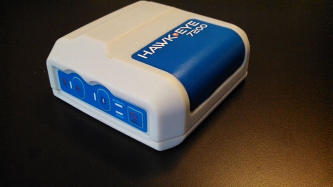
    Blue Sky Network's HawkEye 7200 Portable M2M Tracking Solution.
    Blue Sky Network’s HawkEye 7200 Portable M2M Tracking Solution.

    Blue Sky Network, a supplier of satellite tracking and communication solutions for aviation, land and marine, has launched the HawkEye 7200 portable M2M tracking solution. The HawkEye 7200 includes features such as multinational GNSS receiver support and integrated Bluetooth for Iridium connectivity to smart devices. Designed in a small form factor, the HawkEye 7200 can be powered by battery or via an external power source and is a key addition to Blue Sky Network’s solutions portfolio extending the reach of smart device communications globally anywhere in the world.

    The HawkEye 7200 is Blue Sky Network’s first product to incorporate a multinational GNSS receiver. It combines the major GNSS providers into a single location-based chip that can be used in other parts of the world including GLONASS for Russia and the Galileo for the European Union. This multinational GNSS receiver feature enables fleet operators with globally dispersed assets to obtain position reports with increased accuracy and performance. When used with New SkyRouter, Blue Sky Network’s cloud-based web-portal, the HawkEye 7200 offers portable tracking and resource management of any asset type across the globe. The HawkEye 7200 hosts an RS232 interface and digital inputs/outputs for connectivity and control of external sensors or other telematics devices.

    With the integrated Bluetooth connectivity, the HawkEye 7200 supports Blue Sky Network’s new iPhone/iPad application. The application allows users to send emails, short-code messages and customizable electronic forms through the Iridium network. With the ability for operators to build and fully customize forms — such as flight plans, maintenance records and logistic records of remote assets — HawkEye 7200 supports the industry’s movement toward paperless fleet operations.

    “Blue Sky Network is a long-time member of the Iridium partner ecosystem and is continuously delivering cutting-edge M2M communication solutions targeting new markets,” said Bryan Hartin, executive vice president, commercial sales and marketing of Iridium. “The HawkEye 7200 is yet another solution from Blue Sky Network that offers powerful capabilities and applications that utilize the Iridium network. Together we are providing customers with critical connectivity worldwide.”

    “The HawkEye 7200 further bolsters our leadership position in the mobile resource management and tracking industry,” said Blue Sky Network’s CEO and founder, Jon Gilbert. “Combining our HawkEye 7200 with our iPhone/iPad application and our industry-leading backend web portal, New SkyRouter, our customers have a complete end-to-end solution to link the far reaches of the world right in the palm of their hand. We are shrinking the global communication barrier and improving the methods by which people anywhere make connections to manage critical assets and communicate.”

    Blue Sky Network is showcasing the HawkEye 7200 at the Helitech International Helicopter Expo & Conference, in London on September 24-26, in booth #B59.

    The new HawkEye 7200 is in process of being certified by Iridium, with production expected in Q4 2013.

  • GPS III Prototype Successfully Integrated with OCX Ground Control Segment

    GPS III Prototype Successfully Integrated with OCX Ground Control Segment

    During the August test, the GPS III Non-flight Satellite Testbed (GNST) proved that it could connect with and receive commands from the Launch and Check Out System.
    During the August test, the GPS III Non-flight Satellite Testbed (GNST) proved that it could connect with and receive commands from the Launch and Check Out System.

    The prototype for Lockheed Martin ‘s next generation GPS III satellite reached a major milestone on August 30 when it successfully established remote connectivity and communicated with the GPS Next Generation Operational Control System (OCX), being developed by Raytheon, during a series of pre-flight tests.

    During the Compatibility and Integration (C&I) Tests, Lockheed Martin’s GPS III Non-flight Satellite Testbed (GNST) — a full-sized, functional satellite prototype currently residing at Cape Canaveral Air Force Station — proved that it could connect with and receive commands from Raytheon’s Launch and Check Out System (LCS), part of the next-generation OCX that supports the satellite and mitigates risks prior to launch.

    The GNST received commands from the LCC node at Lockheed Martin’s facility in Newtown, Pennsylvania, via the OCX servers at Raytheon’s facility in Aurora, CO, the system then returned satellite telemetry to the control station. The tests mirror launch and early orbit testing planned for all flight vehicles.

    “The GNST is essentially a non-flying, functional GPS III satellite. While we have connected OCX with ground-based simulators before, these C&I tests were the first time that OCX and a GPS III satellite have actually communicated,” explained Keoki Jackson, vice president for Lockheed Martin’s Navigation Systems mission area.

    Matthew Gilligan, a vice president with Raytheon’s Intelligence, Information and Services business and Raytheon’s GPS OCX program manager, stated, “This was an invaluable early opportunity to demonstrate command and control of the GPS III satellite with LCS, proving the end-to-end system capabilities well before putting an actual GPS III in orbit. The positive results tell us that we are right on track for the first GPS III launch.”

    The LCS works hand-in-hand with Lockheed Martin’s Launch and Checkout Capability (LCC) contract, which brings online some of OCX’s GPS III-specific capabilities early to provide on-orbit checkout and control of the satellites.

    The GNST has been at the Cape since July dry-running launch base space vehicle processing activities and pre-launch testing that all future flight GPS III satellites will undergo. The first flight GPS III space vehicle (SV-01) is expected to be available for launch in 2014, and launched by the U.S. Air Force in 2015.

    Prior to shipment to the Cape, the GNST was developed and then completed a series of high-fidelity activities to reduce program risks, improve efficiencies and pathfind the integration, test and environmental checkout that all production GPS III satellites undergo at Lockheed Martin’s new GPS III Processing Facility in Denver, Colo.

    An innovative investment by the Air Force under the original GPS III development contract, the GNST has helped to identify and resolve development issues prior to integration and test of SV-01. Following the Air Force’s rigorous “Back-to-Basics” acquisition approach, the GNST has gone through the development, test and production process for the GPS III program first, significantly reducing risk for the flight vehicles, improving production predictability, increasing mission assurance and lowering overall program costs.

    The Lockheed Martin-developed GPS III satellites and Raytheon’s OCX are critical elements of the U.S. Air Force’s effort to modernize the GPS enterprise more affordably while improving capabilities to meet the evolving demands of military, commercial and civilian users worldwide.

    GPS III satellites will deliver three times better accuracy; provide up to eight times more powerful anti-jamming capabilities; and include enhancements which extend spacecraft life 25 percent further than the prior GPS block. The GPS III also will carry a new civil signal designed to be interoperable with other international global navigation satellite systems, enhancing civilian user connectivity. The spacecraft bus and antenna assemblies for the first GPS III satellite have been delivered to Lockheed Martin’s GPS III Processing Facility and are in the integration and test flow leading to the planned space vehicle delivery in 2014.

    Lockheed Martin is currently under contract for production of the first four GPS III satellites (SV 01-04), and has received advanced procurement funding for long-lead components for the fifth, sixth, seventh and eighth satellites (SV 05-08).

    OCX will revolutionize GPS command and control and mission management capabilities, controlling all legacy and new military and civil signals, providing protection against evolving cyber threats and ensuring continuity of operations during cyber attacks, and reducing operation and sustainment costs through efficient software architecture, automation and performance-based logistics. OCX represents a quantum leap in capabilities over the current Operational Control System and provides flexibility and adaptability to meet future GPS mission needs. Raytheon is the OCX prime contractor and is on track to deliver the final Launch and Checkout System in 2014.

    The GPS III team is led by the Global Positioning Systems Directorate at the U.S. Air Force Space and Missile Systems Center. Lockheed Martin is the GPS III prime contractor with teammates ITT Exelis, General Dynamics, Infinity Systems Engineering, Honeywell, ATK and other subcontractors. Raytheon is the GPS OCX prime contractor with teammates ITT Exelis, Boeing, Braxton, Infinity Systems Engineering, and NASA’s Jet Propulsion Laboratory. Air Force Space Command’s 2nd Space Operations Squadron (2SOPS), based at Schriever Air Force Base, Colo., manages and operates the GPS constellation for both civil and military users.

  • Kongsberg Unveils Heading and GNSS Surface Position Options for eBird

    Kongsberg Unveils Heading and GNSS Surface Position Options for eBird

    Photo: Kongsberg Seatex

    Kongsberg Seatex has given users of the eBird System the ability to equip SmartWing instrumentation with two additional features — a compass and a GNSS receiver. eBird is a bird concept for lateral, vertical and roll streamer control in marine seismic acquisition that enables fault tolerant and efficient multi-streamer steering by employing a wide range of innovative and patented technological solutions.

    The innovative approach of placing a GNSS receiver in the wings opens new opportunities for improving the efficiency of an operation – in particular during launch and recovery but also when running lines.

    The built-in GNSS receiver has been implemented based on Kongsberg Seatex’ extensive competence within GNSS technology. Transmission of satellite data from the seismic vessel to eBird reduces the time to first position fix considerably – giving eBird a position with one wing semi-surfaced. The built-in compass has been developed based on Kongsberg Seatex’ deep knowledge and experience within sensor technology and is fully integrated with SmartWing. The compass provides heading information from a submerged eBird.

    These add-ons represent further improvements to the eBird streamer positioning and control concept.

    “We always try to find improvements to our solutions and these new features are excellent examples of how we combine our core technology and expertise to create improved value for our customers,” says Gard Ueland, President of Kongsberg Seatex AS. “This is one step further in our offering to the seismic market, and we will continue to improve our solutions in close cooperation with our customers.”

    eBird has, since its introduction at SEG in 2009, gained high attention within the seismic acquisition community with its sleek and functional design and utilisation of innovative technology together with proven performance in large seismic streamer spreads.

  • BioDigital Announces $4M Funding to Create a 3D Model of the Human Body

    BioDigital, Inc. announced they’ve received $4MM in Series A funding led by FirstMark Capital with participation from the NYU Venture Fund and a number of prominent angel investors.

    According to the announcement, BioDigital has been pioneering the use of 3D technology to simplify health concepts for a decade.  Regardless of the customer the underlying problem remained the same: traditional methods of communicating health information were no longer adequate. Furthermore, the consumer appetite for information is unprecedented, but the format its delivered in is hard to digest. 3D technology has already changed the face of games, movies and with geo-browsers like Google Earth the way we navigate our planet, but nowhere does 3D make more sense than in representing the human body. The body is a dynamic, complex system and understanding it using text and static 2D illustration is inherently flawed. BioDigital has been fortunate over the last decade to provide innovative solutions to this problem to a range of healthcare customers such as hospitals, medical schools, device and pharma.

    BioDigital_human-showcase

    Two years ago, BioDigital reports that it saw some profound changes happening in the development of the Web. For the first time, as part of the HTML5 spec,  3D would be natively supported in browsers. Cloud and API based businesses also emerged. BioDigital opines that technology is clearly entering a new phase of the web: a services oriented model which leverages rich interactive media as a better means of conveying information. BioDigital reports these trends inspired it to take its IP  built over the years and create the definitive place for immersive health content on the Web, which is called the BioDigital Human Platform.

    BioDigital reports that since its launch 12 months ago, the Human has exceeded expectations. More than one million members have joined across an array of use cases. Students from over 2500 schools are using it to learn anatomy; consumers are using it to understand and share everything from fitness to health conditions; healthcare providers are now introducing it within their clinics to better communicate with their patients.

    Building the first true 3D virtual body platform that finally allows people to see what’s happening below our skin is a massive undertaking, according to the company blog. BioDigital says the investment will allow it to accelerate the development of features and API functionality requested by its users while furthering its mission to make health and human body understandable to everyone.

  • Ordnance Survey uses OpenData to Create a Minecraft Map of Great Britain

    Great Britain’s Ordnance Survey announced a  team developing ideas for future products and services at Ordnance Survey has created a map of Great Britain in the popular Minecraft video game, featuring 22 billion blocks, using their freely available digital map products in OS OpenData, and made it available for download as a new Minecraft world.

    According to the announcement, the national mapping authority have created a Minecraft world representing over 224,000 square kilometres of Great Britain using two of their OS OpenData products. The Minecraft GB terrain was created using OS Terrain 50, a three-dimensional model of the bare earth surface known as a Digital Terrain Model delivered as a grid with a resolution of 50 metres. The raster version of OS VectorMap District, a mid-scale contextual or backdrop map product, was then used to extract surface features – for example water, woodland and roads – based on pixel colours and densities. This information was then used to modify the material of individual blocks in the Minecraft GB world.

    Ordnance_Survey_RS1334_minecraftexample

    Explaining how the project started, Graham Dunlop, Innovation Lab Manager at Ordnance Survey, said, “The purpose of our Labs team is to explore and assess ideas for new products and services. When Joseph Braybrook joined the team as part of Ordnance Survey’s summer internship programme, we discovered he was an avid Minecraft fan and we decided to explore the potential educational benefits of the popular video game. We decided to build a Minecraft world using free-to-use OS OpenData products to display the landscape and terrain of Great Britain.”

    The new Minecraft GB world, which consists of over 22 billion Minecraft blocks, is now available to download by any of Minecraft’s 33 million active users with a license. Players can use the new world to fly across the country and see different environments such as Snowdonia, Poole Harbour and central London. All players will enter the virtual 3D world at our head office in Southampton and from there can add their own recreations of real-life features – such as landmarks like Stonehenge or add imagined environments such as Hogwarts castle.

    Graham continues, “We think we may have created the largest Minecraft world ever built based on real-world data. It’s impressive to know that despite never having used Java programming previously, Joseph took just two weeks to create the Minecraft GB world. The resulting map shows the massive potential, not just for using Minecraft for computer technology and geography purposes in schools, but also the huge scope of applications for OS OpenData too.”

    Recognising the need to scale the world, the team used coding to take the raw heights in Ordnance Survey’s data and scaled it down to fit within the 256 block height limit in Minecraft. A maximum height of 2,500 metres was chosen, which means Ben Nevis appears just over 128 blocks high. Although this exaggerates the real-world height, it preserves low-lying coastal features such as Bournemouth’s cliffs, adding interest to the landscape.

    Ordnance Survey has also linked the world to their popular OS getamap service to enable players to navigate to some familiar places. Players can use the service to search for a location and capture the grid reference displayed on the screen. Using this, a conversion tool can then generate the Minecraft teleport command with the correct world coordinates.

  • u-blox Releases Improved Sub-Meter GPS Positioning Module NEO-7P

    u-blox Releases Improved Sub-Meter GPS Positioning Module NEO-7P

    NEO-7P
    The NEO-7P sub-meter GPS positioning module with Precise Point Positioning (PPP) and Differential GPS.

    Swiss-based u‑blox has introduced the NEO-7P, an improved, low-power, compact, high-precision GPS module. While remaining backwards compatible with its predecessor NEO-6P, the new module achieves standalone sub-meter precision based on single-frequency precise point positioning (PPP) technology.

    Fully autonomous sub-meter performance can be realized for most outdoor applications within coverage of Satellite Based Augmentation Systems (SBAS) throughout North America (WAAS), Europe (EGNOS), and Japan (MSAS).

    In areas where SBAS is unavailable, the NEO-7P achieves high-accuracy based on Differential GPS (DGPS) positioning as an alternative to PPP. DGPS uses RTCM correction messages (correctional data defined by the Radio Technical Commission for Maritime Services) from a local reference station or aiding network to cancel out measurement error introduced by atmospheric distortion and variances in satellite orbits and clocks.

    “The NEO-7P addresses many requirements for precise positioning used in surveying, mapping, marine, and clear-sky recreational applications,” said Thomas Nigg, VP product marketing at u-blox. “The solution delivers sub-meter positioning performance based on two techniques at a fraction of the cost of other high precision solutions. The solution is compact, requires no external base station, and uses a single frequency receiver.”

    The device comes in u-blox’ compact NEO Leadless Chip Carrier (LCC) module form factor. A UART, USB and I2C interface provide flexible connections to a host processor. It can also communicate directly with u‑blox’ SARA 2G, LISA 3G and TOBY LTE cellular modules.

    The NEO-7P also provides complete GPS satellite raw data allowing further accuracy improvement based on post processing by an external host. Internal Flash memory allows simple firmware upgrades. The NEO-7P also supports Russian GLONASS Japanese QZSS positioning standards.

    The module is suitable for vehicle, industrial and consumer applications.

    Detailed information about the NEO-7P can be found on the u-blox website.


  • Landsat Images Show Devastation Caused by Colorado Floods

    NASA’s Earth Observatory released images illustrating the September floods in Colorado. Though water levels on the South Platte River were receding, muddy brown waters were still out of the river’s banks near Greeley, Colorado, on September 17, 2013, when the Operational Land Imager (OLI) on the Landsat 8 satellite acquired this image. At the time, the river was more than six feet above flood stage, down from more than eight feet above flood stage.

    The image shows that the flood has washed away roads, including sections of U.S. Highway 34. Farmland and a few developed areas are under water. Heavy rain caused flooding across the Front Range of the Rocky Mountains starting on September 11, and much of that water made its way into the South Platte River. The river reached a record 18.79 feet in the early morning hours of September 14. The previous record crest was 11.73 feet. Flood stage is 10 feet. As the water subsides in Colorado, it is expected to swell the river downstream in Nebraska.

    Image acquired June 29, 2013
    Image acquired by NASA June 29, 2013
    Image acquired September 17, 2013
    Image acquired by NASA September 17, 2013

    According to the announcement, as of September 18, floods had affected 17 counties in Colorado, leaving six people dead, 306 missing, and more than 18,000 evacuated, according to the Colorado Office of Emergency Management. Early estimates place the cost of the floods at two billion dollars. Though destructive and costly, all of the excess water may help parts of Colorado recover from drought. The rain helped refill some depleted reservoirs and recharge dry soil. However, it also damaged irrigation infrastructure, so the impact on farmers is mixed.

  • Esri Announces ArcGIS Marketplace, Apps for GIS

    Esri announces the launch of ArcGIS Marketplace, a new destination that allows ArcGIS Online subscribers to search, discover, and get apps and data from qualified providers for use within their organization. ArcGIS Marketplace provides data from organizations such as DigitalGlobe, RapidEye, AccuWeather, and Esri, as well as apps created by Esri and its distributors and partners, such as Latitude Geographics, Azteca Systems, and con terra that are built specifically to work with ArcGIS Online. All apps and data can easily be shared with ArcGIS Online groups and users within your organization.

    Esri_Marketplace“While there are app marketplaces that serve consumer audiences, only ArcGIS Marketplace is specifically designed to serve the needs of GIS users, making it truly unique,” says Johan Herrlin, senior business strategist at Esri. “ArcGIS Marketplace is another facet of the ArcGIS platform. Now you can easily find apps and data services that integrate with your ArcGIS Online subscription, allowing you to get more value out of the platform.”

    According to the announcement, anyone can browse the listings in ArcGIS Marketplace, but you need to be an ArcGIS Online subscriber to get free trials or make purchases. Because all apps in ArcGIS Marketplace require an ArcGIS Online login, users can access their organization’s maps via the apps. Data services acquired via ArcGIS Marketplace are also fully integrated with ArcGIS Online, so you can add them to your basemap gallery or other apps.

    For apps and data service providers, ArcGIS Marketplace provides a mechanism to generate leads, provide free trials, grant access to listings, and manage subscriptions. If you have a great app or data that you would like to make available to the ArcGIS community, find out what it takes to qualify as an ArcGIS Marketplace Provider.

    ArcGIS Marketplace is now available globally.

    Photo: Esri


  • QGIS 2.0 (Dufour) Released

    The Open Source Geospatial Foundation (OSGeo) announced the release of QGIS 2.0. QGIS is a cross-platform free and open source desktop geographic information systems (GIS) application that provides data viewing, editing, and analysis capabilities.


    What’s new in QGIS 2.0

    User Interface

    • New icon theme: We have updated our icon theme to use the ‘GIS’ theme introducing an improved level of consistency and professionalism to the QGIS user interface.
    • Side tabs, collapsable groups: We have standardised the layout of tabs and introduced collapsible group boxes into many of our dialogs to make navigating the various options more easy, and to make better use of screen real estate.
    • Soft notifications: In many cases we want to tell you something, but we don’t want to stop your work or get in your way. With the new notification system QGIS can let you know about important information via a message bar (colour depends on the importance of the message) that appears at the top of the map canvas but doesn’t force you to deal with it if you are busy doing something else. Programmers can create these notification (e.g. from a plugin) too using our python API.
    • Application custom font and Qt stylesheet: The system font used for the application’s user interface can now be set. Any C++ or Python plugin that is a child of the QGIS GUI application or has copied/applied the application’s GUI stylesheet can inherit its styling, which is useful for GUI fixes across platforms and when using custom QGIS Qt widgets, like QgsCollapsibleGroupBox.
    • Live color chooser dialogs and buttons: Every color chooser button throughout the interface has been updated to give visual feedback on whether the current color has a transparent, or ‘alpha,’ component. The color chooser opened by the new color buttons will now always be the default for the operating system. If the user has Use live-updating color chooser dialogs checked under Options -> General -> Application, any change in the color chooser will immediately be shown in the color button and for any item currently being edited, where applicable.
    • SVG Annotations: With QGIS 2.0 you can now add SVG annotations to your map – either pinned to a specific place or in a relative position over the map canvas.

    Data Provider

    • Oracle Spatial support: QGIS 2.0 now includes Oracle Spatial support.
    • Web Coverage Service provider added: QGIS now provides native support for Web Coverage Service layers – the process for adding WCS is similar to adding a WMS layer or WFS layer.
    • Raster Data Provider overhaul: The raster data provider system has been completely overhauled. One of the best new features stemming from this work is the ability to ‘Layer -> Save As…’ to save any raster layer as a new layer. In the process you can clip, resample, and reproject the layer to a new Coordinate Reference System. You can also save a raster layer as a rendered image so if you for example have single band raster that you have applied a colour palette to, you can save the rendered layer out to a georeferenced RGB layer.
    • Raster 2% cumulative cut by default: Many raster imagery products have a large number of outliers which result in images having a washed out appearance. QGIS 2.0 intoduces much more fine grained control over the rendering behaviour of rasters, including using a 2% – 98% percent cumulative cut by default when determining the colour space for the image. The image here shows QGIS 1.8 (left) versus QGIS 2.0 (right) when rendering the same image with default settings.
    • WMS identify format: It is now possible to select the format of the identify tool result for WMS layers if multiple known formats are supported by the server. The supported formats are HTML, feature (GML) and plain text. If the feature (GML) format is selected, the result is in the same form as for vector layers, the geometry may be highlighted and the feature including attributes and geometry may be copied to clipboard and pasted to another layer.
    • WMTS Support: The WMS client in QGIS now supports WMTS (Web Mapping Tile Service) including selection of sub-datasets such as time slices. When adding a WMS layer from a compliant server, you will be prompted to select the time slice to display.

    Symbology

    • Data defined properties: With the new data defined properties, it is possible to control symbol type, size, color, rotation, and many other properties through feature attributes.
    • Improved symbol layer management: The new symbol layer overview uses a clear, tree-structured layout which allows for easy and fast access to all symbol layers.
    • Support for transparency in colour definitions: In most places where you select colours, QGIS now allows you to specify the alpha channel (which determins how transparent the colour should be). This allows you to create great looking maps and to hide data easily that you don’t want users to see.
    • Color Control for Raster Layers: QGIS 2.0 allows you to precisely control exactly how you’d like raster layers to appear. You now have complete control over the brightness, contrast and saturation of raster layers. There’s even options to allow display of rasters in grayscale or by colorising with a specified color.
    • Copy symbology between layers: Its now super easy to copy symbology from one layer to another layer. If you are working with several similar layer, you can simply right-click on one layer, choose Copy Style from the context menu and then right-click on another layer and choose Paste-Style.
    • Save styles in your database: If you are using a database vector data store, you can now store the layer style definitions directly in the database. This makes it easy to share styled layers in an enterprise or multi-user environment.
    • Colour ramp support: Colour ramps are now available in many places in QGIS symbology settings and QGIS ships with a rich, extensible set of colour ramps. You can also design your own and many cpt-city themes are included in QGIS now ‘out of the box’. Color ramps even have full support for transparency!
    • Set custom default styles for all layer types: Now QGIS lets you control how new layers will be drawn when they do not have an existing .qml style defined. You can also set the default transparency level for new layers and whether symbols should have random colours assigned to them.

    Map Composer

    • HTML Map Items: You can now place html elements onto your map.
    • Auto snap lines: Having nicely align map items is critical to making nice printed maps. Auto snapping lines have been added to allow for easy composer object alignment by simply dragging an object close to another.
    • Manual Snap Lines: Sometimes you need to align objects a curtain distance on the composer. With the new manual snapping lines you are able to add manual snap lines which allow for better align objects using a common alignment. Simply drag from the top or side ruler to add new guide line.
    • Map series generation: Ever needed to generate a map series? Of course you have. The composer now includes built in map series generation using the atlas feature. Coverage layers can be points, lines, polygons, and the current feature attribute data is available in labels for on the fly value replacement.
    • Multipage support: A single composer window can now contain more then one page.
    • Expressions in composer labels: The composer label item in 1.8 was quite limited and only allowed a single token $CURRENT_DATE to be used. In 2.0 full expression support has been added too greater power and control of the final labels.
    • Automatic overview support in map frame: Need to show the current area of the main map frame in a smaller overview window. Now you can. The map frame now contains the ability to show the extents of other and will update when moved. Using this with the atlas generation feature now core in the composer allows for some slick map generation. Overview frame style uses the same styling as a normal map polygon object so your creativity is never restricted.
    • Layer blending: Layer blending makes it possible to combine layers in new and exciting ways. While in older versions, all you could do was to make the layer transparent, you can now choose between much more advanced options such as “multiply”, “darken only”, and many more. Blending can be used in the normal map view as well as in print composer. For a short tutorial on how to use blending in print composer to make the most out of background images, see “Vintage map design using QGIS”.
    • HTML Label support: HTML support has been added map composer label item to give you even more control over your final maps. HTML labels support full css styles sheets, html, and even javascript if you are that way inclined.
    • Multicolumn composer legend: The composer legend now supports multiple columns. Splitting of a single layer with many classes into multiple columns is optional. Single symbol layers are now added by default as single line item. Three different styles may be assigned to layer/group title: Group, Subgroup or Hidden. Title styles allow arbitrary visual grouping of items. For example, a single symbol layer may be displayed as single line item or with layer title (like in 1.8), symbols from multiple following layers may be grouped into a single group (hiding titles) etc. Feature counts may be added to labels.
    • Updates to map composer management: The following improvements have been made to map composer management:
      • Composer name can now be defined upon creation, optionally choosing to start from other composer names
      • Composers can now be duplicated
      • New from Template and from Specific (in Composer Manager) creates a composer from a template located anywhere on the filesystem
      • Parent project can now be saved directly from the composer work space
      • All composer management actions now accessible directly from the composer work space

    Labeling

    • New labeling system: The labeling system has been totally overhauled – it now includes many new features such as drop shadows, ‘highway shields’, many more data bound options, and various performance enhancements. We are slowly doing away with the ‘old labels’ system, although you will still find that functionality available for this release, you should expect that it will disappear in a follow up release.
    • Expression based label properties: The full power of normal label and rule expressions can now be used for label properties. Nearly every property can be defined with an expression or field value giving you more control over the label result. Expressions can refer to a field (e.g. set the font size to the value of the field ‘font’) or can include more complex logic.
    • Older labeling engine deprecated: Use of the older labeling engine available in QGIS <= 1.8 is now discouraged (i.e. deprecated), but has not been removed. This is to allow users to migrate existing projects from the old to new labeling engine. The following guidelines for working with the older engine in QGIS 2.0 apply:
      • Deprecated labeling tab is removed from vector layer properties dialog for new projects or older opened projects that don’t use that labeling engine.
      • Deprecated tab remains active for older opened projects, if any layer uses them, and does not go away even if saving the project with no layers having the older labeling engine enabled.
      • Deprecated labeling tab can be enabled/disabled for the current project, via Python console commands. Please note: There is a very high likelihood the deprecated labeling engine will be completely removed prior to the next stable release of QGIS. Please migrate older projects.

    Programmability

    • New Python Console: The new Python console gives you even more power. Now the with auto complete support, syntax highlighting, adjustable font settings. The side code editor allows for easier entry of larger blocks of code with the ability to open and run any Python file in the QGIS session.
    • Even more expression functions: With the expression engine being used more and more though out QGIS to allow for things like expression based labels and symbol, many more functions have been added to the expression builder and are all accessible though the expression builder. All functions include comprehensive help and usage guides for ease of use.
    • Custom expression functions: If the expression engine doesn’t have the function that you need. Not to worry. New functions can be added via a plug-in using a simple Python API.
    • New cleaner Python API: The Python API has been revamped to allow for a more cleaner, more pythonic, programming experience. The QGIS 2.0 API uses SIP V2 which removes the messy toString(), toInt() logic that was needed when working with values. Types are now converted into native Python types making for a much nicer API. Attributes access is now done on the feature itself using a simple key lookup, no more index lookup and attribute maps.
    • Code compatibility with version 1.x releases: As this is a major release, it is not completely API compatible with previous 1.x releases. In most cases porting your code should be fairly straightforward – you can use this guide to get started. Please use the developer mailing list if you need further help.
    • Python project macros: A Python module, saved into a project.qgs file, can be loaded and have specific functions run on the following project events: openProject(), saveProject() and closeProject(). Whether the macros are run can be configured in the application options.

    Analysis Tools

    • Processing Commander: For quick access to geoprocessing functionality, just launch the processing commander (Ctrl + Alt + M) and start typing the name of the tool you are looking for. Commander will show you the available options and launch them for you. No more searching through menus to find tools. They are now right at your fingertips.
    • Heatmap Plug-in Improvements: The heatmap plug-in has seen numerous improvements and optimisations, resulting in much faster creation of heatmaps. Additionally, you now have the choice of which kernel function is used to create the heatmap.
    • Processing Support: The SEXTANTE project has been ported to and incorporated into QGIS as core functionality. SEXTANTE has been renamed to ‘Processing’ and introduces a new menu in QGIS from where you can access a rich toolbox of spatial analysis tools. The processing toolbox has incredibly rich functionality – with a python programming API allowing you to easily add new tools, and hooks to provide access to analysis capabilities of many popular open source tools such as GRASS, OTB, SAGA etc.
    • Processing Modeller: One of the great features of the new processing framework is the ability to combine the tools graphically. Using the Processing Modeller, you can build up complex analysis from a series of small single purpose modules. You can save these models and then use them as building blocks in even more complex models. Awesome power integrated right into QGIS and very easy to use!

    Plug-ins

    • Revamped plug-in manager: In QGIS 1.x managing plug-ins was somewhat confusing with two interfaces — one for managing already installed plug-ins and one for fetching python plug-ins from an only plug-in repository. In QGIS 2.0 we introduce a new, unified, plug-in manager which provides a one stop shop for downloading, enabling/disabling and generally managing you plug-ins. Oh, and the user interface is gorgeous too with side tabs and easy to recognize icons!
    • Application and Project Options: Define default startup project and project templates. With QGIS 2.0 you can specify what QGIS should do when it starts: New Project (legacy behaviour, starts with a blank project), Most recent (when you start QGIS it will load the last project you worked on), Specific (always load a specific project when QGIS starts). You can use the project template directory to specify where your template projects should be stored. Any project that you store in that directory will be available for use as a template when invoking the Project –> New from template menu.
    • System environment variables: Current system environment variables can now be viewed and many configured within the application Options dialog. Useful for platforms, such as Mac, where a GUI application does not necessarily inherit the user’s shell environment. Also useful for setting/viewing environment variables for the external tool sets controlled by the processing toolbox, e.g. SAGA, GRASS; and, for turning on debugging output for specific sections of the source code.
    • User-defined zoom scales: A listing of zoom scales can now be configured for the application and optionally overridden per project. The list will show up in the Scale popup combo box in the main window status bar, allowing for quick access to known scales for efficiently viewing and working with the current data sources. Defined scales can be exported to an XML file that can be imported into other projects or another QGIS application.

    General

    • Quantum GIS is now known only as ‘QGIS’: The ‘Quantum’ in ‘Quantum GIS’ never had any particular significance and the duality of referring to our project as both Quantum GIS and QGIS caused some confusion. We are streamlining our project and as part of that process we are officially dropping the use of the word Quantum – henceforth we will be known only as QGIS (spelled with all letters in upper case). We will be updating all our code and publicity material to reflect this.

    Layer Legend

    • Legend visual feedback and options
      • Total count for features in layer, as well as per symbol
      • Vector layers in edit mode now have a red pencil to indicate uncommitted (unsaved) edits
      • Active layer is now underlined, to indicate it in multi-layer selections or when there is no selection
      • Clicking in non-list-item whitespace now clears the selection
      • Right-clicks are now treated as left-clicks prior to showing the contextual menu, allowing for one click instead of two
      • Groups and layers can optionally be in a bold font style
      • Raster layer generated preview icons can now be turned off, for projects where such rendering may be slow
    • Duplicate existing map layer: Duplicate selected vector and raster layers in the map layer legend. Similar to importing the same data source again, as a separate layer, then copy/pasting style and symbology attributes.
    • Multi-layer toggle editing commands: User can now select multiple layers in legend and, if any of those are vector layers in edit mode, choose to save, rollback, or cancel current uncommitted edits. User can also choose to apply those actions across all layers, regardless of selection.

    Browser

    • Improvements to in-app browser panel: * Directories can be filtered by wildcard or regex expressions * New Project home (parent directory of current project) * View Properties of the selected directory in a dialog * Choose which directories to Fast scan * Choose to Add a directory directly to Favourites via filesystem browse dialog * New /Volumes on Mac (hidden directory for access to external drives) * New OWS group (collation of available map server connections) * Open a second browser (View -> Panels -> Browser (2)) for drag-n-drop interactions between browser panels * Icons now sorted by item group type (filesystem, databases, map servers) * Layer Properties now have better visual layout.

    QGIS 2.0 can be downloaded here.