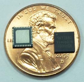
SkyTraq Technology Inc., a fabless GNSS positioning technology company, today introduced highly integrated Venus816 single-chip GPS receiver capable of supporting dual passive antenna and active antenna inputs, automatic switching from passive antenna to active antenna, and active antenna short circuit protection without needing extra external components. It offers low BOM cost for antenna-embedded GPS products needing external active antenna option.
The Venus816 includes two RF inputs with integrated antenna switching and external active-antenna current detection. A high-linearity on-chip 20dB gain 0.9dB noise figure LNA is used with one of the inputs, offering cascaded system noise figure of 1.2dB, allowing Venus816 to be used with passive antenna without the need for additional external LNA device.
The Venus816 works with GPS, QZSS, and SBAS signals, features industry leading 40Hz update rate, 29sec cold start TTFF, -148dBm cold start sensitivity, -165dBm tracking sensitivity, multipath suppression, jamming mitigation and reporting.
It is comes in 5mm x 5mm QFN40 package. A minimum of 6 external components is needed to form a working GPS receiver.
Venus816 engineering sample, evaluation kit, datasheet and reference design are available in late of October; mass production begins in November.
European Union member states began their independent testing of the Public Regulated Service (PRS) broadcast by the four Galileo navigation satellites in orbit. Transmitted on two frequency bands with enhanced protection, PRS offers a highly accurate positioning and timing service, with access strictly restricted to authorized users, such as government defense, security, and emergency services.
PRS access was initially considered for Galileo’s Full Operational Capability phase, but it has been enabled in 2013 in response to the strong interest of member states in this service. To allow early access to PRS during the current phase, the European Commission and ESA began the joint project PRS Participants To IOV (PPTI) in July 2012.
ESA ensured the availability of several tools developed under ESA contracts, including test receivers and other qualification equipment. ESA’s PRS Laboratory, based at the Agency’s ESTEC technical centre in Noordwijk, the Netherlands, provided training, demonstrations and sample data.
“Belgium, France, Italy, and the UK have now performed independent PRS acquisition and positioning tests. In parallel, ESA, through collaboration with Dutch and Italian authorities, is conducting PRS fixed and mobile validation in several locations in the Netherlands and Italy,” said Miguel Manteiga Bautista, head of ESA’s Galileo Security Office.
The PRS tests have demonstrated a current autonomous positioning accuracy of less than 10 meters when in the correct geometrical configuration. This is an impressive result considering the small number of Galileo satellites in orbit and the limited ground infrastructure so far deployed.
Italy has developed its own PRS receiver, and tests have confirmed the feasibility of independent PRS receiver development and verification based on specifications provided by ESA.
“The PPTI project is still ongoing to test more advanced functionalities this coming autumn and to run the first aeronautical PRS tests in collaboration with the Dutch authorities. Other member states have also expressed their willingness to join the IOV PRS experimentation campaigns soon,“ concluded Miguel Manteiga.
The project is a first step to ensure use of the PRS as soon as it becomes operational. It will be complemented by PRS pilot projects, focused on PRS applications, which are currently under definition in a common effort between European agencies.
The United States has submitted a request to be able to use Galileo’s PRS. Other non-EU countries have also expressed a desire to be associated with the program.
Raytheon Company reached several milestones recently in its development of the GPS Next -Generation Operational Control System (GPS OCX). Lockheed Martin’s GPS III Non-flight Satellite Testbed (GNST) — a full-sized, functional satellite prototype currently residing at Cape Canaveral Air Force Station — successfully established remote connectivity and communicated with OCX during pre-flight tests.
GNST proved that it could connect with and receive commands from Raytheon’s Launch and Check Out System (LCS), a part of OCX that supports the satellite and mitigates risks prior to launch. The GNST received commands from Lockheed Martin’s Launch and Checkout Capability (LCC) node in Newtown, Pennsylvania via the OCX servers at Raytheon’s facility in Aurora, Colorado; the system then returned satellite telemetry to the control station. The tests mirror launch and early orbit testing planned for all flight vehicles.
“While we have connected OCX with ground-based simulators before, these tests were the first time that OCX and a GPS III satellite have actually communicated,” said Keoki Jackson, vice president for Lockheed Martin’s Navigation Systems mission area.
Ahead of Schedule. Raytheon received Interim Authorization to Test (IATT) security certification from the U.S. Air Force for OCX LCS four months ahead of schedule. The company received a one-year certification with no liens, meaning the government does not require any changes.
“Typically, IATT certification is given for six-month increments,” said Matthew Gilligan, Raytheon’s GPS OCX program manager and a vice president in Raytheon’s Intelligence, Information, and Services business. “The LCS one-year accreditation speaks to the quality of the information assurance design and threat protection.” The IATT not only includes the LCS, but also Lockheed Martin’s GPS III satellite support systems, Exercise and Rehearsal Training Tool, and Upload Generation Tool.
OCX is being developed in two blocks. There are seven iterations in Block 1 and one in Block 2. LCS is the fifth Iteration of Block 1; it successfully completed Critical Design Review in June 2013.
Early Orbit Exercises. Lockheed Martin and Raytheon also completed the third of five planned launch and early orbit exercises to demonstrate launch readiness of GPS III and OCX.
Exercise 3 demonstrated space-ground communications; first acquisition and transfer orbit sequences; orbit-raising maneuver planning and execution; and basic anomaly detection and resolution capabilities. In addition, the industry and Air Force GPS Directorate teams jointly executed mission planning activities, such as orbit determination and the generation of upload command files.
Two additional readiness exercises and six 24/7 launch rehearsals are planned before launch of the first GPS III satellite. The first flight GPS III space vehicle (SV-01) is expected to be available for launch in 2014, and launched by the U.S. Air Force in 2015.
Exelis Encryptors. Exelis delivered the first three of a planned 14 ground-based encryptors to Raytheon Company for OCX. Designed to automatically code and decode GPS signals, encryptors facilitate the exchange of user information by securely transmitting navigation payload data between the OCX ground station and the orbiting constellation of satellites.
Delivery followed successful thermal, electromagnetic interference and security verification testing. Exelis provides critical elements of software in the navigation processing subsystem that will enable controllers to better understand the exact position of GPS satellites. This helps ensure accurate navigation information is securely broadcast to users. In addition to encryptors, Exelis is building high-precision receivers for use in GPS ground monitoring stations and satellite signal simulators for testing purposes.
Exelis is also on contract with Lockheed Martin to provide the payloads for the GPS III satellites.
Russian scientists and engineers are at work on a new code-division multiple-access signal format to be broadcast on a new GLONASS L3 signal. Taking an approach similar to that implemented on the newly designed GPS L5 signal, this will, once implemented across the constellation by new satellite launches, facilitate interoperability with and even eventually interchangeability among other GNSS signals, including of course GPS.
An article in the November issue of GPS World, authored by Alexander Povalyaev, the deputy head of division in JSC Russian Space Systems and a professor at the Moscow Aviation Institute, will give an outline and provide some details on a new flexible navigation message format proposed for use in the GLONASS CDMA signal under development. The format allows for relatively easy upgrades in the navigation message, if required.
Navigation messages developed and broadcast so far, by both GPS and GLONASS, are fixed, regular structures including pages (frames), subframes (rows), and words. Despite their simplicity, “such structures are very conservative indeed,” says Professor Povalyaev. The only possibility to update such navigation messages is restricted to the use of previously allocated backup frames. Increasing numbers of such frames make for ineffective use of navigation message transmission capacity. Conversely, the relatively small number of backup frames restricts the potential for future navigation message upgrades.
Prof. Povalyaev states that a comparison of data transmission via GLONASS and GPS, respectively, reveals that the data transmission rate in GLONASS is 5 times greater than in GPS. This explained by the higher redundancy of the GPS navigation message. In addition to approximately 11 percent of its subframes in backup, the GPS signal reserves fields for transmission of 32 satellite almanacs. As a result, Povalyaev believes that the GPS navigation-message transmission channel used inefficiently.
For GLONASS, the situation is different, with fewer backup bits in the navigation message, and fields reserved for transmission of only 24 satellite almanacs. This increases transmission channel efficiency but creates problems when it comes to updating the system, particularly in maintaining backward compatibility for previously manufactured user equipment. From this point of view, he says, a large number if backup frames in preferable.
He proposes a GLONASS navigation message with flexible row structure, as was used for the first time in the design of the GPS L5 signal. In this structure, the navigation message is formed as a variable row flow of different types. Each row type has a unique structure and contains specified information type, for example, ephemeris, almanacs of specific satellites, parameters of Earth pole movement models, parameters of ionospheric delay models, and so on. He goes on to describe how signal-processing disruptions in legacy user equipment can be avoided.
A flexible row structure of the navigation provides more effective use of transmission channel capacity. The main advantage of the flexible row structure is the possibility of its evolutional upgrade, meeting the requirements of backward compatibility.
Currently GLONASS uses signals with frequency separation in L1 (1592.9 – 1610 MHz) and L2 (1237.8 – 1256.8 MHz). The foreseen upgrade, already underway with one recently launched GLONASS satellite transmitting an L3 signal, will permit, in the long term, signals with code separation in L1, L2, and L3 (1190.35 – 1212.23 MHz).
Look for further details in the November issue of GPS World magazine.
IndoorAtlas announced the public launch of its geomagnetic indoor positioning service. This service opens up unprecedented possibilities for businesses in the realm of enhanced customer experience, and will be available from now through December at no cost via the company’s website: www.indooratlas.com.
According to the announcement, IndoorAtlas pioneers geomagnetic indoor positioning, which works just like GPS in places where GPS does not work. A compass in a smartphone detects magnetic field anomalies caused by steel parts within buildings that IndoorAtlas’ patented technology captures to create unique magnetic “fingerprints” for positioning. When used in a retail setting, it allows shoppers to locate products right down to the specific sections at the aisle-level.
“We are set to disrupt the retail market by finally bridging the gap between mobile and in-store experiences,” said Professor Janne Haverinen, PhD, CEO, IndoorAtlas. “Consumers are always looking for that personalized, in-the-moment shopping experience. Businesses, as such, seek the quintessential technology that can successfully converge mobile advertising with indoor positioning. They will be amazed at what this technology can do to drive engagement and increase sales.”
Nitesh Patel, director of wireless media strategies, Strategy Analytics pointed out, “IndoorAtlas’ solution is clearly distinct from current Wi-Fi- and Bluetooth-based indoor locations services. It enables venue owners to leverage existing smartphone technology without investing in Wi-Fi or Bluetooth.”
The company reports that no additional man-made infrastructure is required and that IndoorAtlas’ solution alone presents cost savings that could add up to over $100,000 per store each year. “IndoorAtlas is enabling the holy grail of location-based advertising. Its indoor positioning accuracy is exactly what the retail industry has been waiting for, for a very long time. Combined with the ensuing capital savings, the possibilities presented in the area of targeted advertising are significant,” commented Asif Khan, president of the Location Based Marketing Association.
Key benefits of IndoorAtlas include:
● Product Search: By keying in the product they are looking for, users will be able to pinpoint a product’s exact location within an establishment.
● Wayfinding: Knowing where the products are may not be enough. In this case, IndoorAtlas’ blue dot positioning shows consumers how to get to exact aisles. This feature provides astonishing accuracy level of 10 feet or less, which no other solution can do today without significant investments in infrastructures.
● Product Proximity Advertising (opt-in feature): Based on where consumers are located within an indoor space, IndoorAtlas intuitively bubbles up related deals, advertisements and recommendations on users’ smartphones or tablet screens. This empowers consumers to find the best value and products for their needs.
In a previous IndoorAtlas pilot conducted with Finnish supermarket chain Prisma early this year, the store reported an increase in sales revenue of approximately 10%, which is directly attributable to the Product Proximity Advertising feature. Businesses utilizing IndoorAtlas can expect to enjoy greater cost-savings as well as an opportunity to raise the bar for customer experience, which results in increased sales.
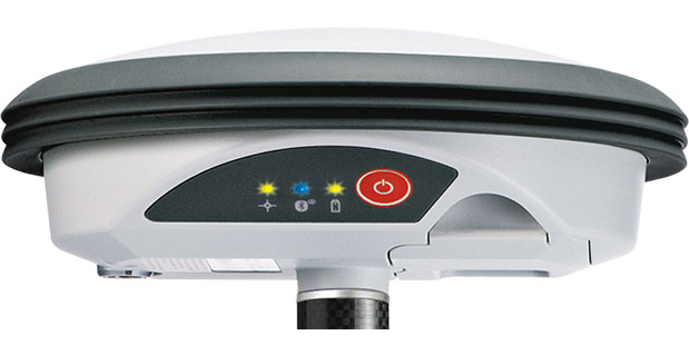
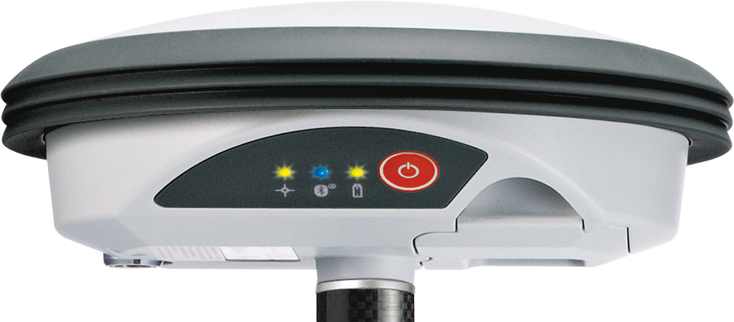
With its recent Ingress Protection (IP) certification, the Leica Zeno GG03 SmartAntenna is now an IP68-certified SmartAntenna for GIS applications. IP68 represents the top rating for protection against dust, moisture and water. Meeting the tough standards for Ingress Protection (IP) makes the Leica Zeno GG03 a rugged GNSS SmartAntenna for GIS asset collection and management tasks.
The upgradable Leica Zeno GG03 SmartAntenna is designed for organizations that require a compact and lightweight device for accurate and reliable positioning. The robust design of the Zeno GG03 brings further advantages when collecting GIS assets by offering reliable and rugged operation in extreme environments, even after continued exposure to water and dust.
“The Leica Zeno GIS series is used all over the world in the most demanding environments,” said Product Manager Johannes Hotz. “The IP68 rating further underlines the quality and robustness of the Leica Zeno GG03. The industry-leading GNSS performance and an unmatched ultra-rugged design is a big win for our customers in the field.”
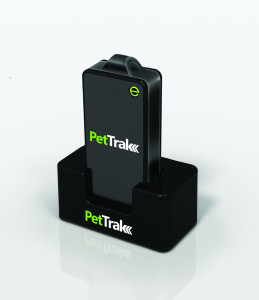
eTrak has announced the release of its latest product, the PetTrak GPS+ tracking system. Now available for purchase online, PetTrak is a small, lightweight device used to track the location of most pets.
PetTrak uses GPS+, eTrak’s patent-pending technology utilizing Wi-Fi, Cell ID, and GPS to deliver accurate location, indoors or out. Users will be able to utilize PetTrak to always know the location of their animal companions. PetTrak also allows users to set up specific safety circle zones, around designated areas where pets spend most of their time. If the pet leaves or enters this zone, the pet’s owner will be notified via text or email.
“One of the best features of PetTrak is the safety circle, which enables pet owners to draw a boundary circle around the house, yard, or any place that provides a protective perimeter for a pet,” said John Harris, eTrak founder and CEO. “If a pet wanders off beyond the circle, PetTrak will send an email and text message to the owner’s cellphone and computer. Not only that, but it will even include a Google map with the pet’s location.”
The PetTrak device can be attached to Simply attached to a pet’s collar. The animal can then be tracked in virtually any environment around the clock, from any smartphone, computer or tablet. With more than six million pets lost every year, PetTrak is designed to help owners rest assured knowing their furry friends are safe.
Esri announced it is now accepting user presentations for the 2014 Esri International User Conference, July 14–18, in San Diego, CA. Each year, the Esri UC features more than 900 user presentations ranging from technical best practices and success stories to discussions about cutting-edge research and the future of geospatial technology. Presenters can choose from more than 90 topics that cover 26 industries.
Abstract submissions are due by November 1. For more information and to submit an abstract, visit www.esri.com/uc.
According to the announcement, the fifth edition has been updated with new resources including case studies, tips, and terminology definitions that reflect the latest advances in GIS technology and information. The accompanying DVD includes examples and templates, exercises, and videos of the seminar Planning and Managing a GIS from the 2012 Esri International User Conference.
Drawing from decades of Tomlinson’s consulting experience and worldwide GIS seminars, this new edition bridges the communication gap between the senior managers who oversee information technology systems and the technical specialists who design and implement the systems. The book provides a common ground for both groups so that each clearly understands the methodology needed to implement and maintain an effective GIS.
“Successful GIS implementation depends on a well-thought-out and executed plan,” says Esri president Jack Dangermond. “If you follow the methodology presented in this book, you will be on the track to success. I hope that you find Roger Tomlinson’s work as informative and beneficial as my colleagues and I have.”
Tomlinson created the first computerized geographic information system in the 1960s while working for the Canadian government. He is a former chairman of the International Geographical Union GIS Commission, a past president of the Canadian Association of Geographers, and the second-ever recipient of the prestigious Alexander Graham Bell Award from the National Geographic Society.
A watershed moment may be approaching for the connected vehicle market. The National Highway Traffic and Safety Administration (NHTSA) is about to start on the path towards mandating connected vehicle technology. Interest in the market is not limited to a few countries; last week I moderated a GPS World webinar on the connected vehicle that drew registrants from 40 countries. Other news in the industry includes Sprint removing Sprint Navigation and TeleNav GPS Navigator from bundled data and data add-on plans. A new report shows it has become more expensive to acquire app users. And despite no longer being preinstalled on iOS devices, Google Maps is doing pretty well with Apple iOS users.
During our GPS World connected vehicle webinar, held September 19, I noticed differences in how the audience characterized the connected vehicle. The connected vehicle enables information to be exchanged with other vehicles, devices and/or road infrastructure to provide safety, mobility and consumer functionality. The devices that are used with the connected vehicle can be nomadic (phone, tablet, personal navigation devices), vehicle embedded and aftermarket devices. Communication options are currently cellular, Wi-Fi or DSRC/WAVE.
Regulation Pushing Connected Vehicle Forward. In a recent statement, the National Highway Traffic and Safety Administration (NHTSA) asserts that connected vehicle technology “can transform the nation’s surface transportation safety, mobility and environmental performance.” NHTSA is expected to start rulemaking on the connected vehicle later this year, which could result in a connected car industry mandate in the U.S. While it could take five or more years for final rules and several more years for rules to take effect, it would be a transformative event. “In six years, I expect to see vehicles widely using the technology,” said Scott McCormick of the Connected Vehicle Trade Association. “Vehicle manufacturers are eager for connectivity in vehicles, but need to understand the regulations that will be in play. This hasn’t been idle time, as vehicle makers are ahead of the game and have already embedded some connected vehicle technology into vehicles that can later be activated.”
The commercial fleet market has been the first adopter of connected vehicle technology as efficiencies provide cost savings, but the automotive market is poised to catch up. “Fleets now have access to actionable intelligence from the field,” said Andrew Maliszewski of Micronet, as well as an industry consultant. “Business decisions are now being made from data, including fuel levels, driver behaviors, vehicle performance, weather and traffic conditions, and even real-time trailer connect/disconnect events.”
Ownership of Data is Tricky. Some of the data that is produced inside a vehicle will be of great value to marketers. It will reveal personal information, including your driving habits, where you go, and how you react to in-vehicle marketing. David Jumpa of Airbiquity asserts, “There is uncertainty on who will own the data, but the sensory data, such as how you brake and accelerate, would be owned by the vehicle OEM.” When polled, many listeners of the webinar opined that content and app providers, and not vehicle OEMs or data infrastructure companies, will own personal data generated.
Making Money, or Not. The technology of the connected vehicle market hasn’t been easy, but it has been much simpler than finding the revenue models that will support companies in this market. “In the past, the vehicle market would use a tier-one manufacturer to deliver the entertainment solution, including maps and routing,” said Scott Sedlik of Inrix. “That isn’t the case now, and multiple suppliers work together and are also having to carry the risk that the vehicle OEMs had solely carried.” Some of the content and app providers are making money; others are figuring out the right business model. One of the questions that remain is whether the OEMs will pay for in-vehicle services and content. This is a pivot point of business, Sedlik adds.
Mobile App Marketing Cost at High. For brands that proactively market their apps, the cost of acquiring a loyal user increased in July to $1.80 according to Fiksu’s Cost per Loyal User Index. This is a jump of 30 cents from June, falling just a penny short of the December 2011 price of $1.81. Fiksu attributes the cost rise to brands leveraging Facebook’s mobile app ads, which target consumers based on app and games access on smartphones.
Mobile Map Usage. More than 60 percent of iOS users accessed Apple Maps at least once during the previous 30 days, reports Mobidia. That isn’t too surprising given that it comes installed on the phone. However, 20 percent of iOS users accessed Google Maps during the same period — impressive, since the user has to go to the effort of installing the software. Google Maps usage is heavy, although not as heavy as Apple Maps use. 55 percent of iOS users that use Google Maps, use it weekly; 80 percent of Apple Maps users use it weekly. Not bad, Google.
In the wake of Microsoft’s recent purchase of Nokia’s mobile phone business, the Nokia unit formerly known as Navteq, and now know as HERE, has opportunities, but also a hard-to-guess future. At least one industry analyst believes that Navteq/HERE was not included in the Microsoft deal because it was too expensive.
“While much ado has been made of the Nokia/Microsoft deal in the press, I was interested in why Mr. Softy did not acquire Navteq/HERE with the other assets of interest. There are several possibilities to explain this omission,” said Mike Dobson, TeleMapics president. “First, it could be the case that Nokia did not want to sell Navteq/HERE. Second, it is possible that Microsoft had no interest in acquiring its current map database supplier. Third, maybe the price for Navteq/HERE was too high. My vote is for number three.”
Dobson said that Nokia clearly would like to sell HERE, as it does not fit with the company’s profile, growth strategies, or competencies, on a going-forward basis. “Just as Navteq was not a good fit for Nokia in 2007, it is now a less comfortable fit for the reconstituted company, which is being focused on network infrastructure services,” he said. “Conversely, I suspect Microsoft was ambivalent about a deal that included [Navteq/HERE].” Under the proposed Nokia/Microsoft deal, Nokia’s mapping assets are to be licensed for a four-year term by Microsoft, which gives them time to firm up their future strategy for spatial data. Note that the price of the license for the mapping products was not part of the $7.1 billion transaction, Dobson said.
“Why was Mr. Softy gun shy? First, I suspect that Microsoft concluded that owning a mapping company was not core to any of Microsoft’s current initiatives, including its bumbling approach to location and connected car services,” Dobson said. “Next, Microsoft has enough problems competing with companies in its distribution chain, without adding another business that would serve to complicate its relationship with manufacturers and resellers. Of course, all of these objections could have been overcome if the price was right, it wasn’t, but that does not mean it won’t be in the future.”
Where Does Navteq Go from HERE?
Dobson says Navteq, Nokia and HERE are in a world of pain. “While the ‘new’ Nokia will have the ability to fund all of the development to enhance the Navteq database that it has deferred over the past five years, I think it is unlikely to do so. Nokia does not appear to understand the fundamentals of the location market, the automotive navigation market, or the connected car market,” Dobson said. “Perhaps most importantly, they have lagged Google in evolving their map compilation process into a modern, synergistic, information sourcing engine. The Navteq approach to crowdsourcing hinders their potential speed to market with updated map information and has allowed Google to reach parity with Navteq in some areas, while exceeding it in quality in other markets.”
The future battleground in the location markets will devolve into a scarp for ownership of the last mile, Dobson said. “The type of thinking that believes that the ‘last mile’ is all about road geometry, simply does not understand the problem. People want to know that the map will support their journey to a destination, but they are focused on the destination and the various opportunities that it presents,” he said. “For example, the mobile phone has promoted an egocentric view of the world focused on ‘what’s around me?’ Providing the spatial detail of the total environment that surrounds the user is key to winning the last mile battle and I do not see Nokia having the assets to participate in this market.”
Nokia announced that HERE, at the recent Frankfurt Motor Show, partnered with Mercedes Benz, Continental Corporation and Magneti Marelli to offer connected products and services beyond navigation. Nokia believes that connecting the car to the cloud is one of the biggest opportunities for the automotive industry.
“Whether the concept of the connected car offers Nokia a lifeline is unclear. Connectivity may suck the spatial data out of the car and into phone based systems,” Dobson said. “Others would argue that smart cars will require a detailed, highly accurate database of spatial information to manage the safety systems in the automobile of the future. I’m not wise enough to predict the future, but I think the Nokia is going to have a rocky road with Navteq/HERE.”
Dobson said that it is interesting that Microsoft has loaned Nokia 1.5 billion Euros in three tranches of convertible bonds. “The bonds will be redeemed and netted against the deal proceeds, although the loan is not conditional on the deal closing, nor is Nokia obligated to exercise its option,” he said. “However, it would appear that Mr. Softy and Nokia are not quite through with each other: if Nokia exercises these options, Microsoft will become a shareholder in Nokia.”
Millennial Media has announced the launch of Omni Measurement Solutions, a suite of measurement products designed to evaluate and demonstrate the effectiveness of mobile campaigns. The new solutions will combine Millennial Media’s extensive first-party data with best-in-class third-party data sources to show the impact on key advertiser metrics driven by a campaign.
“Measurement is one of the most important issues in mobile advertising today,” said Mollie Spilman of Millennial Media. “Brands need to feel confident that the dollars they are spending in mobile advertising are truly moving the needle, and our Omni Measurement Solutions represent the most comprehensive, data rich solution at this scale in mobile advertising.”
Omni Measurement Solutions currently consists of the following products:
Door Open Rate – Measures the impact on foot traffic to a given retail location generated by a mobile campaign.
Register Ring Rate –Measures the impact in total credit card spend at a retail location due to a mobile campaign, including number of transactions per purchaser and total basket size.
Brand Lift Rate – Measures the impact on high funnel activities such as awareness, intent, consideration, and recall.
For every measurement product in the Omni Measurement Solutions suite, Millennial Media partners with a third party, and matches mobile IDs against exposed and control groups to judge the effectiveness of marketing campaigns with target audiences. Data analytics company Neustar and location analytics firm Placed are among the launch partners. Millennial Media will offer end-of-campaign reports that will accurately show the impact on advertiser KPIs, and give advertisers credible and qualified insights to use for future marketing efforts.
To power Door Open Rate, Millennial Media selected Placed. “The product we’re working on with Millennial Media allows advertisers to track conversions beyond the mobile device itself, and extend measurement into the physical world,” said David Shim of Placed. “By combining Placed Attribution with Millennial Media’s industry leading scale, we’re able to measure the impact on in-store visits in a way that was simply not possible before.”
Additional products will be added to the suite in the coming weeks, including a product in collaboration with comScore that measures online consumer behavior after mobile ad exposure.