Blue Marble Geographics announces the release of Global Mapper version 15. This major release includes many powerful updates along with a new extension interface that provides add-on functionality capabilities including the COAST tool and a new LiDAR Module. Blue Marble’s geospatial data manipulation, visualization and conversion solutions are used worldwide by thousands of GIS analysts at software, oil and gas, mining, civil engineering, surveying, and technology companies, as well as governmental and university organizations.
According to the announcement, the new extension interface in Global Mapper 15 allows third parties and customers the opportunity to create add-on applications that can be part of the software with access to all the formats and tools that Global Mapper has to offer. As part of this release, Blue Marble has created three modules; The COAST tool for cost/benefit analysis of coastal flooding incidents, an Overview Map Window application, and a new powerful LiDAR module. The LiDAR module is available for the price of another seat of the software, while COAST and the Overview Application are free. Other new extension modules from key partners are expected over the next year.
This release also features a new Mathematical Raster Calculator for multi-band imagery analysis, the ability to edit and re-calculate multiple view shed layers, 3D PDF read/write support, scripting enhancements, such as passing variables to the script from the command line, and much more. The LiDAR Module is a powerful toolbar that has totally new functionality on par with software that is many thousands of dollars more expensive. Leveraged through a toolbar for easier management and editing capabilities, the module features the ability to view, edit and reclassify points in the Path Profile viewer, robust gridding techniques for faster, extremely flexible creation of elevation surfaces, including smart decimation through binning, and other techniques. The tool also allows for automatic classification of ground points from unclassified point clouds, and support for reporting LiDAR statistics via script to a text file to facilitate QA processes and new format support for E57 LiDAR.
“Global Mapper is TRULY the GIS tool for everyone and that includes the basic user who simply needs to view data or output it to Google Earth, as well as the highly trained GIS or Survey professional working with LiDAR point clouds of a billion points or more,” stated Blue Marble’s President Patrick Cunningham “We are committed to adding the most advanced functionality at a price point that is within reach of everyone and we have again done so with this release.”
Sponsored by:Hemisphere GNSS
Original Broadcast Date: Thursday, September 19, 2013 Moderator: Janice Partyka, Wireless LBS Insider editor Speakers: David Jumpa, Chief Revenue Officer, Airbiquity;Scott McCormick, President, Connected Vehicle Trade Association; Andrew Maliszewski, Executive VP, Micronet;Scott Sedlik, VP Product and Marketing, Inrix Summary: The biggest announcements and the most interesting news at the three big wireless/electronics shows in 2013 have all concerned the connected car. Location is a core technology. How will the connected vehicle market evolve? Will there be similarities to the more advanced fleet market? Providers of navigation, mapping, traffic, middleware, search, points of interest and mobile advertising all have key roles to play. How will the complexity of personalization and extras make it difficult to deliver products and service? The pace will only accelerate. Sort through the multiple issues and get your roadmap to the future with Janice Partyka and a panel of industry experts.
JAVAD GNSS has launched a new version of the TRIUMPH GNSS receiver, which features 864 channels — more than any receiver it has yet offered. The TRIUMPH-LS land survey receiver offers, in addition to the 864 GNSS channels, three powerful processors, 256 I/O, 24 digital filters, 24 anti-jam filters and 14-MB program memory all in a single chip, which uses less power and makes the total system less expensive, according to the company.
The announcement was made at the ION GNSS+ Conference, being held this week in Nashville, Tennessee.
Javad Ashjaee, CEO and founder, explained the decision to incorporate 864 channels. “Some questioned the need for the 216 channels. They now realize the need for 440 channels. We assign multiple channels to each satellite for redundancy and reliability. We use more than 100 channels to scan GNSS bands for interference — 864 channels is the key to reliable performance.”
The TRIUMPH-LS provides visual stake-out, six parallel RTK engines, more than 3,000 coordinate conversions, advanced coordinate geometry features, and rich attribute tagging on a high-resolution 800 x 480 pixel display. When used in photogrammetry, offsets can be calculated using the internal camera for 10-centimeter accuracy, or an external camera for 5-centimenter accuracy. TRIUMPH-LS is the first JAVAD GNSS receiver to offer photogrammetry for land survey.
Other features include versatile attribute tagging, feature coding, automatic photo and voice documentation, and an interference monitoring and reporting feature.
The TRIUMPH-LS has a battery life of 25 hours in RTK rover mode with full screen brightness and UHF/GSM. Two hours of charge equals two days of surveying. The internal batteries are field serviceable and can be easily replaced by the user when needed.
The TRIUMPH-LS, including batteries and pole, is the lightest GNSS RTK receiver in its class, according to JAVAD GNSS. The total weight of the system — including radio, controller, pole and 25 hours of internal battery — is 2.5 kilograms.
Built on a tough magnesium alloy chassis, all connectors, SIM cards, and micro-SD cards are protected against harsh environmental conditions. The pole can be collapsed and the unit can easily fit in a car seat — there are no long poles and no separate controller or brackets to disassemble.
The TRIUMPH-LS automatically updates all firmware when connected to the Internet via Wi-Fi. The built-in GNSS full tracking antenna has a large ground place and excellent centering and rotational performance.
To learn more about the TRIUMPH-LS, stop by the JAVAD GNSS booth (Booth D) in the ION GNSS+ Exhibit Hall now through Friday.Presentation will be given Thursday at the conference room of the exhibition hall at 2:00 pm.
The collaborative solution will be launched commercially later in 2013, and was previewed at ION GNSS+ in September in Nashville, Tennessee.
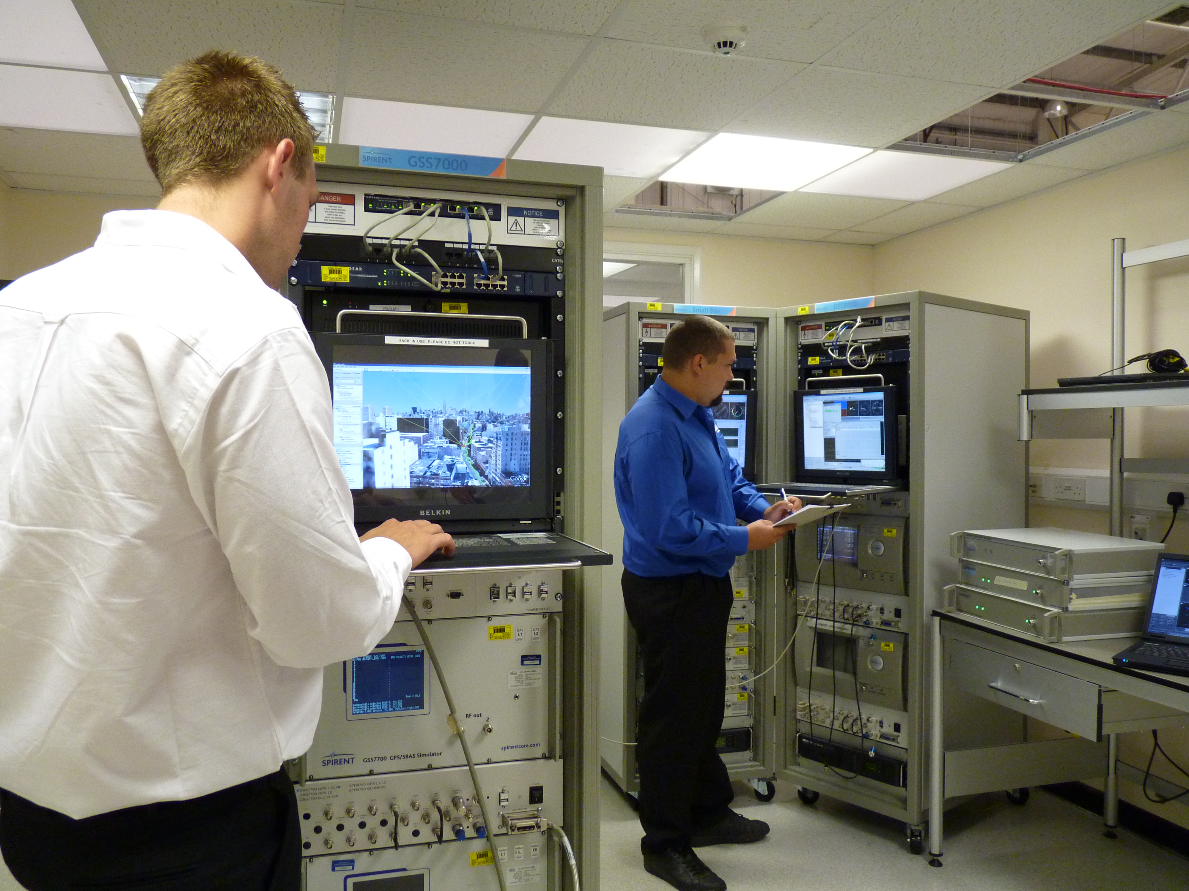
The test bed will concurrently simulate legitimate GNSS constellations and spoofed or hoax signals. It will enable positioning systems manufacturers to improve their products’ resilience to hoax signals.
As GNSS becomes increasingly embedded in modern infrastructure for application timing and device positioning, the impact of spoofing attacks becomes greater. From mobile telephony to Internet banking, GNSS timing signals are used in many key systems, and yet there is no requirement on GNSS equipment to demonstrate any degree of robustness to block or even detect malicious attacks that disrupt performance.
“There is growing industry concern about the vulnerability of satellite navigation signals,” said John Pottle, Marketing Director of Spirent’s Positioning Division. “This will help the industry to create positioning systems that are more resilient to interference.”
Hoax or spoofing attacks work by mimicking genuine GNSS signals, which mislead GNSS receivers. Often affected receivers do not recognize when they are receiving fake signals and continue to operate normally, but provide false time or position information. This new test tool helps to develop systems that will detect and counter spoofing attacks by providing a fully controllable laboratory based, non-radiated test solution to evaluate a receiver’s response to a range of spoofing attacks. The test tool controls the emulation of signals representing both the genuine GNSS signals and the false signals. This allows users to simulate a wide range of sophisticated attacks and monitor the response of the receiver under attack to then improve the resilience of the design against such attacks.
For more information on threat detection and mitigation testing visit Spirent Booth #F during ION GNSS+, September 15-20 in Nashville, Tennessee.
Trimble today introduced the Trimble BD930 module as part of its GNSS OEM portfolio. This small module features triple-frequency support for GPS and GLONASS plus dual-frequency support for BeiDou and Galileo constellations. Capable of receiving a wide range of commercially available GNSS signals, the 220-channel BD930 takes advantage of all available signals to provide optimal and reliable RTK centimeter positioning.
The announcement was made today at ION GNSS 2013 Conference and Exhibition.
“The OEM and system integrator communities trust Trimble to supply high performance, accurate and reliability positioning solutions for their systems,” said Ed Norse, portfolio manager of Trimble’s GNSS OEM modules. “The Trimble BD930 delivers the latest GNSS technology in an easy-to-integrate form factor for demanding conditions and applications such as high-precision navigation and control, robotics and lightweight unmanned vehicles.”
The triple-frequency Trimble BD930 (measuring 41 x 51 millmeters) is a small, yet powerful GNSS module specifically designed for applications requiring high accuracy in a compact package. Form-Fit-Function compatible with the Trimble BD920 receiver, the module tracks all available GNSS constellations including GPS, GLONASS, Galileo and BeiDou.
The BD930 is designed for all levels of accuracy with an advanced engine that provides GNSS, DGNSS and RTK positioning in challenging environments such as under tree canopy and urban canyons. The BD930 allows for easy integration and rugged dependability. Flexible connectivity options — Ethernet, RS232 or USB — provide fast data transfer and easy configuration via standard Web browsers. External 10 MHz frequency input is supported for advanced applications.
The Trimble BD930 module is expected to be available in the fourth quarter of 2013 through the Trimble Precision GNSS + Inertial worldwide sales channel.
Signal Sentry 1000, an Exelis product that detects and locates GPS interference sources in 3-D by using longitude, latitude and altitude has demonstrated successful results during a planned field testing event held last week at the Vidsel Test Range in Sweden.
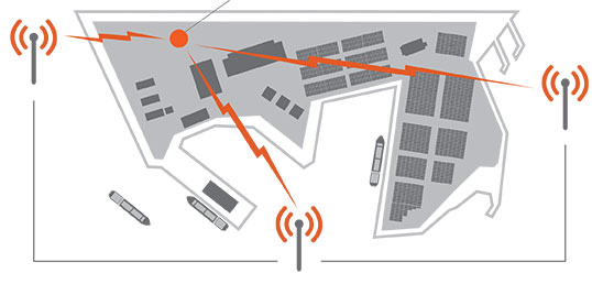
Taking advantage of the range’s remote location, Exelis was able to conduct tests of its Signal Sentry 1000 product using controlled jamming. The test was conducted without disrupting the GPS signal relied upon by civilian and military operations outside of the test range location. The test employed eight sensors positioned in an array pattern and showed that Signal Sentry was able to successfully detect and locate the jamming source. Having demonstrating interference detection and location capability, Signal Sentry 1000 can be deployed to collect actionable intelligence for law enforcement and protect GPS signal-dependent critical infrastructures.
Signal Sentry 1000 technology is a network of threat-detection sensors, which is part of a centralized server executing Exelis-developed proprietary location algorithms. These sensors can be strategically located around different types of critical infrastructure, such as shipping ports, utilities and government facilities to automatically sense and locate any intentional or unintentional GPS jamming source. Should a threat be detected, users would receive location information and actionable intelligence in order to determine an interference-mitigation plan.
“Exelis developed Signal Sentry 1000 to help protect critical infrastructure and to deliver intelligence to law enforcement operations that depend upon GPS availability,” said Mark Pisani, vice president and general manager of precision instruments and positioning, navigation and timing for Exelis Geospatial Systems. “Achieving this field test milestone proves that our detection technology works. The next step is to evolve this technology for our military customers.”
Signal Sentry 1000 builds upon Exelis expertise in the field of GPS and positioning, navigation and timing. Exelis payloads and payload components have been on board every GPS satellite for nearly 40 years. Today, Exelis is involved in GPS modernization initiatives, building tomorrow’s GPS III satellite constellation by developing and integrating the navigation payloads. Exelis is also providing navigation processing components, precision monitor station receivers, and key components of the system security design for the GPS Operational Control System, known as OCX.
Rx Networks, Inc., a mobile location technology and services company, today announced a new z-axis determination capability called Zed. This new solution, comprised of a client software library and associated cloud-based data services, is targeted at chipset vendors, device OEMs and application developers seeking to integrate reliable floor-level detection. The announcement came at ION GNSS 2013 in Nashville, Tennessee.
Whether for emergency or consumer applications, the determination of a mobile device’s vertical position while indoors presents unique challenges. Given the environment, even when a GNSS receiver attains a fix, a mobile device cannot reliably use the reported altitude. Beacon-based techniques, such as those derived from Wi-Fi or Bluetooth, remain challenging as they often rely on GNSS-based crowd sourcing or costly venue characterization. The built-in barometric pressure sensors in recent smartphones bring a new ability to estimate altitude, but they have unique and variable characteristics that prevent floor-level accuracy without further assistance.
Rx Networks’ new Zed solution combines accurate geo-reference barometric pressure data (from Custom Weather, a global provider of real-time weather information), automatic device characterization, and pressure crowdsourcing along with existing location services to determine a device’s altitude within 1 to 3 meters.
The Zed solution will be commercially available at the start of 2014 and will be available either on its own, or as an optional feature alongside Rx Networks’ GPStream Assisted-GNSS and XYBRID hybrid location solutions.
For more information a demonstration of Zed, visit Rx Networks booth at ION GNSS+ 2013.
Rx Networks, Inc., a mobile location technology and services company, today announced that it is upgrading its GPStream GRN (Global Reference Network) to include support for the BeiDou and Galileo constellations alongside its GPS and GLONASS assistance services. The upgrade will be completed by the end of this year with commercial service starting in 2014. The announcement came at ION GNSS 2013 in Nashville, Tennessee.
With the official release of the Chinese BeiDou specifications in late 2012 and the rollout plans for Galileo, several semiconductor vendors will soon be introducing chipsets capable of supporting these new GNSS constellations. Multi-constellation devices receiving GNSS assistance data from GPStream GRN will have much greater success in areas where satellite visibility is severely limited, such as urban canyons or indoors, the company said.
GPStream GRN is the foundation on which Rx Networks’ and third-party real-time and predictive Assisted-GNSS products operate, as used by more than 700 million smartphones worldwide. Backed by a 99.999% Service Level Agreement, GPStream GRN is already a proven source of real-time assistance data for most North American mobile operators for their E911 location platforms.
“Our reference network will be the first to commercially support all four constellations,” said Ryan Reilly, Product Manager, “reaffirming our leadership position on Assisted GNSS solutions for the mobile market.”
For more information, visit the Rx Networks booth at ION GNSS+ 2013.
The preview version of Trimble’s CenterPoint RTX post-processing service, enabling GNSS observations using available Galileo and BeiDou MEO satellites.
Trimble announced today a Preview version of its CenterPoint RTX post-processing service, enabling GNSS observations using available Galileo and BeiDou Middle Earth Orbit (MEO) satellites. Powered by Trimble RTX technology, the free CenterPoint RTX post-processing service provides better than centimeter level positions.
The announcement was made today at ION GNSS 2013 Conference and Exhibition.
The existing CenterPoint RTX post-processing site uses data from the GPS, GLONASS, and QZSS satellite systems. Through a link accessible from the post-processing website, users can enter a Preview site and derive positions that also use data from available open service Galileo and BeiDou MEO satellites.
“With the addition of Galileo and BeiDou MEO support, we offer researchers, scientists and academics the opportunity to evaluate and experiment with results from these evolving satellite constellations,” said Patricia Boothe, general manager of Trimble’s Positioning Services Division. “We are committed to continuing to advance CenterPoint RTX post-processing and the underlying Trimble RTX technology to enable ever higher accuracy positioning solutions.”
Trimble CenterPoint RTX post-processing is a cloud-based service accessed through www.TrimbleRTX.com. Users around the globe can upload static GNSS observation data and receive positioning corrections calculated in the well-defined International Terrestrial Reference System (ITRF) 2008 reference frame. The post-processed solution can be transformed to a variety of regional reference frames by selecting a coordinate system and tectonic plate.
Rockwell Collins has received a 2 million contract from the Air Force Research Laboratory (AFRL) to develop and demonstrate a secure software-defined radio (SDR) GNSS receiver capability.
GNSS typically refers to equipment that can receive signals from multiple navigation satellite systems including GPS, GLONASS, Galileo, and the Chinese BeiDou system. By utilizing multiple available satellite signals, a GNSS receiver can provide improved navigation performance and signal availability.
Hosted in a software-defined radio, this AFRL program will develop the security architecture required for the receiver equipment certifications. The arrival of modernized GPS signals and other constellations is changing the way the U.S. military accomplishes GNSS-based positioning, navigation and timing.
“Rockwell Collins is actively researching GNSS capability as it applies to the U.S. and global customer base,” said John Borghese, vice president of the Rockwell Collins Advanced Technology Center. “We’re leveraging decades of GPS experience and leading edge security architectures to produce a navigation receiver that will meet global needs.”
PCTEL, Inc. announced the launch of its next generation multi-band GNSS antennas for global timing and precision tracking applications at the ION GNSS Conference being held this week in Nashville, Tennessee.
The new antennas, which are designed for use with GPS, GLONASS, BeiDou, and Galileo systems, are being showcased along with other PCTEL antennas at the PCTEL booth in the Exhibit Hall, Booth 318/320. All models of the new antennas are available for sale.
Equipment providers for carrier network timing, precision agriculture, and global asset tracking applications need a single antenna solution for global deployment. PCTEL’s new GNSS1-TMG-26N and GPS-LB12GL-MAG antennas address global compatibility issues for two of the industry’s most crucial applications.
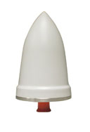
For critical timing applications for macro and small cell deployments, PCTEL has developed the GNSS1-TMG-26N antenna. The GNSS1-TMG-26N is a fixed mount network timing antenna covering GPS, GLONASS, Beidou, and Galileo system frequencies in one single unit, making it a true global solution.
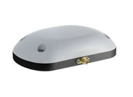
PCTEL’s GPS-LB12GL-MAG antenna is designed for precision agriculture.
For global precision navigation applications, PCTEL has developed the GPS-LB12GL-MAG to cover GPS L1, GPS L2, GLONASS, and L-BAND constellations. The GPS-LB12GL-MAG’s multi-band coverage addresses the precision market in the USA as well as differential correction signals needed across Europe and Asia.
“PCTEL will meet the GNSS market requirements for our global customers while maintaining PCTEL’s high standards for quality and performance,” said Jeff Miller, president of PCTEL Connected Solutions. “We understand that our products need global compatibility to support our customers around the world. We are proud to showcase our design excellence in this highly technical area,” added Miller.
GPS World contributing editor Eric Gakstatter gave a talk on predicted ephemeris at the Civil GPS Service Interface Committee (CGSIC) on Tuesday. The talk was invited and the topic was suggested by CGSIC coordinators. The 53rd meeting of the CGSIC was held Monday and Tuesday before the Institute of Navigation GNSS+ 2013 Conference. Here is Eric’s talk:
Whenever I point a critical finger at the GPS folks, I apologize before I do so because it’s really a wonderful system.
What I try to offer the community in general is a link between the GPS system operators and the civil community. It’s amazing when you think about it, two huge user bases of civil and military users, and a little strip called CGSIC that communicates between them. Rick [Hamilton of CGSIC] introduced me to this concept a couple months ago and asked me to investigate it and think about it. This is what I researched and talked to some folks and came up with.
First, I want to introduce you to some folks doing fascinating things with GPS.
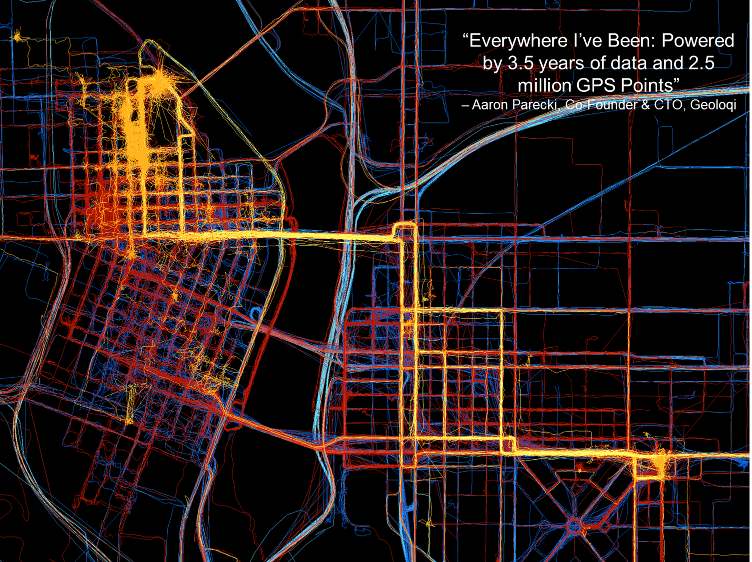
Here’s a young company, Geoloqi, doing really interesting things in Portland. They don’t have any clue where GPS came from; they just have it on their smartphones. One of the founders collected GPS data everywhere he went for the last three and a half years. This map shows 2.5 million data points, and I think it’s fascinating.
This map of Portland by Geoloqi has 2.5 million data points.
These folks interface between the GPS chipset in the mobile device and the apps that run on it. They sold their company to Esri last year.
“Geolocation has the potential to become an indispensable part of our lives. But to be a valuable service, the technology needs to be invisible yet opted into, private, and secure.” — Amber Case, Geoloqi founder
These kids just want to get things done, create ideas and create products: things like, check into a hotel when you get within 100 yards of the door; get your prescription prepared and ready for you when you come within a certain distance of a pharmacy. All these kinds of things are based on the geotrigger or geofence concept.
Now, talking about my work, primarily in surveying and mapping, with companies like utilities with 15 million customers and a lot of infrastructure. To put that at the fingertips of a maintenance person, that’s pretty amazing. I’ve been swimming in this soup for a long time, and I hadn’t heard of this concept — the predicted ephemeris (PRED) produced by GPSOC.
Take a PRED state vector data file, which is currently generated every 15 minutes by the GPS Operations Center under For Official Use Only (FOUO), currently designated unclassified, but not accessible to the general public. If it were made available for public use, it could decrease time to first fix from 40 seconds when you turn on your mobile device, to 5 to 10 seconds.
In the high-precision field like mine, surveying, it really doesn’t make too much difference because by the time you get out of your truck and set up your gear, 30 seconds has already gone by and it doesn’t make much difference.
Now it could be more of an issue with mobile devices in GPS-impaired environments such as urban canyons or indoor environments, where 30 seconds could make the difference between getting a fix or not.
If predicted ephemeris were available, developers could distribute it terrestrially via a wireless network to mobile devices.
Problem: How to transfer PRED from a U.S. government FOUO environment to make it available to application developers?
To me as a product developer or a product manager, interested in pushing products out to the community, that’s a really small speed bump. But when I talk to colleagues who operate in that (government) space, that’s a significant undertaking, a real obstacle. We’re talking about a big change, and a big process to go through to effect that change.
PRED from the horse’s mouth, so to speak, from the U.S. Air Force, really builds credibility. I can build it into a product, because I know it’s going to be there three or four or more years from now.
PRED can be made available, but Civil GPS app developers need to speak up — because civil users won’t. They don’t know about it. They don’t know what is possible.
“How does somebody know what they want if they haven’t even seen it?” — Steve Jobs
I’m trying to raise awareness here. I’ll probably write about soon in the magazine or in my [Survey Scene] email newsletter.
Frank van Diggelen, Broadcom. We’ve been doing this in the commercial world for over a decade. You all have it in your cellphones, with about 90% likelihood provided by Broadcom or someone who’s licensed our patents. It doesn’t work properly unless you have the source of the data and the client side working very cooperatively. The issue is the . . . gap between prediction and use. If the satellite is moved (in orbit or clock) then the prediction is wrong, and you need client-side software that is design cooperatively with the predictions. Our predictions are available in 2-, 4-, 7- or 30- day intervals. Think of a use case where you get a seven-day prediction, and then go away from network coverage for several days, meanwhile, say on Day 4, a satellite is moved or has its clock adjusted, on Day 5 it is set healthy, on Day 6 you turn on your handset and use the prediction from six days ago — it will be wrong and your client-side software has to catch that and know know how to invalidate the predictions.
We deliver these orbital predictions at about the rate of a billion per month. It’s been there for 10 years, and its been working so well most people aren’t even aware that it’s there. If the Air Force puts these out, that sounds great, but if you don’t have client-side software looking for erroneous predicitions — when a satellite is adjusted or moved — then things would be a lot worse for the user community than they have for the last 10 years.
Eric Gakstatter: I understand that, but that’s true for any technology. If a company implements it incorrectly, the market will reject it. Let the market decide.
There may be a need for a non-proprietary solution (PRED) that is publicly available so it could be implemented by other developers, and level the playing field to increase market adoption of GPS.