Blog

  • When Am I?: The Importance of Time in Navigation

    A few months ago, many of you may remember that I wrote about an encounter with a rather well-known female journalist who, after listening to one of my GPS presentations, said something like this, “I came here today to learn more about GPS and so far all you have talked about is atomic reference systems…what the heck do those *&@# atomic clocks have to do with GPS…?”

    I mentioned at the time how incredulous I was at the question, but that I answered it with a straight face. Now, while professional courtesy prevents me from ever revealing the name of the female journalist, I will say that she evidently started an uncomfortable trend. Much of my correspondence lately has concerned the connections between time and position and/or navigation and why we are so concerned about time.

    I won’t bore my more sophisticated readers with GPS 101, or certainly not Time and Frequency Metrology 101, but I will tell you that I think we (this is not the royal “we” but includes all of us who work with and promote GPS on a daily basis) need to do a better job describing just how GPS works and more importantly how critical precise time and frequency is to position and navigation solutions, whether GPS is utilized or not. And I don’t have the time here to take up the argument concerning how important GPS is to our critical national infrastructure. Indeed, a topic and column for another time.

    I am sure my time and frequency metrology friends and colleagues at NIST (National Institute of Standards and Technology in Boulder, Colorado) and USNO (U.S. Naval Observatory — read as UTC — home of Coordinated Universal Time and the Master Clock) would probably go about this differently. They tend to approach these problems strictly from a metrology viewpoint. While there is nothing wrong with that perspective, I hope to give you a more hands-on operational view of time and how it relates to position and navigation.

    Smithsonian Institution and Time Exhibit

    An operational backup of a Transit 5-A satellite.
    An operational backup of a Transit 5-A satellite.

    Of course, I could take the easy way out and advise all my readers to visit the latest Smithsonian time exhibit entitled: Time and Navigation – The Untold Story of Getting From Here to There. The new exhibit opens in April.

    Here are a few quick Smithsonian facts, with commentary added, for those who want to visit and learn just what time has to do with GPS and navigation in general:

    What: The Relationship Between Time and Navigation

    When: Opens in April 2013.

    Where: The Smithsonian’s National Air and Space Museum, Independence Avenue at Sixth Street, S.W., Washington, D.C.

    Responsibility: “Time and Navigation — The Untold Story of Getting From Here to There” is being produced jointly by the Smithsonian’s National Air and Space Museum and the National Museum of American History. This is one of the few times, if not the first, that two museums have jointly produced a major exhibit of this importance.

    Sponsors: The exhibition is made possible through the generous contributions of Northrop Grumman; Exelis Inc.; Honeywell; National Geospatial-Intelligence Agency; U.S. Department of Transportation; Magellan; National Coordination Office for Space-Based Positioning, Navigation and Timing; Rockwell Collins; and ION the Institute of Navigation. Note: The sponsors are listed in order of the amount they gave to present the exhibition, but it should be noted that ION was among the first contributors, making the museums’ decision to go ahead with the exhibit a more comfortable one. More on that and why it is significant later.

    The USS Alabama.
    The USS Alabama.

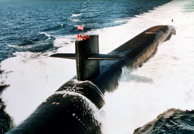
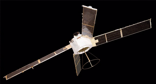
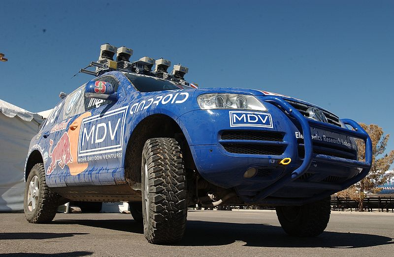
    Artifacts: (Don’t you just love the word artifact? Indeed, someone once told me, and not unkindly, that I resemble that word.) The time exhibition features 144 artifacts, drawn primarily from the collections of the participating museums. Highlights of the exhibition include a representation of a 19th-century ship from the U.S. Exploring Expedition; the first sea-going marine chronometer made in the United States; the submarine navigation system for the USS Alabama; a TRANSIT navigation satellite (a major naval predecessor to GPS); Wiley Post’s airplane, the Winnie Mae; and Stanley, originally from the Stanford University Racing Team and written about many times by yours truly in GPS World. Stanley is a robotic vehicle that can drive itself. Stanley is a 2005 Volkswagen Touareg, which has been considerably modified to navigate without remote control and without a human driver onboard. Stanley handily won the 2005 DARPA Grand Challenge (Defense Advanced Research Projects Agency), a robotic vehicle race. Stanley successfully navigated 212 kilometers (132 miles) across desert terrain and has had his (here we go, anthropomorphizing automobiles) own robotic exhibit at the Smithsonian since 2009.

    An official DARPA photograph of Stanley at the 2005 DARPA Grand Challenge. Stanley, created by the Stanford University Racing Team, won the race.
    An official DARPA photograph of Stanley at the 2005 DARPA Grand Challenge. Stanley, created by the Stanford University Racing Team, won the race.

    Organization: The current time exhibition is organized into five sections: Navigation for Everyone; Navigating at Sea; Navigating in the Air; Navigating in Space; and Inventing Satellite Navigation.

    Theme: If you want to know where you are, you need an accurate clock. In other words, you need to know when you are. About 250 years ago, sailors first used accurate clocks, later known as chronometers, to navigate the oceans. Today, we locate ourselves on the globe with synchronized atomic clocks in orbiting satellites (GPS is the primary method today). Among the many challenges facing navigation from then to now, one stands out: keeping accurate time.

    For centuries, nations have invested enormous resources to determine time and place for geopolitical reasons, and their research has changed people’s view of the world. Advanced technology that was once available only to the military has become commonplace and downloadable to cell phones, iPADS and computers. Instead of unfolding a map or stopping at a gas station to ask for directions, drivers can now consult their car’s GPS (Global Positioning) system. The new gallery examines the cultural and technological history of precise timekeeping and navigation at sea, in the air, and in space and the impact of satellite navigation on our everyday lives. Which of course are also the missions of the Institute of Navigation and GPS World magazine.

    When Am I?

    Many of you have heard the old saw about those who don’t know history being doomed to repeat it, and if you don’t know where you have been, how can you know where you are? There are probably numerous maxims that fit the bill when it comes to the history of time and navigation, and the Smithsonian Exhibit certainly does a great job of hitting all the high points, but beyond that, they will take you into about as much detail as you can stand. If possible, plan on attending the exhibit several times and delving into each of the five major themes. But if you can’t visit Washington, D.C., and the Smithsonian exhibit, then visit virtually on their excellent website.

    For our purposes, suffice it to say that you can’t really know where you are unless you know when you are. That requires a clock, the more precise the better, and consequently the more accurate your position.

    History Lesson

    More than 200 years ago, sailors sailing between Europe and the New World knew where they were only in relationship to their latitude, but had no idea other than dead reckoning of their longitude.

    Enter Boston clockmaker William Cranch Bond who, although he was not the first, constructed a specialized timepiece, which later became known as the Bond Chronometer, which sailors used to determine longitude at sea. But still there were problems. Sailors used a maritime sextant and chronometer to determine position, but both devices depended on the other. On cloudy or foggy days, either the horizon or the sun and stars or both were unavailable, and positioning/navigation was relegated to, in all seriousness, dead reckoning with a dubious magnetic compass, a rock and a rope. The problem being, of course, that dead reckoning made many mariners resemble the first word in that very unfortunate navigational phrase.

    Time and Air Navigation

    Fast forward almost a century (1903), and aeroplanes are now on the scene along with all the problems attendant in navigating a machine easily traveling ten times faster than most ships. But of course the U.S. Navy rationalized that if a watch and a sextant were good enough for navigating maritime ships, then they were good enough for ships of the air — even if the horizon was often obscured or moved around a great deal, or turbulence made balancing a sextant difficult.

    The result was most aviators gave up on the sextant, especially solo aviators, and just used a watch and, you guessed it, dead reckoning, which is exactly what happened to many aviators in 1927 who attempted to win the Raymond Orteig $25,000 prize for being the first solo aviator to cross the Atlantic nonstop from the East Coast of the U.S. — in fact, it had to be New York to Paris, France. For you trivia buffs, it had to be New York to Paris because the person offering the prize, Monsieur Raymond Ortieg, was an emigrant from France who did well for himself and went from a penniless restaurant busboy to owning two of the most prestigious hotels in New York City at the time. Hence the connection between New York and Paris. But I digress.
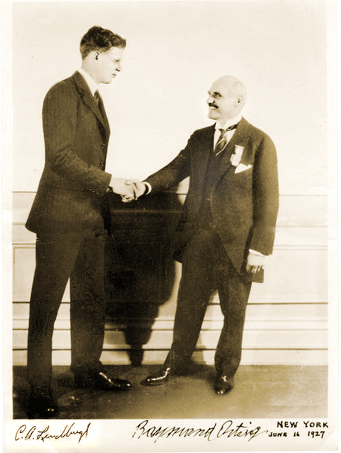
    Charles Lindbergh (left) and Raymond Orteig.
    Charles Lindbergh (left) and Raymond Orteig.

    Enter Lindbergh

    As most of you are aware, then captain, later colonel, Charles Lindbergh took up that dare and won the Orteig-prize on the 21 of May, 1927, when he landed in Paris after a grueling 33½-hour solo flight across the Atlantic. When Lindbergh hit land after being “feet wet” for more than 30 hours and 3500+ miles, he was less than three miles from his intended European entry point, a feat that would be hard to duplicate today without GPS, as even with an unaided inertial system the drift can sometimes be as high as one kilometer per hour.

    One part I always find amusing about the Lindbergh transatlantic saga is that after flying with “dead reckoning” as his only means of navigation for 30 hours across the Atlantic, he followed the Seine river all the way to Paris, so he essentially converted from VFR (Visual Flight Rules) to the IFR or “I fly rivers” navigation method for the last part of his journey.

    Meteorologists and the sealed barometric equipment Lindbergh carried on board — to prove he never landed enroute or that it was indeed a non-stop flight — would not only verify that fact but also verify that he navigated the Atlantic in what we might call today The Perfect Calm. Indeed, Lucky Lindy picked the perfect 48-hour period for his flight. For those of you who read the book, saw the movie, or were there, will remember that in New York the weather during the night preceding his historic takeoff from the dirt-churned-into-mud runway at Roosevelt Field, Long Island, New York, was less than cooperative. There was a major thunderstorm with lots of lightning and several inches of rain; consequently, many counseled Captain Lindbergh to postpone his flight. But he would have none of it and the rest is history.

    The most interesting part of the story, however, is that the entire flight was accomplished with “dead reckoning,” a compass and a watch, the very same tools that Captain Lindbergh used during his tenure as a U.S. Mail pilot. So, in fact, Lucky Lindy actually knew very little about navigating an airplane or avigation, as many called it at the time. Indeed, according to Roger Connor from the National Air and Space Museum and his wonderful article in this month’s Smithsonian Air & Space magazine, Even Lindbergh Got Lost, Captain Lindbergh did not learn to properly navigate with a sextant, chronometer and star charts until more than a year after his famous flight to Paris.

    I won’t spoil the story for you, but he learned to navigate as did his famous wife, Ann Morrow Lindbergh, from then Lieutenant Commander Philip V.H. Weems of the U.S. Navy. LCDR Weems set up the nation’s first independent navigation school, and went on to instruct such notables as General Curtis LeMay, the Commander of Strategic Air Command (SAC), who went on to serve as the Chief of Staff of the USAF. Most people are not aware, but General LeMay was dual-qualified as a pilot and a navigator in the USAF. As the Commander in Chief of SAC or CINCSAC, he mandated that all SAC flight crews be able to navigate from Point A to Point B using only passive means that were always available and did not involve transmitting a signal outside the aircraft. In other words, celestial navigation, using a sextant, chronometer, special plotter and star charts, much as was taught by LCDR Weems.

    I was one of the lucky SAC flight crew members who learned to navigate with those basic instruments. And checking my logbooks, I find that I made just short of 200 flights (99 round-trips) across the big pond, the Pacific that is, using those basic instruments. I mentioned this to a group of USAF aircrews recently during a speech, and when I asked how many of them could accomplish that feat if required to do so today, I was informed that sextants are no longer carried on USAF aircraft and most do not even have sextant ports. In other words, it is a lost art among flight crews today, and it is a shame, but it is also a topic for another time.

    The important fact concerning navigation and time is that time — indeed, precise time — is and always has been critical to accurate navigation, especially aircraft navigation, no matter whether you are flying from New York to Paris, Texas, or New York to Paris, France. And GPS Atomic Reference Systems (Atomic Clocks) on orbit today, which deliver time accurate to millionths of a second, are even more critical since they are the heart of the system. So I would say to my journalist enquirer, GPS and atomic clocks are one and the same. You can’t navigate accurately without precise time.

    Weems Legacy

    Now, to bring this full circle, I first heard about the proposed Smithsonian Time Exhibit about two years ago from a friend and professional colleague, James Doherty, Captain, USCG retired. Jim, who once served as the Commander of the United States Coast Guard Navigation Center, is a past President of ION (Institute of Navigation), one of the few U.S. members of the Royal Institute of Navigation (RIN) in London, England, and now serves as the Chairman of the newly created Military Division at ION. And for full disclosure purposes, I must say that I have been a proud member of ION for more than 30 years.

    Jim, who was serving on a Smithsonian panel as a subject-matter expert on navigation, told me that the Smithsonian had the idea for the time exhibit, but was looking for support, and the first organization to pledge support was indeed ION. The Institute of Navigation certainly does not have the deep pockets of Northrop and Exelis or the other major sponsors, but they are very serious about navigation and they are always looking for ways to promote their vision. This was the perfect opportunity.

    And just in case you were wondering, the legacy that Captain, U.S. Navy, V.H. Weems left the world is a method of celestial navigation that persisted as the primary means, especially in the U.S. military and military forces around the world, for more than 60 years and is still the only reliable means of navigation available to us when everything else goes away. For with the Weems Method, as long as you have a sextant and an accurate clock, you can navigate anywhere.

    Oh, and one other legacy: Captain V.H. Weems was the founder of the Institute of Navigation, which is the leading society devoted to the advancement of navigation in the world today. And for you trivia fans, the ION predates the RIN by two years.

    Sequestration and Cancellations

    Normally I would wrap it up here and say grab your sextant and happy navigating, but just as I wrap this up I have been told by informed sources at SMC and AFCEA that the GPS Partnership Council scheduled for May this year has been postponed. Sources at ION tell me that ION/JNC in Orlando has been cancelled for this year due to the restrictions on travel for U.S. government and military officials. In other words, more victims of sequestration and a Congress that can’t make the decisions we elect and pay them to make.

    At ION they have always had the mantra, do it right or don’t bother doing it at all, and this year the travel restrictions are just too great. Certainly Jim Doherty and I were in the process of setting up another great Warrior Panel for the classified day, but that will have to wait for another time. However, I am assured by ION Executive Director Lisa Beaty that the ION GNSS meeting from September 16-20 at the Nashville Convention Center is definitely a go, so I look forward to seeing everyone there. Stop by the GPS World booth and say hello. Plus, I hope to see many of you at the 29th Annual National Space Symposium in Colorado Springs from April 8-11, 2013.

    Until then, Happy Navigating – blow the dust off your sextant and give it a shot.

  • First Galileo-Only Position Fix Performed!

    First Galileo-Only Position Fix Performed!

    Entitling its release “From Orbit with Love,” the European Space Agency (ESA) proudly announced today, March 12, 2013, that the first four satellites of the future Galileo Satellite Navigation constellation achieved their first-ever autonomous position fix. The positioning was replicated and confirmed by a team at the NavSAS group of Politecnico di Torino, Italy.

    The obtained accuracy lies in the 10-meter range, according to ESA. ESA added that considering the infrastructure is only partly deployed, this fulfills expectations. As with GPS or any satellite navigation system, a minimum of four satellites is required to make a position fix in three dimensions.

    The position fix was obtained by ESA’s navigation laboratory in the Netherlands, using the four satellites, launched in October 2011 and 2012, and the Galileo programme’s ground infrastructure, consisting of control centers in Italy and Germany and a global network of ground stations.

    “This fundamental step confirms the Galileo system works as planned,” read the official statement.

    “Once testing of the latest two satellites was complete, in recent weeks our effort focused on the generation of navigation messages and their dissemination to receivers on the ground,” explained Marco Falcone, ESA’s Galileo system manager.

    Measurements of individual Galileo horizontal position fixes performed for the first time using the four Galileo satellites in orbit plus the worldwide ground system between 1000 and 11:00 CET on Tuesday 12 March 2013, showing an overall horizontal accuracy over ESTEC in Noordwijk, the Netherlands, of 6.3 m.
    Measurements of individual Galileo horizontal position fixes performed for the first time using the four Galileo satellites in orbit plus the worldwide ground system between 1000 and 11:00 CET on Tuesday 12 March 2013, showing an overall horizontal accuracy over ESTEC in Noordwijk, the Netherlands, of 6.3 m.

    This first position fix of longitude, latitude, and altitude took place at the Navigation Laboratory at ESA’s technical heart ESTEC, in Noordwijk, the Netherlands, early on the morning of March 12, with an accuracy between 10 and 15 meters, which was expected, taking into account the limited infrastructure deployed so far.

    “The test of today has a dual significance: historical and technical,” notes Javier Benedicto, ESA’s Galileo project manager. “From the historical perspective, this is the first time ever that Europe has been able to determine a position on the ground using only its own independent navigation system, Galileo. From the technical perspective, generation of the Galileo navigation messages is an essential step for beginning the full validation activities, before starting the full deployment of the system by the end of this year.”

    With only four satellites for the time being, the full Galileo constellation is visible at the same time for a maximum two to three hours daily. This frequency will increase as more satellites join the constellation in orbit, along with extra ground stations coming online, for Galileo’s early services to start at the end of 2014.

    The European Commission’s program head for Galileo, Paul Flament, granted an interview last week with GPS World, recapping the coming launch activities and expectations for initial and full operational capabilities, the latter with a target constellation of 30 satellites. The interview will appear in the April issue of the magazine, which is specially devoted to Galileo and European navigation initiatives.

    With the validation testing activities under way, users might experience breaks in the content of the navigation messages being broadcast, said ESA. In the coming months the messages will be further elaborated to define the offset between Galileo System Time and Coordinated Universal Time (UTC), enabling Galileo to be relied on for precision timing applications, as well as the Galileo to GPS Time Offset, ensuring interoperability with GPS.

    Galileo Is Real, and NavSAS Has the Evidence

    Almost simultaneously with the ESA announcement, the NavSAS group of Politecnico di Torino and Istituto Superiore Mario Boella in Turin, Italy, also achieved a position fix using the signals of the four In-Orbit Validation Galileo satellites (PFM, FM2, FM3, FM4) that started today to broadcast a valid navigation message. The researchers of the NavSAS team successfully computed the positions by using full software receivers developed by the team.

    The positions obtained are depicted in Figure 1, as red squares on the rooftop of the NavSAS Lab in Turin, Italy, where the antenna is positioned (latitude 45°03’54.98767″ N, longitude 7°39’32.28920″ E, height 311.9667 meters). The navigation message was first successfully decoded at 11.28 on March 12.

    Figure 1. Position fixes on the rooftop of the NavSAS lab in Turin, Italy.
    Figure 1. Position fixes on the rooftop of the NavSAS lab in Turin, Italy.

    The configuration of the four Galileo satellites as seen by the NavSAS lab is reported in Figure 2.

    Figure 2. Skyplot of the Galileo IOV satellites at the time of the data acquisition for the fix.
    Figure 2. Skyplot of the Galileo IOV satellites at the time of the data acquisition for the fix.

    The NavSAS team was earlier among the first research teams worldwide able to receive and process the signal of the PFM and FM2 satellites, in December 2011 after the launch of the earliest Galileo IOV satellites, and again at the end of 2012 for the FM3 and FM4.

    The milestone in both accounts of Galileo-only positioning is that it is real-time positioning using the Galileo navigation message. Galileo positioning using a post-processing mode had already been demonstrated, and described by Peter Steigenberger, Urs Hugentobler, and Oliver Montenbruck of the Technische Universität München and the German Space Operations Center, in an account in GPS World, February 2012 issue. (scroll down to “First Demonstration of Galileo-Only Positioning”).

  • Bentley Announces InspectTech Collector Software for iPad

    Bentley Systems, Inc., has announced the immediate availability of InspectTech Collector Mobile for use on the iPad. This new iWare app underscores Bentley’s commitment to providing a broad range of apps for mobile devices that increase information mobility with integrity across engineering disciplines and the infrastructure lifecycle, the company said.

    InspectTech Collector Mobile works with Bentley’s InspectTech software-as-a-service offering, which helps asset owners streamline the process of planning inspections, collecting and managing inspection data, and complying with government reporting requirements — reducing inspection times by up to 25 percent. The new app empowers inspectors of transportation and infrastructure assets — from bridges and culverts to signs, light poles, antenna towers, storm water networks, and more — to quickly and effectively collect a range of inspection information, including photos and audio, in the field on their iPads. By expediting these inspections, InspectTech Collector Mobile enhances inspector productivity and saves owner-operators time and money.

    According to the announcement, through the app users simply sign in to their InspectTech system, and anyone can try the app’s capabilities with access to sample data via Bentley’s new “Explore” trial services program. The app is available for download at no additional charge.

    InspectTech_Collector_ss3The key advantages of InspectTech Collector Mobile include:

    • enhanced inspection efficiency — A streamlined interface delivers valid fields and drop-down boxes as the inspector works through a logical and thorough collection of inspection data;
    • improved inspection quality — Inspectors enhance inspections with the ability to capture photos, audio, and video as they inspect individual assets;
    • reduced inspection costs — Inspectors need no longer travel back to the main office to upload reports, and they enjoy the efficiency associated with the use of a single inspection device that takes the place of multiple inspection tools, including paper and pen, GPS, camera, and audio recorder;
    • increased productivity and reduced errors — Inspectors create comprehensive reports, working quickly and accurately with agency-specific forms and historical asset information;
    • enhanced inspection flexibility — Like all Bentley apps, InspectTech Collector Mobile enables inspectors to work with or without an Internet connection;
    • inspection compliance — Calculations are performed based on National Bridge Inventory (NBI) and other inspection standards;
    • enhanced accuracy – InspectTech Collector Mobile rapidly pinpoints assets using GPS technology;
    • time savings — Synchronization with the organization’s home InspectTech solution via cloud services and automatic generation of high-quality reports speed inspection completion;
    • powerful support for analysis and planning — Inspection data can be provided for planning, performance monitoring, and risk-based analysis and decision making.

    “SCDOT is excited to be testing InspectTech Collector Mobile for bridge inspection data collection,” Lee Floyd, PE, State Bridge Maintenance Engineer, South Carolina Department of Transportation, said. “The Department’s Director of Maintenance Office has been pushing the use of iPads for some time now. We believe that the iPad hardware, along with its stable environment, is an excellent choice for bridge inspection applications. Our early indications are that the InspectTech Collector Mobile software from Bentley is easy to use and will improve our bridge inspection workflow.”

    “InspectTech provides a secure and managed shared source of information for the inspection, inventory, maintenance, and management of transportation physical assets,” Jeremy Shaffer, Bentley director of Transportation Asset Management, said. “It generates savings through better efficiency — from capturing and reviewing inspection data to turning needs into actionable plans – and empowers maintenance management to make the best use of asset inspection information for maintenance planning, prioritization, scheduling, and capital-project decision making. Our new InspectTech Collector Mobile further enhances the flexibility of InspectTech, advancing information mobility within inspection workflows and giving inspectors yet another way to conveniently gather their crucial asset inspection information in the field. This app will also be available to all InspectTech users as an optional data collection add-on for use with the AASHTO Pontis Bridge Management transportation asset management system – as part of the Bentley and AASHTO ongoing partnership.”

  • eSpatial Launches Free Edition of Mapping Software

    eSpatial announced the launch of a free edition of their flagship mapping software, also called eSpatial.

    According to the announcement, eSpatial mapping software lets users convert spreadsheet data into map form. This visualization provides immediate insights into market trends and challenges.

    The new free edition of eSpatial is available to anyone who signs up for an account at www.espatial.com. Once logged on, users can create maps from their existing data and then post them on websites as interactive maps.

    Sales Mapping Software

    Paid editions (including Basic, Pro and Team) of the application with greater functionality – including the ability to handle increased amounts of data, reporting and sharing options – start at $399 for an annual subscription.

    Launching the free edition of eSpatial, company CEO Philip O’Doherty said he hoped this availability of the product would increase awareness of the potential impact of sales mapping software.

    “I think this is a bold move and one that shows us to be an innovator in the mapping market,” he said. “We hope the free edition of our already-successful product will encourage businesses and organizations to think differently about their data and how they can use it to achieve new or continued success.”

  • Esri Introduces Collector for ArcGIS App for Android and iOS

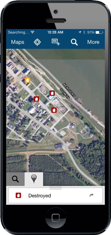
    Esri introduced Collector for ArcGIS, which allows users to capture and report spatial and/or tabular information directly from their iPhone or Android smartphone in the field.

    The Collector for ArcGIS application simplifies data collection in the field. Data can be recorded using GPS or by tapping on the map. The Collector app provides the ability to plan routes, generate directions, capture photos and video, and seamlessly integrate information back into an organization’s GIS. The app can also be configured for use with various tools to help tailor data collection workflows to users’ specific needs.

    The Collector for ArcGIS is available for download from the Apple App Store and Google Play (formerly Android Market).

    The Operations Dashboard and Collector applications are available to organizations that have either a 30-day trial or have purchased an ArcGIS Online subscription..

  • Apple’s $100M Settlement over Kids’ In-App Purchases Sparks Controversy

    Developers and consumers are divided over where responsibility lies around in-app purchases for mobile games by children. Apple’s settlement of a class-action lawsuit over the use of in-app purchases (IAPs) by children for $100 million sparked considerable disagreement across social media.

    According to the terms put forth by Apple, anyone whose children purchased currency, medals, weapons or other virtual goods in an iOS app will be given a $5 iTunes store credit. The parents need to prove they didn’t give their children their iTunes account password, and that the IAPs were made by a minor. If consumers can prove their child spent more than $30, they will be entitled to a full refund rather than an iTunes credit, Apple said.

    While some consumers applauded Apple’s decision, there seems to be concern among some developers that the company gave into undue pressure from those involved in the class action suit.

  • Navigation Test Supplier IFEN Establishes U.S. Company

    IFEN GmbH, based outside of Munich, Germany, has established IFEN Inc. in the United States. The new U.S. company will address the needs of the American market for GNSS test equipment, IFEN said.

    “IFEN Inc., located in Corona, California, will greatly facilitate order placement, delivery and support for U.S. customers,” said Günter Heinrichs, head of Customer Applications and Business Development, of IFEN GmbH. “We look forward to addressing the needs of this market.”

    IFEN has appointed of Mark Wilson vice president of sales at IFEN Inc. Wilson has more than 20 years of experience in the GNSS market. “I am very excited to join the IFEN team. They have extensive experience in all aspects of GNSS and I am looking forward to offering this expertise and the excellent IFEN products to the American Market,” Wilson said. “Our exceptional products offer unrivaled flexibility and capability, at realistic prices providing huge advantages to our customers.”

    IFEN has more than 15 years of experience in GNSS and offers a range of GNSS test equipment, including simulators capable of simulating all GNSS constellations and frequencies and a multi-GNSS software receiver.

  • ION Cancels 2013 Joint Navigation Conference

    The Institute of Navigation (ION) Military Division has canceled this year’s Joint Navigation Conference (JNC), which was scheduled to take place in Orlando, Florida, June 10-13.

    “This decision has not been taken lightly but due to the DOD’s recent policies detailing actions to be taken to prepare for drastic budget cuts, the curtailment of travel, fallout from a scandal with GSA conferences this past year, the current sequestration, and possible furloughs for federal employees, it is no longer possible for ION to ensure the JNC will be able to maintain a high-quality technical program and sufficient networking opportunities that makes the JNC so valuable to DOD/DHS employees and their supporting organizations,” wrote Lisa Beaty, ION executive director, in a statement.

    “While it is impossible for us to predict the duration of the current federal climate, the ION is committed to keeping the Institute on a sure and steady track,” Beaty wrote. The 2014 JNC is still scheduled for June 16-19, 2014, at the Renaissance Orlando at SeaWorld, Orlando, Florida, with the classified session and warfighter panel being held at Shades of Green at Walt Disney World Resort on June 19.

    All JNC 2013 registered attendees, exhibitors, and sponsors will receive a full refund of fees paid. Registrants and exhibitors are reminded that they are responsible for cancelling their own hotel reservations, and other travel-related arrangements. To cancel reservations at the Renaissance Orlando at SeaWorld, call 1-407-351-5555 or 1-800-327-6677, or cancel your reservation online.

  • Rolls-Royce Wraith Selects Gears Using GPS

    Rolls-Royce Wraith Selects Gears Using GPS

    The 2014 Rolls-Royce Wraith coupe is using GPS to make a smooth ride even smoother.

    Unveiled at the 2013 Geneva Motor Show, the Wraith is the fastest, most powerful car Rolls-Royce has ever made at $320,000 ($245,000 euros). The Wraith’s eight-speed automatic transmission is linked to a GPS receiver. The car uses satellites to constantly determine what road you’re driving on and in what conditions, then uses the data to anticipate when to shift gears.

    For example, it can downshift the moment a hill or curve is approached, which helps with both performance and fuel economy, Rolls said. The nav system also compiles real-time traffic data from cellphones in commercial vehicles and taxis, and uses the data to update the travel route every three minutes.

    The debut of Satellite Aided Transmission technology takes the power train to a new level of effortless delivery, the automaker said, allowing the car to “see into the future.”

    According to the Rolls, Satellite Aided Transmission uses GPS data and the navigation system to scan the road. It anticipates his next move based on location and current driving style, then automatically chooses the optimum gear on the eight-speed transmission. “Power is delivered effortlessly for you, so you can surge through every corner, round every roundabout and into every slip road smoothly,” Rolls-Royce said.

    The high-tech doesn’t stop with GPS. The Wraith has a heads-up display, voice command support and an infotainment system with multi-touch trackpad and 10-inch screen.

    Start saving your pennies. The Rolls goes on sale this fall.

  • GIS Crucial to Australian Flood Response

    A leading water management adviser in Australia has said that the use of mapping and surveying technology is crucial to help the country protect itself against frequent severe floods, reports Doug Murphy of SurveyEquipment.com.

    Georgina Race, spatial analyst at Flood Prevention Experts, told an audience of 200 spatial professionals in Melbourne that GIS technology must become integral flooding event preparation and response.

    This past year, heavy rainfall has caused flooding in several regions in Australia, necessitating mass evacuations and costing hundreds of millions of dollars in insurance claims.

    Captain Charlie Mansfield, Lance Corporal Ken Leahy and Sapper John Wainwright help remove debris from the Balonne River bridge in St George, Queensland.
    Australian Army Captain Charlie Mansfield, Lance Corporal Ken Leahy and Sapper John Wainwright help remove debris from the Balonne River bridge in St George, Queensland.

    “GIS technology enables us to map the massive amounts of data that must be taken into consideration when projecting the outcome of large rainfall events,” she said. “This data includes land elevation and characteristics, past flood levels, infrastructure building information and seawater levels. The technology brings all this information together and allows us to run modelling of the impacts of various rainfall scenarios — such as storm events, sea level rises and even new building and infrastructure developments — to understand the level of inundation that may take place.”

    Australia Prime Minister Julia Gillard announced in February that the federal government will invest $100 million over two years into flood mitigation projects to help reduce flood risk and bring about reductions in insurance premiums.

  • Cambridge Consultants Unveils Indoor Locator System

    Cambridge Consultants Unveils Indoor Locator System

    Tracking_O

    New technology from product development firm Cambridge Consultants can accurately detect someone’s location indoors when GPS drops out. A number of sensors and a custom algorithm determine the location, with an accuracy of within approximately 1 percent of the distance traveled.

    Close_up-WThe technology uses low-power, low-cost sensors and the device concept is small enough to clip on a belt. It also doesn’t need any existing internal infrastructure.

    “We are excited about the many possibilities this cutting-edge technology opens up and the impact it can have in many different situations,” said Geoff Smithson, technology director, sensing systems, at Cambridge Consultants. “It could be used to help locate firefighters in smoke-filled buildings, for example, or to pinpoint the closest doctor in a hospital during an emergency — or to track offenders during home curfews. We are just starting to see the potential of this approach and the diverse demand for this type of low-energy, highly accurate system.”

    Indoor tracking systems, which process data from one or more sources of location information to estimate where a person or object is located, are not new. But they often rely on RF signals from Wi-Fi access points or custom infrastructure, poor-quality GPS signals or expensive, high-quality sensors. The availability of low-cost smartphone components — including accelerometers, gyroscopes, magnetometers and pressure sensors — has enabled a new generation of location devices and applications, when combined with a tailored Bayesian algorithm to fuse the information.

    Handset-WThe new technology platform can be embedded in an existing design or operate as a stand-alone unit, with options to compute the location locally or transmit the information to a remote system that can process the data before visualizing it on a smartphone app.

    “Our biggest challenges were developing an algorithm which optimally combines the data from GPS and the other sensors, and overcoming the issues of using such low-cost sensors in a system without any absolute location reference,” said Smithson.

    Cambridge Consultants specializes in developing low-cost, low-power connected devices for clients with a team of experts with sensing, wireless and software  engineering expertise. The latest technology builds on the company’s tracking and location systems experience in a variety of market sectors ranging from defense and security to consumer, industrial, and oil and gas.

  • Futuristic Heads-up Glasses with GPS Go to App Developers

    Futuristic Heads-up Glasses with GPS Go to App Developers

    Google-glass-nav-image

    Vuzix Corporation today announced that it has begun shipping M100 Smart Glasses to the first of its Gold developer partners — enabling them to start creating and testing their apps on the real hardware.

    The M100 Smart Glasses are a smart hands-free display and communications device for mobile data access, once paired to a smartphone and connected to the Internet. The glasses include an integrated head tracker and GPS for spatial and positional awareness.

    Vuzix is a supplier of Video Eyewear products in the consumer, commercial and entertainment markets.

    Google glass.
    Google Glass

    The M100 is in competition — and a race to market — with Google Glass, a similar wearable device. Google recently held a contest to provide sample sets of the glasses to non-developers willing to pay $1,500 — which encouraged Internet and media buzz.

    M100 Smart Glasses
    M100 Smart Glasses

    Google Glass could be released to the mass market by the end of the year. Google Inc. already sold an unspecified number of the glasses to developers who also paid $1,500 apiece at a company conference in June 2012. The mass-market version of Google Glass is expected to cost less than $1,500, but more than a smartphone.

    Like the M100, Google Glass is intended to perform many of the same tasks as smartphones. The glasses include a little display screen attached to a rim above the right eye, run on Google’s Android operating system, and respond to voice commands, which is intended to make it easier for people to take pictures or record video wherever they might be (such as skydiving or riding a rollercoaster). Here is a video showing the glasses in action:

    When he demonstrated the glasses at last June’s company conference, Google co-founder Sergey Brin acknowledged the company was still working out bugs and trying to figure out how to extend the product’s battery life.

    Privacy Concerns. The ease of taking pictures and recording video with the glasses is causing some to question whether privacy will be affected.  zdnet blogger Ben Woods writes, “These glasses can instantly capture and store every move of everyone around the person wearing them. Remember that drunken argument you had with your partner? Well, now Google Glass will mean you have no possibility of forgetting it. If it’s entertaining enough, or you’re well-known enough, the video of that argument could well be on YouTube before you get home. Do you do a lot of business on the phone while out and about or while sitting in coffee shops? Will you continue to, if you know that every call could be recorded by the stranger sitting at the table opposite, staring innocently at the picture on the wall behind your head?”

    Google first began developing the glasses in 2010 as part of a secretive company division now known as Google X.

    How the M100 is worn.
    How the M100 is worn.

    Vuzix Showstopper. Displayed at Mobile World Congress in February as a “Showstopper,” the M100 contains a near-eye micro display with an integrated camera and powerful processor running an Android OS. It connects wirelessly to a user’s smartphone (iOS or Android) or other compatible device via Bluetooth or Wi-Fi, can connect directly to the Internet, and run applications and games on its own. Working in harmony with a user’s smartphone, the M100 enables access to a vast array of existing and future text, video, GPS, and audio applications, Vuzix said.

    With the glasses, users can answer the phone using a visual address book, record video and run applications, including basic augmented reality apps. Interactive tracking and an integrated camera, combined with newly developed applications on the M100 and a wireless link to the Cloud, enable the merging of virtual information with the real world. An integrated camera enables video recording, still image capture and the potential for powerful augmented reality applications.

    Industry, Medical. “Although we are seeing applications developed in most every market, there has been a strong focus on the industrial and medical markets,” said Paul J. Travers, chief executive officer.

    “Our Company has a focus on developing the fundamental tools that enable applications from training to warehousing,” said Pete Wassell, president of Augmate Corporation, one of the first M100 Gold developers. “This new category of device is going to revolutionize many markets by injecting cloud-connected, hands-free and geospatially accurate information to applications that desperately need it. The M100 does a great job of delivering on that promise.”

    The Vuzix developer program offers early access to the M100 smart glasses, technical support and advice. The M100 software developers kit is available in two versions, Gold and Silver. These SDKs are being delivered in stages and include frequent updates, hardware advances when released, and access to the developer center to provide technical and developer community support.

    Because the demand is strong, Vuzix is delivering the first smart glasses on a first-come, first-served basis with custom-built prototypes going exclusively to its Gold Developers.