Blog

  • Straight Talk on Anti-Spoofing: Securing the Future of PNT

    By Kyle Wesson, Daniel Shepard, and Todd Humphreys

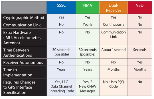
    Disruption created by intentional generation of fake GPS signals could have serious economic consequences. This article discusses how typical civil GPS receivers respond to an advanced civil GPS spoofing attack, and four techniques to counter such attacks: spread-spectrum security codes, navigation message authentication, dual-receiver correlation of military signals, and vestigial signal defense. Unfortunately, any kind of anti-spoofing, however necessary, is a tough sell.

    GPS spoofing has become a hot topic. At the 2011 Institute of Navigation (ION) GNSS conference, 18 papers discussed spoofing, compared with the same number over the past decade. ION-GNSS also featured its first panel session on anti-spoofing, called “Improving Security of GNSS Receivers,” which offered six security experts a forum to debate the most promising anti-spoofing technologies.

    The spoofing threat has also drawn renewed U.S. government scrutiny since the initial findings of the 2001 Volpe Report. In November 2010, the U.S. Position Navigation and Timing National Executive Committee requested that the U.S. Department of Homeland Security (DHS) conduct a comprehensive risk assessment on the use of civil GPS. In February 2011, the DHS Homeland Infrastructure Threat and Risk Analysis Center began its investigation in conjunction with subject-matter experts in academia, finance, power, and telecommunications, among others. Their findings will be summarized in two forthcoming reports, one on the spoofing and jamming threat and the other on possible mitigation techniques. The reports are anticipated to show that GPS disruption due to spoofing or jamming could have serious economic consequences.

    Effective techniques exist to defend receivers against spoofing attacks. This article summarizes state-of-the-art anti-spoofing techniques and suggests a path forward to equip civil GPS receivers with these defenses. We start with an analysis of a typical civil GPS receiver’s response to our laboratory’s powerful spoofing device. This will illustrate the range of freedom a spoofer has when commandeering a victim receiver’s tracking loops. We will then provide an overview of promising cryptographic and non-cryptographic anti-spoofing techniques and highlight the obstacles that impede their widespread adoption.

    The Spoofing Threat

    Spoofing is the transmission of matched-GPS-signal-structure interference in an attempt to commandeer the tracking loops of a victim receiver and thereby manipulate the receiver’s timing or navigation solution. A spoofer can transmit its counterfeit signals from a stand-off distance of several hundred meters or it can be co-located with its victim.

    Spoofing attacks can be classified as simple, intermediate, or sophisticated in terms of their effectiveness and subtlety. In 2003, the Vulnerability Assessment Team at Argonne National Laboratory carried off a successful simple attack in which they programmed a GPS signal simulator to broadcast high-powered counterfeit GPS signals toward a victim receiver. Although such a simple attack is easy to mount, the equipment is expensive, and the attack is readily detected because the counterfeit signals are not synchronized to their authentic counterparts.

    In an intermediate spoofing attack, a spoofer synchronizes its counterfeit signals with the authentic GPS signals so they are code-phase-aligned at the target receiver. This method requires a spoofer to determine the position and velocity of the victim receiver, but it affords the spoofer a serious advantage: the attack is difficult to detect and mitigate.

    The sophisticated attack involves a network of coordinated intermediate-type spoofers that replicate not only the content and mutual alignment of visible GPS signals but also their spatial distribution, thus fooling even multi-antenna spoofing defenses.

    Table1 . Credit: Kyle Wesson, Daniel Shepard, and Todd Humphreys
    Table 1. Comparison of anti-spoofing techniques discussed in this article.

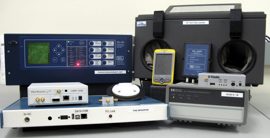
    Lab Attack. So far, no open literature has reported development or research into the sophisticated attack. This is likely because of the success of the intermediate-type attack: to date, no civil GPS receiver tested in our laboratory has fended off an intermediate-type spoofing attack. The spoofing attacks, which are always conducted via coaxial cable or in radio-frequency test enclosures, are performed with our laboratory’s receiver-spoofer, an advanced version of the one introduced at the 2008 ION-GNSS conference (see “Assessing the Spoofing Threat,” GPS World, January 2009).

    To commence the attack, the spoofer transmits its counterfeit signals in code-phase alignment with the authentic signals but at power level below the noise floor. The spoofer then increases the power of the spoofed signals so that they are slightly greater than the power of the authentic signals. At this point, the spoofer has taken control of the victim receiver’s tracking loops and can slowly lead the spoofed signals away from the authentic signals, carrying the receiver’s tracking loops with it. Once the spoofed signals have moved more than 600 meters in position or 2 microseconds in time away from the authentic signals, the receiver can be considered completely owned by the spoofer.

    Spoofing testbed at the University of Texas Radionavigation Laboratory, an advanced and powerful suite for anti-spoofing research. On the right are several of the civil GPS receivers tested and the radio-frequency test enclosure, and on the left are the phasor measurement unit and the civil GPS spoofer. Credit: Kyle Wesson, Daniel Shepard, and Todd Humphreys
    Spoofing testbed at the University of Texas Radionavigation Laboratory, an advanced and powerful suite for anti-spoofing research. On the right are several of the civil GPS receivers tested and the radio-frequency test enclosure, and on the left are the phasor measurement unit and the civil GPS spoofer.

    Although our spoofer fooled all of the receivers tested in our laboratory, there are significant differences between receivers’ dynamic responses to spoofing attacks. It is important to understand the types of dynamics that a spoofer can induce in a target receiver to gain insight into the actual dangers that a spoofing attack poses rather than rely on unrealistic assumptions or models of a spoofing attack. For example, a recent paper on time-stamp manipulation of the U.S. power grid assumed that there was no limit to the rate of change that a spoofer could impose on a victim receiver’s position and timing solution, which led to unrealistic conclusions.

    Experiments performed in our laboratory sought to answer three specific questions regarding spoofer-induced dynamics:

    • How quickly can a timing or position bias be introduced?
    • What kinds of oscillations can a spoofer cause in a receiver’s position and timing?
    • How different are receiver responses to spoofing?

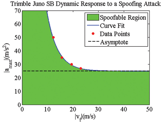
    These questions were answered by determining the maximum spoofer-induced pseudorange acceleration that can be used to reach a certain final velocity when starting from a velocity of zero, without raising any alarms or causing the target receiver to lose satellite lock. The curve in the velocity-acceleration plane created by connecting these points defines the upper bound of a region within which the spoofer can safely manipulate the target receiver. These data points can be obtained empirically and fit to an exponential curve. Alarms on the receiver may cause some deviations from this curve depending on the particular receiver.

    Figure 1 shows an example of the velocity-acceleration curve for a high-quality handheld receiver, whose position and timing solution can be manipulated quite aggressively during a spoofing attack. These results suggest that the receiver’s robustness — its ability to provide navigation and timing solutions despite extreme signal dynamics — is actually a liability in regard to spoofing. The receiver’s ability to track high accelerations and velocities allows a spoofer to aggressively manipulate its navigation solution.

     Figure 1. Theoretical and experimental test results for a high-quality handheld receiver's dynamic response to a spoofing attack. Although not shown here, the maximum attainable velocity is around 1,300 meters/second.  Credit: Kyle Wesson, Daniel Shepard, and Todd Humphreys
    Figure 1. Theoretical and experimental test results for a high-quality handheld receiver’s dynamic response to a spoofing attack. Although not shown here, the maximum attainable velocity is around 1,300 meters/second.

    The relative ease with which a spoofer can manipulate some GPS receivers suggests that GPS-dependent infrastructure is vulnerable. For example, the telecommunications network and the power grid both rely on GPS time-reference receivers for accurate timing. Our laboratory has performed tests on such receivers to determine the disruptions that a successful spoofing attack could cause. The remainder of this section highlights threats to these two sectors of critical national infrastructure.

    Cell-Phone Vulnerability. Code division multiple access (CDMA) cell-phone towers rely on GPS timing for tower-to-tower synchronization. Synchronization prevents towers from interfering with one another and enables call hand-off between towers. If a particular tower’s time estimate deviates more than 10 microseconds from GPS time, hand-off to and from that tower is disrupted. Our tests indicate that a spoofer could induce a 10-microsecond time deviation within about 30 minutes for a typical CDMA tower setup. A spoofer, or spoofer network, could also cause multiple neighboring towers to interfere with one another. This is possible because CDMA cell-phone towers all use the same spreading code and distinguish themselves only by the phasing (that is, time offset) of their spreading codes. Furthermore, it appears that a spoofer could impair CDMA-based E911 user-location.

    Power-Grid Vulnerability. Like the cellular network, the power grid of the future will rely on accurate GPS time-stamps. The efficiency of power distribution across the grid can be improved with real-time measurements of the voltage and current phasors. Phasor measurement units (PMUs) have been proposed as a smart-grid technology for precisely this purpose. PMUs rely on GPS to time-stamp their measurements, which are sent back to a central monitoring station for processing. Currently, PMUs are used for closed-loop grid control in only a few applications, but power-grid modernization efforts will likely rely more heavily on PMUs for control. If a spoofer manipulates a PMU’s time stamps, it could cause spurious variations in measured phase angles. These variations could distort power flow or stability estimates in such a way that grid operators would take incorrect or unnecessary control actions including powering up or shutting down generators, potentially causing blackouts or damage to power-grid equipment.

    Under normal circumstances, a changing separation in the phase angle between two PMUs indicates changes in power flow between the regions measured by each PMU. Tests demonstrate that a spoofer could cause variations in a PMU’s measured voltage phase angle at a rate of 1.73 degrees per minute. Thus, a spoofing attack could create the false indications of power flow across the grid. The tests results also reveal, however, that it is impossible for a spoofer to cause changes in small-signal grid stability estimates, which would require the spoofer to induce rapid (for example, 0.1–3 Hz) microsecond-amplitude oscillations in timing. Such oscillations correspond to spoofing dynamics well outside the region of freedom of all receivers we have tested. A spoofer might also be able to affect fault-location estimates obtained through time-difference-of-arrival techniques using PMU measurements. This could cause large errors in fault-location estimates and hamper repair efforts.

    What Can Be Done? Despite the success of the intermediate-type spoofing attack against a wide variety of civil GPS receivers and the known vulnerabilities of GPS-dependent critical infrastructure to spoofing attacks, anti-spoofing techniques exist that would enable receivers to successfully defend themselves against such attacks. We now turn to four promising anti-spoofing techniques.

    Cryptographic Methods

    These techniques enable a receiver to differentiate authentic GPS signals from counterfeit signals with high likelihood. Cryptographic strategies rely on the unpredictability of so-called security codes that modulate the GPS signal. An unpredictable code forces a spoofer who wishes to mount a successful spoofing attack to either

    • estimate the unpredictable chips on-the-fly, or
    • record and play back authentic GPS spectrum (a meaconing attack).

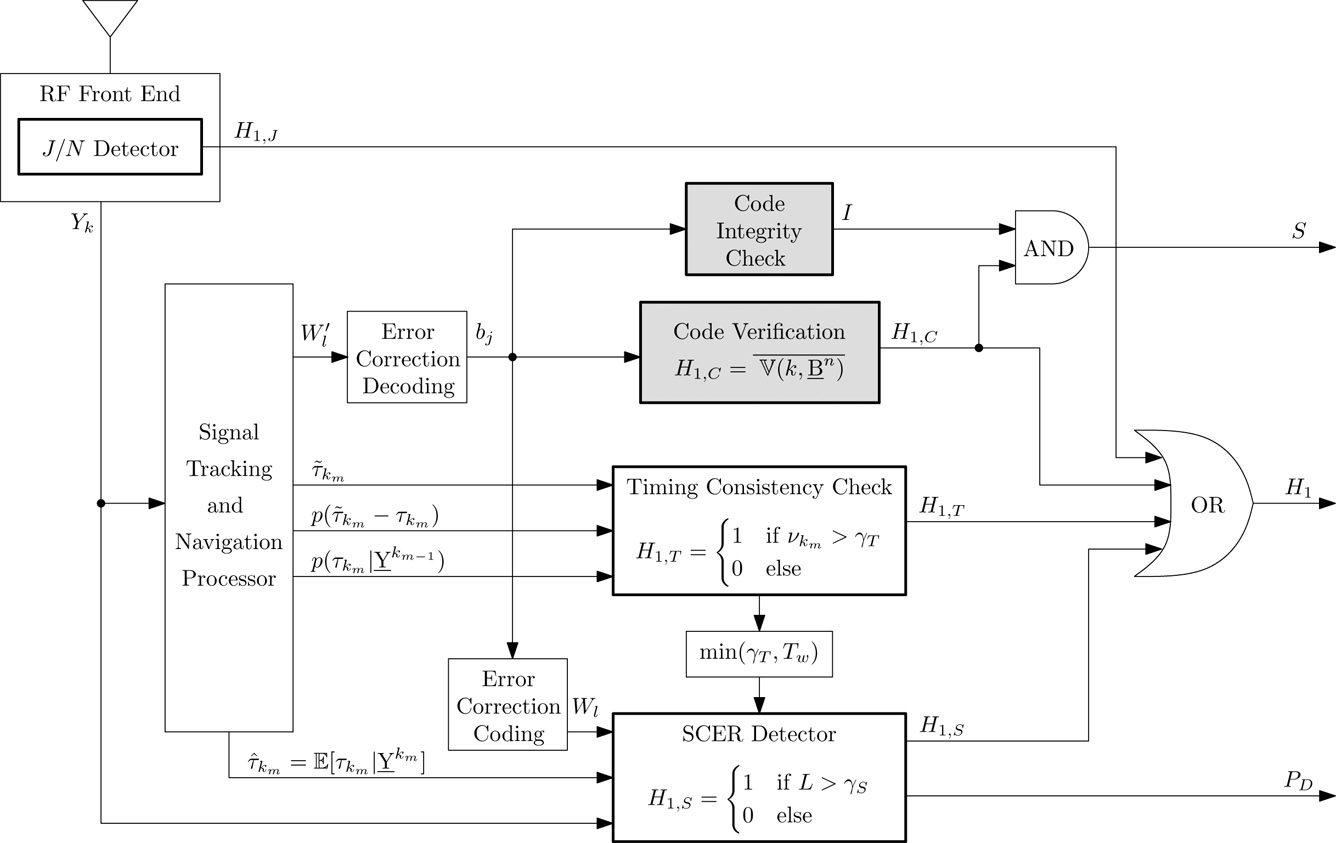
    To avoid unrealistic expectations, it should be noted that no anti-spoofing technique is completely impervious to spoofing. GPS signal authentication is inherently probabilistic, even when rooted in cryptography. Many separate detectors and cross-checks, each with its own probability of false alarm, are involved in cryptographic spoofing detection. Figure 2 illustrates how the jammer-to-noise ratio detector, timing consistency check, security-code estimation and replay attack (SCER) detector, and cryptographic verification block all work together. This hybrid combination of statistical hypothesis tests and Boolean logic demonstrates the complexities and subtleties behind a comprehensive, probabilistic GPS signal authentication strategy for security-enhanced signals.

     Figure 2. GNSS receiver components required for GNSS signal authentication. Components that support code origin authentication are outlined in bold and have a gray fill, whereas components that support code timing authentication are outlined in bold and have no fill. The schematic assumes a security code based on navigation message authentication.  Credit: Kyle Wesson, Daniel Shepard, and Todd Humphreys
    Figure 2. GNSS receiver components required for GNSS signal authentication. Components that support code origin authentication are outlined in bold and have a gray fill, whereas components that support code timing authentication are outlined in bold and have no fill. The schematic assumes a security code based on navigation message authentication.

    Spread Spectrum Security Codes. In 2003, Logan Scott proposed a cryptographic anti-spoofing technique based on spread spectrum security codes (SSSCs). The most recent proposed version of this technique targets the L1C signal, which will be broadcast on GPS Block III satellites, because the L1C waveform is not yet finalized. Unpredictable SSSCs could be interleaved with the L1C spreading code on the L1C data channel, as illustrated in Figure 3. Since L1C acquisition and tracking occurs on the pilot channel, the presence of the SSSCs has negligible impact on receivers. Once tracking L1C, a receiver can predict when the next SSSC will be broadcast but not its exact sequence. Upon reception of an SSSC, the receiver stores the front-end samples corresponding to the SSSC interval in memory. Sometime later, the cryptographic digital key that generated the SSSC is transmitted over the navigation message. With knowledge of the digital key, the receiver generates a copy of the actual transmitted SSSC and correlates it with the previously-recorded digital samples. Spoofing is declared if the correlation power falls below a pre-determined threshold.

     Figure 3. Placement of the periodically unpredictable spread spectrum security codes in the GPS L1C data channel spreading sequence.  Credit: Kyle Wesson, Daniel Shepard, and Todd Humphreys
    Figure 3. Placement of the periodically unpredictable spread spectrum security codes in the GPS L1C data channel spreading sequence.

    When the security-code chip interval is short (high chipping rate), it is difficult for a spoofer to estimate and replay the security code in real time. Thus, the SSSC technique on L1C offers a strong spoofing defense since the L1C chipping rate is high (that is, 1.023 MChips/second). Furthermore, the SSSC technique does not rely on the receiver obtaining additional information from a side channel; all the relevant codes and keys are broadcast over the secured GPS signals. Of course a disadvantage for SSSC is that it requires a fairly fundamental change to the currently-proposed L1C definition: the L1C spreading codes must be altered.

    Implementation of the SSSC technique faces long odds, partly because it is late in the L1C planning schedule to introduce a change to the spreading codes. Nonetheless, in September 2011, Logan Scott and Phillip Ward advocated for SSSC at the Public Interface Control Working Group meeting, passing the first of many wickets. The proposal and associated Request for Change document will now proceed to the Lower Level GPS Engineering Requirements Branch for further technical review. If approved there, it passes to the Joint Change Review Board for additional review and, if again approved, to the Technical Interchange Meeting for further consideration. The chances that the SSSC proposal will survive this gauntlet would be much improved if some government agency made a formal request to the GPS Directorate to include SSSCs in L1C — and provided the funding to do so. The DHS seems to us a logical sponsoring agency.

    Navigation Message Authentication. If an L1C SSSC implementation proves unworkable, an alternative, less-invasive cryptographic authentication scheme based on navigation message authentication (NMA) represents a strong fall-back option. In the same 2003 ION-GNSS paper that he proposed SSSC, Logan Scott also proposed NMA. His paper was preceded by an internal study at MITRE and followed by other publications in the open literature, all of which found merit in the NMA approach. The NMA technique embeds public-key digital signatures into the flexible GPS civil navigation (CNAV) message, which offers a convenient conveyance for such signatures. The CNAV format was designed to be extensible so that new messages can be defined within the framework of the GPS Interference Specification (IS). The current GPS IS defines only 15 of 64 CNAV messages, reserving the undefined 49 CNAV messages for future use.

    Our lab recently demonstrated that NMA works to authenticate not only the navigation message but also the underlying signal. In other words, NMA can be the basis of comprehensive signal authentication. We have  proposed a specific implementation of NMA that is packaged for immediate adoption. Our proposal defines two new CNAV messages that deliver a standardized public-key elliptic-curve digital algorithm (ECDSA) signature via the message format in Figure 4.

    Figure 4. Format of the proposed CNAV ECDSA signature message, which delivers the first or second half of the 466-bit ECDSA signature and a 5-bit salt in the 238-bit payload field. Credit: Kyle Wesson, Daniel Shepard, and Todd Humphreys
    Figure 4. Format of the proposed CNAV ECDSA signature message, which delivers the first or second half of the 466-bit ECDSA signature and a 5-bit salt in the 238-bit payload field.

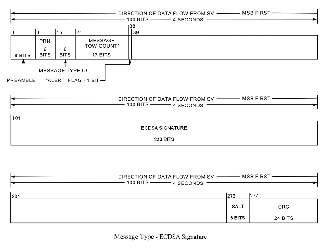
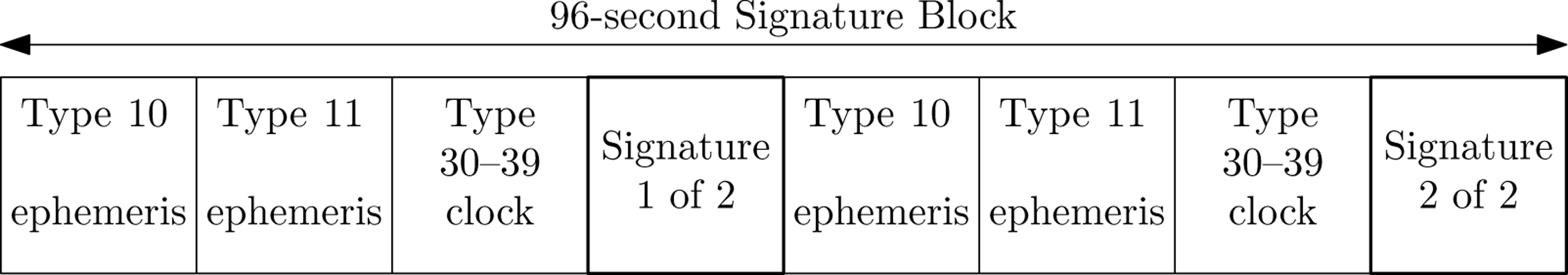
    Although the CNAV message format is flexible, it is not without constraints. The shortest block of data in which a complete signature can be embedded is a 96-second signature block such as the one shown in Figure 5. In this structure, the two CNAV signature messages are interleaved between the ephemeris and clock data to meet the broadcast requirements.

     Figure 5. The shortest broadcast signature block that does not violate the CNAV ephemeris and timing broadcast requirements. To meet the required broadcast interval of 48 seconds for message types 10, 11, and one of 30–39, the ECDSA signature is broadcast over a 96-second signature block that is composed of eight CNAV messages.  Credit: Kyle Wesson, Daniel Shepard, and Todd Humphreys
    Figure 5. The shortest broadcast signature block that does not violate the CNAV ephemeris and timing broadcast requirements. To meet the required broadcast interval of 48 seconds for message types 10, 11, and one of 30–39, the ECDSA signature is broadcast over a 96-second signature block that is composed of eight CNAV messages.

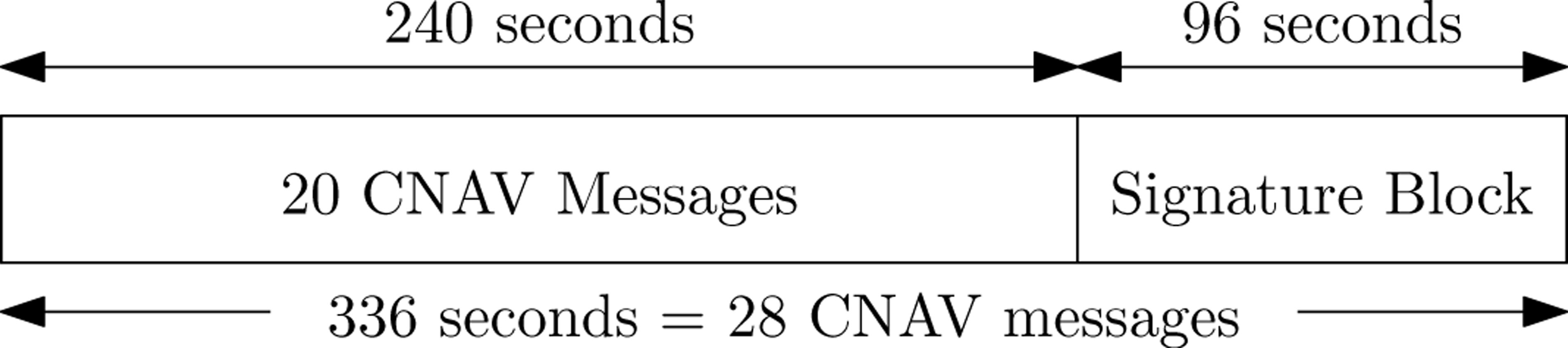
    The choice of the duration between signature blocks is a tradeoff between offering frequent authentication and maintaining a low percentage of the CNAV message reserved for the digital signature. In our proposal, signature blocks are transmitted roughly every five minutes (Figure 6) so that only 7.5 percent of the navigation message is devoted to the digital signature. Across the GPS constellation, the signature block could be offset so that a receiver could authenticate at least one channel approximately every 30 seconds. Like SSSC, our proposed version of NMA does not require a receiver’s getting additional information from a side channel, provided the receiver obtains public key updates on a yearly basis.

    message_sig_block .  Credit: Kyle Wesson, Daniel Shepard, and Todd Humphreys
    Figure 6. A signed 336-second broadcast. The proposed strategy signs every 28 CNAV messages with a signature broadcast over two CNAV messages on each broadcast channel.

    NMA is inherently less secure than SSSC. A NMA security code chip interval (that is, 20 milliseconds) is longer than a SSSC chip interval, thereby allowing the spoofer more time to estimate the digital signature on-the-fly. That is not to say, however, that NMA is ineffective. In fact, tests with our laboratory’s spoofing testbed demonstrated the NMA-based signal authentication structure described earlier offered a receiver a better-than 95 percent probability of detecting a spoofing attack for a 0.01 percent probability of false alarm under a challenging spoofing-attack scenario.

    NMA is best viewed as a hedge. If the SSSC approach does not gain traction, then NMA might, since it only requires defining two new CNAV messages in the GPS IS — a relatively minor modification. CNAV-based NMA could defend receivers tracking L2C and L5. A new CNAV2 message will eventually be broadcast on L1 via L1C, so a repackaged CNAV2-based NMA technique could offer even single-frequency L1 receivers a signal-side anti-spoofing defense.

    P(Y) Code Dual-Receiver Correlation. This approach avoids entirely the issue of GPS IS modifications. The technique correlates the unknown encrypted military P(Y) code between two civil GPS receivers, exploiting known carrier-phase and code-phase relationships. It is similar to the dual-frequency codeless and semi-codeless techniques that civil GPS receivers apply to track the P(Y) code on L2. Peter Levin and others filed a patent on the codeless-based signal authentication technique in 2008; Mark Psiaki extended the approach to semicodeless correlation and narrow-band receivers in a 2011 ION-GNSS paper.

    In the dual-receiver technique, one receiver, stationed in a secure location, tracks the authentic L1 C/A codes while receiving the encrypted P(Y) code. The secure receiver exploits the known timing and phase relationships between the C/A code and P(Y) code to isolate the P(Y) code, of which it sends raw samples (codeless technique) or estimates of the encrypting W-code chips (semi-codeless technique) over a secure network to the defending receiver. The defending receiver correlates its locally-extracted P(Y) with the samples or W-code estimates from the secure receiver. If a spoofing attack is underway, the correlation power will drop below a statistical threshold, thereby causing the defending receiver to declare a spoofing attack. Although the P(Y) code is 20 MHz wide, a narrowband civil GPS receiver with 2.6 MHz bandwidth can still perform the statistical hypothesis tests even with the resulting 5.5 dB attenuation of the P(Y) code. Because the dual-receiver method can run continuously in the background as part of a receiver’s standard GPS signal processing, it can declare a spoofing attack within seconds — a valuable feature for many applications.

    Two considerations about the dual-receiver technique are worth noting. First, the secure receiver must be protected from spoofing for the technique to succeed. Second, the technique requires a secure communication link between the two receivers. Although the first requirement is easily achieved by locating secure receivers in secure locations, the second requirement makes the technique impractical for some applications that cannot support a continuous communication link.

    Of all the proposed cryptographic anti-spoofing techniques, only the dual-receiver method could be implemented today. Unfortunately the P(Y) code will no longer exist after 2021, meaning that systems that make use of the P(Y)-based dual-receiver technique will be rendered unprotected, although a similar M-code-based technique could be an effective replacement. The dual-receiver method, therefore, is best thought of as a stop-gap: it can provide civil GPS receivers with an effective anti-spoofing technique today until a signal-side civil GPS authentication technique is approved and implemented in the future This sentiment was the consensus of the panel experts at the 2011 ION-GNSS session on civil GPS receiver security.

    Non-Cryptographic Methods

    Non-cryptographic techniques are enticing because they can be made receiver-autonomous, requiring neither security-enhanced civil GPS signals nor a side-channel communication link. The literature contains a number of proposed non-cryptographic anti-spoofing techniques. Frequently, however, these techniques rely on additional hardware, such as accelerometers or inertial measurements units, which may exceed the cost, size, or weight requirements in many applications. This motivates research to develop software-based, receiver-autonomous anti-spoofing methods.

    Vestigial Signal Defense (VSD). This software-based, receiver-autonomous anti-spoofing technique relies on the difficulty of suppressing the true GPS signal during a spoofing attack. Unless the spoofer generates a phase-aligned nulling signal at the phase center of the victim GPS receiver’s antenna, a vestige of the authentic signal remains and manifests as a distortion of the complex correlation function. VSD monitors distortion in the complex correlation domain to determine if a spoofing attack is underway.

    To be an effective defense, the VSD must overcome a significant challenge: it must distinguish between spoofing and multipath. The interaction of the authentic and spoofed GPS signals is similar to the interaction of direct-path and multipath GPS signals. Our most recent work on the VSD suggests that differentiating spoofing from multipath is enough of a challenge that the goal of the VSD should only be to reduce the degrees-of-freedom available to a spoofer, forcing the spoofer to act in a way that makes the spoofing signal or vestige of the authentic GPS signal mimic multipath. In other words, the VSD seeks to corner the spoofer and reduce its space of possible dynamics.

    Among other options, two potential effective VSD techniques are

    • a maximum-likelihood bistatic-radar-based approach and
    • a phase-pseudorange consistency check.

    The first approach examines the spatial and temporal consistency of the received signals to detect inconsistencies between the instantaneous received multipath and the typical multipath background environment. The second approach, which is similar to receiver autonomous integrity monitoring (RAIM) techniques, monitors phase and pseudorange observables to detect inconsistencies potentially caused by spoofing. Again, a spoofer can act like multipath to avoid detection, but this means that the VSD would have achieved its modest goal.

    Anti-Spoofing Reality Check

    Security is a tough sell. Although promising anti-spoofing techniques exist, the reality is that no anti-spoofing techniques currently defend civil GPS receivers. All anti-spoofing techniques face hurdles. A primary challenge for any technique that proposes modifying current or proposed GPS signals is the tremendous inertia behind GPS signal definitions. Given the several review boards whose approval an SSSC or NMA approach would have to gain, the most feasible near-term cryptographic anti-spoofing technique is the dual-receiver method. A receiver-autonomous, non-cryptographic approach, such as the VSD, also warrants further development. But ultimately, the SSSC or NMA techniques should be implemented: a signal-side civil GPS cryptographic anti-spoofing technique would be of great benefit in protecting civil GPS receivers from spoofing attacks.

    Manufacturers

    The high-quality handheld receiver cited in Figure 1 was a Trimble Juno SB. Testbed equipment shown: Schweitzer Engineering Laboratories SEL-421 synchrophasor measurement unit; Ramsey STE 3000 radio-frequency test chamber; Ettus Research USRP N200 universal software radio peripheral; Schweitzer SEL-2401 satellite-synchronized clock (blue); Trimble Resolution SMT receiver (silver); HP GPS time and frequency reference receiver.

    References, Further Information

    University of Texas Radionavigation Laboratory.

    Full results of Figure 1 experiment are given in Shepard, D.P. and T.E. Humphreys, “Characterization of Receiver Response to Spoofing Attacks,” Proceedings of ION-GNSS 2011.

    NMA can be the basis of comprehensive signal authentication: Wesson, K.D., M. Rothlisberger, T. E. Humphreys (2011), “Practical cryptographic civil GPS signal authentication,” Navigation, Journal of the ION, submitted for review.

    Humphreys, T.E, “Detection Strategy for Cryptographic GNSS Anti-Spoofing,” IEEE Transactions on Aerospace and Electronic Systems, 2011, submitted for review.


    Kyle Wesson is pursuing his M.S. and Ph.D. degrees in electrical and computer engineering at the University of Texas at Austin. He is a member of the Radionavigation Laboratory. He received his B.S. from Cornell University.

    Daniel Shepard is pursuing his M.S. and Ph.D. degrees in aerospace engineering at the University of Texas at Austin, where he also received his B.S. He is a member of the Radionavigation Laboratory.

    Todd Humphreys is an assistant professor in the department of Aerospace Engineering and Engineering Mechanics at the University of Texas at Austin and director of the Radionavigation Laboratory. He received a Ph.D. in aerospace engineering from Cornell University.

  • Telematic Future: eCall, Insurance, Drive-Share

    By Moni Malek

    Consider two notable developments in 2011 that will influence the development of consumer transportation:

    • China became the largest manufacturer of automobiles, producing more than 18 million vehicles, easily overtaking Europe and North America.
    • Smartphone volume shipments surpassed the volume of laptops and desktop PCs combined.

    Reflecting these two rising economic rockets, the November Munich Telematics show drew its largest attendance yet, 500-plus participants, and a greatly expanded exhibit area.

    The rising dominance of smartphones — one participant observed that they are taking over the world —will have a big impact on how users expect to access or view their telematics data; that is, any wireless information accessed by them while in their car. Developers and manufactures used to have a problem regarding which system to support, but with Android now at more than 50 percent of smartphones share, it is becoming the de facto first-choice standard and will probably become the user interface model.

    eCall. Also in 2011, the European Union finally mandated eCall, the emergency call system in automobiles that sends vehicle position to emergency services after a crash. Unfortunately, the mandate is for 2015. I guess this gives them a chance to use the European satnav system Galileo, which hopefully may have something to offer hopefully by then.

    This year the Russians leapfrogged the Western Europeans and mandated their own version of eCall, known as ERA, for 2013. It will use GLONASS, the Russian satnav system, which unlike Galileo is operational now. Of course, GPS is still employed, and the real benefit today is using GLONASS plus GPS in a multi-constellation fix mode for higher reliability especially in urban areas compared to GPS alone.

    Malek-1A . Credit: Moni Malek
    Malek-2B . Credit: Moni Malek

    Emergency call in progress, triggered by SOS button in PSA Peugeot Citroen’s roof panel (bottom photo).

    At the Munich Telematics show it was clear that the Russian mandate has put wind into the telematics emergency call market’s sails. From the Russian company Cesar’s presentation, we learned that following road accidents in Russia, 14 percent of car occupants die, compared to 2 percent in the United States. Getting emergency support to the scene more quickly is critical to reducing fatalities, and on this basis Russia has got some catching up to do.

    You would think that everyone would be rushing to get more safety, and as one market research presenter said, it comes high on the user wish list. Another presenter stated that while people may desire it, they seem reluctant to pay for it at first. As an historical example, initially when people had the option of paying for airbags as an extra, it was practically never taken as an option. Now it is standard in all cars for drivers and passengers.Think about it — would you now buy a car without an airbag?

    PSA Peugeot Citroen, the big French car company, shows the way with a version of eCall in their cars that doesn’t lose money! There is a big debate about who gets called when a crash happens. Is it the public service access points (PSAPs) or third-party services (TPS). Peugeot favours the TPS model, which can filter the more common breakdown and false alarms from true crash calls to be forwarded to the emergency services at PSAPs. While eCall initially favoured PSAP, the trend seems to support Peugeot’s decision and TPS.

    The PSA eCall also does not support the so-called in-band modem, which allows crash-position data to be sent over a voice call on the eCall box by encoding the data into a speech-like signal. The modem theory is, you need to keep the voice call open to keep talking to the person in the automobile. According to PSA, apart from the issue of patents with the in-band modem, it seems that 30 percent of the data is lost, and 40 percent of the PSAPs in Germany cannot handle it.

    GPRS is the best way of sending crash-position data with SMS text message as a back-up. As for voice, most people get out of their car after an accident and do not speak on the eCall box. I guess if people are unconscious and are not able to get out of the car, they won’t speak either.

    While smartphones dominate in many areas, they have been ruled out for eCall safety apps in cars, as no one can guarantee a smartphone will work after an accident. As for crash detection, that can only work if a device is bolted down to the car frame. Only that way can you sense the high-G forces during a crash.

    Insurance. Until the mandates kick in for eCall/ERA, you can understand why an automobile manufacturer’s marketing imagery does not include one of their car crashing or breaking down. So selling the eCall feature in this mindset is hard. On the other side are guys that do have the image of helping you after a crash: the insurance companies. And true to form, the big business has become insurance telematics.

    Octo Telematics has taken a pole position in this area and had an impressive crashing-car demo that you could sit in at the show. The insurance telematics box then becomes an aftermarket product that is cross-subsidized by the insurance company. In return they receive crash data and get to monitor you to help you improve driving habits to reduce crashes.

    Malek-2 . Credit: Moni Malek
    Octo Telematics crash simulator. Show attendees were taken for a ride! The telematics box sends crash data to the insurance company to help drivers improve driving habits.

    A last word on safety: most accidents now seem to occur when people are texting while driving. Apparently when the Blackberry message service was down for three days in Dubai, there were 20 percent fewer accidents.

    Apart from eCall and insurance telematics, the other famous perennial telematic application is the connected car. As we all expected, we saw a lot of presentations on this. In simple terms, via telematics, a car is connected to the Internet. As the definition of telematics The branch of information technology that deals with long-distance transmission of computerized information, this might seem a no-brainer. But exactly how the car is connected and what value that offers constitute the two key questions for any application and market segment. Today a car buyer will almost certainly be an internet user.

    How Is It Connected? For basic telematic apps like eCall and stolen vehicle recovery, it suffices to connect to the 2G GSM/GPRS wireless network that gives worldwide coverage. Operators like Telenor offer a so called global subscriber identity module (SIM) model that supports worldwide access at a price that makes business real.

    For the so-called infotainment connectivity, the trend is 4G LTE, which offers the high data rates that the car companies dream about and flat-rate smartphone users expect. LTE is a packet mobile phone network already at Verizon and in European trial that is ideal for data. It appears that in the future, the best mobile phone network will be a combo of 4G LTE for infotainment data with 2G GSM for speech and 2G GPRS for global coverage telematic data.

    What Value Does It Offer? The blanket answer is, unless it offers a useful service, it won’t really be used. Today most connected car services drop to a poor 10–20 percent retention after the free trial period. The key is really to look for helpful services. For instance, the connected heater or rather the ability to switch your car heater remotely on in cold winters of Sweden increased Volvo connected usage 50 percent. Saving fuel in this energy conscious low CO2 emission days would seem a useful application. Couple that with a connected car, traffic information, best routes, good driving-habit rewards, social network to let you post your good driving score, and ….

    Fiat showed its eco:Drive solution, helping people save 6 percent on fuel consumption on average. That’s a start.

    At the end of the day, more efficient cars are the answer to that. Getting people to use more efficient small cars for short trips is one of the ideas behind the BMW car-sharing model. Based on the BMW One series and the Minis made by BMW, it offers a service in Munich and Berlin (I have to admit I live in Munich and haven’t tried it yet). When you register, you present your driving license and the service add an RFID. You can use this RFID as a keyless entry into a car share. Of course the cars are connected, and a smartphone app helps you find the next free car. You can pick it up and drop it off where you want. Because they are new, more efficient small cars than your average old gas guzzler, they have done a deal to get free parking in town. It costs a flat 29 cents (Euro cents) per minute to drive, which includes the fuel price. I can remember when a mobile phone call cost that much before!


    Moni Malek is CEO of ML-C MobileLocation-Company GmbH, based in Munich, Germany.

  • GMV Tracks the First Galileo IOV Satellite

    GMV, one of the world’s leading companies in satellite navigation systems, announced the tracking of both data and pilot channels of Galileo first satellite signal with its own line of GNSS receiver products.
     
    The first two Galileo satellites were launched from Kouru Spaceport in French Guiana on October 21st and are now in in-orbit test campaign. The Galileo PRN 11 started transmitting the first navigation signal last Saturday.
     
    GMV has been involved in GNSS for the last 25 years and today GMV’s GNSS team includes more than 120 highly specialized engineers, some having more than 15 years experience in the GNSS field. GMV plays a critical role in the ongoing development of Europe’s GNSS strategy, being a key partner in the EGNOS and Galileo programmes.
     
    GMV has developed its own GNSS software receiver products: SRX-10 on GPS, which has been optimized for the urban environment, NUSAR for GPS L1 and Galileo E1 and its own L1 front end. This experience has been applied, even previously to the development of the receivers, to many studies on receiver performances under very diverse signal conditions and designs, namely by processing the GIOVE satellites signal.
     
    Supported by its line of GNSS receiver products, GMV now presents its results on the first Galileo signals on both data (E1-B) and pilot (E1-C) channels of the Galileo PRN 11 satellite.

  • Freemium Model for in-Vehicle LBS

    Cloud-based infotainment, more tightly integrated apps, and more personalized offerings will change the in-vehicle mobile experience. Interfaces will morph towards combinations of heads-up displays and voice. These were some of the conclusions from my December 1 webinar “Car as a Mobile LBS Device,” with panelists from Ford, OnStar, Pioneer and TomTom.  How in-vehicle apps will be monetized is an open question. When polled, almost half of the webinar audience believed a “freemium” model will prevail. Freemium models work by offering a product or service free of charge while charging a premium for advanced features.

    Close to a third of the webinar participants believed that LBS apps will come as “standard equipment” on new vehicles. Many see mobile advertising as adding a significant revenue stream if the advertising is truly contextual and continues to serve up offerings that are useful to a consumer. Obtaining contextual marketing data about consumers must be done with prudence, but more about that later. The carriers and service providers such as Facebook and Google stand to make the most money from in-vehicle apps.

    Carrier Low IQ. Mobile contextual advertising needs consumer behavior data to work. The behavior data are highly sought because of their value to advertisers. If you haven’t been paying attention, Carrier IQ allegedly has been illegally and secretly recording individual cell-phone user behavior, including location data, across more than 140 million handsets. Carrier IQ maintains that its services count and measure operational information and do not record keystrokes or provide tracking tools.

    Who raised their hands? AT&T, Sprint and T-Mobile admitted to using Carrier IQ. Apple said it stopped using Carrier IQ in the latest version of its operating system, iOS 5. Across the board, the companies insist that they only used information to track operational and network performance issues. Security researcher Trevor Eckhart has released a report detailing how Carrier IQ’s software could be used by carriers and device makers to track user activity, actual keystrokes and location data. Now comes renewed scrutiny of the industry by Congress, federal agencies and consumers.

    Checked-out? Facebook consumed Gowalla in an acquisition of the location-enabled mobile social network. Gowalla’s users check in at specific places to share their location with friends. Unable to compete with Foursquare, the Gowalla service will be shuttered by Facebook; however, employees will be kept on, presumably to work on the new Facebook Timeline chronological interface. JWire, a media company, reported results of a survey that sheds light on the category. Consumers are split on their feelings towards location-enabled mobile social networks. A little over a third of respondents indicated positive feelings toward it. Just as many had a poor opinion of it, with the rest ambivalent. Males are more likely to use the service and the most popular check-in categories are restaurants, hotels, bars and health clubs.

    Let There Be Light? Resolution of the LightSquared GPS interference issue eludes. The LTE provider has moved quickly to make added concessions following new reports of GPS interference based on LightSquared’s already previously revised deployment plans. LightSquared’s newest concessions include limiting or delaying transmission power increase. This comes on the heels of reports from a key government committee that LightSquared’s network affects a “majority” of general-purpose GPS receivers and technology used to land planes, but doesn’t appear to have a significant impact on cell phones. “LightSquared signals caused harmful interference to the majority of other tested general-purpose GPS receivers,” said Anthony Russo, director of the National Coordination Office for Space-Based Positioning, Navigation and Timing (PNT) in a statement last week. The federal advisory committee examined tests of LightSquared’s revised deployment plan, which moved transmissions into airwaves located farther away from GPS bands. LightSquared had asserted this would solve the majority of issues with GPS interference, but that isn’t supported by early tests. The final analysis of the tests by the PNT committee is still underway.

  • Three Geospatial Trends/Technologies for 2012

    A friend of mine is in the bathroom fixture business. When I talk to him, it really makes me appreciate the geospatial industry. While there isn’t much uncharted territory and innovation in bathroom fixtures business, the geospatial industry is ripe for opportunity and innovation. Yes, two out of three of my geospatial technology trends are mobile devices. As I wrote last month, I think the geospatial bottleneck is data. Mobile devices help ease the bottleneck by providing a widely deployed data-collecton platform. How many people do you know who own a smartphone or tablet computer that didn’t own one three years ago? They are proliferating like crazy, and geospatial apps can turn them into geospatial data-collection devices allowing more fuel (data) to flow into the GIS engine.

    Following are my three geospatial trends/technologies for 2012.


    1. Building Information Modeling (BIM)

    Over the past 40 years, fed/state/local government and commercial entities have spent a tremendous amount of time and energy developing outdoor GISs for applications ranging from land parcel management to utility pole management. I guess it was the case of tackling the “low-hanging fruit” since we had GPS, aerial photography, and other sensors that allowed us to collect outdoor geographic data relatively efficiently. Also, the ROI (return on investment) case for many outdoor GIS can be clearly visualized and stated. The ROI for BIM hasn’t always been easy to visualize, and the cost of populating a geodatabase with BIM information can be a challenge. But, I think we’ve turned the corner and realized the potential for BIM is astounding. Take a look at some of the following articles weve written on the subject over the past few years.

    Is the Geospatial Bottleneck Software or Data?

    Visualization in Transportation Symposium

    INTERGEO 2011: The World’s Largest Geospatial Conference

    As Data Collection Technology Advances, So Does BIM

    BIM, Son of CAD and GIS


    2. Smartphone Adoption

    Who can ignore the rapid adoption of smartphones around the world?

    “Crackberries” (Blackberry) have been around for many years and are largely thought of as the defacto standard for smartphones. However, the Blackberry is giving way (but still growing) and being overtaken by Apple and Android-based smartphones.

    Today’s software developers have the challenge of deciding which operating system platform to support. Should it be iOS (Apple), Android (Google), RIM (Blackberry), or Windows Mobile (Microsoft)? Although some companies with the software development resources choose to support all four, more than likely a company will select two. Which two? With RIM fading a bit, I’d say they can be dismissed first. Google and Microsoft make software development a lot easier for developers than Apple does, but who can ignore the huge iPhone market?

    Nonetheless, a huge number of geospatial apps are being built and deployed for smartphones. Take a look at some of these articles.

    Android Beating iPhone and Blackberry in Smartphone Operating System Market Share, says Nielsen Research

    RIM Nose Dives After Another Disaster Of An Earnings Report

    2011 Showed Better LBS Market Gains, But Was It All About Google?

    On the Edge: Driving Reality Home

    CSR, Navizon Debut Indoor Location and Navigation Systems

    Location Apps Popular in Japan Quake’s Wake


    3. Tablet Computer Adoption

    Given the tremendous consumer acceptance of the Apple iPad, the geospatial industry really hasn’t adopted the Apple iPad as much as one would think. I’m even surprised by its lackluster adoption by geospatial professionals, but I understand. The iPad isn’t exactly a computing powerhouse. It’s a sleek, attractive sports car with an engine built for efficiency and beauty, not for brute-force computing.

    However, what Apple has done is attract a number of manufacturers to pay attention to the tablet computing market.

    Also, it has brought the prices of tablet computers down to consumer price levels. The days of $4,000-$5,000 tablet computers are numbered, even the “ruggedized” ones.

    How can an organization justify $4,000 for a “ruggedized” tablet computer when they can purchase a consumer tablet computer, running Windows, for well under $1,000? Yes, in some cases you can justify the data is worth the capital expense, but in an era of severe budget cuts, it’s inceasingly more difficult to justify the expense.

    The Apple iPad Factor

    The Apple iPad Factor – Continued

    Dry Corp, LLC Introduces Waterproof Case for Smartphones and Tablet Computers

    GammaTech Introduces Rugged, Convertible Notebook Computer

    A Look at the Rugged Handheld Algiz 7

    Juniper Launches Mesa Rugged Notepad

    Take a look here for a list of consumer tablet computers from NewEgg.com. Consumer tablet computers for well under $500.

    Thanks, and see you next week.
    Follow me on Twitter at http://twitter.com/GPSGIS_Eric
  • E1 and E5 Galileo IOV Signals: Report from U. Calgary

    This article gives a brief overview of the acquisition and tracking of Galileo IOV signals received from the GSAT0101 satellite on the morning of December 15. Researchers in the PLAN Group successfully recorded E1 and E5 data using a single dual-channel front-end and subsequently acquired and tracked E1 B/C, E5a and E5b signals using the PLAN Group GSNRx software GNSS receiver.  

    A little over seven weeks after launch, one of the two Galileo IOV satellites began to transmit on the E1 band. To the delight of eagerly waiting researchers worldwide, Galileo-PFM (GSAT0101) broke radio silence on December 10, 2011. Within hours the community was alive with reports of successful acquisition and tracking of the E1 B/C signals. Four days later the E5 signal was also activated. In the early hours of the morning of the 15th of December researchers gathered in the PLAN Group at the University of Calgary and observed the sky filled with broadcasting satellites from three GNSS. Using a dual channel front-end designed in-house, a Novatel GPS-703-GGG antenna and a laptop computer, IF data was collected to examine these new signals. This data was processed by GSNRx, a reconfigurable a multi-system, multi-frequency software receiver developed by the PLAN Group [1]. The equipment used to acquire and process the data is shown in Figure 1.

    Figure 1 The equipment used to acquire and process the Galileo-PFM signals included an in-house dual frequency front-end, a 10 MHz OCXO, a Novatel GPS-703-GGG antenna and a standard laptop computer running the GSNRx software receiver.

    At approximately 03:20 MST (UTC – 7:00) more than 20 GNSS satellites were visible from a rooftop mounted antenna. Having reconfigured the front-end to accommodate the E5 band, IF data was collected which included Galileo E1 B/C and E5 A/B, GIOVE-B E1 B/C and E5a, GPS L1 C/A and L5, and GLONASS L1 C/A. Following some last minute modifications to GSNRx to include the Galileo E5b signals, the samples were processed, simultaneously tracking GPS and Galileo on both the L1/E1 and L5/E5 frequencies and GLONASS on L1. A screenshot of the receiver in operation is shown in Figure 2.

    Figure 2 Screenshot of GSNRx while processing the Galileo PFM signals

    The versatility of GSNRx had been exploited in the past when new signals were brought online. In particular, the modular design adapted for PLAN’s software receiver had been utilized to quickly add new signals and new signal processing techniques. Once again this flexibility was drawn upon to facilitate the last-minute addition of the E5b I/Q signals (that very night) and to enable the stand-alone tracking of each signal component. By the same means, of course, this structure could be easily manipulated to enable composite tracking of data/pilot signal pairs or even facilitate vector tracking of all signals in view.

    A subset of the raw correlator values for the E1 B, E1 C, E5a I and E5a Q signals are shown in Figure 3, (note that the E1 C values have been offset by -2.0×10⁵ for clarity). A data-rate of 250 symbol/s is clearly visible on the E1 B and E5b signals while a 50 symbol/s stream can be observed on the E5a I signal. The 25 chip secondary code is also evident on E1 C at a rate of 250 chip/s.


    Figure 3 Raw Correlator Values for the E1 B/C, E5aI/Q and E5bI/Q signals. The bit periods can be clearly seen on E1B, E5aI and E5bI. The secondary code can be observed on E1C while the pilot signal can be seen on singals E5aQ and E5bQ.

    All six components of the Galileo-PFM signals shown above (transmitted on PRN 11) were tracked independently and their signal modulations were found to agree with the Galileo Open Service ICD [2]. A trace of the measured carrier-to-noise floor ratios for the Galileo signals is shown in Figure 4. As indicated by the ICD, the E5b signals were observed at 2 dB lower power than the E1 B and C signals. The E5a signals, however, were expected to be received at the same power as E5b and yet were observed at approximately 4 dB lower power. This is believed to be a combination of the antenna and IF filtering within the front-end as the E5a center frequency is located relatively near the pass-band edge of both.  This front-end was initially designed for 40 MHz bandwidth, but used in this experiment at 50 MHz, as will be discussed later.

    Figure 4 Measured C/N0 for Galileo-PFM Signals

    The software receiver was once again reconfigured, this time to produce signal correlator values spaced along a delay of approximately 700 m and 70 m for the E1 A/B and E5 A/B signals, respectively, such that the cross-correlation of the received and local-replica PRN sequences could be examined. The signals were tracked for 10 seconds and the 1 ms correlator values averaged, to produce estimates of the code cross-correlation function. The characteristic ripple of the CBOC modulation on E1 B/C can be seen in Figure 5 (left), particularly on the right-most ascending feature of the envelope. Likewise, the alt-BOC cross-correlation of E5a Q in Figure 5 (right) is as expected. It is noted that the E5a I signal has suffered some distortion due to the filtering effects mentioned above.

    Figure 5 Measured cross-correlation functions for the Galileo PFM E1 B and C signals (left) and E5a I and E5b I signals (right).

    The PLAN group’s front-end is a highly flexible GNSS signal capture tool ideally suited for use with the GSNRx software receiver. The front-end, photographed in Figure 6, allows software reconfiguration of oscillator source (onboard, or external), antenna bias voltage, sampling rate, and IF bandwidth in addition to other low level control options making it highly adaptable.   Furthermore, the center frequency, and filter bandwidth of each of the two hardware channels is independently configurable between 1150 – 2000 MHz, and between 4—40 MHz bandwidth (single sided) respectively.

    Figure 6: PLAN group two-channel reconfigurable front-end with main system blocks labeled.  The external clock and GNSS antenna SMA connectors are along the right edge, while the data interface is via mini-USB on the opposite side of the front-end.

    Typically the front-end is configured to collect dual bands of 40 MHz two-sided bandwidth in order to cover the L1 and L2 transmission bands of both GPS and GLONASS as is shown in the right and central blocks within Figure 7.  To allow the capture of E5a/E5b, the front-end configuration software was used to move the center frequency of channel B from 1237 MHz to 1192 MHz, the bandwidth of channel B from 33 MHz to 50 MHz, and to increase the sampling rate of both channels from 40 to 50 Ms/s.

    Figure 7: Front-end channel A and channel B typically configured to capture GPS and GLONASS L1+L2, but reconfigured here to allow capture of Galileo IOV E5a+E5b signal in lieu of L2 band.

    While each of the E5a and E5b signals have main lobe widths of 20.46 MHz (two sided), the composite E5 signal covers 50 MHz of spectrum, overlaying both the current GPS L5 signal at 1176, and the future GLONASS L3 signal near 1207 MHz.  In order to demonstrate the capabilities of the GSNRx software receiver as an L5/E5 + L1/E1 system, it was desirable to capture the new IOV signals in their entirety.

    The Galileo PFM satellite was observed from the Calgary Laboratory on the E1 link since the 12th of December at approximately 08:00 hrs and on the E5 link since the 14th of December at approximately 18:00 hrs. The last successful acquisition of the satellite on either E1 or E5 was at 03:20 hrs on the 15th of December and indicated a Doppler of approximately +2.3 kHz at E1. This figure is compatible with a reported elevation of approximately 40 degrees and rising, as reported by a number of software packages operating on a TLE [3]. Researchers recorded IF data once again at 03:55 on the 15th of December but failed to acquire any of the Galileo-PFM signals, suggesting the satellite may temporarily have ceased transmission.

    References
    Petovello, M. G., and C. O’Driscoll, G. Lachapelle, D. Borio and H. Murtaza (2008), “Architecture and Benefits of an Advanced GNSS Software Receiver,” Journal of Global Positioning Systems, vol. 7, no. 2, pp. 156-168.
    Galileo Project Office. Galileo OS SIS ICD. http://ec.europa.eu/…/galileo/files/galileo-os-sis-icd-issue1-revision1_en [Accessed: 15 December 2011].
    NORAD Two-Line Element Sets.  http://celestrak.com/NORAD/elements/, [Accessed: 15 December 2011].
     

  • ITT Exelis, Chronos Team on Offerings for Interference, Detection and Mitigation

    ITT Exelis and Chronos Technology Ltd. have agreed to jointly pursue and develop product offerings for the GNSS interference, detection and mitigation (IDM) market.

    Satellite-based positioning, navigation and timing (PNT) systems are vulnerable to many factors, such as signals jamming, resulting in potentially devastating system failures. The collaboration between ITT Exelis and Chronos Technology will allow both companies to respond to the IDM market by offering a set of complementary products and solutions.

    “The IDM threat is real and the risks are increasing,” said Charles Curry, founder and managing director, Chronos Technology Ltd. “ITT Exelis has recognized the technological innovation driven by the GAARDIAN research project into GPS jamming and interference detection, and will bring cutting-edge innovations to enhance the GAARDIAN platform.”

    GAARDIAN has largely concluded its three-year run to deliver prototype sensors and probes to detect interference and give alarms, as well as detailed analyses of the GNSS environment.
    The British, European, U.S., and global economies are vulnerable, by their dependence on GPS/GNSS, to interruption of the energy supply, breakdown of communications, transport, and financial services, and potential loss of life  — all with no operational monitoring, detection, recourse, or back-up, prior to GAARDIAN and SENTINEL.

    The follow-on SENTINEL is mid-way through its two-year life to take the next requisite steps:

    • Actually locating the interference;
    • categorizing it;
    • determining its extent;
    • giving a determination of trust in GNSS,
    • and addressing spoofing.

    The project has a large user base in law enforcement and government.

    For more than 37 years, ITT Exelis payloads and payload components have been on board every GPS satellite and have accumulated in excess of 500 years of on-orbit life without a single mission-related failure due to ITT Exelis equipment.

    ITT Exelis Geospatial Systems, headquartered in Rochester, N.Y., is a global supplier of innovative night vision, remote sensing and navigation solutions that provide sight and situational awareness at the space, airborne, ground and soldier levels. Key applications include image intensification and thermal imaging; advanced power supplies; multi-spectral image systems; weather and climate monitoring; space science; intelligence, surveillance and reconnaissance; GPS-based positioning, navigation and timing systems; and image exploitation software.

    Chronos Technology Limited is a world leader in timing synchronization solutions and GNSS jamming and interference detection, and is currently the lead for the UK Government sponsored SENTINEL research program, which followed on from the GAARDIAN GNSS interference detection project to research the location of GNSS jammers. Established in 1986, Chronos is a leading provider of technical solutions including time and timing for wireline and wireless telecom operators; highly versatile telecoms sync testing and monitoring systems and quality of service applications. Chronos also supplies GNSS (GPS) products from receivers for all application types including covert tracking, avionics and embedded systems, to test equipment (simulators) and GNSS infrastructure (antennas, splitters, repeaters) for the distribution of GNSS RF signals into sensitive environments. Chronos has developed a range of bespoke GPS timing products for time and frequency synchronization in power and communication systems.


  • E5 Aloft, Second Galileo Signal Transmitted

    The Galileo PFM IOV satellite (GSAT0101) began transmitting E5 signals early on December 14. It had already started airing E1 signals on December 10. Several COoperative Network for GIOVE Observation (CONGO) stations, including one at the University of New Brunswick, are now tracking both the E1 and E5 signals.

    Meanwhile, the European Space Agency (ESA) has released a statement on the start of IOV satellite transmissions, titled "Galileo in tune: first navigation signal transmitted to Earth":
     
    "Europe’s Galileo system has passed its latest milestone, transmitting its very first test navigation signal back to Earth.
     
    "The first two Galileo satellites were launched into orbit on 21 October. Since then their systems have been activated and the satellites placed into their final orbits, positioned so that their navigation antennas are aligned with the world they are designed to serve.

    "Last weekend marked the first orbital transmission from one of these navigation antennas. The stage was set, the singer in place and an audience – in the shape of engineers on the ground – was waiting eagerly.

    "The question was would the singer make music, and if so, would it be in tune?  
     
    "The turn of Galileo’s main ‘L-band’ (1200-1600 MHz) antenna came on the early morning of Saturday 10 December. A test signal was transmitted by the first Galileo satellite in the ‘E1’ band, which will be used for Galileo’s Open Service once the system begins operating in 2014.

    "To prepare for the test, the payload power amplifiers were switched on and ‘outgassed’ – warmed up to release vapours that might otherwise interfere with operations – before transmission began.
        
    "The signal power and shape was well within specifications. The shape is especially important because its modulation is carefully designed to enable interoperability with the ‘L1’ band of US GPS navigation satellites: Galileo and GPS can indeed work together as planned.

    "The test campaign is concentrating on the first satellite for the reminder of the year, with the focus moving to the second Galileo satellite from the start of 2012. The plan is to complete In-Orbit Testing by next spring.

    "The next pair of Galileo In-Orbit Validation satellites will also be launched next year, to form the operational nucleus of the full Galileo constellation. Meanwhile the next batch of Galileo satellites are currently being manufactured for launch in 2014."

  • Interview: 2nd Space Operations Squadron Commander, Lt. Col. Jennifer Grant

    December is typically the month when writers of regularly featured columns wax nostalgic and engage in a certain amount of prognostication. This year I enlisted the help of Lt. Col. Jennifer Grant, the 2SOPS/CC at Schriever AFB, the home of GPS, to help us with our year-end review and crystal-ball gazing as we look ahead to the GPS horizon. Lt. Col. Grant reminisces about her first 16 months as 2SOPS/CC, reviews numerous major accomplishments, and updates us on the status of the GPS constellation as well as the often overlooked, ever contentious and always seemingly in flux critical Command and Control (C2) segment.


    By way of introduction, I first met Lt. Col. Grant when she was assigned to the Command Suite at Headquarters Air Force Space Command at Peterson AFB in Colorado Springs, Colorado, and served under the four-star commander General Robert Kehler, who is now the commander of USSTRATCOM (United States Strategic Command). At the time she impressed me as being intelligent and insightful. Her professional reputation as a perfectionist certainly supported that assessment. The next time I met Jennifer, we were both wearing different hats and serving in different roles.

    Several of us on the GPS Independent Review Team (GPS-IRT) were sent by General Kehler to Schriever AFB to check in with the new 2SOPS/CC and see if we could offer her any assistance. This is a role we, the IRT, have played many times in the past, and just like the old saw concerning Inspector General (IG) visits, our mantra was and is “…we are only here to help…that’s our story and we are sticking to it.” Regardless of the perception or even trepidation over our visit, Jennifer and her staff were extremely supportive and it was abundantly clear that Lt. Col. Grant was drinking from a fire hose and doing more than surviving. She actually seemed to be handling it well and possibly even enjoying herself. While she was not new to Space Command, she was new to the GPS.

    More than a year later, I and another IRT member paid Lt. Col. Grant another official visit and the transformation was nothing short of amazing. Did I fail to mention that she is also known as a quick study? In 16 months’ time Jennifer went from the new kid on the block in GPS operations to a sophisticated, erudite, extremely knowledgeable and passionate advocate and supporter of the GPS and all aspects of 2SOPS operations.

    Recently she stood toe-to-toe in a meeting with the same GPS-IRT members that visited her 16 months ago and proved without a doubt that she has matured as a commander and GPS operator beyond our wildest imaginations. To her credit she is not intimidated by titles, rank or history. She knows her job. She walks the talk and will not hesitate to challenge anyone, although very politely and with a smile, who is not totally accurate and fair in his or her assessment of GPS operations yesterday, today and tomorrow.

    Like any good commander, she is totally and relentlessly supportive of her command and her people. However, she is pragmatic enough to know that changes, and big ones, are on the horizon. At the same time she realizes that she commands not only the largest and most well-known military space constellation on orbit today, but also one that supports the entire planet’s critical infrastructures with crucial timing, frequency, position and navigation information. GPS has become the de facto time and time frequency distribution system for the world we live in today. There are more than two billion known users worldwide, and that conservatively equates to more than 5 billion GPS receivers. Indeed, given the number of stealth GPS receivers in almost every appliance we use today, that number could easily grow to more than 10 billion. No stress there!

    When I called Lt. Col. Grant about a follow-up IRT visit and mentioned that an interview might also be in order, she replied that she would get right on that as soon as she spent Thanksgiving with her family. Imagine that, she actually took a day off. In the real world she seems to balance being a wife, mother and commander of the world’s most visible satellite constellation with a maturity beyond her years.

    Now that we have peeled back the curtain just a bit, let’s see what Lt. Col. Jennifer Grant has to say about the Global Positioning System and PNT in general.


    DJ: Don Jewell, GPS World Defense Editor
    JG: Lt. Col. Jennifer Grant, 2SOPS Commander 


    DJ: What can you tell us about your first year as the 2SOPS/CC?  What makes you happy about your command job and GPS specifically?

    JG: Don, my time as the new 2SOPS/CC has really passed quickly! Commanding the largest DoD satellite constellation is both humbling and invigorating. It is amazing to look back over the past year and recount our accomplishments as a team: I accepted satellite control authority of the first two GPS IIF satellites; we completed the largest satellite repositioning in history with expandable-24; we successfully completed two major test exercises involving demonstrations of flex power and SA/ASM (Selective Availability and Anti-Spoofing Module), respectfully; we successfully completed the largest major software sustainment installation, AEP 5.7.0 [ed. Architecture Evolution Plan]; we flawlessly executed two operation mission transfers to our back-up (Command & Control) location; we’ve completed dozens of station-keeping maneuvers; we’ve resolved on-orbit anomalies and sustained the constellation of satellites which have outlived their estimated design life — and celebrated the 21st birthday of SVN-23, our oldest IIA satellite on orbit. We’ve also disposed of SVN-24 and are preparing for the disposal of SVN-30. Our GPS Operations Center (GPSOC) has provided 75,000+ products to our mission planners and warfighters down range, and we have seen the implementation of our GPS Google Earth tool.

    On the personnel front, we were part of the team, along with 19SOPS and SMC — Space and Missile Systems Center, awarded the USAF Chief of Staff Team Excellence Award (CSTEA) in Washington, D.C., for the GPS IIF Launch; and we were part of the past and present GPS team of personnel earning the International Aerospace Federation’s 60th Anniversary Award for excellence in aerospace. General Shelton accepted this award in Johannesburg, South Africa, on behalf of the U.S. Air Force contributions to the GPS. We have also achieved the most accurate signal-in-space in our history, far surpassing the office of the Secretary of Defense, Standard Positioning Service Performance Standard requirement of seven meters!

    2SOPS, with assistance from our reserve mission partner, 19SOPS, supports more than two billion position, navigation and timing (PNT) users worldwide. The work we do every day and the mission we execute supports critical infrastructure, life-saving missions and worldwide operations.

    100820-F-1631A-028 . Headshot: Lt. Col. Jennifer Grant
    Lt. Col. Grant speaks at the change of command ceremony in August 2010,
    when she took over command of 2SOPS.

    In short, Don, I love my job — and I have the sharpest, best and brightest team of personnel employed to execute these tasks. I am amazed every day at the level of proficiency and professionalism demonstrated by our Total Force team of active duty, reservists, aerospace engineers, contractors and government personnel. Our team has managed and maintained the position, navigation and timing gold standard and will continue to do so.

    Making a difference in the lives of people gives me a great deal of personal and professional satisfaction. We are not doing our jobs right if we are not making the world a better place…one contact at a time, be it people or payloads.

    DJ: Can you give us a status of GPS as a system of systems, to include ground control, monitoring and the on-orbit constellation? Give us, if you will, a status brief of where GPS stands today, including SVN-49. And, since you are known for being precise when you speak about GPS matters, can you please answer using the nomenclature we should all use when we refer to the various segments of the GPS?

    JG: Absolutely, Don! The GPS constellation is the most robust and capable system in the history of space.  We currently have 30 actively engaged operational satellites on orbit (9 GPS IIAs, 12 GPS IIRs, 7 GPS IIR-Ms and 2 GPS IIFs). We maintain a program baseline minimum 24-satellite constellation consisting of six orbital planes each containing four primary satellite slots. Our four dedicated ground antennas and six monitoring stations are working as intended, and our MCS (Master Control Station) at Schriever AFB as well as our AMCS (Alternate Master Control Station) at Vandenberg AFB are both fully functional.

    On 15 June 2011, we completed expansion of a total of three primary slots, which added 3 satellites into our current baseline and enables us to optimize GPS assets to improve operational effectiveness for global users and warfighters in terrain-challenged areas.

    Currently, there are 30 satellites set healthy to users, and a 31st satellite, a GPS IIA, will be set healthy on 16 December 2011. We have one satellite awaiting disposal and three remaining satellites in residual status. Each of the three remaining residual satellites are in LADO, which is our unique Launch/Early Orbit, Anomaly Resolution, Disposal, and Operations system. One of the residual satellites is SVN-49, and they will all be tested and checked out for determination of future use and viability as a long-term operational decision.

    DJ: Those of us who have been Squadron Commanders know there are persistent problems in any organization that just won’t go away, be they programmatic, operational or personnel issues. What is it that keeps you up at night?

    JG: Thankfully, Don, I am a sound sleeper with peace of mind, so not much!  But really, one of the main responsibilities we manage is maintenance and sustainment of the GPS constellation, and the older the satellites in the constellation get, the more care and feeding they require. Right now, about a third of our constellation has exceeded its satellite design life by 100% — satellites designed to last 7.5 years are between 15 and 21 years old. So we have invested a great deal of time into contingency planning in the event of component failures, multiple vehicle anomalies, etc. We are doing everything we can to continue to extend the lives of our satellites, and it is a tribute to engineering, design and the satellite builders as well as the expert sustainment operations and engineering that they have lasted as long as they have.

    We need to ensure our replenishment launches for the current generation IIF vehicles stay on schedule and a priority.

    DJ: Would you give us your view and hopefully the MAJCOMs view of the way ahead for GPS as it supports military, civil and commercial users around the globe? Look forward to the future for us — how do you see GPS operations evolving in the years ahead?

    JG: Don, the Air Force is constantly being asked to do more with less — resources, manpower and time.  In this fiscally constrained environment we are being challenged to find effective and efficient ways to accomplish our mission. We have come a long way from the legacy systems in improving our operations, and I think we will see even more improvements in increased automation, faster satellite contact times, and increased downlink capabilities, as well as streamlined operations.

    We will also, I believe, see an increased need for interaction and interoperability with our international position, navigation and timing providers and consumers. GPS, though still the largest PNT provider, is no longer the only game in town.

    Although the GPS satellite constellation is procured and operated by the US Air Force, we understand we support a much broader user community in the civil, commercial and military sectors. We take pride in providing extremely accurate PNT services to billions of users worldwide.

    And we are spending considerable resources to modernize the GPS constellation to provide even better service in the future. The continued fielding of new GPS IIF satellites and GPS control segment software updates are key to current modernization efforts. GPS III satellites and the Next Generation Control System (OCX) will further enhance GPS capabilities. Fully compliant user equipment is essential as modernization efforts continue.

    We’ll continue to improve our constellation with the launches of new satellites; the next GPS IIF is scheduled to launch in September of 2012 and the first GPS III should be available for launch in FY 2014. And OCX remains on-track for a Ready-To-Operate (RTO) date in 2015.

    DJ: And finally, if you were Queen for a Day, what would you like to see changed?

    JG: For operators, there is always an interest in and a desire for greater capability, faster processing…and for us it is in pushing the envelope for even greater accuracy with precision timing, position and navigation.

    There is also an interest in expanding application of our NAVWAR (Navigation Warfare) knowledge, application and operations — having an even greater number of people trained and embedded with warfighters as NAVWAR experts. This is where I think we will see some real growth in the future.

    DJ: Colonel Grant, I know you are incredibly busy and I can’t thank you enough for your time, your expertise and the look ahead to the future of GPS. Best of luck in all your future endeavors.


    Editor’s Note: I have visited the 2SOPS more than 20 times in the past five years, and I have known and visited every 2SOPS commander since that organization began to include then Lt. Col. and now General William Shelton, the four-star AFSPC/CC. I have never seen a more motivated GPS crew force than the one I saw during my last visit with Lt. Col. Grant. Squadrons tend to reflect the work ethic, mores and integrity of their commander, and my hat is off to Lt. Col. Jennifer Grant because her crews are obviously very motivated to support the warfighter, and they seem very happy in their jobs. The atmosphere in 2SOPS these days is positive, upbeat and very customer (that’s you and me) oriented. Plus, many of the crewmembers are just back from tours in Afghanistan and Iraq, so they know the needs of the warfighter and they are working hard to fulfill them.
    Till next time, happy holidays and happy navigating.

  • 2011 Showed Better LBS Market Gains, But Was It All About Google?

    2011 was a decent year for the location-based services industry. It was an even better year if your company was lucky enough to get bought out by an ebay, Google or Intel. While acquisitions stood out as the key LBS news in 2011, privacy stood out as an ugly issue that threatened consumer acceptance. In addition, automobile manufacturers are viewing social media as a new profitable technology for vehicles and were trying to convince consumers that the connected vehicle is the way of the future.


    This year featured a slew of location-based company acquisitions and consolidation — far more than in 2010. The acquisitions of such established location companies as Where and Telmap by eBay and Intel, respectively, at least show that bigger companies want that capability in their online offerings.

    Google made many moves into the location business in the last two years — and really went crazy in 2011 with acquisitions. Google is trying to grab a large share of the European traffic market by offering real-time services in 13 European companies. Google shook up the navigation market with free navigation service for Android phones in 2009.

    To top off a big year for Google, the company is taking its mapping technology indoors with the launch of Google Maps 6.0. Indoor mapping and positioning received big headway in 2011, and it was reasonable to assume that the 800-pound LBS gorilla, Google, would be a big player to entice big retail companies to come on board for location technology to allow customers to find products.

    According to published reports, some of the big-box retail stores such as IKEA, Macy’s, Home Depot and Bloomingdales have been mapped. However, a lot of the bigger malls, and Target and Wal-Mart, have not been mapped.

    The cool thing about the product is that it also tells customers what floor they are on in a building. The uncool thing about the product is that Google Maps 6.0 is only available for Android.

    Google’s indoor mapping partners include 18 U.S. airports, which will open up more partners and LBS relationships in the future.

    A look at all of Google’s location market moves, and analysis, in 2011:

    • Google’s major partners, who have more than 25,000 Google Maps application uses per day, will be charged starting next year. Some say it won’t hurt small companies much—and may even help companies who compete with Google. Either way, some say the decision was inevitable for companies making a profit–and using Google’s resources for free.
    • The recent $12.5-billion Google acquisition of Motorola Mobility has some industry experts saying that the location market piece of pie is getting smaller every time the search giant makes a deal. Many industry experts have said that the main makers of Google Android smart phones should feel challenged as well as the company has seemingly gone into business against them. Google is once more trying to corner more of the social shopping market by buying The Dealmap, a 15-month-old company that offers its own location-based daily deal service.
    • Google purchased Menlo Park, Calif.-based The Dealmap, a company that collects data from hundreds of sources and arranges deals by location, on its website and a smartphone application. The start-up, founded last year, has 15 employees and 2 million users, according to published reports. Google tried to buy Groupon for as much as $6 billion last year, and decided to launch its own service, Google Offers, in Portland. Google’s service has since expanded to New York and the San Francisco Bay Area.

    More transition is happening in the LBS market this year — even at our deadline. As GPS World reported, LBS company Gowalla looks like it is shutting down by the end of January 2012, according to the company’s blog. Company president Josh Williams said he and his staff are now going to work for Facebook.

    While some LBS analysts said this year that GPS technology, and its offshoot niche navigation capability, are just embedded widgets in the overall location market, others say they still are the driver to consumer awareness and acceptance.

    “In my opinion, one of the biggest trends in 2011 included market acceptance — and demand — of GPS technologies. We are now seeing end-users demand GPS technologies in the workplace,” said Jonathan Hubbard, SpeedGuage CEO and co-founder. “In fact, truck drivers now say if you don’t have GPS-enabled automated logging of my work hours, or what we in the transportation sector call hours of service monitoring, then I won’t work for you. That’s a significant change in how GPS-enabled technologies were formerly viewed — more or less — for solely tracking purposes, and we see this trend only continuing and gaining momentum in the coming year.”

    Other Markets and Issues Made Big Splash In 2011                                                                 

    In vehicle technology also made headlines in 2011 when automakers said they would be increasing social media and other capabilities for new car models. Because of larger screens going into many vehicles, LBS seems like a natural advertising fit, but Thilo Koslowski, Gartner vice president, said that car companies will developing market strategies along traditional display-type marketing models.

    Koslowsi said the biggest competition the auto industry has is the smartphone or other consumer mobile device. “We will see growth in vehicle application on the Android platform, while Apple will be leveling off. [Research in Motion] will have a lower share,” he said.

    The other big “issue” confronting the LBS industry is privacy, which became big news in May when it was revealed that location data was secretly stored in all iOS 4 devices. It was learned that Apple was storing a file with location data in every iPhone or iPad with iOS 4.    These discoveries prompted Sen. Al Franken (D-Minn.), who was concerned that as many as 15 percent of users are children, to ask now-deceased Apple boss Steve Jobs about the operating system. In a letter to Jobs, Franken, who presided over hearings on location technology and privacy, asked why Apple consumers were not informed of the collection and retention of their location data, how frequently is a user’s location recorded, why is this information not encrypted, with whom has the information been shared, and what is the purpose of collecting the location data.

    Apple contended that iOS devices are not logging the location of the user, but caching a database of Wi-Fi hotspots and cell tower locations around a user’s position. Some of these cell towers may be many miles away from the user.

    In other LBS Insider news:

    • Veteran telematics vendor Cross Country Automotive Services and its subsidiary, ATX Group, which is a provider to BMW, Hyundai, Infiniti, Lexus, Rolls-Royce Motor Cars and Toyota, announced their new corporate brand name, Agero. Cross Country, which purchased ATX in 2008, says Agero will create products for auto manufacturers, insurance carriers and aftermarket providers.
    • GPS World Magazine is GPS-Wireless 2012’s official media partner. GPS-Wireless 2012 will be March 21-22 at the Hyatt Regency—San Francisco Airport.
    • LBS Insider will be covering the Consumer Electronics Show in Las Vegas next month. Please send me your news tips and releases.
  • Galileo Broadcasting Satellite Identified

    On Saturday, December 10, at about 06:00 UTC, one of the two Galileo In-Orbit Validation (IOV) satellites launched on October 21 started transmitting navigation signals on the L1/E1 frequency using the E11 ranging code.

    According to prediction visibilities based on NORAD/JSpOC tracking information, the transmitting satellite is PFM, the ProtoFlight Model (GSAT0101). The FM2 (Flight Model 2) satellite (GSAT0102) has not yet started transmitting navigation signals.

    Stations of the COoperative Network for GIOVE Observation (CONGO) were among the first to track the satellite. Results have also been reported by Thales Avionics, JAVAD GNSS, Politecnico di Torino's NavSAS group, and Thales Alenia Space.

    The following figure shows C/N0 values in dB-Hz of PFM 1-Hz data collected at the University of New Brunswick CONGO station on December 10. Time axis runs for 24 hours starting at 01:00 UTC. Receiver is a Javad Delta-G2T.

  • JAVAD GNSS Tracks Galileo IOV Satellite

    On December 12, JAVAD GNSS announced that it has tracked the Galileo in-orbit validation satellite designated PRN-11. It is one of two Galileo satellites launched on October 21.

    "An important point is that we tracked it with our units that are already in the market," said Javad Ashjaee, CEO. "This is not a lab tests. Our customers can track it too."

    Here are the company's tracking results of PRN-11 for now, plots of pseudorange (in chips), doppler (in Hz), and SNR (relative number):

    JAVAD GNSS expects to publish additional results soon.