Blog

  • Consumer GPS/GLONASS: Accuracy and Availability Trials of a One-Chip Receiver in Obstructed Environments

    By Philip Mattos, STMicroelectronics R&D Ltd.

    A one-chip multiconstellation GNSS receiver, now in volume production, has been tested in severe urban environments to demonstrate the benefits of multiconstellation operation in a consumer receiver. Bringing combined GPS/GLONASS from a few tens of thousands of surveying receivers to many millions of consumer units, starting with satnav personal navigation devices in 2011, followed by OEM car systems and mobile phones, significant shifts the marketplace. The confidence of millions of units in use and on offer should encourage manufacturers of frequency-specific components, such as antennas and SAW filters, to enter volume mode in terms of size and price.

    One-chip GPS/GLONASS receiver trials in London, Tokyo, and Texas sought to demonstrate that the inclusion of all visible GLONASS satellites in the position solution, in addition to those from GPS, produces much greater availability in urban canyons, and in areas of marginal availability, much greater accuracy.

    Multi-constellation receivers are needed at the consumer level to make more satellites available in urban canyon environments, where only a partial view of the sky is available and where extreme integrity is required to reject unusable signals, while continuing to operate on other signals deeply degraded by multiple reflection and attenuation. This article briefly outlines the difficulties of integrating a currently non-compatible system (GLONASS), offering an economic solution in the mass market where cost is king, but performance demands in terms of low signal, power consumption, time-to-first-fix, and availability are extreme. While the accuracy achieved is not at survey levels, we deem it sufficient to meet consumer demands even at the worst signal conditions.

    The aim is to provide improved indoor and urban canyon availability for mass-market GNSS by using all available satellites; in 2011, that requires GLONASS support, as the constellation availability precedes Galileo by around three years. The aim is to overcome the hardware incompatibility issues of GLONASS, that is, its frequency division multiple access (FDMA) signal rather than the code division multiple access format used by GPS, different centre frequency, and different chipping rate, all without adding significantly to the silicon cost of the receiver chipset. This then allows a total satellite constellation of about 50 to be used at present, even before two recently launched Galileo IOV satellites.

    It is expected that in benign conditions the additional satellites will give little benefit, as availability approaches 100 percent, and accuracy is excellent, with GPS alone. Though dominated by the ionosphere, using seven, eight, or nine satellites in the fix minimises the amount of error that feeds through to the final position.

    In marginal conditions, where GPS can give a position, but is using 3/4/5 satellites and those are clustered in the narrow visible part of the sky resulting in poor DOP values, the increased number of satellites benefits the accuracy greatly, due to both improved DOP and multipath-error averaging. Limited satellites mean the full multipath errors map into position and are magnified by the DOP. Adding the second constellation means more clear-view satellites for accuracy, more total satellites to minimise the errors, and the errors are less magnified by the geometry due to better DOP.

    In extreme conditions, where insufficient GPS satellites are seen to give a fix, the additional GLONASS satellites increase the availability to 100 percent (excluding actual tunnels).

    Availability is a self-enhancing positive feedback loop… if satellites are always tracked, even if rejected on a quality basis by the RAIM/fault detection and exclusion (FDE) algorithms, then they do not need to be reacquired, so become available for use earlier. If position can be maintained, then the code phases for obstructed satellites can continue to be predicted accurately, allowing instant reacquisition after obstruction, and instant use as no code pull-in time is required. Once availability is lost, the reverse applies, as wrong position means worse prediction, longer re-acquisition, and hence again less availability.

    The extra visible satellites are very significant for the consumer, particularly — as for example with self-assistance where the minimum constellation is five satellites, not three to four — to autonomously establish that all satellites are healthy using receiver-autonomous integrity monitoring (RAIM) methods. Self-assistance has further major benefits for GLONASS, in that no infrastructure is required, so there will be no delay waiting for GLONASS assistance servers to roll out. The GLONASS method of transmitting satellite orbits is also very suitable for the self-assistance algorithm, saving translation into and out of the Kepler format.

    Significance of Work

    Previous attempts to characterize the multi-constellation benefits in urban environments have been handicapped by the need to use professional receivers not designed for such signal conditions, and by the need to generate a separate result for each constellation or sacrifice one satellite measurement for clock control. These problems made them unrepresentative of the performance to be expected from the volume consumer device.

    This new implementation is significant in being a true consumer receiver for high sensitivity, fully integrated both for measurement and for computation. Thus fully realistic trials are reported for the first time.

    Background

    The tests were performed on the Teseo-II single chip GNSS receiver (STA-8088). A brief history: our 2009 product Cartesio+ already included GPS/Galileo, and the digital signal processor (DSP) design has been extended to include GLONASS also for Teseo2, the 2010 product. Test results with real signal data through FPGA implementations of the baseband started in late 2009, and with the full product chip in 2010.

    The architectural design showed that the silicon could be implemented with only small additional silicon area. Changes to the baseband DSP hardware and software were small and were included in the next scheduled upgrade of the chip, Teseo2. The RF chip silicon requires much greater attention, duplicating the intermediate frequency (IF) path and analog-digtal converter (ADC), with additional frequency conversion and a much wider IF filter bandwidth; however, as the RF silicon area is very small in total, even a 30 percent increase here is not a significant percentage increase on the whole chip. As the design is for an integrated single chip system (RF and baseband, from antenna to position, velocity, and timing (PVT) solution), the overall silicon area on a 65-nanometer process is very small.

    Commercially, it is new to include all three constellations in a single consumer chip. Technically it is new to use a pool of constellation-independent channels for GLONASS, though standard for GPS/Galileo. Achieving this flexibility has also required new techniques to manage differing RF hardware delays, different chipping rates, in addition to the coordinated universal time (UTC) offset and geoid offset problems already well known to the surveying community.

    It is also very unusual to go direct to a single-chip solution (RF+baseband+CPU) for such a major technology step. The confidence for this step comes from the provenance of the RF and the baseband, the RF being an extension of the STA5630 RF used with Cartesio+, and the baseband being significant but not major modifications of the GPS/Galileo DSP used inside Cartesio+. 5630/Cartesio+ were proven in volume production as separate chips before the single-chip three-constellation chip starts production.

    The steps forward from the previous generation of hardware are on chip RF, Galileo support, GLONASS support. While Galileo can pass down the existing GPS chain, with appropriate bandwidth changes, additional changes are required for GLONASS: see Figures 1 and 2.

    figure1 Philip Mattos, STMicroelectronics R&D Ltd.
    Figure 1. RF changes to support GLONASS.
    figure2 Source: Philip Mattos, STMicroelectronics R&D Ltd.
    Figure 2. Baseband changes to support GLONASS.


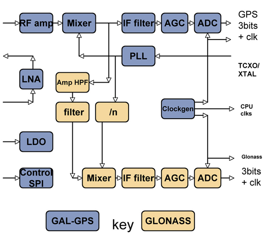
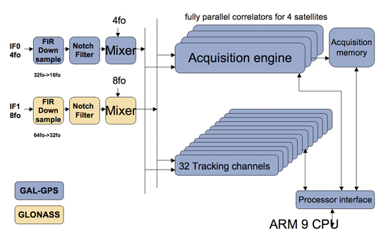
    In the RF section, the LNA, RF amp, and first mixer are shared by both paths, in order to save external costs and pins for the equipment manufacturer, and also to minimize power consumption. Then the GLONASS signal, now at around 30 MHz, is tapped off into a secondary path shown in brown, mixed down to 8 MHz and fed to a separate ADC and thus to the baseband.

    In the baseband, an additional pre-conditioning path is provided, again shown in brown, which converts the 8 MHz signal down to baseband, provides anti-jammer notch filters, and reduces the sample rate to the standard 16fo expected by the DSP hardware.

    The existing acquisition engines and tracking channels can then select whether to take the GPS/Galileo signal, or the GLONASS signal, making the allocation of channels to constellations completely flexible.

    Less visible but very important to the system performance is the software controlling these hardware resources, first to close tracking loops and take measurements, and secondly the Kalman filter that converts the measurements to the PVT data required by the user. This was all structurally modified to support multiple constellations, rather than simply adding GLONASS, in order that future extensions of the software to other future systems becomes an evolutionary task rather than a major re-write.

    The software ran on real silicon in 2010, but using signals from either simulator or static roof antennas, where accuracy and availability of GPS alone are so good that there is little room for improvement. In early 2011, prototype satnav hardware using production chips, antennas, and cases became available, making mobile field trials viable.

    Actual Results

    Results have already been seen from trials using professional receivers with independent GPS and GLONASS measurements. However, those tests were not representative of the consumer receiver because they are not high sensitivity; because the receivers require enough clean signal to operate a PLL, which is not realistic in a mobile city environment; and because they were creating two separate solutions, thus needing a continuous extra satellite to resolve inter-system time differences.

    A 2010 simulation of visible satellites in a typical urban canyon of downtown Milan, Italy, produced the results, every minute averaged for a full 24 hours, shown in Table 1. The average number of satellites visible rises from 4.4 with GPS alone, to 7.8 for GPS+GLONASS, with the result that there are then zero no-fix samples. With GPS alone there were 380 no-fix samples, or 26 percent of the time.

     Table 1. Accuracy and availability of GPS and GPS+GLONASS, averaged over 24 hours. Source: Philip Mattos, STMicroelectronics R&D Ltd.
    Table 1. Accuracy and availability of GPS and GPS+GLONASS, averaged over 24 hours.

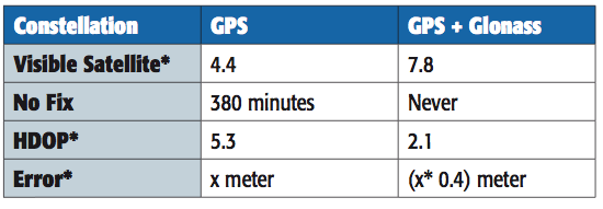
    However, availability is not itself sufficient. Having more satellites in the same small piece of sky above the urban canyon may not be sufficient, due to geometric accuracy limitations. To study this, the geometric accuracy represented by the HDOP was also collected, and shows an accuracy 2.5 times better.

    Previous studies suggested that in the particular cities tested, two to three additional satellites were available, but one of these was wasted on the clock solution. Using the high-sensitivity receiver, we expected four or five extra satellites and none wasted.

    The actual results far exceeded our expectations. Firstly, many more satellites were seen, as all previous tests and simulations had excluded reflected signals. Having many more signals, the DOP was vastly improved, and the effect of the reflections on accuracy was greatly reduced, both geometrically, and by the ability of the FDE/RAIM algorithms to maintain their stability and down-weight grossly erroneous signals rather than allow them to distort the position.

    The results presented here are from a fully integrated high-sensitivity receiver optimized to use signals down to very low levels, and to give a solution derived directly from all satellites in view, no matter which constellation.

    This produces 100 percent availability, and much improved accuracy in the harsh city environment.

    Availability

    The use of high-sensitivity receivers, not dependent on phase-locked loops (PLLs) for tracking, produces 100 percent availability in modern cities, even high-rise, due to the reflective nature of modern glass in buildings, even for GPS alone. Thus some other definition of availability is required rather than “four sats available,” such as sats tracked to a certain quality level, resulting in a manageable DOP. Even DOP is difficult to assess, as the Kalman filter gives different weights to each satellite, not considered in the DOP calculation, and also uses historic position and current velocity, in addition to instantaneous measurements, to maintain the accuracy of the fix.

    Figure 3 shows the availability of tracked satellites in tests in the London City financial district in May 2011.

    figure3 Source: Philip Mattos, STMicroelectronics R&D Ltd.

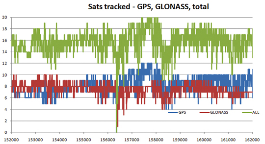
    As can be seen, there are generally seven to eight GLONASS satellites and eight to nine GPS satellites, for a total of around 16 satellites. The only period of non-availability was in a true tunnel (Blackfriars Underpass) at around time 156400 seconds. In other urban canyons, around time 158500 and 161300, individual constellations came down to four satellites, but the total never fell below eight. Note this is an old city, mainly stone, so reflections are limited compared with glass/metal buildings.

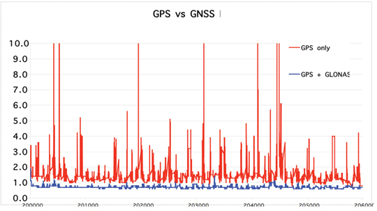
    While outside tunnels, availability is 100 percent, this may be limited by DOP or accuracy. As can be seen in Figure 4 on another London test, the GNSS DOP remains below 1, as might be expected with 10–16 satellites, while GPS-only frequently exceeds four, with the effect that any distortions due to reflections and weak signals are greatly magnified, with several excursions over 10.

     Figure 4. GPS-only versus combined GPS/GLONASS dilution of precision. Source: Philip Mattos, STMicroelectronics R&D Ltd.
    Figure 4. GPS-only versus combined GPS/GLONASS dilution of precision.

    As the May 2011 tests had not been difficult enough to stress the GPS into requiring GNSS support, a further trial was performed in August 2011. This was in a modern high-rise section of the city, Canary Wharf, shown in Figure 5 on an aerial photograph. In addition to being high-rise, the roads are also very narrow, resulting in very difficult urban canyons. Being a modern section of the city, the buildings are generally reflective glass and metal, rather than stone, testing RAIM and FDE algorithms to the extreme.

     Figure 5. GPS versus GNSS, London Canary Wharf (click to enlarge.) Source: Philip Mattos, STMicroelectronics R&D Ltd.
    Figure 5. GPS versus GNSS, London Canary Wharf (click to enlarge.)

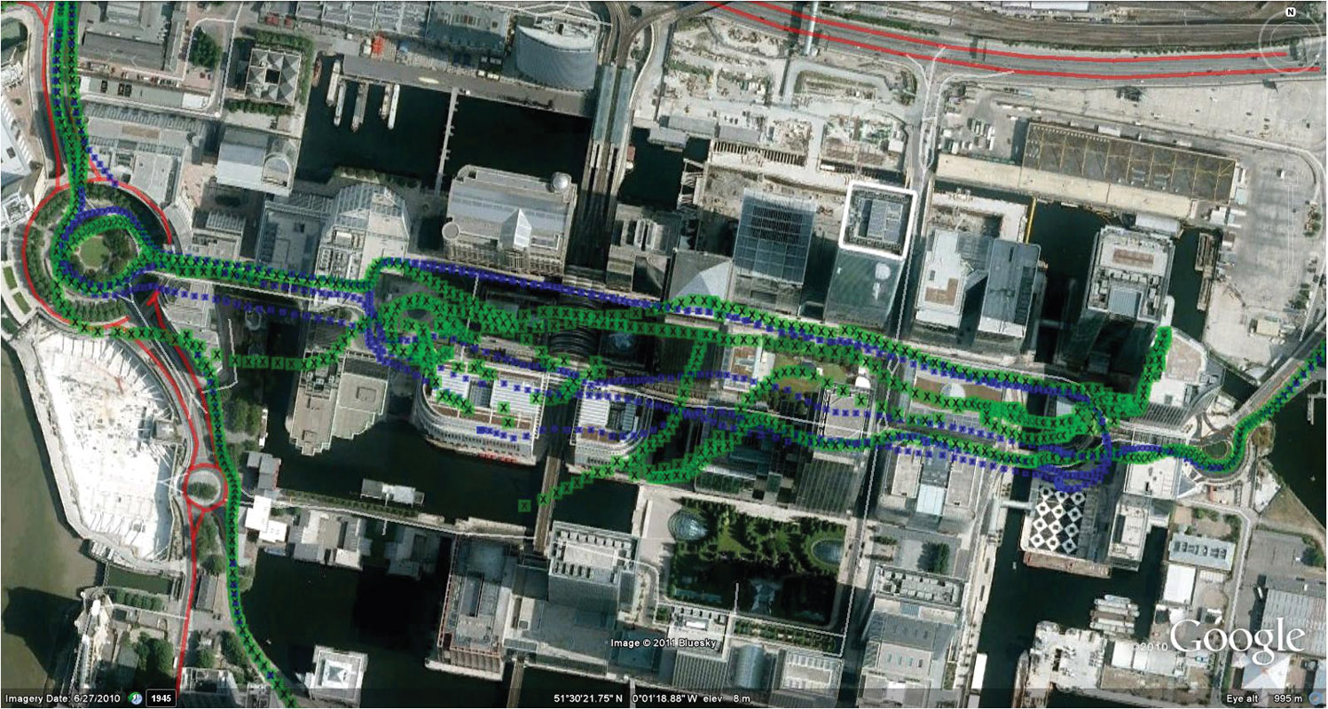
    This resulted in difficulty for the GPS-only solution, shown in green, especially in the covered section of the Docklands station, center-left, lower track.

    Figure 6 shows the same test data displayed on truth data taken from the ordnance survey vector map data of the roads.

     Figure 6. GPS versus GNSS, London Canary Wharf, on vector truth (click to enlarge.) Source: Philip Mattos, STMicroelectronics R&D Ltd.
    Figure 6. GPS versus GNSS, London Canary Wharf, on vector truth (click to enlarge.)

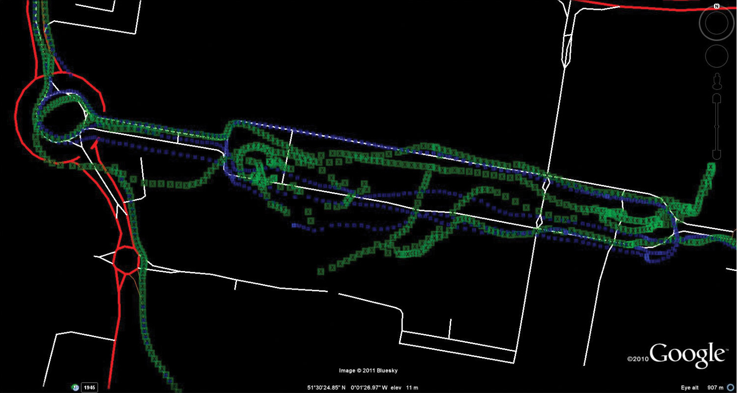
    The blue GNSS data is then extremely good, especially on the northern (eastbound) part of the loop (UK drives on the left, thus one-way loops are clockwise).

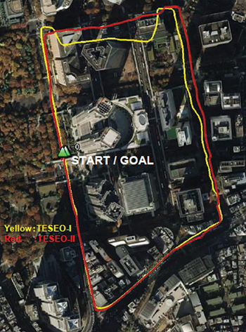
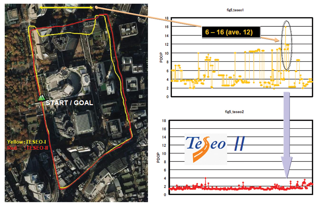
    Further tests were carried out by ST offices around the world. Figure 7 shows a test in Tokyo, where yellow is the previous generation of chip with no GLONASS, red was Teseo-II with GPS plus GLONASS.

     Figure 7. Teseo-I (GPS) versus Teseo-II (GNSS) in Tokyo test. Source: Philip Mattos, STMicroelectronics R&D Ltd.
    Figure 7. Teseo-I (GPS) versus Teseo-II (GNSS) in Tokyo test.

    Again, here the scenario is not sufficiently challenging to hurt the availability even of GPS alone, but the accuracy is limited.

    Figure 8 gives some explanation of the accuracy problems, by showing the DOP during the test. It can be seen that Teseo-II DOP was rarely above 2, but the GPS-only version was between 6 and 12 in the difficult northern part of the test, circled for illustration.

     Figure 8. DOP during Tokyo tests (click to enlarge.) Source: Philip Mattos, STMicroelectronics R&D Ltd.
    Figure 8. DOP during Tokyo tests (click to enlarge.)

    Further Tokyo tests were performed entering the narrower urban canyons in the same test area, shown in Figure 9. Blue is GPS only, red is GPS+GLONASS, and the major improvement is obvious.

    Figure 9. GPS only (blue) versus GNSS (red), Tokyo. Source: Philip Mattos, STMicroelectronics R&D Ltd.
    Figure 9. GPS only (blue) versus GNSS (red), Tokyo.

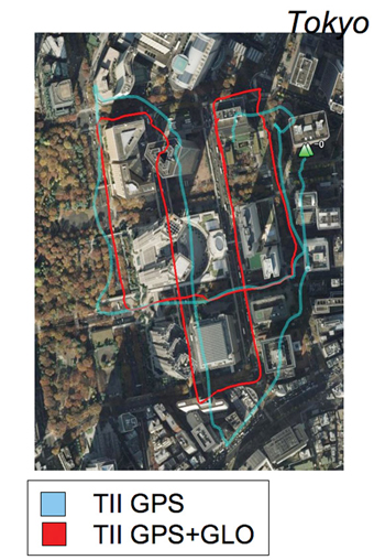
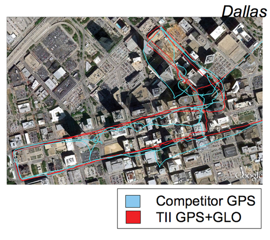
    Figure 10 uses the same color scheme to illustrate tests in Dallas, this time with a competitor’s GPS receiver versus Teseo-II configured for GPS+GLONASS, again a huge benefit.

     Figure 10. GPS only (blue, competitor) versus GNSS (red), Dallas.
    Figure 10. GPS only (blue, competitor) versus GNSS (red), Dallas.

    Other Constellations

    While Teseo-II hardware supports Galileo, there are no production Galileo satellites available yet (September 2011), so the units in the field do not have Galileo software loaded.

    However, the Japanese QZSS system has one satellite available, transmitting legacy GPS-compatible signals, SBAS signals, and L1C BOC signals. Teseo-II can process the first two of these, and while SBAS is no benefit in the urban canyon as the problems of reflection and obstruction are local and unmonitored, the purpose of QZSS is to provide a very high-angle satellite, so that it is always available in urban canyons.

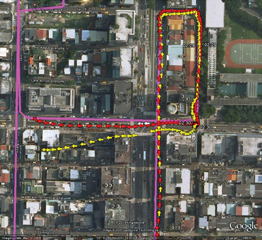
    Figure 11 shows a test in Taipei (Taiwan) using GPS (yellow) versus GPS plus one QZSS satellite in red, with the truth data shown in purple.

    figure11_B Source: Philip Mattos, STMicroelectronics R&D Ltd.
    Figure 11. GPS only (yellow) versus GPS+QZSS(1 sat, red), truth in purple, Taipei (click to enlarge.)

    Further Work

    The test environment will be extended to yield quantitative accuracy results for UK tests where we have the vector truth data for the roads.
    The hardware flexibility will be extended to support Compass and GPS-III (L1-C) signals, in addition to Galileo already supported. Acquisition and tracking of these signals have already been demonstrated using pre-captured off-air samples.

    In 2010, the Compass spec was not available. Thus the Teseo-II silicon design was oriented to maximum flexibility in terms of different code lengths, such as BOC or BPSK, so that by using software to configure the hardware DSP functions, the greatest chance of compatibility could be achieved.

    The result was only a marginal success, in that the 1561 MHz frequency of the regional Compass system can only be supported using the flexibility of the voltage-controlled oscillator and PLL, meaning that it cannot be supported at the same time as other constellations. Additionally, the code rate on the regional system is also 2 M chips/second, which is not supported, so is approximated by using alternate chips, producing serious signal loss.

    So the hooks for Compass are only useful for research and software development, either for a single-constellation system, or using a separate RF front end.

    The worldwide Compass signal, which is on a GPS/Galileo signal format in both carrier frequency and in code length and rate, will be directly compatible, but is not expected to be fully available until 2020.

    The city environment testing will be repeated as the Galileo constellation becomes available. With 32 channels, an 11/11/10 split (GPS/Galileo/GLONASS) may be used when all three constellations are full, but for the next few years 14/8/10 satisfies the all-in-view requirements.

    Conclusions

    The multi-constellation receiver can include GLONASS FDMA at minimal increased cost, and with its 32 channels tracking up to 22 satellites in a benign environment, even in the harshest city environment sufficient satellites are seen for 100 percent availability and acceptable accuracy. 10–16 satellites were generally seen in the urban canyon tests. The multiplicity of measurements allows RAIM and FDE algorithms to be far more effective in eliminating badly reflected signals, and also minimizes the geometric effects of remaining distortion on the signals retained.

    Acknowledgments

    ST GPS products, chipsets, and software, baseband and RF are developed by a distributed team in Bristol, UK (system R&D, software R&D); Milan, Italy (silicon implementation, algorithm modelling and verification); Naples, Italy (software implementation and validation); Catania, Sicily, Italy (Galileo software, RF design and production); and Noida, India (verification and FPGA). The contribution of all these teams to both product ranges is gratefully acknowledged.


    Philip Mattos received a master’s degree in electronic engineering from Cambridge University, UK, a master’s in telecoms and computer science from Essex University, and an external Ph.D. for his GPS work from Bristol University. He was appointed a visiting professor at the University of Westminster. Since 1989 he has worked exclusively on GPS implementations and associated RF front ends, currently focusing on system-level integrations of GPS, on the Galileo system, and leading the STMicroelectronics team on L1C and Compass implementation, and the creation of generic hardware to handle future unknown systems.

  • The Business and Product Showcase — December 2011

    Download the PDF of The Business and Product Showcase sections from the December 2011 issues here.

  • You Say You Want A Revolution?

    After last week’s column, “Technology: Friend or Foe?”, I received a bit of mail. Usually when I write about technology wiggling its way into our lives, the mail I receive is from readers who are apprehensive, concerned, and even frightened of the paradigm shift we are experiencing and going to experience in our lives at the hands of the digital revolution.

    If you think about it, the past 30+ years (1980-2011) really dwarfs the previous 30 year period (1950-1980) in terms of lifestyle changes. With the exception of transportation (automobile/air travel) and some medical advancement, the 1950-1980 period was relatively static and stable. It was commonplace for people to work for the same company for 30 years and retire. In fact, you could even wind the clock back another 10 years to 1940 and not see a drastic change, although World War II was a major focus in the 1940s and did challenge the stability of day-to-day family lifestyles.

    However, the lifestyle changes we have gone through in the past 30 years (even the past 15 years) have been radical. Thanks to the Internet, I haven’t had to commute to an office in more than 10 years. I’m constantly connected to my family, friends and work colleagues with my mobile phone via talk, text, or email. Sometimes, I will go months without writing a physical check to pay a bill.

    The upside is that we are spending less time on mindless “busy work.” Growing up, I recall watching my parents spend a full evening going through canceled checks and bank statements in order to balance their checkbooks. I recall my father making a trip to the bank on Friday afternoon to withdraw cash for the weekend activities (no ATMs). I recall trading a $10 bill for a roll of quarters at the bank in order to make a long distance telephone call back home during my military service days. Back then, there were telephone booths at nearly every street corner. When’s the last time you remember seeing a telephone booth?

    These lifestyle changes are the result of the digital revolution…and it’s just beginning.

    Following is a great blog post from marketing guru Seth Godin called Pre Digital:


    A brief visit to the emergency room last month reminded me of what an organization that’s pre-digital is like. Six people doing bureaucratic tasks and screening that are artifacts of a paper universe, all in the service of one doctor (and the need to get paid and not get sued). A 90-minute experience so we could see a doctor for ninety seconds.

    Wasteful and even dangerous.

    Imagine what this is like in a fully digital environment instead. Of course, they’d know everything about your medical history and payment ability from a quick ID scan at the entrance. And you’d know the doctor’s availability before you even walked in, and you would have been shuttled to the urgent care center down the street if there was an uneven load this early in the morning. No questions to guess at the answer (last tetanus shot? Allergies to medications?) because the answers would be known. The drive to the pharmacy might be eliminated, or perhaps the waiting time would be shortened. If this accident or illness is trending, effecting more of the population, we’d know that right away and be able to prevent more of it… Triage would be more efficient as well. The entire process might take ten minutes, with a far better outcome.

    School is pre-digital. Elections. Most of what you do in your job. Even shopping. The vestiges of a reliance on geography, lack of information, poor interpersonal connections and group connection (all hallmarks of the pre-digital age) are everywhere.

    Perhaps the most critical thing you can say of a typical institution: “That place is pre-digital.”

    All a way of saying that this is just the beginning, the very beginning, of the transformation of our lives.


    Geospatial technology is in the same place. We are being teased with digital geography (GIS), but this is only the initial adoption wave. There is a geography component in nearly every part of our day-to-day lives. The following image captures the adoption of geospatial technology. We are clearly still in the “GIS Professional” part of the curve, and arguably entering the “Application Users” era and clearly on our way to mainstream “Society” adoption.

    Esri International User Conference

    I wrote a column late last year, “Will We Be a Billion Times More Geospatially Intelligent in Thirty Years?” The premise behind it is that geospatial technology will grow exponentially instead of linearly.

    Red = Linear Growth, Blue = Cubic Growth, Green = Exponential Growth (Source: Wikipedia)

    In essence, if you follow the linear model (red line), technology will progress only 30 steps in the next 30 years. With exponential growth (green line), technology will progress a billion times in the next 30 years.

    How much paper are you pushing (pre-digital)? How much inefficiency is in your organization because of a lack of information or geographic (location) awareness? Location awareness isn’t necessarily the location of an outdoor asset (utility pole, manhole, parcel). It could be the location of a document (paper or digital), the location your lymph nodes (medical GIS), or even your key ring.


    Thanks, and see you next week.

    Follow me on Twitter at http://twitter.com/GPSGIS_Eric

  • The Hits and the Misses

    GNSS Design & Test Newsletter, November 2011

    LONDON — Technical conferences usually feature hits: advances in technology, new form factors, improved signal processing. But the opening day of the European Navigation Conference in London has dwelt instead on misses: vulnerabilities, threats, weaknesses that leave GNSS increasingly open to attack and disruption. Gaps in our armor, with scant help in sight.

    The first gloomy note sounded during the opening plenary, usually replete with optimistic constellation updates. Colin Beatty, president of the hosting Royal Institute of Navigation (RIN), noted the first signs of increasing sunspot activity, heralding the oncoming solar maximum, that have caused instances of several minutes of GPS outage at a time around Singapore. Eleven years ago, he remembered, the last solar maximum created outages of four hours daily over an extended period in a Brazilian off-shore drilling area. The current cycle has only just begun.

    This and other types of interference were repeatedly mentioned — LightSquared among them, though not discussed at length — by both speakers and the audience, in questions and comments. Andy Norris, RIN vice-president and conference chair, asked “Why do the governments of this world not seem to be taking seriously the fact of GNSS vulnerability?”

    A representative of the Ireland Lighthouse Authority stated that “The implications of denial of service become more serious with each passing year,” in the sphere of marine navigation, although clearly the remark applies in a much broader, in fact universal context. “Ships are larger, more valuable, they move faster, with smaller crews, and are increasingly reliant on a sole source of positioning and navigation — GPS.”

    When GPS aboard ships was first introduced for navigation, Rein van Gooswilligen of the European Union Group of Institutes of Navigation recalled, it met with some resistance. If you showed a captain a laptop with GPS navigation, they might look at it for five or 10 minutes at a time. Now they are looking exclusively at it, without any supplemental means of navigation, including visual sighting — and other onboard systems have been discontinued.

    An U.S. Navy officer stated that the service is taking a hard, critical look at reliance on GPS, and emphasized the critical timing aspect as well as navigation. The Navy is reconsidering optical navigation including automated optical — and is very interested in a modernized Loran, although the old Loran-C ahs been done away with in the United States.

    “What are we doing wrong or failing to do,” posed Andy Norris again, “ to get our message on vulnerability across to politicians and other key decision-makers?”

    During a coffee break, I got an advance look at possible counter to vulnerability, an integrated eLoran and GPS receiver, smaller than a deck of cards, from Roke Manor Research Ltd. This has great potential for many GNSS-challenged and/or –disrupted environments, and a product should be released soon. That was the one hit of the day.

    Presentations resumed with the largest conference room packed to overflowing for the first of several sessions on interference and jamming. “Spectrum Wars — Give Us This Day Our Daily Bread” was David Last’s chosen title, a paper co-written with Sally Basker, who provided the economic analysis, and one I hope to present in the January issue of GPS World magazine. He calculated the impact on a low-technology product such as bread of the unavailability of high-tech GPS for precision agriculture, transport, and telecoms at every stage of the value chain to show just how pervasive and real a threat to global security it would be if such systems fail or are made to fail. “A dependence on GPS connects many disparate sectors.”

    Last presented the “triple whammy” of denial:

    • Each new satellite in the GPS frequency band also increases the noise level.
    • GNSS nations compete for spectrum.
    • Communication systems compete with GNSS for spectrum.

    And this is not even getting to unintentional RF interference, intentional jamming, and spoofing, he pointed out.

    Intensely political spectrum wars increase GNSS vulnerability, he concluded, and ominously reminded us that the trigger of the French Revolution was . . . an increase in the price of a loaf of bread.

    Durk Van Willigen of Reelektronika began the next talk by stating, “My presentation won’t make you very happy.” He allowed as how the LightSquared battle was fascinating to observe — especially by non-U.S. countries — and should have been expected. There will be more of them, he said.

    “Once upon a time, spectrum was like oil and gas: we had more than we needed.” No more. There’s “No Escape!” he warned, and he pointed out that, on a business basis, GPS and other GNSS spectrum use is free (paid through taxes), while telecommunications companies must pay for spectrum licenses. “As more spectrum will be needed for communication, the pressure on GNSS spectrum is enormous and will increase. Reducing this financial imbalance,” he proposed, “makes GNSS politically more convincing in its spectrum claims.”

    “All the conditions for a gold rush are present,” he concluded, alluding to the frantic grabs that characterize such phenomena. “GNSS — pay for it, or shrink your spectrum need. Be aware and prepare for the next attack.”

    Carl Milner of Imperial College London and Andy Proctor of Chronos Technology then took up the pragmatic, doing side, and even generated a few near-hits, with talks on the GAARDIAN and SENTINEL projects, respectively. GAARDIAN has largely concluded its three-year run to deliver prototype sensors and probes to detect interference and give alarms, as well as detailed analyses of the GNSS environment.  Milner reminded us that 800 billion (British pounds or euros, nearly equivalent at this point), or 6 to 7 percent of Western Europe’s annual gross domestic product, is dependent on GPS. That means 94 billion pounds in the UK, rising yearly.

    The British economy (and by implication the European, U.S., and global economies) is vulnerable, by this dependence, to interruption of the energy supply, breakdown of communications, transport, and financial services, and potential loss of life  — all with no operational monitoring, detection, recourse, or back-up, prior to GAARDIAN and SENTINEL.

    The follow-on SENTINEL is mid-way through its two-year life to take the next requisite steps:

    • Actually locating the interference;
    • categorizing it;
    • determining its extent;
    • giving a determination of trust in GNSS,
    • and addressing spoofing.

    The project has a large user base in law enforcement and government.

    The gloom kept descending like London fog with an after-lunch roundtable discussion on “Threats and Vulnerabilities of GNSS Signals,” moderated by Vidal Ashkenazi of Nottingham Scientific Ltd. A few direct quotes from the speakers, even without specific context provided, should give the flavor of the discussion.

    Tim Just, UK Technology Strategy Board. “Consider the motivation of jamming first: is it in relation to privacy or personal choice, or to criminality? There is perhaps a third case, the hacker community, with intent to disrupt. It is very difficult to quantify those today.  Projects like GAARDIAN and SENTINEL, neither with full national coverage, are only just now starting.

    “There is a choice: remove the jammers, or use other technologies to counter the jamming.  The latter is very expensive, and not available to civil market at the moment.”

    Captain Frank Parker, U.S. Coast Guard. “The recent change to U.S. policy, enabling government agencies to use foreign GNSS services is a very important first step [in combatting jamming and interference].

    “A key factor in determining whether the loss of PNT is due to an external factor, or if it could be something inherent in the receiver, is that the multiple international service providers of GNSS share information about the status and health of their constellations.

    Professor Ashkenazi’s second main question, “What is the additional likely contribution of the Public Regulated Service (PRS) of Galileo?” elicited these responses, much encapsulated here.

    Stefan Baumann, IABG GmbH. “We will get improved signal availability with multi-GNSS, but not such improvement in robustness.  M-code and PRS can help; But M-code restricted to military, so PRS is the way for civil user.”

    Captain Parker. “Market forces drove elimination of other redundant technologies in the past. Market forces will determine the success, or not, of PRS, with its new market cost. In the United States, as the standard positioning service of GPS improved over the years, some users of high-precision services dropped off [and relied just on SPS].  The determining factor is not only cost, but also ease of use.

    Michel Bosco, European Commission. “We are convinced about the added value, especially because of its robustness, of PRS.  We are engaged in discussions with user communities on this. We are planning on users being able to adopt the technology as soon as it is there.”

    Stefan Baumann.  “The courts in Germany have interest in GNSS data which is 100 percent proof against spoofing.”  (Thus PRS.)

    One emerged from the conference — and yes, it is indeed raining in London now — feeling as if one were wearing, not so much a badly chinked suit of armor, but a set of the emperor’s new clothes.

  • Galileo IOV Satellites Reach Operating Orbits

    News from CANSPACE Listserv.

    An announcement from ESA on November 4 stated "Europe’s first two Galileo IOV satellites have reached their final operating orbits, opening the way for activating and testing their navigation payloads." But, based on NORAD/JSpOC tracking of the satellites, it seems that the final orbits were achieved only a day or so ago.

    The plot above (and linked here) shows the mean motion (mm) of the PFM and FM2 satellites since launch. As evidenced by the lengthy gaps in the mm history, it is clear that NORAD/JSpOC sometimes has difficulty in reacquiring satellites after delta-V manoeuvres. We do know, however, that both satellites have appeared to reach their final orbits sometime between November 19 and 23. The mm values are now very close to the value 1.7046556 orbits per day derived from the mean semimajor axis of the Galileo constellation as given in the Galileo Open Service Signal-In-Space Interface Control Document: 29601.297 km.

    The arguments of latitude of the two satellites, essentially in the same orbit plane, are now 40 degrees apart as intended. There have not been any public reports that navigation signals from the satellites have yet been switched on.

  • Technology: Friend or Foe?

    More than 20 years ago, I was tasked with training a group of foresters to use new field data collection technology that would require them to change their field procedures. Needless to say, most of them vehemently opposed the change. Even with pressure from the organization to adopt the technology, some continued to rebel to the point that they would use their legacy methods (pencil/paper) in the woods, only to return to their truck and enter the data from the paper to the handheld data recorder.

    I admit it, I hate to change too.

    In fact, my notebook computer is way past its retirement age (four years old). The sound doesn’t work any more, some screen pixels don’t work, the battery lasts abut 45 minutes, and it’s running Windows Vista. I’ve actually bought another notebook computer, but haven’t made the transition. The pain of trying to find all of the software installation CDs, etc. of all the software I have on this computer is still greater than the pain of no sound, a so-so screen, and a lousy battery. So, I carry two notebook computers with me when I travel. It’s pretty sad.

    Sometimes we don’t have the luxury of choice and we are forced to change. Today’s world is not what it was when I was growing up. It’s changing, and it keeps changing. My father worked for the same organization for 30+ years. We had dinner every evening at 5:30 p.m. when we all sat around the dinner table. That’s the life I knew. Set it on cruise control and enjoy the ride.

    However, that way of life is over. It was great while it lasted, but I doubt it will ever exist again.

    At 24, after my four-year stint in the U.S. Air Force and picking up my college degree, my first job out of college was at a high-technology start-up company. At the time, I had no clue how that experience would help prepare me for today’s economy.

    As many of you know, at a small company (especially a start-up in the high-technology industry) it’s all about getting the job done. Pulling all-nighters, working through lunch, and working 12-hour days is a regular part of life. “Whatever it takes” is a common phrase. The concept of comp time, sick days, and even vacation days (at times), are luxuries only enjoyed by others. On more than one occasion, I watched my vacation days evaporate on December 31. It’s not a particularly healthy lifestyle if you don’t pay attention to work/family balance.

    However, it did prepare me for the harsh reality of the new economy, one in which job security is minimal and one in which you need to prove your worth on a weekly basis, making it tough to avoid pulling your weight, and some extra. In short, one needs to bring their “A” game every week.

    I’ve spoken with many, many people who dream about “the way things used to be.” They say it was an easier and less stressful time, and they generally hold a negative view of technology because they feel it has cost jobs. They say that computers have replaced people.

    I agree, it was an easier and less stressful time. However, I submit that pressure and stress forces us to find more creative and innovative solutions. Walter Isaacson’s biography of Steve Jobs is the #1 non-fiction best seller, according to the New York Times. It’s clear that Jobs produced some of the most innovative and successful products and services of our time. Yet, he created a highly stressful and uncomfortable work environment. Emotional outbursts and “on-the-spot” firings were not unusual and directed at those who weren’t producing at the level Jobs deemed essential. Obviously, it wasn’ t the healthiest environment, but is there a better way to squeeze the highest performance from people?

    It reminds me of a quote from Tom Landry, who for many years was the coach of the Dallas Cowboys professional football team. He said “Leadership is getting someone to do what they don’t want to do, to achieve what they want to achieve.”

    Reading that statement makes me think back to the group of foresters I mentioned above. None of them wanted to change. They really didn’t see the benefit of the electronic devices over their proven pencil/paper technology. They thought it was great for the data processing folks who didn’t have to transcribe the paper notes any longer, but thought the field foresters were the ones who were paying the price by hauling around the handheld devices. Eventually, they succumbed to the technology and it became the “new normal.” Years later, many of them told me that they eventually tossed out their pencil/paper and couldn’t imagine going into the woods without their handheld computer. I’m sure there were a few die-hards who bought enough time until their retirement to avoid the pain of change, but the others had no choice to transition to the electronic age.

    One of the major changes the world is facing today is geography. With respect to our profession, digital geography (GIS) has a tremendous amount of upside. It’s not just a tool for scientists any longer. Digital geography in everyone’s lives is becoming more ubiquitous, from GPS navigation systems in your car to different location-based services (LBS) apps on your mobile phone.

    On the other hand, physical geography is working against some industries. It used to be that having a “local office” allowed companies to charge a premium for their service. Before the Internet revolution, how did you buy an airline ticket? When’s the last time you visited a travel agent? What happened to travel agencies? Whereas they had a valuable geographic advantage that linked the services providers (airlines, cruise lines, hotels, rental cars, etc.) to the consumer, that advantage disappeared almost overnight with the Internet revolution. At the end of the day, 90 percent of the travel agencies didn’t offer enough value beyond the geographic advantage to justify their existence.

    Think about other industries that rely on physical geography to justify their existence. Realtors, insurance agents, etc. I just recently dumped Allstate as my automobile insurance provider and signed up with GEICO. Allstate has a local agent, or three. GEICO doesn’t, as far as I know. Do I care? No. In the five or so years I was with Allstate, I don’t remember ever meeting the agent. He’s doing a disservice to Allstate and to himself. He’s made himself insignificant.

    That’s really what it boils down to in this economy. How much value do you bring to your organization? If you call in sick tomorrow, does anyone care? Have you made yourself valuable enough to your organization that they can’t afford to let you go?

    Recently, one of my Facebook friends posted a quote from George Monbiot. I don’t know if it is an original quote of his or not, but here goes.

    “If wealth was the inevitable result of hard work and enterprise, every woman in Africa would be a millionaire.”

    It’s really not about how hard you work. Most of us probably couldn’t keep up with the woman in Africa Monbiot is referring to with respect to hard work. It is about what you bring to the table. If your best skill is possessed commonly by others, then you’re relatively insignificant. That translates into poor job security and low pay. If you are indespensable to your organization, it will go out of its way to keep you employed and likely pay you what you are worth.

    Like it or not, the world economy is not going to return to what it used to be. We had one heck of a run starting with the industrial revolution. The 30+-year career like my father had is a rarity instead of the norm. Careers will be dynamic, moving from project to project. The more unique your skillset is, the better choice of projects you’ll have.

    Last week, I was traveling  and stopped by one of the golf course projects I’m involved in. The club hired a new assistant superintendent (greenskeeper). He is a very recent college graduate. Most golf course superintendents like to be outdoors instead of driving a desk. As a result, many of them aren’t technology savvy, especially when it comes to GIS and GPS technology. After spending a couple of hours with him, he picked up the concept and operation of the tree mapping system quite well. Then his mind started working and he started asking me about other things he could do with the system (mapping irrigation, drainage, greens, etc.). I suggested that if he could master this technology, he’d be a step ahead of the crowd in his chosen profession.

    “Yep,” he said, “one more thing to add to my resume.”

    He probably didn’t understand how profound that statement was.

    Thanks, and see you next time.

    Follow me on Twitter at http://twitter.com/GPSGIS_Eric

  • LightSquared: Five Questions of My Own

    In true Wall Street lawyer fashion, LightSquared Executive VP Jeff Carlisle thinks he’s entitled to receive answers with regards to LightSquared’s GPS-jamming problem instead of providing answers. He seems to forget that LightSquared is the one applying for approval to proceed, and needs to provide the answers and solutions.

    Interestingly enough, LightSquared’s questions really point out how ignorant the company continues to be about the GPS industry, which is surprising since it’s been about a year since it submitted its application to the FCC. By now, you’d think that the company would have performed enough due diligence to become familiar with the GPS industry. From the questions for which it demands answers, apparently not.

    First of all — I’ve written before and I’ll write it again — the GPS user community is in its own corner on this issue. No one is looking out for your interest unless you are able to persuade your congressperson to act on your behalf.

    Incidentally, I spoke to a state legislator last week who reached out to me about the LightSquared GPS-jamming issue. He was one of those legislators who had submitted a letter of support for LightSquared to the FCC during the public comment period. He said that LightSquared lobbyists were reaching out again last week to state legislators looking for letters of support. He said he didn’t know anything about the technology but believed LightSquared’s claims of 15,000 jobs being created. What he didn’t understand was the chaos it would cause to the economy with respect to small business (agriculture, engineering, construction), fed/state/local government, aviation, and military. Of course, once he understood the full impact, he made it clear that he would not approve of a system that would have a negative impact on GPS. When I informed him that there’s a solution being floated by LightSquared (the “fix”), but that it is yet to be vetted and that the upgrade cost would run into the billions, he concluded “we can’t afford it.”

    I think this is a typical situation among legislators and other public officials who have voiced their support for LightSquared. They just don’t understand the issue and take what LightSquared lobbyists say at face value. Once it’s explained to them, they quickly understand that America can’t afford LightSquared’s current proposal.

    Speaking of lobbyists, if you didn’t watch “60 Minutes” on November 6, take a look the following video on the corruption taking place in the U.S. Congress. It’s disgusting.

    Now, back to the subject at hand.

    Yes, Trimble, Deere/Navcom, Garmin, and other GPS manufacturers are putting up a good fight via the Coalition to Save Our GPS. They’ve invested tens of millions, if not more than $100 million, in this debate over the last year, largely on behalf of and in support of the GPS user community. But make no bones about it, if LightSquared is granted approval to proceed, and that action requires your equipment to be upgraded (if an upgrade is even possible), this will be a huge windfall for the GPS manufacturers. They will make a ton of money. Salespeople will sit back and take orders. There’s no easier business than a forced upgrade (do you remember the Y2K problem?).

    That brings us to LightSquared’s first question to which it demands an answer.

    LightSquared Question #1: Isn’t it true that the so-called “non-biased” PNT Advisory Board, which advises the Pentagon, is represented by board members of GPS companies who have a financial stake in LightSquared not getting approval to proceed?

    They are referring primarily to Dr. Brad Parkinson, who has been a Trimble board member for many years, and who even acted as Trimble CEO for a period of time, more than a decade ago, after Charlie Trimble’s departure.

    Dr. Parkinson is an aeronautical engineer. He’s retired from the U.S. Air Force (at the rank of colonel) and is a professor emeritus at Stanford University. He was the first GPS Program Manager for the U.S. Air Force, and is largely responsible for the GPS getting on the road to being what it is today.

    LightSquared’s question implies that Dr. Parkinson, a Trimble shareholder and board member who has voiced his opposition to the LightSquared initiative, will somehow profit if LightSquared’s application is rejected by the FCC.

    If LightSquared personnel put some thought into it, they’d understand that Trimble (and its shareholders) stand to make a lot more money if LightSquared is allowed to proceed than if it isn’t. In other words, if LightSquared is allowed to proceed, Trimble makes a ton of money in forced upgrades from GPS users who hadn’t planned on it.  If LightSquared isn’t allowed to proceed, Trimble has just spent a year and ~$25 million (my estimate) in direct and indirect costs participating in this fire drill, not to mention the opportunity cost of the distraction of high-level engineers and executives.

    For example, the company/entity/individual who just bought the latest and greatest Belchfire XYZ GNSS receiver six months ago would face   an upgrade charge of thousands because it needs a new circuit board and a new antenna or antenna element. This would be gravy for Trimble because it’s revenue they thought they’d never see for a long time from a customer who just bought the receiver six months ago.

    Again, this assumes a technical fix is possible. That hasn’t been proven yet.  Far from it.

    LightSquared Question #2: Numerous annual reports and SEC filings from GPS manufacturers going back to 2001 acknowledge material harm to their business due to interference with neighboring spectrum. Why did you not prepare your devices with filters if you’ve known for ten years there would be interference problems caused by your devices looking into adjacent spectrum?

    Ok, for how long does LightSquared want to continue ignoring the fact that LightSquared and its predecessors (Skyterra, MSV) encouraged GPS receiver manufacturers to design GPS receivers that “look” into the MSS spectrum?

    Why would LightSquared and its predecessors encourage this?

    The answer? Because LightSquared and its predecessors sell satellite data communications services to the GPS industry using the MSS spectrum (via OmniSTAR), generating tens of millions of dollars in revenue from LightSquared and its predecessors.

    Now, if LightSquared chooses not to sell those satellite data communication services to the GPS industry any longer, that’s the company’s choice, but don’t blame the receiver because it was designed to receive LightSquared’s satellite data communication service it was promoting. That sort of logic is, well, illogical.

    LightSquared Question #3: True or false? Did the GPS industry manufacture devices knowing there would be interference with neighboring spectrum because this enhanced their performance?

    False. LightSquared promoted GPS receivers be designed to access the MSS spectrum in order to access its satellite data communication services that it sells to the GPS industry. Furthermore, LightSquared profited from it.

    LightSquared Question #4: Who funds the Coalition to Save Our GPS?

    I don’t know. Who cares? Certainly not Friends of LightSquared. Can you really not figure that out?

    LightSquared Question #5: Did the GPS industry falsely claim that it would take billions of dollars and more than a decade to find a solution to this problem?

    I don’t know who made this statement, but it wasn’t me.

    I do believe that LightSquared has no clue as to the extent of the negative economic impact its proposed system will cause — and it doesn’t care. The $50 million the company has pledged to repair damage it creates to federal government GPS users constitutes a sliver of what it will actually take.

    But all of this is moot until any sort of proposed “fix” is fully understood and vetted across all product lines and markets. Clearly, LightSquared does not understand the extent of the problem its system causes; otherwise it would have never predicted an FCC decision by the end of this year.

    My Questions

    I was offered the opportunity to interview LightSquared a few months ago. I declined. It’s senseless to speak to a lawyer or marketing guy about this technology. They don’t know what they are talking about. They just regurgitate the same senseless spin.

    But, given that they keep ignoring the fact that they sell satellite data communications services to the GPS industry utilizing the MSS spectrum, I’d pose these questions:

    Question #1 to LightSquared: True or false, does LightSquared sell satellite data communication data services to the GPS industry via frequencies in the MSS spectrum (1525-1559MHz)?

    Question #2 to LightSquared: True or false, did LightSquared’s predecessors, Skyterra and MSV, sell satellite data communications services to the GPS industry via frequencies in the MSS spectrum (1525-1559MHz)?

    Question #3 to LightSquared: When did LightSquared and its predecessors (Skyterra/MSV) first begin selling satellite data communication services to the GPS industry via frequencies in the MSS spectrum (1525-1559MHz)?

    Question #4 to LightSquared: How much gross revenue, in total, has LightSquared and its predecessors (Skyterra and MSV) generated from the GPS industry since they began selling said services to the GPS industry via frequencies in the MSS spectrum (1525-1559MHz)?

    Question #5 to LightSquared: List all of the frequencies in the MSS spectrum that LightSquared and its predecessors (Skyterra and MSV) have utilized in delivering satellite data communication services to the GPS industry since LightSquared/Skyterra/MSV began selling said services?

    Let’s see if LightSquared is as bold in answering questions as they are in asking.

    Thanks, and see you next time.

    Follow me on Twitter at http://twitter.com/GPSGIS_Eric


  • The Good, the Bad, and the Really Ugly

    The Good, the Bad, and the Really Ugly

    The Good

    This month there is good news — great news, actually — where GPS and PNT (Position, Navigation and Timing) systems are concerned. On October 22, a Russian Soyuz rocket placed in orbit the first two validation satellites, built by EADS Astrium Germany, in the Galileo PNT constellation after making its maiden launch from Kourou. Don’t confuse these recent satellites with the earlier experimental satellites, GIOVE-A launched in 2005 followed by GIOVE-B launched in 2008. These initial satellites served to preserve the Galileo ITU frequency filings and test the first-ever space borne Hydrogen Maser atomic clock, which by all accounts is proving to be extremely accurate.

    21102011-_SCO3184-W-1
    The Soyuz launch of two Galileo IOV satellites.

    While it is interesting the Europeans decided on a Russian vehicle for the first Galileo dual launch, the U.S. recently pinned its hopes on a European Ariane Five (pictured at right) to launch a commercially hosted U.S. government payload known, appropriately enough, as the “Commercially Hosted Infrared Payload” or CHIRP sensor, which was specifically developed by the U.S. government as a test payload to test both the payload sensor capability and the commercially hosted options for sensor payloads in GEO. The CHIRP sensor features a fixed telescope that can view one quarter of the Earth from geosynchronous orbit. So it appears that hosted payloads and international launch cooperation efforts are growing and are apparently working successfully.

    The two newest Galileo satellites deployed four hours after the Soyuz rocket lifted off from Kourou, in French Guiana.

    The Soyuz launched the first two of four validation Galileo satellites designed to validate the Galileo concept by testing both space and ground operations. Two additional validation satellites are scheduled to follow in the summer of 2012. Once the In-Orbit Validation (IOV) phase is completed, an additional 12 satellites will be launched to reach an Initial Operational Capability (IOC) of 16 satellites sometime in 2014, and that date looks extremely doubtful.

    According to our own Richard Langley, “During initial operations, the [Galileo] satellites will be controlled by a joint ESA and CNES French space agency team in Toulouse, France. Once that week-long phase ends, the satellites will be handed over to the Oberpfaffenhofen Galileo Control Centre near Munich, [Germany], operated by the DLR German Aerospace Center, which will be responsible for routine operations. Operating the satellite payloads to provide navigation services will be the task of the Fucino Control Centre, near Rome, operated by Telespazio.”

    Now, does that sound like a confusing and expensive ground support system? Everybody and every country insist on their piece of the pie, regardless of efficiency and continuity of operations. Who knows this might work; only time will tell.

    The approximately $7.5 billion Galileo constellation will eventually, hopefully, comprise a retinue of 27 operational satellites with three on orbit spares by 2020.

    The PNT business is obviously good for the Russian launch business. Russia successfully launched a GLONASS-K1 test satellite back in February, followed by three GLONASS-M satellites this month into a constellation that finally, after 29 years, accounts for 23 operational and three hopefully soon-to-be operational satellites. The first operational GLONASS-K1 is not scheduled to be launched until sometime early in 2012. GLONASS satellites have historically proven to be fragile affairs with extremely short lifespans; it remains to see how long this number and capability will be maintained. Hopefully the new K1 and M generation GLONASS satellites have resolved many of the longevity issues. Only time will tell when and if the Russian GLONASS will ever regain Full Operational Capability (FOC), which requires 24 simultaneously operating satellites. The Russians were briefly FOC in December 1995, but unfortunately only for a few months. The word “simultaneous” is important as Russian scientisst frequently state they have 25 or 27 GLONASS satellites in orbit, but unfortunately only 22 or 23 of them are operating. But it is possible, miracles still happen, that by the time you read this GLONASS may actually legitimately have achieved FOC once again.

    Now on the Boeing IIF side of the house, more good news as it was announced this week that the second IIF satellite (IIF-2), which has been operational with an elevated signal strength for several months, now has its signals back within the specified signal strength and is good to go. GPS IIF-3 was originally scheduled for launch this coming summer, but the latest launch schedules show the launch in September 2012, about 11 months from now. With 30+ operational GPS satellites on orbit plus residuals, hopefully this will be soon enough.

    Apple & GLONASS

    Always betting on the come, we now know that the late genius Steve Jobs directed his enterprising engineers to include GLONASS PNT software in the latest iPhone 4S; the latest version iPhone that sold 1.3 million units in one day. This effectively gives the iPhone 55 potential satellites to choose from for PNT information as well as the Wi-Fi, cellular tower, and SkyHook Wireless PNT information. With the addition of the GLONASS PNT resources, the iPhone may now well be the most versatile and capable general-purpose PNT platform that exists today. Is that a sad commentary for other GPS and mobile phone providers, a marketing challenge, or merely a positive sign of the technologically advanced times in which we live? It may in fact simply be a true reflection of the capabilities of the most recognized and profitable corporation in the world today. Apple is doing many things right, and one of them is listening to the consumer and giving them more than they expect. Consequently, customers are loyal and Apple Inc. surpassed Microsoft in market capitalization in 2010, and in 2011 became the most valuable consumer-facing brand in the world. Apple is a company Fortune magazine has named the most admired company in the United States for the last three years running. Apple iPhones and numerous PNT applications are certainly in use by thousands of our warfighters in and out of theater. Interesting, to say the least, plus food for thought and a topic for a future column.

    The Bad

    The bad news not surprisingly comes via the U.S. government and no, it is not about LightSquared, because that situation continues to be worse than merely bad. No, the bad news comes in the form of a recently released but curiously out-of-date publication concerning GPS by the Congressional Budget Office (CBO).  In late October 2011, the CBO released a publication entitled The Global Positioning System for Military Users: Current Modernization Plans and Alternatives.

    I was unfortunate enough to receive both a soft and hard copy; and to make matters worse I don’t own a parakeet. The good news is we do have several fireplaces in our home and winter is rapidly approaching. Truthfully, the report is that bad and out of date, but at least it is boring and long. Fortunately hardly anyone is likely to actually endure the pain and suffering required to read through the entire document. However if you are a masochist and/or suffering from acute insomnia I highly recommend this CBO report as a possible cure. Some of you might justifiably complain I have no business giving medical advice because I am not a medical subject matter expert (SME) and I wholeheartedly agree, just as I agree that the CBO is definitely not a GPS SME and should stay with what they do know. Whatever that is.

    I can assure you when and if the military needs advice concerning future GPS operations and options the last place they will or should turn is to the CBO. For example, the preface of the document clearly states, “In keeping with CBO’s mandate to provide objective, impartial analysis, this study makes no recommendations.” Contrary to what you may think this is actually good news, since now we don’t have to waste valuable time dealing with flawed recommendations; garbage in, garbage out. Now if only the analysis were impartial or objective, which it is decidedly not. I would even settle for accurate, which it is definitely not. The information in this document is in some cases, as in M-Code satellites, erroneous and confusing; it is out-of-date where the GPS III nomenclature and options are concerned, especially the spot-beam; and it is always misleading concerning objectivity that presents facts not in evidence. There is so much erroneous and misleading information in this report that I sincerely hope no one else reads it, especially our military users.

    Seriously, all kidding aside, if you must read this document, consider it to be retitled as: The Global Positioning System for Military Users: Outdated Modernization Plans and Alternatives Not Currently Being Considered by the DoD.

    Against my better judgment I am including a link to the CBO document for those of you who practice self-flagellation. I truly regret the number of tree lifespans cut short to produce this confusing, misleading, out-of-date, and totally unnecessary document. Sometime I will tell you how I really feel.

    The Really Ugly

    The “really ugly,” as you have probably surmised by now, refers to LightSquared and the clueless FCC. Can you believe we have been dealing with this fiasco for more than 12 months? You are probably tired of it all, I know I am, but I see that as a true danger signal. The situation is very clear technically, the LightSquared signals, both from the terrestrial transmitters and receivers, will significantly impair and jam GPS signals to the detriment of all GPS users. Of course the political and business ineptness continues apace so who knows how long we will be dealing with this issue, but we cannot afford to let down our guard. Although this is exactly what LightSquared, the FCC, and the current administration, in an upcoming Presidential election year, obviously hope will happen. They hope we will all just get tired of dealing or even hearing about this LightSquared mess and then they win by default. We all have more important matters demanding our attention, right? Of course we cannot and are not going to allow that to happen. We will continue to use LightSquared as a verb when necessary and keep the real facts front and center, right here in GPS World, until all aspects are resolved. You can count on it.

    Until next time, happy navigating.


  • Google to Charge High-Volume Users for Map Use

    It couldn’t stay free forever. Google’s recent decision to charge high-volume users may force some of the larger companies to look elsewhere for alternatives. In the meantime, attendees at two San Francisco Bay Area conferences learned that push location marketing is not the cool thing to be into, privacy still is a big deal that thwarts consumer acceptance…and that the word “experience” is being used too much.


    SAN FRANCISCO — Google’s major partners, who have more than 25,000 Google Maps application uses per day, will be charged starting next year — a decision that was a hot topic at the Geo Loco conference here. Some say it won’t hurt small companies much — and may even help companies who compete with Google. Either way, some say the decision was inevitable for companies making a profit — and using Google’s resources for free.

    “It’s really not going to affect a lot of people — just those at the over 25,000 uses a day threshold,” said J. Kim Fennell, deCarta CEO, on a Geo Loco panel. Fennell said he sees a lot of commoditization of the LBS space, from maps to navigation. “The big thing, now that maps are commoditized, is better local search capabilities for the consumer,” he said.

    One panel member, Gary Gale, director of Places Registry for Nokia, disagreed, saying that while Google keeps on giving its location products and capability away for free, it may force companies to look elsewhere when it decides to charge them. “People don’t like change. Some people will look for alternatives,” he said.

    According to published reports, high-volume websites will be offered Google Maps Premium, a paid service that costs $10,000 per year. Planned fees will be $4 per 1,000 page loads over the 25,000 per day threshold.

    Google’s Bernardo Hernandez, head of global emerging platforms, told Geo Loco attendees that the company, which recently purchased restaurant guide publisher Zagat, says there are millions of Google Maps users worldwide each day. He said that heading use trends is the continued growth in mobile applications. “Phones are pocket guides,” he said in a reference to the Zagat purchase.

    Facebook Debunks Push Location Marketing

    If one looks beyond a young high-tech company speaker constantly saying the word “experience” (as in consumer experience or user experience), sometimes something important is said. Facebook’s Paul Adams, global brand experience manager, said that companies should not use push location marketing to consumers. Rather, they should have their friends and family tell them what products and services they should use.

    Adams said that Facebook is the platform to do that — basically saying that the average Facebook user has 130-170 friends that equate into about 8,000 friends of friends, exploding into even larger numbers for friends of friends of friends (whew!).

    In other Geo Loco news, location-based deals seem to be lackluster in revenue growth. Groupon Now’s location-based capability is only 1 percent of its revenue. “The motivation for merchants and consumers to participate [in Groupon Now’s program] is just not there. People just aren’t using it,” said David Hagreaves at the Geo Loco conference. Hargreaves, a consultant, said that the big ticket items that Groupon seems to be excelling at — restaurants, spa/beauty — are just not seeing the numbers for LBS.

    Indoor Positioning Big Topic at Two Conferences

    Indoor positioning capability, boosted by Wi-Fi and other technology, seemed to be the hot market topic at both CSR Locations and Beyond Summit 2011 and Geo Loco conferences. CSR rolled out its SiRFstar V and SiRFusion location platform at their conference.

    The products fit in the company’s strategy of offering and enabling mainstream consumer location indoors or outdoors, said Kanwar Chadha, CSR’s chief marketing officer.

    Years ago, it took a long time to get an outdoor position fix, much less a seamless handoff of a signal indoors. However, Wi-Fi technology, combined with satellite positioning, pedestrian dead reckoning (using MEMs sensors), and crowd-sourced location and aided data from a cloud-based server, has made accurate indoor positioning possible, CSR contends.

    Such companies as Micello attended both the CSR and Geo Loco conferences to hawk products that use indoor positioning. Micello is working to offer developers access to thousands of indoor maps to enable applications for airports, trade shows, shopping malls and other complex indoor venues.

    In other Locations and Beyond Summit news, privacy was a hot topic, though it is being labeled as a service provider problem, not a developer’s. “The industry has a lot more work to do in regards to privacy. The younger generation understands the implicit use of location — and privacy has been built into the infrastructure,” Chadha said. “We have no control of those elements. That responsibility belongs to the service provider.”

    A CSR moderator, Tim Bajarin, president of Creative Strategies, said that the younger generation “scares the heck out of me” in terms of their willingness to embrace location services without care of privacy issues. “But having said that, you can’t beat the value of LBS when you need it,” he said.

    In other conference news:

    • David Chiu, who spoke at Geo Loco and is running for San Francisco mayor, said there is big opportunity for companies who want to work with the city. He said buses don’t arrive on time — nor does the city know where they are most of the time.
    • James Urquhart, who spoke at the CSR conference and is cloud computing and virtualization marketing manager for Cisco, said that the industry has a rare and huge opportunity to reduce costs that directly affect profit and loss in the M2M space.
    • Duncan McCall, who spoke at CSR and is CEO of PlaceIQ, said that while location-based advertising has been promised for some time, there still are not enough location impressions. He says data is not yet aggregated together in a useful way.
    • While folks have been quick to point out that LBA is in its early stages, Alistair Goodman, Placecast CEO, at CSR, said that his company is seeing advertisers spend six- and seven-figures on campaigns in this space.
    • Kanwar Chadha, CSR CMO, said he does not like the term LBS, but prefers “location experience.”
  • Indoor Location Apps Lead to Compelling User Experience

    Indoor location technology is evolving; indoor mapping is coming along and apps that seamlessly work in and out of doors will make a compelling experience more compelling. Bringing mobile location to indoors will stimulate our industry. The killer app? Apps that can self learn to be personalized to a user’s life, lived in and out of doors (check traffic before I leave my desk). Hop on board.

    Indoor Mapping. The indoor market is getting more interesting as Google’s Street View Mapping edges indoors. In a new pilot project, Google is providing glimpses through the front doors of retail businesses. Restaurants, hotels, stores, and other venues will show a 360-degree inside perspective. The imagery will appear on Google’s Places pages, all using the same Street View technology that enables its other map images. The company’s plans are to eventually allow users to virtually enter indoor spaces from street maps. It is a way for businesses to entice new customers. Companies in the pilot volunteer for inclusion. The project links nicely to indoor mapping plans under way.

    Finding Location Indoors. Cambridge Silicon Radio (CSR) introduced a new mobile phone processor to improve the accuracy of indoor navigation. It is a “self learning” indoor location platform that fuses real-time Wi-Fi, satellite positioning data, MEMS sensors, and crowd-sourced location data. The company claims it can achieve continuous and rapid indoor position fixes. The system’s distinction, says CSR’s Dave Huntingford, is it doesn’t require manual surveys to build and maintain its Wi-Fi and cellular location data base. The CSR system debuts next year.

    Leading Vehicle Integration. “The automakers that can provide the most elegant integration of vehicle and mobile apps will lead the next revolution of providing social media and other capabilities in cars,” states a report from market analysts IHS iSuppli. Integration is critical as automotive infotainment will derive functionality from smart mobile devices like smartphones and tablets. Globally, Toyota and Ford lead in successful integration of car infotainment systems with mobile devices, IHS iSuppli reports. A study of production-ready applications showed that the Toyota Entune and Ford Sync AppLink apps had the highest performance on at least four criteria, including content variety, level of integration, daily relevance, and implementation.

    Being Watched? The well-publicized case in front of the Supreme Court may define the power of police forces to put location devices on vehicles for surveillance. The court’s decision may extend beyond vehicles into the far more prevalent police practice of tracking cell phones. According to the Wall Street Journal, Los Angeles police tracked 295 phones, up 35 percent from the previous year. The paper reports that a magistrate in Texas who approves cell-tracking requests has used public records to estimate that U.S. federal courts issue 20,000 to 30,000 cell-phone tracking orders annually. In 2010, in comparison, state, local and federal courts approved a little over 3,000 wiretaps.

    Location Data too Accurate? Precise location info spawns lawsuit. Customers concerned about HTC’s location tracking practices have hit the company with a lawsuit. HTC is charged with using the AccuWeather app to track customer’s precise locations and providing it to advertisers who use it for location targeted ads. It boils down to location precision. The suit claims that HTC collects “unnecessarily precise” location data. Weather is a regional phenomenon based on coarse location and can be easily determined by cell towers, and not the GPS data HTC obtains. The AccuWeather app is integrated into some HTC phones and cannot be uninstalled, according to the suit. HTC can be added to the honor roll of company blunders that fuel concerns about the misuse of location data.

    New Innovators. Localmind was one of the winners at recent competitions for young location-oriented companies. This real-time, location-based clever Q&A platform leverages social check-in services. Users can ask questions of others. For instance, someone might query about waits at a restaurant, liveliness at a bar, or the state of the Wi-Fi at a coffee shop. Another winner, Tagwhat, offers a multimedia location guide that reveals videos, photos, narratives, and audio about the world around people wherever they go, based on the users’ pre-selected, customized interests such as food, music, movies, heritage, and sports. Containment in a personalized bubble may or may not be a good thing. A third winner, Right Back on Track (RBT), enables schools to reduce truancy and drop outs. The system lets schools and families know the whereabouts of truant students to enable interventions to attract the students back in school.

  • What Every GIS Manager Should Know, But Likely Doesn’t

    They are always moving, faster in some geographic regions than in others. It seems someone is always coming up with a different method to interpret them. Once you start using a certain method, it’s very difficult to change. Updating them in a large-scale GIS can be a nightmare. What is it?

    Of course, I’m talking about coordinates: the G is GIS.

    It’s the G in GIS that makes your GPS navigation unit work. It’s the G in GIS that powers Google Earth, Bing Maps, the local parcel database in your community, and the 911 routing for the emergency services in your community.

    Generally speaking, the accuracy of G is pretty sloppy in most of these apps, several meters in many cases. But, the general public doesn’t see that because the GPS unit gets Mom to the right soccer field and the GPS unit gets the emergency crews to the right house, at least close enough for common sense to take over, like GPS guiding an airplane close enough to the airport for the pilot to take over and land the aircraft.

    This raises an interesting question, and one that I get a lot from people. How accurate is…(insert noun here)? How accurate is GPS? How accurate is Google Earth? How accurate is my community parcel database? How accurate are the USGS (or your federal map agency) topographical maps? How accurate is the digital nautical chart I’m using?

    Usually, folks think their system is “pretty accurate.” I’ve heard boaters swear that their consumer GPS unit takes them back to the “exactly” same spot, not within 10 feet, but “exactly.” I’ve seen architects use Google Earth to lay out their master plans, expecting that the construction people can accurately lay out the design from their plans.

    The bottom line is that much of the digital geography in the world is not very accurate, largely because it doesn’t need to be. Well, at least it didn’t need to be at the time.

    Now, that’s not to say that many GIS parcel databases don’t fit together very tightly. Most of the ones I’ve seen do have a tight fit, but a tight fit doesn’t mean it’s accurate. We should briefly revisit the difference between accuracy and precision. If you want to read more about accuracy  vs. precision, I wrote an article about a year ago on the subject. Otherwise, here’s a couple of graphics to illustrate:

    File:High precision Low accuracy.svg

    Figure 1. Very precise, but not accurate.

    File:High accuracy Low precision.svg

    Figure 2. Not very precise, but more accurate than Figure 1.

    I use a phrase that one of my Dad’s friends used to tell me. He worked for the U.S. Geological Survey. He would say, “I’d rather be generally right than precisely wrong.” That sort of sums it up. Of course, ideally you’d want the dots in Figure 2 to be tightly centered in the bulls-eye so then the data would be very accurate and very precise, but I think the point is clear.

    How do we define what is accurate?

    Coordinate accuracy is actually an arbitrary thing with respect to geography. Who is to say how accurate a coordinate pair is? One person may say the coordinates for a point on the ground is x, y while the other may say the same point on the ground is x1, y1. The two pairs of coordinates may differ by decimeter, a meter, tens of meters, or more.

    Who is correct?

    Essentially, everyone within the region (country, countries, etc.) needs to agree on what the accuracy reference is.

    Typically, there is a federal government agency within each country that is tasked with defined a coordinate reference frame. It just so happens in the United States the organization that defines and maintains the National Spatial Reference System (NSRS) is a government agency called the National Geodetic Survey (NGS). Each country roughly has its own version of the NGS.

    So, in the United States, when someone asks what the “true” coordinates are for a point on the ground, the answer is the coordinate pair for that point as referenced to the NSRS. There are several ways to determine the coordinates for said point, with one of the more common and efficient methods being an accurate GPS receiver (survey quality) that references another GPS receiver (survey quality) that is already tied into the NSRS. The NGS OPUS service is a neat way to accomplish this because the NGS already provides access to GPS receivers that are tied to the NSRS.

    Allow me to use another example that I’m commonly asked about.

    Many times, I’m asked by GPS users how accurate their GPS receiver is. Usually, the easiest and quickest way to determine this is to visit one of the tens of thousands of survey marks located throughout the United States (other countries have the equivalent). The NGS publishes coordinates for each one of the survey marks. Now, be forewarned that there are some caveats. The coordinates of some survey marks are not that accurate. You’ll want to use one that has been surveyed using GPS. You can find the closest survey marks by visiting this website, selecting Radial Search, selecting GPS Sites Only, and entering your latitude/longitude. It will display the closest survey marks to the latitude/longitude you entered. You’ll be surprised how many there are and how close they are.

    There are some cool, free software tools available that allow you to easily find an NGS survey mark near you. One that I became aware of recently (a la Brent Jones/Esri via Twitter) is an Android app created by Critigen. It’s pretty slick. I didn’t find the app by using the “Market” app on my phone so I just downloaded the FindAControl.apk file from Critigen’s website and tapped on it to install the app.


    View NGS survey control stations                     Toggle on/off station types or
    for various station types and networks.             switch between basemaps.

    View NGS Data Sheets summarizing
    key geodetic information.

    If you’re really itching to find out how accurate your GPS receiver is, this is a great place to start. Yes, you probably won’t do something right the first time and probably want to do it again (and maybe again), but it’s a valuable learning experience. Actually, to get a good statistical sample, you’d need to collect a lot of data at different times and on different days to get an idea of the accuracy consistency of your GPS receiver. Because, as I’ve heard many times, and maybe you, too, even a broken clock is right twice a day. But that’s a subject for another time :-)

    Thanks, and see you next time.

    Follow me on Twitter at http://twitter.com/GPSGIS_Eric

  • Galileo Satellites Handed over to Control Center in Germany

    Europe’s first two Galileo satellites have reached their final operating orbits, opening the way for activating and testing their navigation payloads, reports the European Space Agency (ESA).
     
    Marking the formal end of their LEOP Launch and Early Operations Phase, control of the satellites was passed on November 3 from the CNES French space agency center in Toulouse to the Galileo Control Centre in Oberpfaffenhofen in Germany.

    Oberfaffenhofen, operated by the German Aerospace Center DLR, will be in charge of the satellites' command and control for the whole of their 12-year operating lives, ESA said.

    The two Galileo satellites were launched by Soyuz from French Guiana on 21 October. Three hours and 49 minutes after launch, their Fregat-MT upper stage carried them into their planned 23 222 km orbit, where they were released simultaneously.