Location privacy issues have the power to put the skids on our industry. When I stepped into the Where 2.0 show, little did I know I was about to see Apple publicly open its kimono, reveal its location collection practices, and further fuel public and government outrage on location privacy. Apple doesn’t stand alone as Google also stores similar data on Android devices. And in a smaller breach, TomTom’s user location data was sold to the Netherland’s government, helping to optimize the placement of speed traps. Congress responded by hauling Apple and Google into a Congressional subcommittee meeting. Senator Patrick Leahy captured the hearing’s mood when he said, “American consumers and businesses face threats to privacy like no time before.” He went on to say that he was “deeply concerned” about the reports that iPhones and Android devices were “collecting, storing, and tracking user location data without the user’s consent.”
Apple’s recent revelation was that its iOS operating system stores user location data in a hidden file. The location was being provided to iTunes during back-ups, giving Apple a log of a user’s movements and activities, for up to a year. A new iOS version reduces the log to a week of data and ends the back up to iTunes. The cache can be eliminated by disabling the device’s location feature.
Leak from Google Skyhook skirmish. Larry Page, now-CEO of Google, sent an e-mail last year to top executives with the news that Motorola had chosen to use Skyhook, and not Google, location services. According to e-mails leaked to the San Jose Mercury News, Google executives responded by emphasizing the importance of collecting location data from smartphones, and the value of the data.
“I cannot stress enough how important Google’s Wi-Fi location database is to our Android and mobile product strategy,” Google location service product manager Steve Lee wrote. “We absolutely do care about this (decision by Motorola) because we need Wi-Fi data collection in order to maintain and improve our Wi-Fi location service.”
At the beginning of 2010, because of public concerns, Google had stopped collecting Wi-Fi data from vehicles used to capture street images for Google Maps’ Street View feature. When the vehicles also scanned an area for Google’s location database, Google admitted that in doing so, it inadvertently collected personal data from unsecured wireless networks. Google had turned to collecting location data via Android phones and the Skyhook move was seen as a major threat. Motorola later decided to resume using Google’s location services, and Skyhook Wireless sued Google for patent infringement and interfering in its business relationship with Motorola.
Who’s there? Location veteran Duncan McCall unveiled PlaceIQ at Where 2.0. The company provides meaning to hyper locations, categorizing the types of people, places, social, and digital activity that occurs within a city block or 100 square meters. PlaceIQ doesn’t use personal information but tries to infer information about people situated at a location. For instance, a location might be a trail head at a popular hiking destination or a tourist spot like Fisherman’s Wharf in San Francisco. Place IQ can identify locations in which an advertiser’s target audience has a likelihood to be present.
Let’s make a deal. Groupon purchased location-enabled social networking company Pelago (Whrrl). Look for Groupon to take on foursquare, which has led in social networks and local check-in market. Groupon will move beyond being a new customer acquisition tool to adding a social platform on which a location-enhanced social community will exchange recommendations and insights on deals. A loyalty program will be added to reward check-ins and usage. Groupon will expand beyond its current local small businesses focus to include national brands and large retailers.
Keep your hand on your pocket. eBay wants to be your mobile wallet. The company just purchased location-based services provider Where. Previously called uLocate, Boston-based Where develops mobile advertising, search, recommendation and daily deals services. Where will be housed in eBay’s PayPal division and used to strengthen the company’s position in mobile and hyper local shopping and deals. This fits with eBay’s earlier acquisitions of local shopping start-up Milo, barcode scanning developer RedLaser, and online retailer GSI Commerce.
Got mail. Last month’s column highlighted indoor location and generated unprecedented mail to my inbox. I mentioned a few companies providing apps that involve indoor mapping or locations, but as many pointed out, there are more. Others include Eakahau, Ehud, Fast Mall, Geodelic, Les Quatre Temps, Point Inside, and Spotlight Mobile. I’d like to clarify that Aisle411 maps offer routing and some interactive capabilities. Choices for indoor positioning include both handset and network solutions like Wi-Fi, GPS, Bluetooth, U-TDOA, Wi-Fi, radio frequency pattern-matching, and geo-location sensors.
Mapping for good. Ushahidi, a non-profit organization, developed open software and interactive mapping for “crowd voicing” to increase transparency and allow people to document their condition. After the Kenyan disputed election, 45,000 users contributed information about violence and peace activities throughout the country. The platform was also used after the Haiti earthquake. Ushahidi utilizes an elite team of volunteers for coding and other important jobs. Get involved.
Tired of hearing about LightSquared? Think it’s a bunch of panicking journalists hungry for something to write about? Listen, it usually takes a lot to get the hairs standing up on the back of my neck. On the LightSquared issue, they are at full attention.
Why?
The GPS receivers that would likely be affected the most aren’t military, automobile, aviation, mobile phones, etc. The GPS receivers that would be affected the most are the ones you use, the high-precision GPS receiver!
This means any receiver designed to produce accuracies at meter-level or better (submeter, decimeter, centimeter receivers). This means surveying, engineering, construction, bridge/dam/structure/seismic monitoring, GIS, precision agriculture, mining, utilities/telecom, transportation, environmental, disaster management, and all sorts of machine control across a vast number of industries.
Do the Math
LightSquared is planning to construct 40,000 ground-based transmitters broadcasting 1,500W each across the U.S. These are targeted at metropolitan areas with high-density population. The will pop-up like mobile phone towers. What do you think a map looks like with 40,000 LightSquared transmitters overlaid on the current infrastructure of CORS (1,500+ GPS receivers in the U.S.) and RTK networks (100+ consisting of several thousands of receivers in the U.S.)?
Do you use OPUS? Do you use CORS? Do you use an RTK network? Do you use WAAS corrections? Do you use OmniSTAR? Do you use StarFire? Do you operate your own high-precision base station (real-time or post-processing)? I do not know one high-precision user who does not use one of the aforementioned technologies in their GPS operations. All of the above technologies are in jeopardy.
I’m going to keep this simple. You, the high-precision GPS user, are likely going to be considered collateral damage.
The military is going to be accommodated in the name of national security. The aviation industry is going to be accommodated in the name of safety-of-life. The auto navigation industry is going to be accommodated because they are high-profile. The high-precision user is going to be thrown under the bus because we are the most difficult to accommodate (technically) and don’t have a high profile nor are perceived as significant enough to accommodate.
In other words, the high-precision user will be told to “deal with it.”
What Does “Deal with It” Mean?
It’s not clear at this point, but without any hardware modification, your receiver performance will likely be degraded (weakened or lost signal) in metropolitan areas, and to a lesser extent in rural areas. That totally depends on where LightSquared decides to place its towers. Very soon, with the final Working Group report due to the FCC (June 15), we will see how serious the interference will be.
GPS receiver manufacturers would likely offer some sort of hardware upgrade, if possible. You can bet that they won’t support upgrading older hardware and it’s possible some newer hardware won’t be retrofittable, so the upgrade turns into a “trade-in” with a hefty price tag. But beware that a hardware upgrade doesn’t mean it will solve the problem, but rather minimize it.
In order to have a chance of not being forgotten or dismissed as collateral damage, you need to jump loudly and with resolution to raise awareness with your congressperson and the FCC about the importance of GPS to your operations. If you’re an international user, write the FCC.
You can view the list of submissions made to the FCC by clicking here. Deere & Co. as well as Fugro and many others provided very clear and concise comments.
The Coalition to Save Our GPS has posted guidance on its website as to how to submit your comments. They are:
Voice your concerns directly to Congressional Representatives
To voice your concerns about GPS interference, you can send letters, emails, faxes, call or visit your Congressional representatives’ office in person to explain how you use GPS as a local business and what the impacts of interference would be to the local economy.
Contact Your Local Senator
Ask your Senator to support and co-sign the attached letter from Senators Roberts (R-KS) and Nelson (D-NE): explain how you use GPS in your state and what impact interference or any compromise of the GPS service would have on you and the local economy.
For your ready reference, below are the actions the Coalition is seeking from the FCC:
The FCC must make clear, and the NTIA must ensure, that LightSquared’s license modification is contingent on the outcome of the mandated study unequivocally demonstrating that there is no interference to GPS. The study must be comprehensive, objective, and based on correct assumptions about existing GPS uses rather than theoretical possibilities. Given the substantial pre-existing investment in GPS systems and infrastructure, and the critical nature of GPS applications, the results of studies must conclusively demonstrate that there is no risk of interference. If there is conflicting evidence, doubts must be resolved against the LightSquared terrestrial system. The views of LightSquared, as an interested party, are entitled to no special weight in this process.
The FCC should make clear that LightSquared and its investors are proceeding at their own risk in advance of the FCC’s assessment of the working group’s analysis. While this is the FCC’s established policy, the Commission’s International Bureau failed to make this explicit in its order.
Resolution of interference has to be the obligation of LightSquared, not the extensive GPS user community of millions of citizens. LightSquared must bear the costs of preventing interference emanating from their devices, and if there is no way to prevent interference, it should not be permitted to operate. GPS users or providers should not have to bear any of the consequences of LightSquared’s actions.
This is a matter of critical national interest. There must be a reasonable opportunity for public comment of at least 45 days on the report produced by the working group and further FCC actions on the LightSquared modification order should take place with the approval of a majority of the commissioners, not at the bureau level.
Lastly, following is the list of high-precision GPS receivers that the Working Group (consisting of US GPS Industry Council representatives and LightSquared representatives) have chosen to test:
Hemisphere R320 (with A52 antenna)
Hemisphere A320 (with Integral antenna)
Deere iTC (with Integral antenna)
Deere SF‐3000 (with Integral antenna)
Deere SF‐3050 (with Aero antenn
a)
Trimble MS990
Trimble MS992
Trimble AgGPS 252
Trimble AgGPS 262
Trimble AgGPS 442
Trimble AgGPS EZguide 500
Trimble CFX 750
Trimble FMX
Trimble GeoExplorer 3000 series GeoXH
Trimble GeoExplorer 3000 series GeoXT
Trimble GeoExplorer 6000 series GeoXH
Trimble GeoExplorer 6000 series GeoXT
Trimble Juno SB
Trimble NetR9 (with Zephyr 1 antenna)
Trimble NetR9 (with Zephyr 2 antenna)
Trimble R8 GNSS (with Integral antenna)
Trimble 5800 (with Integral antenna)
Trimble NetR5 (with Zephyr 1 antenna)
Trimble NetR5 (with Zephyr 2 antenna)
Leica SR530 (with AT502 antenna)
Leica GX1200 Classic (with AX1202 antenna)
Leica GX1230GG (with AX1202GG antenna)
Leica GR10 (with AR10 antenna)
Leica Uno (with GS05 antenna)
Leica GS15 (with Intergral antenna)
Topcon HiPer Ga
Topcon HiPer II
Topcon GR‐3 (with Integral (5/8) antenna)
Topcon GR‐5 (with Integral (5/8) antenna)
Topcon MC‐R3 (with MC‐A3/cabled (5/8) antenna)
Topcon NET‐G3A (with CR‐G3/cabled (5/8) antenna)
Topcon TruPath/AGI‐3 (with Integral (special mount) antenna)
Last December I wrote about the exponential growth of geospatial technology in an article titled “Will We Be a Billion Times More Geospatially Intelligent in Thirty Years?” This week, well-known game developer David Braben said he’s working on a computer that will cost only $25. This represents one of those growth technologies that might be exponential in bringing geospatial (and other) technology to a broader base of users.
A $25 Computer?
In a world where multi-gigahertz, multi-core processors, and gigabytes of memory are the standard, it’s easy to forget that there’s a lot of overhead that isn’t necessary. When you boil it down, a computer doesn’t need to be very big at all. In fact, all the components you need outside of a monitor and keyboard can fit inside a small USB stick. Not only small, but inexpensive, according to reknowned game developer David Braben. In a Youtube video, Braben describes how he’s designing the device for children who don’t have access to a computer at home or a mobile phone.
“In theory, they could be given away to the child…”, said Braben.
He’s hoping that it will help educated children in “understanding how you put together little scripts that might run on websites…we all look at things like Facebook, like Twitter, also e-mail that a lot of kids are disconnected from,” said Braben. “The wealthier kids in the class will have access to a computer at home. They ‘ll have access to a mobile phone, but a lot of kids won’t and this would hopefully fill the gap.”
Called the Raspberry Pi, Braben says the computer on a USB stick will cost as little as £10-15 (about US $25) with one end consisting of a standard HDMI (High-Definition Multimedia Interface) port to connect to a display such as a television or monitor. The other end of the stick is a standard USB interface to connect to a keyboard.
The Raspberry PI illustrates how much overhead is in the computers we purchase today. If you really boil a computer down to its core components, it is amazingly small, powerful, and inexpensive.
Take a look at this short Youtube video (2m 30s) of Mr. Braben describing his device.
Mind you, I don’t think Mr. Braben has any thoughts of how this technology can be applied to geospatial applications, but I can’t help envisioning a tiny GPS receiver, bluetooth transceiver, and some flash storage embedded in the device. A Bluetooth transceiver can interface to various input devices such as keyboards and microphones, and output to devices like 3D goggles and other emerging display technology.
Combining this micro-sized technology with augmented reality, which is just now gaining formidable traction, there are some really, really high-tech, highly productive and low-cost geospatial tools. For example, imagine a technican searching for an underground water pipe or natural gas line. By donning a pair of high-tech goggles with display technology built-in and an accurate as-built map of the underground infrastructure, the technician can “see” the pipe (and valves, fittings, etc.) buried underground before breaking ground with a shovel or backhoe.
As a refresher or if you haven’t read my previous articles about augmented reality, it’s a really game-changing technology not only in the world of consumer electronics, but also in the world of geospatial technology. The following video was presented at a TED conference in early 2010 by Bing Maps architect Blaise Aguera y Arcas. It’s an eight minute video that’s entertaining and enlightening.
While still under development by a team of volunteers, Mr. Braben says they hope to be shipping the device within a year. If you’re interested in the technical specifications:
ARM11 700 MHz processor
128 MB RAM
OpenGL ES 2.0 graphics with 1080p output.
SD card slot
Linux operating system
As we’re looking forward to where geospatial technology is heading, some really high-tech stuff is coming into view and within reach. Within reach not only wth respect to technology but also financially. Keep in mind that the vast majority of the world’s population has never used e-mail or browsed the web.
Morocco next week. I’ll be attending the FIG conference in Marrakech, Morocco, next week. I look forward to meeting new friends in the geospatial world and reporting back to you what interesting stories I find.
As it happens April, May, and June are watershed months for space and PNT geeks every year. In April I was honored to attend the National Space Foundation sponsored 27th annual National Space Symposium held at the incomparable five-star Broadmoor Resort in Colorado Springs, Colorado, and in May, just last week I attended the 10th annual GPS Partnership Council at SMC (Space and Missile Systems Center) in Los Angeles, California. Currently I am planning my strategy and greasing the chain on the mountain bike for the sixth annual Space and Cyberwarfare Symposium in the beautiful mountain village of Keystone, Colorado, which is followed later in June by the Joint Navigation Conference, also in Colorado Springs. I know this is really an incredibly tough June schedule, but somehow I will manage.
Seriously, my purpose in telling you about these wonderful events is two-fold: number one, they are important events and number two, they are events you should attend if you are the least bit interested in space and especially PNT or GPS. All the events this year had/will have maximum time built in for networking with colleagues and businesses you may not come into contact with any other time during the year. You know that Executive VP for Space you have been trying to see for months? He or she will probably be attending one of these events. Take a shot.
National Space Symposium
The 27th National Space Symposium (NSS) just gets better and better every year. Yes, I know I say that every year, but it is true. I have had the honor of attending 24 of the symposiums and have witnessed phenomenal growth. This year there were more than 9,000 participants and yet it never really seemed crowded because the event encompasses the entire Broadmoor resort. There is so much happening that I will have to say this year, for the first time, I did not make it to all the events I planned. But I was able to network, and for a journalist as well as a business executive that is key. I see people at the Space Symposium every year that I never see at any other event probably because there is no other event in the world quite like it. The National Space Symposium is truly unique in its scope and venue and frankly this year I thought, also for the first time, that it could have easily continued for one more day. Then maybe I just might have been able to take in everything, albeit on the run. When you consider that a great many of the attendees start and end their NSS journey with trips to the nearby Rocky Mountain ski slopes, attendees and businesses would not really experience any more downtime due to the symposium adding an extra day, but hitting the slopes is sure is a great and unique way to start and end a business conference.
NSS Exhibits
There were more exhibitors this year than ever before, and some of the exhibits, especially the static displays, were phenomenal. For example, as I mentioned in my NSS blog in GPS World, on the first morning I was able to see and actually touch (before I saw the “Please Do Not Touch” sign, of course) the X-37B, the U.S. Air Force autonomous space vehicle. The USAF says the X-37B Orbital Test Vehicle, or OTV, is a non-operational system (an adjective conveying minimal veracity in my opinion) that demonstrates a reliable, reusable, unmanned space test platform. Indeed, on March 5, just five weeks before the 27th NSS, the USAF launched the second X-37B from Cape Canaveral, Florida.
The OTV-2 launch comes on the heels of the successful flight of OTV-1, which made an autonomous de-orbit and landing at Vandenberg Air Force Base, California, on December 3, 2010, after successfully logging 224 days in space, something for which the current NASA manned space shuttles were never designed and are unable to accomplish. According to USAF officials, post-flight analysis of OTV-1 revealed OTV-2 needed no significant changes, and the second X-37B flight is aimed at helping Air Force scientists better evaluate and understand the vehicle’s performance characteristics and expand upon the tests from OTV-1.
The spacecraft measures more than 29 feet long and nine-and-a-half feet tall. Its wingspan is 14 feet, 11 inches, and it weighs approximately 11,000 pounds at launch. The objectives of the OTV program include space experimentation, risk reduction, and a concept of operations development for reusable space-vehicle technologies. The X-37B OTV is America’s newest and most advanced re-entry spacecraft. Based on NASA’s X-37 design, the unmanned OTV is designed for vertical launch to low Earth orbit (LEO) altitudes where it can perform long-duration space technology experimentation and testing. Upon command from the ground, or as preprogrammed, the OTV autonomously re-enters the atmosphere, descends, and lands horizontally on a designated runway. The X-37B is the first vehicle since NASA’s Shuttle Orbiter with the ability to return experiments and surveillance sensors to Earth for further inspection and analysis.
The X-37B OTV is a military autonomous space vehicle, and that is where the excitement resides. It brings back memories, from around 1959, of the promised but unfulfilled capabilities of the early Boeing Dyna-Soar or X-20 (yes, I spelled it correctly) space and atmospheric skipping vehicle and, well… just use your imagination. Early estimates are the X-37B OTVs could actually stay on orbit for more than a year if necessary. That sounds like a real time, persistent space surveillance platform/sensor to me, just to name one option among a list of many valuable military missions. I suspect we will be hearing about many more amazing feats and record flights concerning the X-37B or not; and because I attended the NSS I actually got to see the real article up close and personal…that alone was worth the price of admission.
NSS Presentations
Certainly the presentations at the NSS are not to be missed, but you have to plan your time carefully since there is so much to see and do. Just roaming the halls of the multiple exhibition areas (four this year) is an education in itself, and you just never know who you are going to run into. Former and current astronauts abound, and senior officers from all services will freely stop and chat with you about the various exhibits and their pet programs. Treat them to beautifully hand scooped ice cream at AGI or a hot Italian Cappuccino at the LMCO booth and who knows what you may learn.
National Strategic Infrastructure versus LightSquared As I mentioned in my NSS blog, the whole event, both the Cyber and the Space Symposiums, were kicked off by my old friend and colleague General William L. Shelton, the commander of Air Force Space Command. General Shelton tends not to be long winded — in other words, his
speeches are brief and to the point, and historically right on target. His presentations at the Cyber and Space symposiums were no exception.
General Shelton took on the new and emerging cyber threats, the future of space with a flat or declining national security space budget, and of course the imminent national GPS threat from LightSquared. As the steward of GPS and as a warfighter himself, General Shelton is the only four-star officer from any service that has manned up, stood tall, and been counted on the LightSquared issue, which is an ominous harbinger (pun intended) of a possibly disastrous future for our warfighters and first responders (see PDF report) — actually, it poses a threat for all GPS users in the U.S. The LightSquared debacle is led by a Luddite administration where no one has the guts to tell the commander-in-chief he has no clothes, or a clue for that matter, when it comes to military or first-responder PNT related technology. Just ask Seal Team Six how important GPS and all the capabilities that GPS enables was to their successful mission taking out Bin Laden. But of course this administration has a history of denying critical PNT-related support to the national strategic infrastructure. Just think back to the eLORAN fiasco, and now there is the LightSquared debacle with the potential catastrophic denial of GPS signals across the United States, or you may wish to refer to it as FCC-sponsored nationwide GPS jamming as I have often heard it described.
In my opinion, the whole LightSquared issue is ludicrous and borders on the criminal. If LightSquared and inept FCC commissioners, who can’t spell space, have their way, our warfighters and first responders will not be able to train the way they fight in the U.S. or for that matter “… defend the United States against all enemies foreign and domestic…” which, to the best of my recollection, they are sworn to do, and LightSquared would cripple that ability. And this is how the loss of GPS signals across the United States applies to you and me on a daily basis. When you are having a medical emergency, say a major coronary, the short-staffed paramedics will no longer be able to find your home in time to save your life, and the undermanned fire department won’t arrive until your home has burned down or the over-burdened police department won’t arrive until the burglars are long gone, because they will be too busy looking at outdated paper maps trying to determine where you live. And don’t get me started on undermanned FAA control towers, the potential loss of next-gen, GPS enroute navigation, approaches, departures, and sleepy overworked controllers. The entire future of the FAA and our air travel in the U.S. is based on satellite navigation and in the U.S. that means GPS. That is now at risk plus the millions of dollars and jobs that will be lost because of LightSquared. GPS is and always has been a recognized force multiplier and without it critical service providers across our nation will become even more short-handed. and he U.S. could loose over $100B in revenue annually. All so young people, who are mostly too young to vote Mr. President, can have a broadband signal to browse the Internet and play games in the middle of Kansas, or of course the all-important ability to download, read, and comment on those Congressional Bills awaiting the President’s signature…just another promise by candidate Obama that has never materialized. Don’t hold your breath. Write your congressman now.
A panel of experts will discuss findings contained in the May 15 status report by the FCC Technical Working Group on LightSquared/GPS Interference Issue. The TWG’s third report is anticipated to include at least some testing results of GPS receivers under LightSquared conditions: terrestrial transmitters in the L-1 Band (1525 MHz–1559 MHz) immediately adjacent to the band (1559–1610 MHz) where GPS and other GNSSs operate. Webinar panelists will represent the high-precision sector, aviation, consumer handsets, and timing infrastructure. Register today.
NSS Speakers
Alas, I digress, so let’s step off the soapbox momentarily and move on to more positive happenings at the NSS, but you haven’t heard the last of LightSquared. If only we were so fortunate. Onto the outstanding agenda of presentations… There were almost 100 speakers at this year’s Space Symposium, and if you count the Cyber Space presentations there were well over 100 speakers, some with topics more interesting than others of course, but all the presentations I attended were professional and at a minimum engaging and focused on the future of the space enterprise. Unfortunately you could not go more than five minutes without a speaker expressing his or her opinion, or someone asking your opinion, about the LightSquared debacle. At least I can say that regardless of the opinions, they were certainly passionate.
Bottom Line At The End: BLATE
So the bottom line on the NSS is if your interests, personal or business related, are in the National Security Space arena, then the NSS is the place to be. A time-sensitive agenda with interesting and high-level presentations, exhibits from the world’s leading space companies, networking opportunities that are second to none, and all in a venue that King Arthur would love. Truly the Broadmoor accommodations, the courteous and professional staff, the excellent cuisine, and the breathtaking views are second to none. Plan now and see what all the fuss is about at the “Premier Gathering of the Global Space Community,” the 28th National Space Symposium, in the foothills of the Rocky Mountains, April 16-19, 2012.
GPS Partnership Council
Fast-forward a mere two weeks and now we are attending the AFCEA (Armed Forces Communications and Electronics Association) sponsored 10th Annual GPS Partnership Council at SMC, Space and Missile Systems Center, at Los Angeles Air Force Base in California. This event, which was successfully and artfully resurrected four years ago by the then GPS Wing Commander, Colonel David Madden, has carried on under the auspices of Colonel Bernie Gruber, the current director of the newly designated GPS Directorate. Managerially sponsored by the local AFCEA chapter with funding provided in the most part by numerous GPS primes and their sub-contractors, this is a first-class event you need to attend if you are a hard-core GPS groupie. The folks at AFCEA ably aided by Colonel J.B. Borris (USAF Reserves), the indomitable event chairman for four years running, and his team — especially this year’s narrator extraordinaire, Captain Tiffany “Tupperware” Ware, who fortunately had a great sense of humor, which certainly comes in handy with this crowd — put on another memorable council. Frankly, even though I fondly remember the old GPS Partnership Councils, pre-Madden, they do not hold a candle to the content and professional first-class events of the last four years. If you are a military, civil, or commercial GPS/PNT professional, or work in a GPS-related industry, then the GPS Partnership Council in Los Angeles is where you needed to be last week, and it is never too early to plan for next year’s event in May 2012. One old-timer I overheard explaining this event to a newcomer said it this way: “Think of this as a joint military, inter-agency, civil, and comm
ercial get-together of GPS subject matter experts.” That works for me.
While the venue is two hours west by fast jet and about 6100 feet lower in altitude than the NSS, the same professionalism still prevails. Of course this event is GPS centric and since GPS is so ubiquitous in our everyday lives, we should all take note of the news coming from this important event. While it is only 1/45 the size of the NSS, it is no less important to those who depend on GPS as their raison de vivre. This years’ theme was “Executing Modernization…Enabling New Paths and Beyond.” However, I enjoyed General Robert Rosenberg’s comment, during his rousing remarks relating to the way ahead in a fiscally restrained environment, that the theme might more appropriately be taken from one of Winston Churchill’s famous quotes during WWII, “Gentlemen, we have run out of money. Now we have to think.”
The speakers at this years’ event, especially General Rosenberg, were on the whole outstanding from the introductory comments by Lt. Gen. Tom Sheridan (USAF), SMC/CC, who will be hanging up his military spurs later this month, encouraged us all to have a good time and left us with a quote from the International Academy of Astronautics, which has declared that to date “GPS is the space program that has proven the greatest human benefit in the history of space.”
Just after General Rosenberg’s wonderful invigorating and thought provoking lecture, and yes he included the LighSquared debacle, a very senior and well-known member of the audience, who was speaking to me as a colleague and friend and not as a journalist, so I will respect his wish for anonymity, expressed his dismay that… “a private for-profit company should be allowed to wreak such havoc on our critical national infrastructure… it is simply criminal. Why doesn’t someone in the military speak up? What is wrong with this administration? Do you think the President is not aware of the potential devastation he has wrought? This whole LightSquared issue just makes me ill.” I could not have said it better.
Warfighter Panel
While it was great to hear about the proclamation by the International Academy of Astronautics, the awesome warfighter panel presentation on the last day of the GPS Partnership Council was in my opinion the highlight of the event. To see and hear how the panel of Army Rangers, Navy SEALs, USAF Special Operators, and USAF aviators and others actually use GPS not only to accomplish their missions but to save lives every day is exciting. The warfighter panel provided feedback on how warfighters’ lives depend on GPS, and as a former warfighter the moving presentations made my chest swell with pride and brought a tear to my eye. These young men and women are going in harm’s way and they deserve the best equipment and support we can provide. At the end of the day the warfighter panel received a much-deserved standing ovation and I was proud to be in the audience. I hope they caught it on video so you can all experience it someday. Emotions were running high to say the least.
Extras + Networking
Just as during the NSS, the networking opportunities at the GPS Partnership Council were abundant and rife with potential. Plus fun was had at the biggest networking opportunity of all, the annual golf tournament, where you get to rub shoulders and compare bogies, with a who’s who of the GPS community; plus the now traditional libation-fueled networking event at “Shade” was a fun time for all who attended as well.
Exhibits
Certainly the exhibits at this event are at a minimum, but the companies that do exhibit have a very interested, attentive, and GPS-educated audience. If I were running a GPS/PNT/GNSS centric company, I would definitely want to be there as an exhibitor, because 100% of the audience is greatly interested in what you do. While current exhibit space is somewhat limited, there does appear to be room for expansion if needed. The biggest challenge at this event is a common one in California and that is parking, but there was a plan and it worked well as far as I could determine. I did not hear any complaints.
Boeing II-F Factory Tour
Since you are attending a GPS event at the home of GPS acquisition, opportunities for additional information abound with the large prime contractors in the area that support GPS, and this year as in the years past we were able to take advantage of that circumstance. This year wearing a slightly different hat I, and several of my think tank colleagues, visited with Ken Torek, the vice president for Navigation and Communications Systems & Space and Intelligence Systems, and his staff, which included Jan Heide, the new Boeing GPS Program Director, at the new Boeing GPS II-F facility in El Segundo, California. We were given the VIP treatment and were able to see IIF satellite vehicles three through seven, all in various stages of completion on the innovative, labor, and cost savings Boeing Pulse Line. In this configuration the satellite comes to you in a fashion that would make Henry Ford proud. While on our tour we learned that SV IIF-2 has already been shipped to Cape Canaveral, Florida, for a launch scheduled sometime in July. We also learned this will most likely be the only II-F launch in 2011. Since there are 31 active satellites on orbit, with three residuals and one in standby mode, the launch schedule has been moved to the right with the lack of urgency resulting in one GPS launch per year for the foreseeable future. Barring a catastrophic event on orbit, this will most likely be the future of GPS launches for the life of the II-F program. As previously predicted we will most probably witness several IIIA launches (built by LMCO) before the II-F launches are complete. My hat is off to Boeing for a great afternoon of briefings and tours, plus here’s hoping for a successful IIF-2 launch in July.
PRNs and Accuracy
During the council the USAF and DOT announced that they would be removing the PRN-1 number from SVN-49 (the one with spurious signals that has been placed in standby mode) and releasing the test PRN for use with IIF-2, that when launched in July will utilize PRN-1 while it is being checked out. Once operational, another PRN will be assigned that will be especially helpful for precision users (surveyors and such). Since the ground command and control system cannot currently handle more than 31 PRN’s, for reasons not appropriate to this venue, (a problem that will supposedly be fixed by OCX in 2015) this means that SVN-49 will be placed in residual status for now and in all likelihood also means another SV will be placed in residual status as well, bringing that total number to five SVs in residual status. When I checked this move with other sources they were quick to assure me that this does not mean they have given up on SVN-49 and indeed they hope to find a way to make it a fully functioning member of the GPS constellation in the years to come. No timetable for that move obviously. But I was assured they are still working the issues.
Since the single on orbit instance of the II-F SV is proving to have an extremely accurate clock, hopes are that IIF-2 will follow by broadcasting a more accurate timing signal, which translates to more accuracy on the ground. Remember from MEO one nanosecond of timing accuracy equates to one foot of position accuracy on the ground.
Another Civil Focus Day?
Colonel Gruber announced that General Shelton, the current AFSPC/CC will more than likely follow in the footsteps of General Kehler, the former AFSPC Commander, and announce a follow-on Civil Focus Day most likely to be held at Air Force Space Command sometime this year. The first resurrected event of it’s kind in about ten-years, it was a big success in 2010.
<e
m>GPS-IIIA: OCX Updates and the Gap
Colonel Gruber provided us with an update on the GPS-IIIA program by Lockheed Martin, which is on track for the first GPS IIIA launch sometime in 2014, and an update on the Raytheon OCX program, or new GPS ground Command and Control system, due to be operational sometime in 2015. While Colonel Gruber is happy with the way both contracts are progressing, in my opinion we still have the famous “gap” that everyone goes out of their way to explain is not really a gap, but in new government speak as proclaimed by a pundit from the stage during the National Space Symposium, what we really have is “negative operational margin.” But seriously it is still a gap, no matter how you characterize or spin it and one that still needs to be closed. And yes I know all about the plan to fill the “gap that doesn’t exist” with the new LCS (Launch and Checkout System). While I don’t object to LCS per se, I do object to the way ahead as currently envisioned by SMC. There is in my opinion an extremely clear way ahead for LCS; why not use the same incredibly reliable, low risk, and very affordable independent LADO (Launch/Early Orbit, Anomaly Resolution, Disposal, and Operations (LADO) System, built by Braxton Technologies, that the USAF used for the IIA, IIR, IIRM, and IIF SVs and is the only technology that allows us to operate residual satellites today? Can you say past performance matters? Can you understand excellence and low risk are key performance parameters? Alas, on this issue the acquisition community for some reason beyond my ken cannot, and now the politicians and cost accountants are involved. Indeed, it has become the dreaded forest for the trees sort of issue. I’ll do my best to keep you updated. And I would very much like to say that surely reason, logic, and common sense will prevail, but then I inevitably think about the LightSquared debacle and I am not at all sanguine about filling the gap, excuse me, the negative operational margin, in a logical or timely fashion with the current plan in place. For the same reason I am not sanguine about the U.S maintaining GPS as the Gold Standard for the world. Can you spell insanity? L I G H T S Q U A R E D or just abbreviate it as F C C, take your pick.
Constellation Update
Colonel Gruber’s constellation update read like this (comments are mine):
Status of the Enhanced 24 GPS Constellation
35 total GPS satellites on orbit (Most ever on orbit)
31 total GPS satellites set healthy (Max for AEP)
3 residual GPS satellites (enabled by LADO)
1 standby GPS satellite (SVN 49)
IIA – 11 GPS satellites on orbit (average life 16 years, oldest 20 years)
IIR – 12 GPS satellites
IIR (M) – 7 GPS satellites
IIF – 1 GPS satellite
It was a very uplifting and “good news” presentation right up to the point where someone in authority hinted that the entire GPS Modernization effort being briefed by Colonel Gruber was in danger due to the LightSquared debacle. Do you sense an underlying theme?
GPS Hall of Fame
At the end of Colonel Gruber’s presentation we all had a nice surprise when he inducted the distinguished aerospace engineer William (Bill) Feess from Aerospace Corporation into the GPS Hall of Fame. Bill has been a stable and guiding force at Aerospace for the last 48 years with many of those years spent in the GPS arena dating from the 621B era. A well-deserved honor for Bill and the Partnership Council was the perfect venue for the award.
Rockwell Collins
During one of the numerous networking breaks I ran into Trevor Overton the Principal Program Manager for Surface Navigation Programs and Government Systems at Rockwell Collins, the company that produces the DAGR or Defense Advanced GPS Receiver. Rockwell Collins had a large booth and display, as they do every year and they were well represented in the DAGR and micro-DAGR arena by Gina Krug who serves as the Principal Account Manager for Precision Navigation and Government Systems. Mr. Overton is the one that got my attention however because somehow his title translates into the engineer who is in charge of the embedded side of the GPS operations at Rockwell Collins and he let me know rather quickly and in no uncertain terms that he had nothing to do with the handheld DAGR but worked solely with embedded systems. Then he showed me the fruits of Rockwell’s latest endeavor, the MicroGRAM, a new embedded GPS with GPS SAASM (v3.7) chip that area wise is about the same size as an SD chip, 19 mm sq, but about three times as thick since it is built with 90 nanometer technology. It has solder points for embedding on a systems board by OEMs (original equipment manufacturers) and is 12-channel capable. However, it was the near SD size that intrigued me. While embedded works and I hope they sell a ton of them, being able to slide this GPS + SAASM chip capability into an SD slot on any device with an SD slot, an antenna and a display is very appealing and constitutes a capability the war fighters have been asking for and could benefit from today; but Rockwell tells me there would be significant security issues with this approach. More on this chip in a later article when I have had a chance to visit Rockwell Collins and see what the future holds. Iowa in the Spring sounds doable.
GPS and Seismology
There was a very interesting briefing on what is now known as the Tohoku earthquake and tsunami in Japan. Seismologist have apparently settled on a 9.0 rating on the Richter scale, which is the fourth largest earthquake on record since 1900, with enough power was generated to power the entire planet for 40 years if someone could figure out a way to harness all that raw power. The Tohoku earthquake and tsunami are catastrophic events that Japan and the world will long remember. Undoubtedly there will be lessons learned, especially in the nuclear power plant protection arena. In the briefing at the GPS Partnership Council, we learned that Japan had prepared as best they could from a geodetic warning point of view by building more than 1,000-networked GPS receiver sites known as GEONET. It was hoped that GEONET would provide warnings of cataclysmic seismic events, but the system experienced a real-time telemetry failure, as in it is hard to transmit when your antennas are under a hundred feet of seawater. However, now critical GPS data from the event are being retrieved and processed so there are still valuable lessons to be learned even in a post-processing environment. One of the most impressive graphs of the data shows that just prior to the tsunami the GPS monitoring stations around the Sendai area of Japan actually shifted to the east by four meters. I was shocked by that information. You might expect four centimeters or four inches of movement but four meters represents an event of catastrophic proportions in the seismology world, and indeed we have all seen the results on the nightly news. Obviously the GPS seismology data is crucial to future earthquake planning and even to earthquake-proof building codes around the globe. Consequently, in the future in Japan and in the Unites States we can expect to see GPS used co-seismically as a real-time monitoring and warning tool. The question is how do you make the seismology warning system survivable to a four-meter (~12 feet) physical displacement and able to survive a 125-foot wall of seawater moving at jet speeds?
Garmin Has a Deal for You
During another of the networking breaks I was introduced to Rick Evans, a former Marine, who serves as the business development manager for government and law enforcement at Garmin, in Olathe, Kansas. Since Garmin does not have a designated military division, this is as close as it gets. It is a
well documented fact (we have a database of more than 8,000 responses to surveys and interviews) that a huge majority (>95%) of our warfighters use Garmin or other civilian, commercial equipment in theater because it works, meets their needs in a non-jamming environment, and has a very user-friendly interface. I plan to follow up with Rick and possibly visit Garmin, but I want to pass on a bit of interesting and valuable information to our warfighters and first responders. If you fit in either of those categories, there is a website just for you that allows you to order Garmin equipment at a considerable discount. But again it is only for warfighters and first responders/law enforcement, and you can find it at Strohman Enterprises. More on this at a later date. Let me know how this works for you if and when you order from this site.
Future Events
I’m running out of airspeed and space but I do want to mention two upcoming Colorado events I will be attending in June and you should attend if you are interested in GPS and the warfighter or from a first-responder perspective. The first event is the Space and Cyberwarfare Symposium in Keystone, Colorado, June 14-16. This will be the sixth year for this up-close-and-personal gathering of space and cyber experts. This year’s theme is Space and Cyberspace Innovation: Leveraging the Enterprise to Win the Joint Fight. And of course today it is all about the joint fight. Even the Seal Team Six raid in Pakistan was a joint endeavor. I’m sure we will hear more about that at the Symposium.
My favorite parts of this symposium are the small size and the access you have to senior decision makers who are far away from their office and phones and able to relax in the Rocky Mountains. There are extended networking sessions between briefings that provide you with plenty of opportunities to connect. Plus, do you know how much farther a golf ball flies at 10,000 feet? It really makes a difference. So you can probably predict my next favorite features are the venue and the people involved. This professional and educational yet relaxed atmosphere event is very well put together and you will be happy you attended. Come join me as I ride my mountain bike alongside the roaring Snake River — with GPS attached of course. Hope to see you there.
ION
The next event is the annual ION (Institute of Navigation) and JSDE or Joint Services Data Exchange co-sponsored Joint Navigation Conference (JNC), which will be held in Colorado Springs, Colorado, this year and next. This year’s FOUO events take place June 27-30 at the Crown Plaza Hotel, while the classified session on June 30 takes place at the Elkhorn Conference Center located on Ft. Carson in south Colorado Springs. According to ION officials, this year’s JNC will be the largest U.S. military navigation conference of the year, with joint service and government participation. The event will focus on technical advances in positioning, navigation, and timing (PNT) with emphasis on joint development, test, and support of affordable PNT systems, logistics, and integration. From an operational perspective, the conference will also focus on advances in battlefield applications of GPS, critical strengths or weaknesses of fielded navigation devices, warfighter PNT requirements and solutions, to include navigation warfare. Plus the classified warfighter panel on June 30 at Ft. Carson (USA) should be enlightening because the warfighters are free to speak in a classified environment (SECRET) and relate details and experiences that would not be possible in a public forum. So go online and register today and don’t forget to have your security manager send your clearances and join us for the warfighter panel.
So June looks like it is a busy month for PNT professionals. I hope to see you all in the Rocky Mountains. Until next time, happy navigating.
This column rarely covers privacy as a critical issue to build location-based services markets. Why? It was our contention that most LBS are opt-in — or opt out — at the discretion of the consumer, making privacy an important issue, but not a market stopper. Frankly, many privacy panels at location conferences either bordered on hysteria, or were not relevant to market growth. However, since the recent Where 2.0 conference, which revealed that some entities were storing location information without users’ permission, the privacy issue has the potential of suppressing products and markets before they even start. Some are dubbing this new privacy concern Locationgate.
SATNA CLARA, CALIFORNIA — In a potential breach of public trust — and perhaps thwarting LBS market growth — it was revealed at the Where 2.0 conference here (April 19-21) that location data was secretly stored in all iOS 4 devices. Since the conference, where attendees learned that Apple was storing a file with location data in every iPhone or iPad with iOS 4, Sen. Al Franken (D-Minn.) asked Apple CEO Steve Jobs to address privacy concerns about the operating system, particularly for children, who make up 15 percent of users.
In a letter to Jobs, Franken asked why Apple consumers were not informed of the collection and retention of their location data, how frequently is a user’s location recorded, why is this information not encrypted, with whom has the information been shared, and what is the purpose of collecting the location data.
Apple contends that iOS devices are not logging the location of the user, but caching a database of Wi-Fi hotspots and cell tower locations around a user’s position. Some of these cell towers may be many miles away from the user.
At our deadline, Franken, chairman of the Judiciary Subcommittee on Privacy, Technology and the Law, will this week be heading the subcommittee’s first hearing, titled “Protecting Mobile Privacy: Your Smartphones, Tablets, Cell Phones, and Your Privacy.”
According to published reports, scheduled to testify at Franken’s hearing are Alan Davidson, Google’s U.S. director of public policy, and Bud Tribble, Apple’s vice president for software technology. Other hearing attendees include privacy experts and representatives from the Federal Trade Commission and the Department of Justice.
Privacy is becoming an issue for consumers who are using Facebook Places, Foursquare, Gowalla, Twitter, and other social media more frequently. In fact, one company, Neer, which is a subsidiary of Qualcomm Services Labs, has an entire business plan based on privacy. Neer’s social media system allows users to determine where, when, and to whom their location information is sent.
Location privacy is starting to be a big issue overseas. According to published reports, South Korea sent police into Google’s Seoul office this month to examine how the company’s AdMob platform and Android devices can collect private data about user’s location. Google purchased AdMob last year for $700 million.
In France, companies with with GPS-enabled devices are required to turn the systems off during an employee’s personal break, said lawyer Francoise Gilbert, in a privacy session at Where 2.0. “There is a significant difference in laws [overseas]. One size doesn’t fit all,” she said. “It is a bad idea to talk to your lawyer the day before you plan a product or website launch.”
In addition, at Where 2.0, the American Civil Liberties Union had a speaker and booth on site to educate developers on privacy issues. The ACLU was promoting its 2011 Privacy Challenge for developers of smartphones and other applications.
Where 2.0 LBS Developer’s Dream?
This year’s Where 2.0 was the largest ever. The crowd was overflowing with developers — and the companies that were happy to license products to them. Where 2.0 started out as an offshoot of the geographic information systems industry — and still has that GIS feel.
Navteq, which said it now has 50,000 developers in its network, showed off its Destination Maps product which features pedestrian-friendly guidance, including showing how they “cut across” open areas. The company rolled out advanced mapping collection technology, including rotating LIDAR, that captures 3D data points.
A number of significant announcements came during Where 2.0, but were not made at the conference. Boston-based Where was purchased by eBay for $135 million in as big a deal as any this year in the LBS industry. According to published reports, Where was considering an acquisition bid from Research in Motion.
Where, formerly called uLocate, was founded in 2003 to provide location tracking for GPS-based cell phones. The company changed its name and refocused on LBS markets to include a location-based advertising network, location search, and recommendation applications. The company rapidly grew — from 30 employees to more than 120.
In another deal made within a day or so of eBay’s, Groupon bought Seattle-based Pelago for an undisclosed amount. Pegalo CEO Jeff Holden, a former Amazon executive, will head Groupon’s product development. Pelago operated a check-in service called Whrrl.
In other industry news:
ALK Technologies recently announced that industry veteran Barry Glick is joining the company as chief executive officer. Glick, who led GeoSystems and launched MapQuest, has been involved in high-profile company sales. GeoSystems, and MapQuest, was acquired by AOL/Time Warner. Glick later was at the helm of France-based Webraska Mobile Technologies, which was sold to Sanef. Glick moved on to Navteq, where he was vice president of mobile and media products. Glick’s hire and track record make those in the industry wonder if he plans to spearhead the future sale of ALK.
I have written about location technology markets for nearly 19 years. Call me a grumpy old man, but every time I pull out my reporter’s notebook to write something down that a young Google, eBay, or Facebook executive has to say at a location conference, they say zero about the market, or frankly, anything relevant. Sad thing is that people show up to see these big-name companies — only to be disappointed. Seems as if these younger execs say a lot, but say nothing. One seasoned industry executive in the crowd lamented, “This person runs (insert company)’s location efforts — and said zero about the location market and how they fit into it.”
Four years ago my wife and I moved to Lake Guntersville as our ultimate retirement location because it seemed to have ideal factors we were looking for — mountains, lakes, great fishing, mild weather, low taxes, low cost of living and genuinely nice people. This inland location had navigable water to the Gulf of Mexico and even to the Great Lakes. We liked the small town atmosphere away from coastal hurricanes, panicky road clogging evacuations, blizzard, earthquakes or big tornadoes. Well, so much for that plan as we had a front row seat to one of the biggest tornado events of the decade with one of the tornadoes passing 500 yards in front of our windows.
Just like in the movies, on Wednesday morning, April 27, the winds started to pick up, tornado alarms sounded, and debris started flying, including outdoor furniture. The boathouse next to us had the shingles stripped off the roof like a deck of cards, and then big oak trees started toppling over. The lake looked like it was boiling violently as winds in Guntersville reached 130 mph. We could see countless power lines and transformers arcing green and then going dead. Many buildings and trees were okay while others were totally demolished.
Downed trees caused much of the damage.
My visual estimate was that at least 10 percent of the power poles and lines were damaged or toppled. It’s now six days after the storm. Although utility crews have been busy putting in new poles and lines, much remains to be done and I’m doing this article on battery power from my car charger.
This tornado event was unusual in that Alabama rarely gets more than one tornado at a time with most being the smaller F-1/F-2 storms. Tuscaloosa got the worst of it with an F-4 that stayed on the ground for 70 miles.
Concrete block walls were no match for the 130 MPH winds.This was a TV repair shop in downtown Guntersville.
Our county, Marshall County, was lucky with only 10 tornadoes during the 8 hour period. I don’t think any were over an F-2 but Marshall County still had 5 fatalities. Alabama had over 200 tornadoes that day with fatalities nearing 300.
One thing that really impressed me about the people in Alabama is their resilience and willingness to help their neighbors. There was no hand wringing waiting for the government to help. Almost immediately after the first tornado you could hear the sound of chainsaws as neighbor helped neighbor dig out and clear the roads. This helped the city and county get most roads passable within a day.
People helping people.
Local businesses helped also. Within 12 hours T.L.’s Barbeque and our favorite seafood restaurant, Crawmama’s, had a catering service set up in downtown Guntersville providing free meals for the National Guard, emergency workers and anyone who needed a hot meal. Crawmama’s is one of those hidden gems that serve seafood comparable to the best restaurants in New Orleans.
After the tornadoes, NOAA captured ortho imagery of the affected areas using a King Air at 5000 ft. The imagery can be seen at the NOAA website. Pictometry is providing low altitude high resolution ortho and oblique imagery and there are stunning video clips of the Tuscaloosa tornado on youTube.
The first tornado came and went so fast that I really didn’t have much time to ponder the event. However the unexpected surprise was news media reports that we could expect numerous tornadoes during the 8 hours following the initial tornado. The tornado alarms sounded again and again throughout the day and I can tell you from first-hand experience that getting through this was much easier thanks to the location based GIS services of my iPhone. Here is why.
When the power was still on we had the luxury of watching the television news with Doppler radar and all the detailed graphics. Once the power went out all we had were tornado alarms, a portable radio and my lowly cell phone. The tornado alarms were nerve racking since they went off so often. I later learned that the alarms are linked county-wide so a tornado threat anywhere in the county will cause all the alarms to sound. Radio stations were helpful but it was difficult to form a clear picture of the moving storms.
The iPhone proved to be wonderful. It continued working even after power was lost so we could communicate with family members. From the first power outage until now the cell phone service continued un-interrupted. The service did slow and show weaker cell tower signals as the system switched to battery power and standby generators. But it did continue to work.
Most important, the iPhone radar mapping application from the Weather Channel provided us with a video loop of weather bands and their path on a Google map so we could see for ourselves how the storms were moving and if we would be affected. This really put our minds at ease most of the time despite numerous tornado alarms. Throughout the day as we dodged other tornadoes, I thought about all the man-hours I and my colleagues spent in the early ’90s digitizing street centerline data and addresses ranges to build the digital street databases and other maps that are now the backbone of location based services.
I never could get really excited about the tiny screens of smart phones but this tornado event and even more mundane applications such as navigation are making me appreciate these little devices. My iPhone has replaced my cell phone, camera, calculator, notepad, and now my GPS. I liked the navigation and Google maps of my iPhone but many times, such as in DC traffic, it was hazardous looking at the screen. So I was very pleasantly surprised with an application that turns the iPhone into a full featured car navigation system including voice navigation and real time traffic. The MotionX GPS Drive is one of the hottest selling applications for the iPhone and I’m a convert. I bought a mounting bracket that lets me mount the iPhone on the AC vent of any rental car and I now don’t bother packing my old GPS. The only downside is that it uses up the iPhone battery so I have a 12v adapter to keep it charged when using navigation.
That little iPhone and GIS keep making my life better. So for all the hand wringers nearly panicked that their iPhone tracks their location and worried about their privacy, my vote is for more and better location-based services.
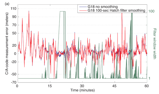
In late March, I conducted a webinar titled “A Closer Look at L5: The Future of High-Precision GNSS,” in which I discussed the impact that the new GPS L5 signal/frequency may have on high-precision users. Then, in April I was part of a discussion panel-format webinar titled “LightSquared: Our Story So Far.” Many questions and comments arose from both webinars, and I’ll attempt to address those in this column.
First of all, the day after the March 17 webinar, I published a summary with some links and illustrations. If you want to review it to refresh your memory or get a quick overview if you didn’t attend the webinar, click here.
During the March 17 webinar, I conducted several polls. Following are the poll questions with accompanying pie charts to illustrate the results. I think polls are a great tool to gain a better understanding of what your colleagues are thinking.
Poll #1: Does your organization use dual frequency GPS (L1/L2) receivers?
Gakstatter comment: Nothing earth-shattering, but good to know most of the audience members polled are high-precision users.
Poll #2: When do you plan on upgrading your GPS receivers to take advantage of the new L2C and L5 signals?
Gakstatter comment: I think the large number of “I don’t know” answers is due to two major variables. #1 is the economy. If the economy was healthy, I think folks would be more inclined to take the risk upgrade to the latest technology. #2 is the unclear status of GPS and Galileo (and other GNSS). If there was a launch schedule that people knew they could count on and plan for, I think users would be more inclined to upgrade sooner rather than later.
Poll #3: Do you believe that GPS and Galileo will meet their projected deployment dates of 2014/2015?
Gakstatter comment: I understand the skepticism about GPS and Galileo staying on schedule. I don’t think the GPS schedule can push out too far because the FAA requires a full constellation of GPS satellites broadcasting L5 by 2019. The Galileo program is under a lot of pressure to deliver something to the user community. A very important milestone this year is the scheduled September launch of the first two operational Galileo satellites, followed by the launch of a second pair the first quarter of next year. This is an opportunity for the Galileo program to set a new tone and sense of urgency with the user community.
Poll #4: How concerned are you that LightSquared’s initiative might interfere with your GPS operations?
Gakstatter comment: Since the March 17 webinar, there’s been much more information released and published about LightSquared’s potential effect on GPS. In April, I participated in a webinar about LightSquared’s potential effect on GPS with my portion of the webinar specifically addressing high-precision users. I will discuss this later in this article. But, suffice to say that this is a serious issue for the U.S. high-precision GPS user community. LightSquared isn’t going to walk away from this without putting up a big fight, and they have enough of an argument that I could see the FCC (Federal Communications Commission) folding or trying to negotiate a compromise. However, any compromise is likely to have a negative effect on the high-precision GPS user community. Best case scenario, there would be a hit in signal strength. Worst case, you’ll need a hardware upgrade.
As I normally do, a number of questions were raised during the webinar and I will address them here to the best of my ability. I’ll start with the L5 questions and then address some of the questions regarding LightSquared that were asked from both the March and April webinar.
On to the Questions
Question #1: What impact will L5 have on RTK networks?
Gakstatter comment: Great question. There’s only upside in having another GPS frequency to work with. Since the premise behind RTK Networks relies heavily on atmospheric modeling, L5 is going to help. It’s further separated, with respect to frequency, from L1 than L2 and the signal is much stronger than L2. L5 will go a long way in mitigating the effects of the atmosphere on high-precision GPS positioning.
They logistics of implementing L5, by the manufacturers, into RTK Networks may not be so easy. I’m not sure that L5 has been defined well enough in the RTCM specifications and even if it was, I’m not sure how fast manufacturers would implement it. Take, for example, L2C. Even though there are eight satellites broadcasting L2C, I’m not sure there are any RTK Networks taking advantage of it and transparency between different rover manufacturers. However, my gut tells me that manufacturers will be more willing to jump on the L5 bandwagon with a sense of urgency due to the potential significant increase in receiver performance.
Question #2: What could be a better frequency combination in terms of acheiving higher sensitivities: L2C/L5 or L1/L5?
Gakstatter comment: This is another great question. Technically speaking, I’m guessing that L2C/L5 would be a higher-performing combination due to the significantly-improved code structure of L2C (longer code and improved error-correcting methods), which allows the signal to be acquired and tracked better in tough GPS conditions such as under tree foliage.
Question #3:If I toggle on L2C in my current Trimble GNSS; that would give me an extra 8 SV broadcasting
Gakstatter comment: Good, creative thinking, but it doesn’t work that way. You are already using those eight satellites with L1 C/A and L2P. If you utilize L2C from those satellites, you’ll get some marginal gain in performance (assuming the reference station is broadcasting L2C info), but nothing like adding eight additional satellites.
Question #4:What accuracy can be expected from single frequency L5?
Gakstatter comment: It’s going to be better than L1 C/A due to the stronger signal strength (4 x more powerful than L2C) and much longer code structure (than even L2C). With SBAS corrections, we’re seeing about 60cm now with L1 C/A. It will probably be slightly better than that and definitely more robust positioning in marginal GPS conditions.
Question #5:What sort of base line distances can we expect to get with L5?
Gakstatter comment: Using L5 will definitely help with longer baselines, but baselines are already pretty long. Look at the distance between reference stations in RTK Networks today. Some are pushing 70-80km. Will they go longer than 100km? I’m not sure. That would be cool, lowering infrastructure costs of setting up and operating RTK Networks.
Question #6:Using RTK corrections the bandwidth requirements will increase with all these extra satellites will there be more efficient correction broadcast techniques like CMRx?
Gakstatter comment: I agree. I think there will need to be an efficient way of getting the data from reference network to rover. That either means using up more bandwidth on your mobile phone data plan (if you aren’t using UHF/VHF/Spread spectrum radios) or manufacturer’s inventing more efficient formats.
Questions Regarding LightSquared
LS Question #1: LightSquared is going to filter their signal heavily until it will not interfere. They have too much invested to fail.
Gakstatter comment: I agree that LightSquared is not going to walk away from their huge investment. But even if they heavily filter the base transmitters (40,000 of them), I still think there will be some interference. The nature of high-precision GNSS receivers is that they have a wideband RF front-end to take into account better code tracking and accomodate other signals such as OmniSTAR and Starfire.
Also, since LightSquared can’t control the design/production of the mobile phones that will use their system, each of the mobile phones can potentially be a “mobile GPS jammer”. It’s one thing to know the fixed location of each of the 40,000 transmitters, but how about the tens of thousand, hundreds of thousands or millions of mobile phones using the LightSquared infrastructure.
LS Question #2: What do you see as the future for OmniSTAR?
Gakstatter comment:Obviously, OmniSTAR and Starfire people must have major concerns since they are well within the LightSquared frequency spectrum. Ironically, OmniSTAR currently leases satellite bandwidth from LightSquared to broadcast their corrections.
I’m sure they are working on a solution, but I’m not privy to what the options they are considering.
Another option is another delivery method such as NTRIP over mobile phone networks.
LS Question #3: If the signal effects high precision users, it will also effect casual users(hunters, fishermen, and also field technicians – forestry inventory and utility asset mapping – will w ALL need to change the GPS devises currently used today?
Gakstatter comment: It won’t affect casual users as much as high-precision users due to the inherent design of the receivers. But, you’re right about forest inventory, utility mapping, etc. which typically use high-precision receivers. If LightSquared is allowed to continue on their desired path, it’s possible that each high-precision receiver would need to be upgraded (or traded in). That’s the worst-case scenario.
LS Question #4: Would better filters on the GPS receiver front-ends improve the concerns?
Gakstatter comment: Yes, but it’s not clear if high-precision receivers would perform as well with such filters designed into the receiver.
LS Question #5: Is the transmitter the cell phone or Lightsquare base station?
Gakstatter comment: This is a bit outside of my area, but both are transmitters. The LightSquared base stations are designed to broadcast at 1,500 watts while the mobile phone’s highest transmission power is probably 1-3 watts while it’s first connecting to the network. The base stations are transmitting at the band adjacent to GPS on the lower end while the mobile phones transmit in the adjacent band above the GPS. I look forward to reviewing the data in the next working group report to the FCC which includes interference testing from both base station transmitters as well as mobile phones.
LS Quest
ion #6: How does LightSquared affect L2C, if at all?
Gakstatter comment: From what I know and have read, I don’t think it would have any direct affect on L2 since L2 is at 1227MHz, far from LightSquared’s frequency spectrum of 1525MHz to 1559MHz. Indirectly, it would have an affect on L2P as L1/L2 receivers need L1 to utilize L2P. That’s not the case with L2C, but remember there are only eight satellites broadcasting L2C at this time.
Obviously, there is more to discuss. I didn’t touch on the affect on GLONASS receivers (yes, there is a potential problem too). The feedback I received from the LightSquared webinar is that many of you would like to have a webinar that is focused on LightSquared as it relates to the high-precision user (surveying, mapping, engineering, GIS, etc.). I plan to conduct such a webinar in early June. Stayed tuned for the announcement. Hopefully, I’ll have some interesting new data to present from the report due to the FCC on May 15.
Lastly, I attended NOAA’s Space Weather Workshop last week in Boulder, Colorado. I plan on a more comprehensive write-up, but in the mean-time you can check out my Geospatial Solutions Weekly newsletter with some info on my visit there. I’m still working on a GPS space weather notification system I wrote about last summer. I’m getting closer to having something for you.
In the past 20+ years, I’ve seen a lot of really fantastic GIS technology in many parts of the world. However, during my trip to the Denver, Colorado, area last week, I saw something that was truly mesmerizing. My concern is that I won’t be able to adequately describe it for you.
Before the cool stuff, I want to briefly tell you my visit last week of the National Oceanic and Atmospheric Administration’s (NOAA) Space Weather Prediction Center (SWPC) in Boulder. SWPC is the world’s leading facility for forecasting and issuing space weather alerts. If you think that your local weather reporter on television has a hard time delivering accuracte forecasts, folks at the SWPC say that forecasting space weather is about 50 years behind the local weatherperson forecasting temperature and preciptation on earth.
Behind the glass window is a room about the size of an average meeting room. Space weather forecasting is on the left. It is staffed during daytime hours and issues a forecast once per day (soon to be increased to three times per day). The right side of the room are the space weather monitoring people. It is staffed all the time (24/7). They are the ones that issue alerts/warnings of sun activity events within minutes of when they occur.
Why is it important to be aware of space weather?
Significant space weather events (solar storms) can have a significant impact on our infrastructure (power, telecommunications, navigation, etc.). In 1989, there was a geomagnetic storm that caused six million people in eastern Canada to lose power for nine hours. The world’s electrical power infrastructure is relatively fragile with respect to solar events. A big question that no one has the answer to is what would happen when an extreme event like the Carrington storm of 1859 occurs again. The Carrington storm was the largest geomagnetic storm in recorded history.
Of course, in 1859 there wasn’t much electonic technology around to be affected outside of telegraph systems, which were disabled in many parts of the world.
Is the Smart Grid smart enough to handle the sun?
With the introduction of the digital electronic age (computers, internet, cell phones, satellites, television, widely available electricity), we rely heavily on technology, which relies completely on electricity. It’s really hard to imagine the potential impact that an event like the 1859 Carrington storm would have in today’s world.
Last week at the Space Weather Workshop in Boulder, Colorado, Jim Caverly from the U.S. Department of Homeland Security suggested that society and public/commercial enterprises are woefully unaware of the impact of a significant geomagnetic event. As a exericse, he suggested (tongue-in-cheek) “what would happen if we turned off GPS for two days?”
GIS on a Sphere
With last week’s attention being focused on space weather, the last thing I expected to experience was the most fascinating GIS visulization tool I’ve seen in recent memory. Part of our the tour of the Space Weather Prediction Center included, to my surprise, including a demonstration of NOAA’s Science on a Sphere, which I’ve promptly renamed GIS on a Sphere.
Science on a Sphere is a 6 foot diameter ball, suspended approximately 7 feet off of the ground, on which color geographic data can be projected from four ceiling-mounted projectors spaced evenly around the “globe”.
The exhibit I saw was very much like the image in the upper right corner of the graphic above. The fantastic part about it is that the operator can display an unlimited number of datasets on the globe. In fact, the globe doesn’t even have to be the Earth. It could be the Earth’s moon, Saturn, Mars or even our Sun.
The operator for our tour, NOAA Meterologist Sara Summers, projected a number of maps on the globe, one being a map showing the tsunami’s, created by the March 11, 2011 earthquake off of the coast of Japan, as they move across the Pacific Ocean and bounce off of other continents. Another fascinating map was one of Facebook users across the globe, with a large blank area exactly the shape of China. One more map dataset illustrated commercial air traffic over the globe showing the tracers of each airliner. The visual presentation is absolutely mesmerizing and miles above any 2D display of geographic data I’ve ever seen.
My attempts to record a video of the Sara’s presentation failed miserably. Fortunately, there are several good videos on Youtube to select from.
The first Youtube video (34 seconds) is a promotional one from the Oregon Museum of Science and Industry (OMSI) which have installed a system. In fact, over 60 of the systems have been installed around the world by NOAA.
The next video is a timelapse video of a Science on a Sphere system being setup at an exhibit for the California Department of Water Resources. I wanted to give you an idea of what the complete system consists of (1m 04s).
For those of you who are interested in the engineering behind the Science on a Sphere, following is an interesting short video (1m 40s) describing the technology.
Lastly, I would be remiss in not including a video of NOAA scientist and Science on a Sphere inventor Dr. Sandy MacDonald. According to Sara, Dr. MacDonald developed Science on a Sphere in his garage in the mid-1990’s. The NOAA website reports that a patent was awarded to NOAA in August 2005, crediting Dr. MacDonald as the inventor. There are over 60 Science on a Sphere systems installed around the world (visit one near you). If you’d like one for yourself, NOAA will provide all the hardware, software, installation, training, support and documentation for around US$150,000 if you’re located within the U.S. and US$200,000 if located outside of the U.S. I commented to Sara that if I happen to win the lottery, I’ll be purchasing one. She responded “me too”.
The following video hosted by Dr. MacDonald is ~14 minutes.
Interference, detection, and mitigation — these have become topics of paramount importance to the GNSS community recently, surpassing at times even those old familiar standards accuracy, availability, and integrity.
In March, a large expert audience attended a GNSS Interference, Detection, and Mitigation (IDM) conference at the United Kingdom’s National Physical Laboratory near London. My conclusions first, followed by reportage of the details. In brief, GNSS has revolutionized positioning, navigation, and timing (PNT), but clearly, GNSS vulnerability is real, the risk is ever increasing, and we need urgently to improve interference, detection, and mitigation.
Many GNSS-related benefits that we enjoy today come from integrated systems, automation, and new, high-performance concepts of operation with fewer and less-skilled people. Reversion to older concepts of operation is not an option in many cases, and so we must build resilience into our systems.
Resilience costs money. It can be accomplished piecemeal, where each sector does its own thing, but ubiquitous solutions — standards and backup systems, among others — that draw on economies of scale will be more cost-effective.
I suspect that productive response will be hindered by a combination of ignorance, disbelief, over-confidence, technical complexity, and economic sensitivity. To wit:
ignorance of the role of GNSS in embedded systems;
disbelief that policy makers could have put all the eggs in one basket and burnt the other basket;
overconfidence because in-car navigators work so well;
the difficulty of explaining complex, technology causal loops and their impact at a business level;
the lack of desire to spend money at this point of the economic cycle.
I hope I am proved wrong.
Just prior to the conference, the UK’s Royal Academy of Engineering released its report warning of over-reliance on global navigation satellite systems. The balanced report makes key recommendations on raising awareness and analying impact, policy responses, and increasing resilience.
Further presentations during the day addressed high-level policy issues in the UK and U.S., interference detection using terrestrial and space techniques, and mitigation based on improving receiver and antenna design, integration and eLoran. All this was underpinned by a number of themes based on the ever-increasing risks (reliance and threat) and the emerging detection and mitigation response.
James Caverley (U.S. Department of Homeland Security, DHS) and Martyn Thomas (UK Royal Academy of Engineering) both addressed reliance. Caverley stressed the level of ignorance outside the GNSS community, particularly with embedded systems. He discussed a DHS timing study that found GPS timing was essential for 11 of 18 critical infrastructure and key resource sectors — although their leaders originally said GPS wasn’t needed!
Thomas stated the UK and other developed countries are dangerously dependent on GPS as a source of PNT, and that nobody has a full picture of the dependencies or vulnerabilities. But the real cause for concern is that up to 7 percent of Europe’s gross domestic product is dependent on GNSS, and many of the backups are inadequate and not exercised.
The increasing interference threat is based on capability and intent. Caverley noted the commercialization of GPS jammers, and that Canada has intercepted large numbers of jammers intended for the criminal market. The intent is varied: career criminals covering their tracks, lovesick swains wanting privacy, and the general public objecting to poor policy implementation (for example, road user charging) using GPS. Mentioning Lightsquared, Caverley stated that the DHS had been surprised by the FCC decision and that it was working hard to ensure that interference is not a problem.
IDM is at the early stage of its product life-cycle, and so a number of different detection techniques are being considered. The main challenge is that it is very hard to detect mobile interferers. The UK Technology Strategy Board has funded several projects: Charles Curry (Chronos Technology) discussed the GAARDIAN and SENTINEL projects developing IDM probe networks. Stuart Eves (Surrey Satellite Technology) discussed space-based techniques. Washington Ochieng (Imperial College) gave a fascinating presentation on the use of integrity monitoring for detecting interference. Nigel Davies (Qinetiq) described a jamming and interference mitigation system funded by the EC.
Mitigation is an even wider topic. Stephen Harding (Ofcom) outlined the UK’s regulatory options and discussions with the police of enhancing current laws. He revealed that Europe has been in discussions with LightSquared for two years. Peter Soar (Qinetiq) outlined how technical design and integration with inertial systems can mitigate jamming to some extent, but noted that best-practice is not discussed because companies want to protect their intellectual property.
Thomas expressed strong support for eLoran as a backup, and George Shaw (General Lighthouse Authorities) described a business case where eLoran had the largest, positive economic return over the cost-benefit period; all other approaches were negative. Caverley stated that a nationally accessible backup for timing is important, but he is not sure whether the U.S. needs a ubiquitous system.
Sally Basker, former director of research and radionavigation at the General Lighthouse Authorities of the UK and IReland, has opened Sally Basker Consulting: strategy, business, and technology advice with expertise in navigation services. See www.baskerconsulting.com.
To illustrate the fix we’re in, Logan Scott offered this analogy for out-of-band interference during the April webinar, “LightSquared and GPS: Our Story So Far.” We’re driving at night and come upon a bicylist with one of those little flashing lights. That’s the GPS signal. So far, so safe. We know the bicyclist’s position.
Then around the bend comes a truck with its headlights on high-beam, in the adjacent lane, but brights set at our eye level. That’s the LightSquared signal.
Where’s the bicyclist? Uh oh.
That is not the only light off which we are fending. Some of it we generated ourselves — with help from neighbors and children and friends and employers and, well, just about anyone with a mobile online connection.
Every time you:
download a map and driving directions to your cell phone or wireless-connected PND;
stream a movie to your cell phone (all right, so only youngersomethings of your acquaintance actually do this. They still have the eyesight for it);
while on the road, tap wirelessly into your company’s complex database of whatever kind that has been moved to “the cloud” in a cost-saving and efficiency-ramping measure;
download a Zen meditatation app to your mobile, one with scientifically designed binaural rhythms using embedded beats to induce a trance-like state through brainwave entrainment for ultimate relaxation, stress reduction, pain management, improved sleep quality, super learning, enhanced creativity, out-of-body experience, and lucid dreaming (I kid you not); or
get sports updates and video highlights direct to your phone —
Every time you do any one of these or myriad other activities on your handy pocket communications device, you, sir or madam, are contibuting to the problem that the GNSS community now struggles with.
Society has developed a ravenous appetite for huge volumes of virtual data, and we are not at all content to wait until getting home or to the office for a wired connection to access it. We want it now! On the road or sidewalk, in the coffeeshop, in the mall, in the stadium, along the running path, yea, even unto in the wilderness.
This appetite will only grow. LightSquared — mark my words, it will have plenty of company following — wants wider bandwidth to help you access online data faster. Sooner than you can say “traffic congestion,” even more data will be on offer, with even greater demand for wider bandwidth.
As one webinar attendee e-mailed (he wrote in all caps to emphasize his feelings, but they are downsized here),
“Do y’all think this has anything to do with the fact that mobile phone companies can make significantly more money streaming TV to cell phones than with GPS applications?”
Improving Single-Frequency RTK in the Urban Enviornment
By Mojtaba Bahrami and Marek Ziebart
A look at how Doppler measurements can be used to smooth noisy code-based pseudoranges to improve the precision of autonomous positioning as well as to improve the availability of single-frequency real-time kinematic positioning, especially in urban environments.
INNOVATION INSIGHTS by Richard Langley
WHAT DO A GPS RECEIVER, a policeman’s speed gun, a weather radar, and some medical diagnostic equipment have in common? Give up? They all make use of the Doppler effect. First proposed in 1842 by the Austrian mathematician and physicist, Christian Doppler, it is the change in the perceived frequency of a wave when the transmitter and the receiver are in relative motion.
Doppler introduced the concept in an attempt to explain the shift in the color of light from certain binary stars. Three years later, the effect was tested for sound waves by the Dutch scientist Christophorus Buys Ballot. We have all heard the Doppler shift of a train whistle or a siren with their descending tones as the train or emergency vehicle passes us. Doctors use Doppler sonography — also known as Doppler ultrasound — to provide information about the flow of blood and the movement of inner areas of the body with the moving reflectors changing the received ultrasound frequencies. Similarly, some speed guns use the Doppler effect to measure the speed of vehicles or baseballs and Doppler weather radar measures the relative velocity of particles in the air.
The beginning of the space age heralded a new application of the Doppler effect. By measuring the shift in the received frequency of the radio beacon signals transmitted by Sputnik I from a known location, scientists were able to determine the orbit of the satellite. And shortly thereafter, they determined that if the orbit of a satellite was known, then the position of a receiver could be determined from the shift. That realization led to the development of the United States Navy Navigation Satellite System, commonly known as Transit, with the first satellite being launched in 1961. Initially classified, the system was made available to civilians in 1967 and was widely used for navigation and precise positioning until it was shut down in 1996. The Soviet Union developed a similar system called Tsikada and a special military version called Parus. These systems are also assumed to be no longer in use — at least for navigation.
GPS and other global navigation satellite systems use the Doppler shift of the received carrier frequencies to determine the velocity of a moving receiver. Doppler-derived velocity is far more accurate than that obtained by simply differencing two position estimates. But GPS Doppler measurements can be used in other ways, too. In this month’s column, we look at how Doppler measurements can be used to smooth noisy code-based pseudoranges to improve the precision of autonomous positioning as well as to improve the availability of single-frequency real-time kinematic positioning, especially in urban environments.
Correction and Further Details
The first experimental Transit satellite was launched in 1959. A brief summary of subsequent launches follows:
Transit 1A launched 17 September 1959 failed to reach orbit
Transit 1B launched 13 April 1960 successfully
Transit 2A launched 22 June 1960 successfully
Transit 3A launched 30 November 1960 failed to reach orbit
Transit 3B launched 22 February 1961 failed to deploy in correct orbit
Transit 4A launched 29 June 1961 successfully
Transit 4B launched 15 November 1961 successfully
Transits 4A and 4B used the 150/400 MHz pair of frequencies and provided geodetically useful results.
A series of Transit prototype and research satellites was launched between 1962 and 1964 with the first fully operational satellite, Transit 5-BN-2, launched on 5 December 1963.
The first operational or Oscar-class Transit satellite, NNS O-1, was launched on 6 October 1964.
The last pair of Transit satellites, NNS O-25 and O-31, was launched on 25 August 1988.
“Innovation” is a regular column that features discussions about recent advances in GPS technology and its applications as well as the fundamentals of GPS positioning. The column is coordinated by Richard Langley of the Department of Geodesy and Geomatics Engineering at the University of New Brunswick, who welcomes your comments and topic ideas. To contact him, email lang @ unb.ca.
Real-time kinematic (RTK) techniques enable centimeter-level, relative positioning. The technology requires expensive, dedicated, dual-frequency, geodetic-quality receivers. However, myriad industrial and engineering applications would benefit from small-size, cost-effective, single-frequency, low-power, and high-accuracy RTK satellite positioning. Can such a sensor be developed and will it deliver? If feasible, such an instrument would find many applications within urban environments — but here the barriers to success are higher. In this article, we show how some of the problems can be overcome.
Single-Frequency RTK
Low-cost single-frequency (L1) GPS receivers have attained mass-market status in the consumer industry. Notwithstanding current levels of maturity in GPS hardware and algorithms, these receivers still suffer from large positioning errors. Any positioning accuracy improvement for mass-market receivers is of great practical importance, especially for many applications demanding small size, cost-effectiveness, low power consumption, and highly accurate GPS positioning and navigation. Examples include mobile mapping technology; machine control; agriculture fertilization and yield monitoring; forestry; utility services; intelligent transportation systems; civil engineering projects; unmanned aerial vehicles; automated continuous monitoring of landslides, avalanches, ground subsidence, and river level; and monitoring deformation of built structures. Moreover, today an ever-increasing number of smartphones and handsets come equipped with a GPS receiver. In those devices, the increasing sophistication of end-user applications and refinement of map databases are continually tightening the accuracy requirements for GPS positioning.
For single-frequency users, the RTK method does appear to offer the promise of highly precise position estimates for stationary and moving receivers and can even be considered a candidate for integration within mobile handhelds. Moreover, the RTK approach is attractive because the potential of the existing national infrastructures such as Great Britain’s Ordnance Survey National GNSS Network-RTK (OSNet) infrastructure, as well as enabling technologies such as the Internet and the cellular networks, can be exploited to deliver RTK corrections and provide high-precision positioning and navigation.
The basic premise of relative (differential) positioning techniques such as RTK is that many of the sources of GNSS measurement errors including the frequency-dependent error (the ionospheric delay) are spatially correlated. By performing relative positioning between receivers, the correlated measurement errors are completely cancelled or greatly reduced, resulting in a significant increase in the positioning accuracy and precision.
Single-Frequency Challenges. Although RTK positioning is a well-established and routine technology, its effective implementation for low-cost, single-frequency L1 receivers poses many serious challenges, especially in difficult and degraded signal environments for GNSS such as urban canyons. The most serious challenge is the use of only the L1 frequency for carrier-phase integer ambiguity resolution and validation. Unfortunately, users with single-frequency capability do not have frequency diversity and many options in forming useful functions and combinations for pseudorange and carrier-phase observables. Moreover, observations from a single-frequency, low-cost receiver are typically “biased” due to the high level of multipath and/or receiver signal-tracking anomalies and also the low-cost patch antenna design that is typically used. In addition, in those receivers, measurements are typically contaminated with high levels of noise due to the low-cost hardware design compared to the high-end receivers. This makes the reliable fixing of the phase ambiguities to their correct integer values, for single-frequency users, a non-trivial problem. As a consequence, the reliability of single-frequency observations to resolve ambiguities on the fly in an operational environ
ment is relatively low compared to the use of dual-frequency observations from geodetic-quality receivers. Improving performance will be difficult, unless high-level noise and multipath can be dealt with effectively or unless ambiguity resolution techniques can be devised that are more robust and are less sensitive to the presence of biases and/or high levels of noise in the observations.
Traditionally, single-frequency RTK positioning requires long uninterrupted initialization times to obtain reliable results, and hence have a time-to-fix ambiguities constraint. Times of 10 to 25 minutes are common. Observations made at tens of continuous epochs are used to determine reliable estimates of the integer phase ambiguities. In addition, these continuous epochs must be free from cycle slips, loss of lock, and interruptions to the carrier-phase signals for enough satellites in view during the ambiguity fixing procedure. Otherwise, the ambiguity resolution will fail to fix the phase ambiguities to correct integer values. To overcome these drawbacks and be able to determine the integer phase ambiguities and thus the precise relative positions, observations made at only one epoch (single-epoch) can be used in resolving the integer phase ambiguities. This allows instantaneous RTK positioning and navigation for single-frequency users such that the problem of cycle slips, discontinuities, and loss of lock is eliminated. However, for single-frequency users, the fixing of the phase ambiguities to their correct integer values using a single epoch of observations is a non-trivial problem; indeed, it is considered the most challenging scenario for ambiguity resolution at the present time.
Instantaneous RTK positioning relies fundamentally upon the inversion of both carrier-phase measurements and code measurements (pseudoranges) and successful instantaneous ambiguity resolution. However, in this approach, the probability of fixing ambiguities to correct integer values is dominated by the relatively imprecise pseudorange measurements. This is more severe in urban areas and difficult environments where the level of noise and multipath on pseudoranges is high. This problem may be overcome partially by carrier smoothing of pseudoranges in the range/measurement domain using, for example, the Hatch filter. While carrier-phase tracking is continuous and free from cycle slips, the carrier smoothing of pseudoranges with an optimal smoothing filter window-width can effectively suppress receiver noise and short-term multipath noise on pseudoranges. However, the effectiveness of the conventional range-domain carrier-smoothing filters is limited in urban areas and difficult GNSS environments because carrier-phase measurements deteriorate easily and substantially due to blockages and foliage and suffer from phase discontinuities, cycle-slip contamination, and other measurement anomalies. This is illustrated in Figure 1. The figure shows that in a kinematic urban environment, frequent carrier-phase outages and anomalies occur, which cause frequent resets of the carrier-smoothing filter and hence carrier smoothing of pseudoranges suffers in robustness and effective continuous smoothing.
Figure 1. Satellite tracking and carrier-phase anomaly summary during the observation time-span. These data were collected in a dense urban environment in both static and kinematic mode. The superimposed red-points show epochs where carrier-phase observables are either missing or contaminated with cycle slips, loss of locks, and/or other measurement anomalies.
Doppler Frequency Shift. While carrier-phase tracking can be discontinuous in the presence of continuous pseudoranges, a receiver generates continuous Doppler-frequency-shift measurements. The Doppler measurements are immune to cycle slips. Moreover, the precision of the Doppler measurements is better than the precision of pseudoranges because the absolute multipath error of the Doppler observable is only a few centimeters. Thus, devising methods that utilize the precision of raw Doppler measurements to reduce the receiver noise and high-frequency multipath on pseudoranges may prove valuable especially in GNSS-challenged environments. Figure 2 shows an example of the availability and the precision of the receiver-generated Doppler measurements alongside the delta-range values derived from the C/A-code pseudoranges and from the L1 carrier-phase measurements. This figure also shows that frequent carrier-phase outages and anomalies occur while for every C/A-code pseudorange measurement there is a corresponding Doppler measurement available.
Figure 2. Plots of C/A-code-pseudorange-derived delta-ranges (top), L1 carrier-phase-derived delta-ranges (middle), and L1 raw receiver-generated Doppler shifts that are transformed into delta-ranges for the satellite PRN G18 during the observation time-span when it was tracked by the receiver (bottom).
Smoothing. A rich body of literature has been published exploring aspects of carrier smoothing of pseudoranges. One factor that has not received sufficient study in the literature is utilization of Doppler measurements to smooth pseudoranges and to investigate the influence of improved pseudorange accuracy on both positioning and the integer-ambiguity resolution. Utilizing the Doppler measurements to smooth pseudoranges could be a good example of an algorithm that maximally utilizes the information redundancy and diversity provided by a GPS/GNSS receiver to improve positioning accuracy. Moreover, utilizing the Doppler measurements does not require any hardware modifications to the receiver. In fact, receivers measure Doppler frequency shifts all the time as a by-product of satellite tracking.
GNSS Doppler Measurement Overview
The Doppler effect is the apparent change in the transmission frequency of the received signal and is experienced whenever there is any relative motion between the emitter and receiver of wave signals. Theoretically, the observed Doppler frequency shift, under Einstein’s Special Theory of Relativity, is approximately equal to the difference between the received and transmitted signal frequencies, which is approximately proportional to the receiver-satellite topocentric range rate.
Beat Frequency. However, the transmitted frequency is replicated locally in a GNSS receiver. Therefore, strictly speaking, the difference of the received frequency and the receiver locally generated replica of the transmitted frequency is the Doppler frequency shift that is also termed the beat frequency. If the receiver oscillator frequency is the same as the satellite oscillator frequency, the beat frequency represents the Doppler frequency shift due to the relative, line-of-sight motion between the satellite and the receiver. However, the receiver internal oscillator is far from being perfect and therefore, the receiver Doppler measurement output is the apparent Doppler frequency shift (that includes local oscillator effects). The Doppler frequency shift is also subject to satellite-oscillator frequency bias and other disturbing effects such as atmospheric effects on the signal propagation.
To estimate the range rate, a receiver typically forms an average of the delta-range by simply integrating the Doppler over a very short period of time (for example, 0.1 second) and then dividing it by the duration of the integration interval. Since the integration of frequency over time gives the phase of the signal over that time interval, the procedure continuously forms the carrier-phase observable that is the integrated Doppler over time. Therefore, Doppler frequency shift can also be estimated by time differencing carrier-phase measurements. The carrier-phase-derived Doppler is com
puted over a longer time span, leading to smoother Doppler measurements, whereas direct loop filter output is an instantaneous measure produced over a short time interval.
Doppler frequency shift is routinely used to determine the satellite or user velocity vector. Apart from velocity determination, it is worth mentioning that Doppler frequency shifts are also exploited for coarse GPS positioning. Moreover, the user velocity vector obtained from the raw Doppler frequency shift can be and has been applied by a number of researchers to instantaneous RTK applications to constrain the float solution and hence improve the integer-ambiguity-resolution success rates in kinematic surveying. In this article, a simple combination procedure of the noisy pseudorange measurements and the receiver-generated Doppler measurements is suggested and its benefits are examined.
Doppler-Smoothing Algorithm Description
Motivated both by the continual availability and the centimeter-level precision of receiver-generated (raw) Doppler measurements, even in urban canyons, a method has been introduced by the authors that utilizes the precision of raw Doppler measurements to reduce the receiver noise and high-frequency multipath on code pseudoranges. For more detail on the Doppler-smoothing technique, see Further Reading. The objective is to smooth the pseudoranges and push the accuracy of the code-based or both code- and carrier-based positioning applications in GNSS-challenged environments.
Previous work on Doppler-aided velocity/position algorithms is mainly in the position domain. In those approaches, the improvement in the quality of positioning is gained mainly by integrating the kinematic velocities and accelerations derived from the Doppler measurement in a loosely coupled extended Kalman filter or its variations such as the complementary Kalman filter. Essentially, these techniques utilize the well-known ability of the Kalman filter to use independent velocity estimates to reduce the noise of positioning solutions and improve positioning accuracy. The main difference among these position-domain filters is that different receiver dynamic models are used.
The proposed method combines centimeter-level precision receiver-generated Doppler measurements with pseudorange measurements in a combined pseudorange measurement that retains the significant information content of each.
Two-Stage Process. The proposed Doppler-smoothing process has two stages: (1) the prediction or initialization stage and (2) the filtering stage. In the prediction stage, a new estimated smoothed value of the pseudorange measurement for the Doppler-smoothing starting epoch is obtained. In this stage, for a fixed number of epochs, a set of estimated pseudoranges for the starting epoch is obtained from the subsequent pseudorange and Doppler measurements. The estimated pseudoranges are then averaged to obtain a good estimated starting point for the smoothing process. The number of epochs used in the prediction stage is the averaging window-width or Doppler-smoothing-filter length. In the filtering stage, the smoothed pseudorange profile is constructed using the estimated smoothed starting pseudorange and the integrated Doppler measurements over time. The Doppler-smoothing procedures outlined here can be performed successively epoch-by-epoch (that is, in a moving filter), where the estimated initial pseudorange (the averaged pseudorange) is updated from epoch to epoch. Alternatively, an efficient and elegant implementation of the measurement-domain Doppler-smoothing method is in terms of a Kalman filter, where it can run as a continuous process in the receiver from the first epoch (or in post-processing software, but then without the real-time advantage). This filter allows real-time operation of the Doppler-smoothing approach.
In the experiments described in this article, a short filter window-width is used. The larger the window width used in the averaging filter process, the more precise the averaged pseudorange becomes. However, this filter is also susceptible to the ionospheric divergence phenomenon because of the opposite signs of the ionospheric contribution in the pseudorange and Doppler observables. Therefore, the ionospheric divergence effect between pseudoranges and Doppler observables increases with averaging window-width and the introduced bias in the averaged pseudoranges become apparent for longer filter lengths.
Using the propagation of variance law, it can be shown that the precision of the delta-range calculated with the integrated Doppler measurements over time depends on both the Doppler-measurement epoch interval and the precision of the Doppler measurements, assuming that noise/errors on the measurements are uncorrelated.
Experimental Results
To validate the improvement in the performance and availability of single-frequency instantaneous RTK in urban areas, the proposed Doppler-aided instantaneous RTK technique has been investigated using actual GPS data collected in both static and kinematic pedestrian trials in central London. In this article, we only focus on the static results and the kinematic trial results are omitted. It is remarked, however, that the data collected in the static mode were post-processed in an epoch-by-epoch approach to simulate RTK processing.
In the static testing, GPS test data were collected with a measurement rate of 1 Hz. At the rover station, a consumer-grade receiver with a patch antenna was used. This is a single-frequency 16-channel receiver that, in addition to the C/A-code pseudoranges, is capable of logging carrier-phase measurements and raw Doppler measurements. Reference station data were obtained from the Ordnance Survey continuously operating GNSS network. Three nearby reference stations were selected that give different baseline lengths: Amersham (AMER) ≈ 38.3 kilometers away, Teddington (TEDD) ≈ 20.8 kilometers away, and Stratford (STRA) ≈ 7.1 kilometers away. In addition, a virtual reference station (VRS) was also generated in the vicinity (60 meters away) of the rover receiver.
Doppler-Smoothing. Before we present the improvement in the performance of instantaneous RTK positioning, the effect of the Doppler-smoothing of the pseudoranges in the measurement domain and comparison with carrier-phase smoothing of pseudoranges is given. To do this, we computed the C/A-code measurement errors or observed range deviations (the differences between the expected and measured pseudoranges) in the static mode (with surveyed known coordinates) using raw, Doppler-smoothed and carrier-smoothed pseudoranges. FIGURE 3a illustrates the effect of 100-second Hatch-filter carrier smoothing and FIGURE 3b shows a 100-second Doppler-smoothing of the pseudoranges for satellite PRN G28 (RINEX satellite designator) with medium-to-high elevation angle. The raw observed pseudorange deviations (in blue) are also given as reference. The quasi-sinusoidal oscillations are characteristic of multipath. Comparing the Doppler-smoothing in Figure 3b to the Hatch carrier-smoothing in Figure 3a, it can be seen that Doppler-smoothing of pseudoranges offers a modest improvement and is more robust and effective than that of the traditional Hatch filter in difficult environments.
Figure 3. Smoothed pseudorange errors (observed range deviations) using the traditional Hatch carrier-smoothing filter. Smoothing filter length in the experiments for both filters was set to 100 seconds. Satellite PRN G28 was chosen to represent a satellite at medium-to-high elevation angle.Figure 3. Smoothed pseudorange errors (observed range deviations) using the Doppler-smoothing filter. Smoothing filter length in the experiments for both filters was set to 100 seconds. Satellite PRN G28 was chosen to represent a satellite at medium-to-high elevation angle.
Figure 4a illustrates carrier-phase Hatch-filter smoothing for low-elevation angle satellite PRN G18. In this figure, the Hatch carrier-smoothing filter reset is indicated. It can be seen that due to the frequent carrier-phase discontinuities and cycle slips, the smoothing has to be reset and restarted from the beginning and hardly reaches its full potential. In contrast, Doppler smoothing for PRN G18 shown in FIGURE 4b had few filter resets and managed effectively to smooth the very noisy pseudorange in some sections of the data.
Figure 4. Smoothed pseudorange errors (observed range deviations) and filter resets and filter length (window width) using the traditional Hatch carrier-smoothing filter. Smoothing filter length in the experiments for both filters was set to 100 seconds. Satellite PRN G18 was chosen to represent a satellite at low elevation angle as it rises from 10 to 30 degrees.Figure 4. Smoothed pseudorange errors (observed range deviations) and filter resets and filter length (window width) using the Doppler-smoothing. Smoothing filter length in the experiments for both filters was set to 100 seconds. Satellite PRN G18 was chosen to represent a satellite at low elevation angle as it rises from 10 to 30 degrees.
Considering RTK in this analysis, we can demonstrate the increase in the success rate of the Doppler-aided integer ambiguity resolution (and hence the RTK availability) by comparison of the obtained integer ambiguity vectors from the conventional LAMBDA (Least-squares AMBiguity Decorrelation Adjustment) ambiguity resolution method using Doppler-smoothed pseudoranges with those obtained without Doppler-aiding in post-processed mode. The performance of ambiguity resolution was evaluated based on the number of epochs where the ambiguity validation passed the discrimination/ratio test. The ambiguity validation ratio test was set to the fixed critical threshold of 2.5 in all the experiments. In addition to the ratio test, the fixed solutions obtained using the fixed integer ambiguity vectors that passed the ratio test were compared against the true position of the surveyed point to make sure that indeed the correct set of integer ambiguities were estimated.
The overall performance of the single-epoch single-frequency integer ambiguity resolution obtained by the conventional LAMBDA ambiguity resolution method without Doppler-aiding is shown in Figure 5 for baselines from 60 meters up to 38 kilometers in length. In comparison, the performance of the single-epoch single-frequency integer ambiguity resolution from the LAMBDA method using Doppler-smoothed pseudoranges are shown in Figure 6 for those baselines and they are compared with integer ambiguity resolution success rates of the conventional LAMBDA ambiguity resolution method without Doppler-aiding. Figure 6 shows that using Doppler-smoothed pseudoranges enhances the probability of identifying the correct set of integer ambiguities and hence increases the success rate of the integer ambiguity resolution process in instantaneous RTK, providing higher availability. This is more evident for shorter baselines. For long baselines, the residual of satellite-ephemeris error and atmospheric-delay residuals that do not cancel in double differencing potentially limits the effectiveness of the Doppler-smoothing approach. It is well understood that those residuals for long baselines strongly degrade the performance of ambiguity resolution. Relative kinematic positioning with single frequency mass-market receivers in urban areas using VRS has also shown improvement.
Figure 5. Single-epoch single-frequency integer ambiguity resolution success rate obtained by the conventional LAMBDA ambiguity resolution method without Doppler-aiding.Figure 6. Plots of integer ambiguity resolution success rates: single-epoch single-frequency integer ambiguity resolution success rate obtained by the conventional LAMBDA ambiguity resolution method without Doppler-aiding (in blue) and using Doppler-smoothed pseudoranges (in green).
Conclusion
In urban areas, the proposed Doppler-smoothing technique is more robust and effective than traditional carrier smoothing of pseudoranges. Static and kinematic trials confirm this technique improves the accuracy of the pseudorange-based absolute and relative positioning in urban areas characteristically by the order of 40 to 50 percent.
Doppler-smoothed pseudoranges are then used to aid the integer ambiguity resolution process to enhance the probability of identifying the correct set of integer ambiguities. This approach shows modest improvement in the ambiguity resolution success rate in instantaneous RTK where the probability of fixing ambiguities to correct integer values is dominated by the relatively imprecise pseudorange measurements.
The importance of resolving the integer ambiguities correctly must be emphasized. Therefore, devising innovative and robust methods to maximize the success rate and hence reliability and availability of single-frequency, single-epoch integer ambiguity resolution in the presence of biased and noisy observations is of great practical importance especially in GNSS-challenged environments.
Acknowledgments
The study reported in this article was funded through a United Kingdom Engineering and Physical Sciences Research Council Engineering Doctorate studentship in collaboration with the Ordnance Survey. M. Bahrami would like to thank his industrial supervisor Chris Phillips from the Ordnance Survey for his continuous encouragement and support. Professor Paul Cross is acknowledged for his valuable comments. The Ordnance Survey is acknowledged for sponsoring the project and providing detailed GIS data.
Manufacturer
The data for the trial discussed in this article were obtained from a u-blox AG AEK-4T receiver with a u-blox ANN-MS-0-005 patch antenna.
Mojtaba Bahrami is a research fellow in the Space Geodesy and Navigation Laboratory (SGNL) at University College London (UCL). He holds an engineering doctorate in space geodesy and navigation from UCL.
Marek Ziebart is a professor of space geodesy at UCL. He is the director of SGNL and vice dean for research in the Faculty of Engineering Sciences at UCL.
FURTHER READING
• Carrier Smoothing of Pseudoranges
“Optimal Hatch Filter with an Adaptive Smoothing Window Width” by B. Park, K. Sohn, and C. Kee in Journal of Navigation, Vol. 61, 2008, pp. 435–454, doi: 10.1017/S0373463308004694.
“Optimal Recursive Least-Squares Filtering of GPS Pseudorange Measurements” by A. Q. Le and P. J. G. Teunissen in VI Hotine-Marussi Symposium on Theoretical and Computational Geodesy, Wuhan, China, May 29 – June 2, 2006, Vol. 132 of the International Association of Geodesy Symposia, Springer-Verlag, Berlin and Heidelberg, 2008, Part II, pp. 166–172, doi: 10.1007/978-3-540-74584-6_26.
“The Synergism of GPS Code and Carrier Measurements” by R. Hatch in Proceedings of the 3rdInternational Geodetic Symposium on Satellite Doppler Positioning, Las Cruces, New Mexico, February 8-12, 1982, Vol. 2, pp. 1213–1231.
• Combining Pseudoranges and Carrier-phase Measurements in the Position Domain
“Position Domain Filtering and Range Domain Filtering for Carrier-smoothed-code DGNSS: An Analytical Comparison” by H. Lee, C. Rizos, and G.-I. Jee in IEE Proceedings Radar, Sonar and Navigation, Vol. 152, No. 4, August 2005, pp. 271–276, doi:10.1049/ip-rsn:20059008.
“Complementary Kalman Filter for Smoothing GPS Position with GPS Velocity” by H. Leppakoski, J. Syrjarinne, and J. Takala in Proceedings of ION GPS/GNSS 2003, the 16th International Technical Meeting of the Satellite Division of The Institute of Navigation, Portland, Oregon, September 9–
12, 2003, pp. 1201–1210.
“GPS Navigation: Combining Pseudorange with Continuous Carrier Phase Using a Kalman Filter” by P. Y. C. Hwang and R. G. Brown in Navigation, Journal of The Institute of Navigation, Vol. 37, No. 2, 1990, pp. 181–196.
• Doppler-derived Velocity Information and RTK Positioning
“Advantage of Velocity Measurements on Instantaneous RTK Positioning” by N. Kubo in GPS Solutions, Vol. 13, No. 4, 2009, pp. 271–280, doi: 10.1007/s10291-009-0120-9.
• Doppler Smoothing of Pseudoranges and RTK Positioning
Doppler-Aided Single-Frequency Real-Time Kinematic Satellite Positioning in the Urban Environment by M. Bahrami, Ph.D. dissertation, Space Geodesy and Navigation Laboratory, University College London, U.K., 2011.
“Instantaneous Doppler-Aided RTK Positioning with Single Frequency Receivers” by M. Bahrami and M. Ziebart in Proceedings of PLANS 2010, IEEE/ION Position Location and Navigation Symposium, Indian Wells, California, May 4–6, 2010, pp. 70–78, doi: 10.1109/PLANS.2010.5507202.
“Getting Back on the Sidewalk: Doppler-Aided Autonomous Positioning with Single-Frequency Mass Market Receivers in Urban Areas” by M. Bahrami in Proceedings of ION GNSS 2009, the 22nd International Technical Meeting of the Satellite Division of The Institute of Navigation, Savannah, Georgia, 22–25 September 2009, pp. 1716–1725.
• Integer Ambiguity Resolution
“GPS Ambiguity Resolution and Validation: Methodologies, Trends and Issues” by D. Kim and R. B. Langley in Proceedings of the 7th GNSS Workshop – International Symposium on GPS/GNSS, Seoul, Korea, 30 November – 2 December 2000, Tutorial/Domestic Session, pp. 213–221.
“The Least-Squares Ambiguity Decorrelation Adjustment: a Method for Fast GPS Integer Ambiguity Estimation” by P.J.G. Teunissen in Journal of Geodesy, Vol. 70, No. 1–2, 1995, pp. 65–82, doi: 10.1007/BF00863419.
Plus: GLONASS CDMA Tracked, Third Beidou-2 Launched
The second report from non‐governmental members of the LightSquared/GPS Technical Working Group (TWG) was filed with the Federal Communications Commission (FCC) on April 15. For those anxious to see actual results of interference/desensitization of GPS receivers by the proposed LightSquared terrestrial signal — or, conversely, absence of said results — the report does not contain any such hard news. It relates the set-up of TWG work sub-teams to test various categories of GPS devices and receivers.
The sub-teams have identified laboratories for testing activities, developed test plans, and identified devices, receivers, and systems to be tested. Attachments to the report include current draft test plans and the current list of devices and receiver models submitted for testing by companies.
The following sections summarize the testing laboratories and devices selected for testing by each sub-team:
aviation
cellular
general location/navigation
high precision, networks, and timing. These three sub-teams are collaborating to a large extent.
space-based receivers.
The full report also includes a “high-level description of test plan” by each sub-team.
Aviation Sub‐Team. The aviation sub‐team will rely primarily on testing, funded by the Federal Aviation Administration (FAA), that will be performed at Zeta Associates Incorporated of Fairfax, Virginia.
Additional testing is planned by the U.S. government at White Sands Missile Range and Holloman Air Force Base, both in New Mexico, for use by the National PNT Engineering Forum (NPEF) LightSquared Working Group. These results will be considered for inclusion in the TWG Final Report by the aviation sub‐team. Presumably, this group will test military receivers, under classified categorization.
The aviation receivers are representative of those in use today. Their selection was based mainly upon device availability (those already owned by the FAA Technical Center). They are: Canadian Marconi GLSSU 5024; Garmin 300XL; Garmin GNS 430W; Garmin GNS 480; Rockwell Collins GLU‐920 multimode receiver; Rockwell Collins GLU‐925 multimode receiver; Rockwell Collins GNLU‐930 multimode receiver; Symmetricomm timing card (used for an FAA automation system); WAAS NovAtel G‐II ground reference station; and Zyfer timing receiver (used for the WAAS ground network).
Cellular Sub‐Team. The cellular sub‐team is in the process of engaging PC TEST, Columbia, Maryland; CETECOM, Milpitas, California; InterTek, Lexington, Kentucky; and ETS Lindgren, Cedar Park, Texas, for device testing.
The cellular sub‐team expects to test approximately 50 different device models. The selections represent current and legacy devices and have been prioritized based on sales volumes. While it is expected that there will be some representation of data‐only devices and femtocells, the testing will focus largely on handheld devices.
Those designated for testing are: Apple iPhone 4 (GSM and CDMA); HTC A6366; HTC ADR6200; HTC ADR63002; HTC ADR63003; HTC ADR6400L; HTC Touch Pro 2; LG Lotus Elite; LG Rumor Touch; LG VN250; LG VS740; LG VX5500; LG VX5600; LG VX8300; LG VX8360; LG VX8575; LG VX9100; LG VX9200; Motorola A855; Motorola DROID X; Motorola VA76R; Motorola W755; Nokia 6650; Nokia E71x; RIM 8330C; RIM 8530; RIM 9630; RIM 9650; RIM 9800; Samsung Moment; Samsung SCH‐U310; Samsung SCH‐U350; Samsung SCH‐U450; Samsung SCH‐U640; Samsung SCH‐U750; Samsung SGHi617; Samsung SGHi917; Sierra Wireless 250 U USG 3G/4G; and Sony Ericsson W760a.
General Location/Navigation. This sub-team has chosen Alcatel/Lucent as its initial facility for testing. Twenty-six devices were selected based on nominations by manufacturers represented on the sub‐team, considering the percentage of the installed user base.
They include: Garmin Forerunner 110 and 305; Garmin ETREX‐H; Garmin Dakota 20; Garmin Oregon 550; Garmin GTU 10; BI Inc. ExacuTrack One; Garmin GPS 17X; Garmin GPSMAP 441; Hemisphere Vector MV101; GM OnStar (model TBD); Garmin GVN 54; TomTom XL335; TomTom ONE 3RD Edition; TomTom GO 2505; Garmin nűvi 2X5W, 13XX, 3XX, and 37XX; Garmin GPSMAP 496; Garmin aera 5xx; Honeywell Bendix/King AV8OR; Trimble iLM2730; Trimble TVG‐850; Trimble Placer Gold; and Hemisphere Outback S3.
High Precision-Networks-Timing. The HPN&T sub‐teams are collaborating extensively to develop joint test plans and procedures. The joint sub-teams have chosen the U.S. Navy’s NAVAIR facility for testing.
To be tested are: Hemisphere R320; Hemisphere A320; Deere iTC; Deere SF‐3000; Deere SF‐3050; Trimble MS990; Trimble MS992; Trimble AgGPS 252, AgGPS 262, AgGPS 442, and AgGPS EZguide 500; Trimble CFX 750; Trimble FMX; Trimble GeoExplorer 3000 series GeoXH and GeoXT; Trimble GeoExplorer 6000 series GeoXH and GeoXT; Trimble Juno SB; Trimble NetR9 and NetR5; Trimble R8 GNSS; Trimble 5800; Leica SR530; Leica GX1200 Classic; Leica GX1230GG; Leica GR10; Leica Uno; Leica GS15; Topcon HiPer Ga and HiPer II; Topcon GR‐3 and GR‐5; Topcon MC‐R3; Topcon NET‐G3A; Topcon TruPath/AGI‐3; NovAtel PROPAK‐G2‐Plus; NovAtel FLEXG2‐STAR; NovAtel FLEXPAK‐G2‐V1, FLEXPAK‐G2‐V2 and FLEXPAK6; NovAtel PROPAK‐V3; NovAtel DL‐V3; Septentrio PolaRx3e; and Septentrio AsteRx3.
Space‐Based Receivers. Lab testing has been conducted at the NASA Jet Propulsion Laboratory (JPL) in California. The receivers are used by NASA for space‐based missions and high-precision science applications. The TWG agreed that these would be tested at JPL by NASA, with participation by LightSquared personnel, and the results provided to the TWG; see Appendix G
The devices tested are current or representative of GPS receivers in use by NASA or planned for use in the near future for space and science applications: TriG (NASA Next‐generation Space Receiver) and IGOR (Space Receiver).
NASA/JPL also tested the following high-precision receivers and shared the results with the HPT&N sub‐team: JAVAD Delta G3T (High Precision‐IGS) and Ashtech Z12 (High Precision‐IGS).
Conclusion. For all sub-teams, analyses will consider both LightSquared’s expected transmit power of 62 dBm per channel and its maximum authorized transmit power of 72 dBm per channel.
The WG co‐chairs will update the Commission on its progress in a subsequent report on May 16.
The April 15 TWG report contains these appendices: Working Group Roster; List of Receivers and Devices; Aviation Test Procedure; Cellular Test Plan Draft; General Location/Navigation Test Plan Draft; High Precision/Networks/Timing Test Plans Draft; Space‐Based Receivers Test Process.
GLONASS CDMA: New Era’s Dawn Glimpsed from Multiple Receivers
The newest Russian satellite, launched on February 26, began transmitting its new code-division multiple-access (CDMA) signal on April 7. In a clear break from all previous GLONASS signals, which are frequency-division multiple-access (FDMA), the new signal is expressly designed to be interoperable with current and future GPS signals, and with the coming Galileo signals, all of which have a CDMA structure. Thus, a new era of GNSS, truly global navigation satellite systems, began on April 7.
JAVAD GNSS was the first company to announce that it had tracked CDMA signals of the GLONASS-K satellite in
the L3 GLONASS band. Data was logged at the company’s Moscow office on April 8 from 02:30 until 07:30 UTC. The satellite’s pseudorange (in chips) and signal-to-noise ratio (in relative numbers) are shown in Figures 1 and 2.
Figure 1. GLONASS-K’s pseudorange in chips, courtesy of JAVAD GNSS. The y-axis goes from 0 to 12,000 in increments of 2,000; the x-axis goes from 0 to 500 in increments of 100. (Click to enlarge.)Figure 2. GLONASS-K’s signal-to-noise ratio (in relative numbers), courtesy of JAVAD GNSS. The y-axis goes from 0 to 10,000 in increments of 2,000; the x-axis goes from 0 to 500 in increments of 100. (Click to enlarge.)
On April 11, the satellite’s code-minus-phase and signal-to-noise ratio were tracked (Figures 3 and 4). Data quality is quite similar to GPS, according to the company.
Figure 3. GLONASS-K satellite’s code-minus-phase data (courtesy of JAVAD GNSS). (Click to enlarge.)Figure 4. GLONASS-K satellite’s signal-to-noise ratio (courtesy of JAVAD GNSS). (Click to enlarge.)
Future GLONASS satellites of the K1 and subsequent K2 generations will broadcast CDMA signals in multiple frequency bands. GLONASS-K satellites are markedly different from their predecessors. They are lighter, use an unpressurized housing (similar to that of GPS satellites), have improved clock stability, and a longer, 10-year design life. There will be two versions: GLONASS-K1 will transmit a CDMA signal on a new L3 frequency, and GLONASS-K2 will in addition feature CDMA signals on L1 and L2 frequencies. The CDMA signal in the L3 band has a center frequency of 1202.025 MHz.
The new generations of GLONASS signals and satellites are described in detail in the April “Innovation” column of GPS World, edited by Richard Langley.
Septentrio Navigation of Leuven, Belgium, also tracked GLONASS CDMA L3 signal with its AsteRx3 receivers. Figure 5 shows the C/N0 in dB-Hz of the legacy L1-C/A signal and of the data component of the new L3 CDMA signal. The graph covers the time span starting at 20:30 (UTC) on April 10 and ending at 02:00 on April 11. Figure 6 shows the de-trended code minus phase from L1-C/A and L3 signals. Such a plot provides a glimpse of the code measurement multipath and noise, according to the company.
Figure 5. GLONASS-K1 AsteRx3 measurements; C/N0 in dB-Hz of L1-C/A and L3 CDMA (courtesy of Septentrio Navigation).Figure 6. GLONASS-K1 AsteRx3 measurements; de-trended code minus phase of L1-C/A and L3 CDMA (courtesy of Septentrio Navigation).
Topcon Positioning Systems (TPS) also released data on the new signal, stating that signals from the new satellite “provide an additional accuracy advantage over older satellites.” Figures 7 and 8 show data from the company’s Moscow office.
Figure 7. Pseudorange-phase of four signals transmitted by the new K1 satellite (courtesy of Topcon Positioning Systems). (Click to enlarge.) Figure 8. Signal-to-noise ratios of four signals transmitted by the new K1 satellite (courtesy of Topcon Positioning Systems). (Click to enlarge.)
Finally, the German Aerospace Center’s Institute of Communications and Navigation recorded the spectrum of the GLONASS CDMA signal, captured with a 25-meter dish antenna, Raisting Satellite Earth Station, near Munich.
The signal spectrum spans at least 40 MHz (Figure 9). It contains additional sidelobes not shown in the plot. The plot indicates total power of all components of the transmitted signal.
Figure 9. GLONASS CDMA signal’s power over frequency (courtesy of the German Space Agency, DLR).
Third Beidou-2 IGSO Launched
China’s BeiDou-2 (Compass) satellite launched on April 9 has attained a circularized orbit, joining two inclined geosynchronous orbit (IGSO) satellites to form a mini-constellation centered on an east longitude of about 120 degrees. While BeiDou-IGSO-3’s orbit might still be tweaked slightly, it is clear that the orbits of the three satellites are arranged so that there will always be one satellite with a high elevation angle over China, according to the CANSPACE news service operated by the University of New Brunswick.
The latest spacecraft joins four geostationary satellites, a middle-Earth orbiting vehicle, and the two other IGSO satellites now on orbit. As the first Chinese launch in 2011, the new arrival presages much activity to come. With eight now flying, six more spacecraft are scheduled to rise by 2012, completing a 14-satellite constellation to provide a regional service over eastern Asia. The regional system will consist of five geostationary or GEO, five IGSO, and four medium-Earth orbit satellites.
Long-range plans envision a 35-satellite constellation providing global service by 2020: 27 MEOs, 5 GEO satellites, and 3 IGSOs. The satellites will transmit signals on the 1195.14–1219.14 MHz, 1256.52–1280.52 MHz, 1559.05–1563.15 MHz, and 1587.69-1591.79 MHz carrier frequencies.
Compass satellites have an announced lifespan of eight years.
Three IGSO satellite tracks over China (image courtesy of CANSPACE).
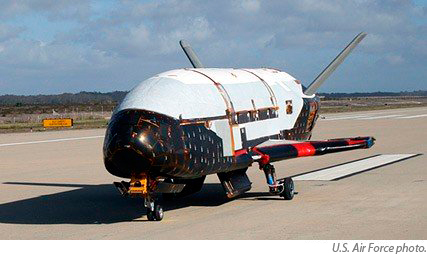
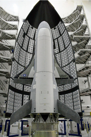
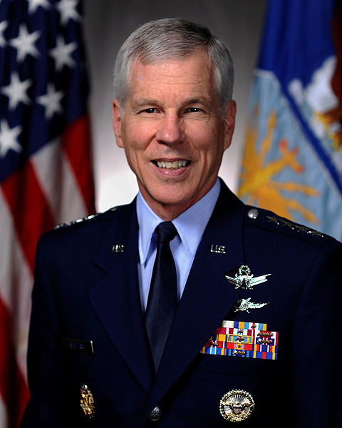
 This column rarely covers privacy as a critical issue to build location-based services markets. Why? It was our contention that most LBS are opt-in — or opt out — at the discretion of the consumer, making privacy an important issue, but not a market stopper. Frankly, many privacy panels at location conferences either bordered on hysteria, or were not relevant to market growth. However, since the recent Where 2.0 conference, which revealed that some entities were storing location information without users’ permission, the privacy issue has the potential of suppressing products and markets before they even start. Some are dubbing this new privacy concern Locationgate.