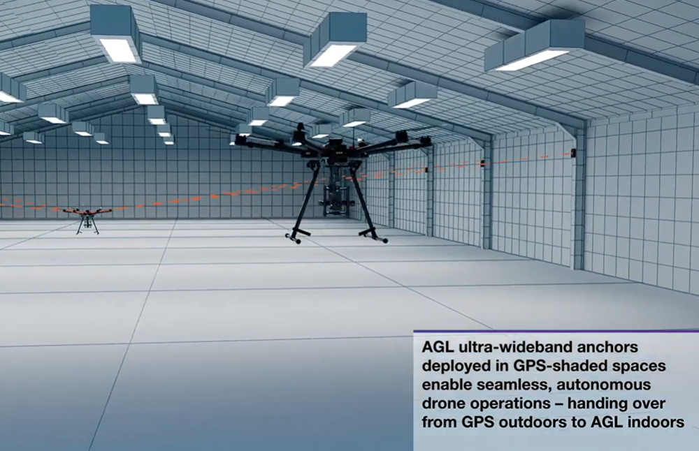
Belgium company Agilica is offering a GNSS-independent onboard positioning system using ultra-wideband (UWB) technology. The system enables precise, autonomous drone navigation and landing, even in dynamic, GNSS-denied environments or on moving targets.
The company says the system achieves centimeter accuracy in real time, enhancing safety and precision. It supports multiple drones and mobile assets in dynamic conditions.
Developed in 2018 as a research and development initiative at the Royal Military Academy in Brussels, Agilica has evolved into a company focused on developing high-accuracy positioning and navigation solutions for drone and robotic applications.
1Spatial, a location master data management (LMDM) software and solutions provider, has secured a three-year contract with a leading Distribution System Operator for electricity and gas networks in Belgium. 1Sparial plans to support the utility company in developing a digital twin for its distribution network, with a focus on enhancing the quality and precision of its geospatial data.
The contract is for geospatial data processing services. 1Spatial’s 1Integrate will be used for data quality control, validation and geospatial data production services.
The project will allow the utility company to efficiently manage distribution networks and make connections and repairs while ensuring safety.
The total contract value to 1Spatial is €9 million, of which 1Spatial will deliver €4.1 million including €0.3 million in term software license revenue. 1Spatial will utilize partners to deliver the balance of the work, with a total value of €4.9 million, over the three-year duration of the contract.
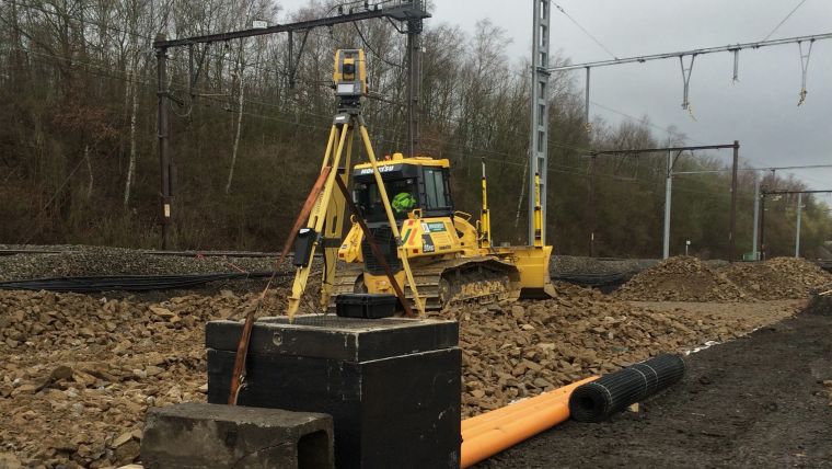
Belgian government-owned railway company, Infrabel, is responsible for ensuring that the country’s railway systems run smoothly. To do this, the company recently needed to renew the switches and crossings at the Kinkempois site, located in the Liege region of the country.
To ensure an efficient, safe and high-quality changeover, Infrabel partnered with construction specialist Jérouville, and when it came to choosing technology to help guide its machinery, the contractor turned to Topcon Positioning for its total station solutions.
According to Stéphane Lemaire, equipment manager at Jérouville, the team first dismantled and removed the previous set of foundations and the sub-foundations at Kinkempois. From there, the team installed new foundations to ensure the new switches have a good grounding for years to come.
At the site, navigation capabilities were compromised due to interference from overhead power lines. As a resolution, two Topcon total stations were used; one for each crawler dozer. Despite the challenging circumstances, the total stations were able to provide accurate readings for each dozer.
Before the bulldozers could get to work, surveyors used the data from the total stations to create three-dimensional models of the finished project using Topcon’s MAGNET software. These models were then shared with all stakeholders on the project. The MAGNET software allowed the entire team to have complete oversight of the project, whether they were on-site or back in the office.
Stéphane Lemaire said in a press release that Topcon’s total stations played a key role in getting the job done accurately on the first try.
“Traditionally, this has been a time-consuming process for projects like this, with a tracker on site who would manually ensure that the levels were correct,” Lemaire said. “However, with total station technology, the process only took three shifts across two weekends, compared to six shifts across two weekends.”
LEUVEN is a city with a bustling atmosphere full of shops, restarants and more. The culturally rich city is inhabited by more than 100,000 people — 60,000 of them being students. (Image: lavio Vallenari/iStock Unreleased/Getty Images)
Follow the cobblestone road through the narrow streets of Leuven, Belgium, and you will likely come out to the medieval-looking main square surrounded by a gothic church, lavishly architected restaurants and the breathtaking city hall, ornamented by hundreds of historical statues. Don’t let it fool you — this culturally rich city produces some of the most cutting-edge technology today, right next to the world-famous Stella Artois beer factory. In fact, Leuven was named as the European Capital of Innovation by the EU Council in 2020.
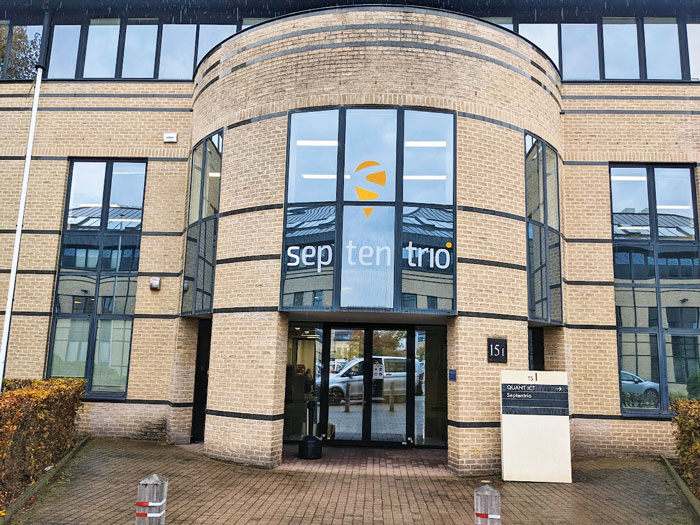
In this city is the headquarter of Septentrio, a manufacturer of high-precision GNSS positioning solutions and a fast growing company. Septentrio’s recently launched products, including the compact mosaic-X5 GNSS module and AsteRx-i3 GNSS/INS OEM board, are further fueling its growth and market share gains.
There is an intricate link between the city of Leuven, its university, and the high-tech industry that results in such a bubbling cauldron of innovation. The powerful synergy between the university and the city makes Leuven unique. Established in 1425, the Catholic University of Leuven (KU Leuven) is one of the oldest universities in Europe. It uniquely combines a very high standard of education with openness and inclusiveness.
This combination of excellence and inclusiveness is rather unique, as most top-quality universities have a more exclusive approach. While ranked as one of the top universities by Reuters, KU Leuven is accessible to students from around the world and actively collaborates with industry players in the surrounding area. At the same time, Leuven’s local government enables and supports the university with housing, student life, events, grants and more. With more than 150 nationalities living in Leuven, the city is a hotspot of diversity in terms of cultural background, experience and talent.
SEPTENTRIO headquaters is nestled near KU Leuven University — one of Europe’s top sources for talent in the areas of signal processing and advanced algorithms. (Image: Matteo Luccio)
As early as 1972, the university established the Leuven Research and Development Tech Transfer office, to valorize know-how. Since then, hundreds of spin-offs have emerged and settled in the Leuven area, including the Haasrode Research-Park, where 12,000 professionals work today and where Septentrio is situated.
Another important player tightly linking KU Leuven and the industry is the IMEC research center. IMEC is the world’s largest independent research center dedicated to semiconductor technology, housing the most advanced wafer fab equipment and employing more than 5,000 researchers. It has more than 4,000 active patents today. As the chairman of its board, I can personally vouch for IMEC as a center of excellence, with the highest standards for quality, fueled by the most talented post-graduates of KU Leuven and professionals from all around the world. For example, IMEC has recently built a new clean room, totaling 12,000 square meters, operating 24/7 to produce next-generation integrated circuit technology and nanoelectronics. Once a new idea or technology is identified, it is sometimes spun-off as a company. That’s exactly how Septentrio started 22 years ago, and it still works very closely with IMEC as a partner and a source of talent for semiconductor and hardware development.
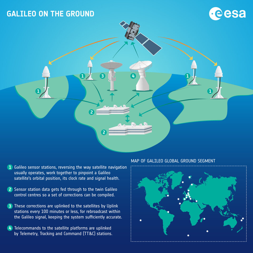
Another key partner of Septentrio is the European Space Agency (ESA), which enables us to be at the forefront with the latest GNSS technology. From the very inception of Galileo, the European GNSS constellation, ESA has given us the opportunity to be involved as the developer of the Test User Receiver, which acquired the very first signals. Septentrio has also been providing reference receivers for the ground segment of the European Geostationary Navigation Overlay Service (EGNOS), which is Europe’s regional satellite-based augmentation system (SBAS), aimed at providing higher accuracy positioning for airplanes. Working with ESA as a strategic partner allowed us to gain the expertise and insights needed to be the first to market with many key technologies, for example the Open Service Navigation Message Authentication (OSNMA) anti-spoofing authentication on the mosaic module.
Our strategic partnership with ESA and close collaboration with the IMEC semiconductor technology hub has enabled Septentrio to produce mosaic-X5. This compact module is one of the highest performing and resilient GNSS receivers on the market. It is used in a wide array of applications, especially where the position is mission-critical. Examples include a wide variety of autonomous devices, including UAVs that benefit from mosaic’s lightweight and low-power design. The mosaic-H provides accurate heading and is used in applications such as faster set-up and directing of 5G telecom antennas
In short, Leuven offers us an exciting and innovative working environment, as we continue to push out the limits of technology to deliver better solutions to our customers.
The European Space Agency (ESA) Academy is requesting university students to apply for the pilot edition of the Navigation Training Course. The course will take place June 26-30 at ESA Academy’s Training and Learning Facility in ESEC-Galaxia, Belgium.
With a specific focus on Galileo, the ESA Academy course aims to provide university students with an introduction to satellite navigation. Designed by ESA experts that developed the Galileo space and ground segment, this training course will offer students fundamental knowledge of Galileo’s architecture, tools, services and functionalities.
The training course will include lectures and hands-on exercises with a tour of Galileo in-orbit test facilities in ESEC, which provides an essential part of the current Galileo ground segment.
Upon completion of the training course, students will be evaluated and will receive a certificate of participation and course transcript, allowing them to request ECTS credits from their respective universities.
For more information and application requirements, visit the ESA website.
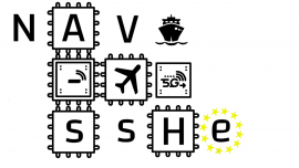
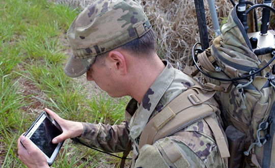
The Navigation Sensor Switching in Hostile Environments (NAV-SSHE) project aims to design, prototype and demonstrate new solutions for positioning, navigation and timing using 5G plus GNSS for critical applications in hostile environments. NAV-SSHE is supported by the European Space Agency (ESA).
Geolocation company M3 Systems Belgium is taking part in the project in collaboration with Telespazio Belgium. The project began in September 2021 and will last until January 2023.
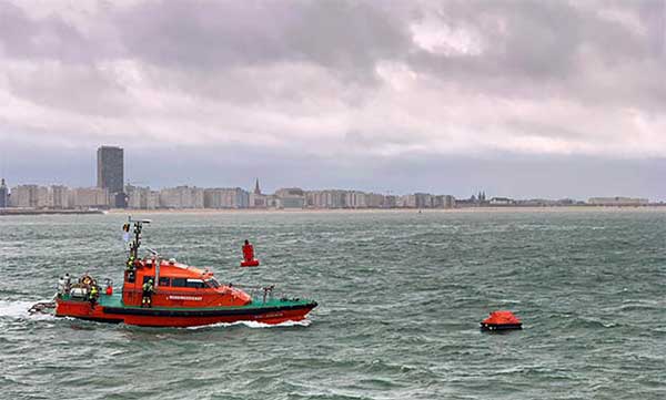
In the context of NAV-SSHE, M3 Systems Belgium will implement both a GNSS and a 5G signal based on positioning engines. The output of both engines will be fused to provide a unique solution with increased robustness.
The complete system will be demonstrated on two real-use cases:
autonomous vehicles on an airport platform (specifically autonomous lawn mowers)
autonomous docking of vessels in port
The demonstrations will also be used to test potential use of these technologies for drone applications — specifically for the navigation system of the autonomous remotely piloted aircraft Boreal.
A crucial step toward the development of the Galileo Public Regulated Service (PRS) military user segment took place Monday, Feb. 8, with the kick-off meeting in Brussels of the GEODE (GalilEO for EU DEfence) project, according to a press release from FDC.
GEODE is the biggest Galileo application development project ever launched.
Sponsored by Belgium, Germany, Italy, France and Spain — contributions should exceed 82.7 million euros — GEODE is supported by the EU with a grant of about 44 million euros. The ambitious defence-cooperation project is under the umbrella of the European Defence Industrial Development Programme (EDIDP) of the European Commission.
GEODE will establish the framework for developing the Galileo PRS user segment for defense applications. At kick-off, the project involved 30 companies and organizations from 14 EU Member States: Belgium, Czech Republic, Estonia, Finland, France, Germany, Greece, Italy, the Netherlands, Poland, Portugal, Spain, Sweden and Romania.
The GEODE Roadmap
National defense organizations — in close cooperation with industry — have defined a roadmap for the Galileo PRS military user segment development, beginning with a specification and standardization phase. GEODE will prototype, test and qualify
seven PRS security modules developed from various technologies
nine PRS receivers (including two server-based variants)
four GPS/Galileo PRS-compatible anti-jamming controlled radiation pattern antennas (CRPA).
A common and standardized test environment will be developed as well as a PRS infrastructure to ensure the availability of the security assets for operational testing.
Finally, military operational field testing will be organized on military platforms (naval, land and drones) and timing and synchronization systems in (at least) Belgium, Czech Republic, France, Germany, Greece and Romania.
A PRS solution for spacecraft will also be designed and prototyped.
Beyond paving the way for the equipment of EU Member States defense forces with Galileo PRS, the military user segment that is developed, tested and certified under GEODE is planned to be available for export to other countries that have the necessary PRS security agreements with the EU.
The GEODE project will be completed in 2026.
Plans are for GEODE to
boost EU competitiveness in the highly strategic domain of military positioning, timing and synchronization.
foster the equipment of EU Member States’ military forces with Galileo PRS capability, essential to reinforce their interoperability and autonomy.
facilitate access to complex security-certified technologies and make them affordable through means of standardization and by creating the necessary critical mass.
In brief, the project will bolster EU Member States’ military capability, create business opportunities for the EU industry in the field of military application of satellite navigation, and maximize the benefits of the Galileo programme by energizing the adoption of its PRS service in all EU Member States and beyond.
Background on GEODE
This project has received funding from the European Defence Industrial Development Programme (EDIDP) under grant agreement No 039.
The GEODE industrial consortium is led by FDC and comprises the major industry players of the field: Airbus Defence and Space, Antwerp Space, Cy4gate, Diehl Defence, Elettronica, Fraunhofer Institute for Integrated Circuits IIS, GMV Aerospace and Defense, Indra Sistemas, Safran Electronics and Defense, Leonardo, Siemens Aktiengesellshaft, Orolia, Tecnobit, Telespazio, Thales Alenia Space Italia, Thales AVS France, Thales SIX GTS France, accompanied with 12 other EU companies acting as subcontractors (c.f. picture hereafter).
The GEODE project is developed in the context of the European Radio-navigation Solution (EURAS) project of the Permanent Structure Cooperation (PESCO). The EURAS project aims at promoting the development of EU military positioning, navigation and timing) capabilities and future cooperation taking advantage of Galileo and the PRS.
Operation Shark Bait showed how this vital service can quickly trigger a rescue operation and save lives at sea. Despite a grey day and choppy sea conditions, an emergency rescue was initiated in just over three and a half minutes after intrepid “volunteer victim,” Australian broadcaster and explorer Tara Foster, operated her Galileo-enabled SAR beacon from a small life raft buffeted by the waves just offshore from the port of Ostend.
Operation Shark Bait was a specially designed demonstration of the capabilities of the Galileo SAR service that took place around the new state-of-the-art Belgian Maritime Rescue and Coordination Centre (MRCC) in Ostend with an invited audience of VIPs and media. The whole operation was streamed live over YouTube and the Europe By Satellite (EBS) TV service.
The Shark Bait test took just over three and a half minutes to locate the PLB developed under a GSA Horizon 2020 project. (Photo: GSA)
The scenario was simple. Tara was left alone at sea in a small life raft, but with a 406-MHz Cospas-Sarsat personal locator beacon (PLB). On activating the beacon, the stopwatch started. The time to receive the distress signal, compute her position and alert the relevant rescue authorities was recorded. The Belgian fast rescue boat ORKA R6 then dashed out to sea to pick her up.
Subsequently, a NH90 Cayman SAR helicopter from the Belgian 40th squadron was also scrambled to help transfer “injured” Tara to hospital.
Shark Bait was a great success with just 3 minutes 32 seconds elapsing from Tara activating her Galileo-enabled personal locator beacon (PLB) to the moment commanders at MRCC could dispatch the ORKA to her location.
The location, with an initial accuracy of 100 metres, is provided by the Galileo receiver inside the PLB to the Galileo satellites in view. The Galileo satellites then forward this information to the Cospas-Sarsat infrastructure, where the position is validated.
“The PLB used was developed under one of our Horizon 2020 projects and is the first Galileo-enabled beacon on the market,” said Fiammetta Diani, head of market development at the GSA.
Time saver, life saver
The day started at the MRCC in Ostend with a visit to the operations centre, an inspection of the ORKA Fast Rescue Boat and a chance to talk to Tara Foster before she was “castaway” on the waves.
Dries Boodts, deputy nautical director at MRCC, described the role of the center, which has a single focus on safety at sea. “The globe is divided into Search and Rescue Regions (SRRs),” Boodts said. “The MRCC oversees the Belgian maritime region that extends up to 47 miles off the Belgian coast.”
The region includes major shipping lanes and two large offshore wind energy parks. The MRCC deals with around 450 incidents each year involving a range of craft and issues from collisions at sea to war munitions recovery. It can call on an assortment of assets including its own rescue craft, police and navy vessels and the Belgian air force and the MRCC collaborates extensively with authorities in neighbouring countries.
Galileo is Europe’s contribution to upgrading Cospas-Sarsat, the global satellite-based search-and-rescue system. Since its introduction in 1981, Cospas-Sarsat is estimated to have saved 45,000 lives.
The current MEOSAR (Mid-Earth Orbit Search and Rescue) upgrade is based on the EU’s Galileo satellite constellation that carries a dedicated Cospas-Sarsat payload for the 406-MHz distress beacons that give users free access to global system.
The addition of Galileo (and other GNSS satellites) to the system has already enabled a dramatic increase in performance in terms of better accuracy to locate activated distress beacons and vastly improved global coverage.
“With the Galileo system, all parts of the world will be covered at least every 10 minutes — previously this was up to four hours — and guaranteed location accuracy is reduced from 10 to 2 kilometers,” explained Jolanda van Eijndthoven from the European Commission.
As well as the 23 SAR payloads currently provided by Galileo, with more to come, the EU also provides ground infrastructure including MEO Local User Terminals (LUTs) to pick up the signals relayed from the satellites. These LUTs are not just in Europe, and a fourth facility is o be opened soon on La Reunion island to improve coverage across the Indian Ocean.
Return link reassurance
From the end of the year the Galileo system will also provide a Return Link Service (RLS) that will be able to send an acknowledgement to the victim that their distress signal has been received and help is on its way. This new ability to provide reassurance should deliver a valuable psychological lift to victims and further boost survival rates.
“The PLBs developed under our Horizon 2020 projects will be the first ones on the market to have the RLS capability,” said Fiammetta Diani.
Back on dry land, Tara confessed that the simulation had felt very real to her. “The scariest part was the transfer to the helicopter from the rescue boat,” she said. “The winch was like a lift without a floor and very fast! Stepping from the flimsy life raft to the ORKA was also not easy – those waves were high!”
“The operation went just like clockwork,” concluded Paul Flament Head of the Galileo and EGNOS unit at the European Commission’s DG GROW.
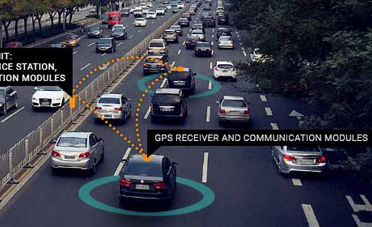
Belgium has launched its first smart highway test environment. Septentrio GPS/GNSS receivers are integrated into vehicles and infrastructure to provide dependable, high-accuracy positioning and to aid sensor fusion in driverless navigation and truck platooning.
Septentrio’s high-precision GPS/GNSS technology will be one of the key components in a Smart Highway system, which launched April 8 with a live demonstration in Antwerp, Belgium. A section of a highway will be dedicated as a test environment for technology which prepares Belgium for automated driving and truck platooning.
When vehicles are aware of each other’s position and velocity, road efficiency and safety can be significantly improved by smoothing traffic flow and automatically breaking if slowing traffic is detected ahead.
Roadside units along the highway will feature GNSS receivers acting as reference stations, sending out continuous positioning corrections. Onboard GNSS units will use these corrections together with built-in quality indicators to calculate trustworthy, sub-decimeter positioning. They will also provide precise timing for syncing the multitude of sensors onboard these “smart vehicles.”
“We are excited to be a part of the Smart Highway testbed which is aimed at improving road safety and traffic flow,” said Jan Van Hees, business development director at Septentrio. “The automotive ecosystem is undergoing a shift towards automation enabled by the latest technology in communications, sensors and precise positioning. Our role in this project builds upon our strategy to continue providing high-accuracy, reliable positioning solutions aimed at the automotive industry.”
The Advanced Interference Mitigation (AIM+) technology shields Septentrio receivers from interference. On a highway, an increasing number of trucks are equipped with illegal jamming devices to avoid road tolling. These jamming devices can interfere with GPS signals used by other vehicles and infrastructure.
Smart Highway is a project of the Flemish government coordinated by imec, a world-renowned research and innovation hub of nano-electronics and digital technology. Septentrio, Toyota, Ericsson and Telenet are contributing industry partners for the project, while UAntwerpen, UGent and others are research partners.
On the European level, the CONCORDA project supports research and development of automated vehicle technology and infrastructure in Germany, Spain, France, Netherlands and Belgium.