The Institute of Navigation (ION) will be hosting a complimentary webinar, “Impact of Sample Correlation on SISRE Overbound for ARAIM,” at 12 p.m. ET on May 28.
This topic was originally presented at ION GNSS+ 2018 and published in the Spring 2020 issue of Navigation, Journal of the Institute of Navigation, Volume 67, No. 1, pp 197-212, by Dr. Santiago Perea Diaz, Prof. Michael Meurer and Dr. Boris Pervan.
According to ION, this paper analyzes the effect of error correlation on the SISRE bounding for GPS and Galileo satellites. For a given period of data collection, it computes the effective number of independent samples contained in a dataset applying an estimation variance analyses. Results show that the time between effective independent samples is highly dependent on the constellation and onboard clock type. On one hand, GPS satellites equipped with Rubidium clocks exhibit significantly longer error correlation than those with onboard Cesium clocks. On the other hand, Galileo satellites show substantially shorter correlation time among samples with less variability on a monthly basis, ION added.
This paper also introduces a methodology to compute SISRE bounding accounting for the limited number of independent samples, ION said. Using a Bayesian approach, it computes the so-called uncertainty factor by which the Gaussian distribution needs to be inflated in order to account for the observation data independence.
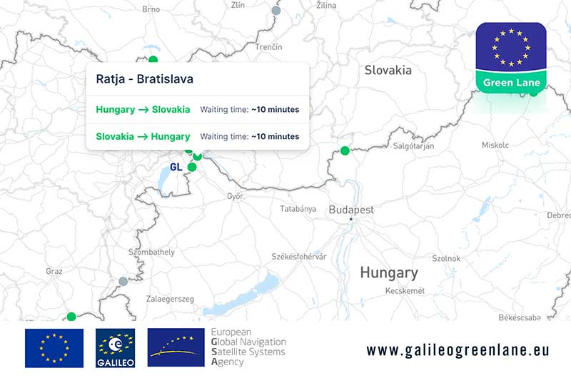
The European GNSS Agency (GSA) has collaborated with the European Commission to develop the Galileo Green Lane app, a mobile solution designed to facilitate the free movement of freight, reduce waiting times at European Union (EU) borders and prioritize essential goods during the COVID-19 pandemic response.
According to GSA, for border control authorities, the app provides a real-time visualization of the situation at border crossings, along with regular updates on the traffic flow situation.
For truck drivers, the app provides a real-time visualization of borders, through an EU-wide map indicating crossing times. This enables logistic companies and drivers to better prepare their routes, having advance knowledge of the waiting time at each border crossing, GSA said.
The app also offers a real-time overview of border traffic hold-ups, built on the foundation of Sixfold’s COVID-19 map. In mid-March, Sixfold began to provide supply chains, retailers and shippers with a free live border crossing map, which is updated in real-time.
“With the Galileo Green Lane app, the GSA is fulfilling its mission to address economic and societal challenges by leveraging the European GNSS capabilities,” said Pascal Claudel, acting executive director at the GSA.
The app has been tested at border crossings in Hungary and the Czech Republic, while other countries, including France, Greece, Italy, Romania and Spain, are about to start testing, GSA added.
Esri will be providing a COVID-19 Response Package for free to all nonprofit organizations responding to the pandemic. According to Esri, this includes data, templates and solutions that are accessible through Esri’s Disaster Response Program.
By mapping data with capabilities such as spatial analysis, Esri’s software allows organizations to track where COVID-19 cases are spreading, and — through predictive modeling — determine where additional capacity will be needed. Using data visualization in maps and dashboards, nonprofits can see affected populations, share information with stakeholders virtually and measure the impact of their response efforts, Esri said.
“Esri enables us to identify vulnerable communities, whether they currently have unmet needs or appear to have a thin cushion with which to absorb a crisis,” said Raj Kamachee, Team Rubicon CTO and CIO. “Thanks to this wealth of location-based data, we have responded not only reactively, but have also been able to reach out proactively to these vulnerable communities, establishing a relationship during ‘blue skies’ so they have someone to call when disaster strikes.”
According to Esri, it has supported more than 10,000 nonprofits to advance their missions with geospatial data and tools through the Esri Nonprofit Program, which was launched in 2010.
“It’s never been more critical to ensure that nonprofits have the solutions that will enable them to target and serve vulnerable populations, understand disease spread, gauge their effectiveness and engage their communities,” said Jack Dangermond, Esri founder and president. “Our company was founded as a nonprofit, and so we share a deep commitment to the goals and mission that these organizations pursue.”
Founded in 1969, Esri provides geographic information system software, location intelligence, and mapping.
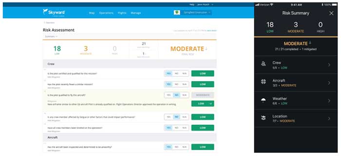
Skyward has released a new risk assessment tool for its Aviation Management Platform, which is designed to help drone program managers proactively identify and document critical risks to an operation.
For assessing risk, users answer a series of risk questions developed by Skyward’s drone experts and based on aviation best practices. Each answer is assigned a risk level: low, moderate or high. As each question is answered, an overall risk summary score is generated based on the highest level of risk present, Skyward said.
Photo: Skyward
Users can also add mitigation for any risk level by adding explanations and adjusting the risk levels. The mitigated risk will be noted in the summary, and the note will be synced across the Skyward software platform.
Skyward, based in Portland, Oregon, develops drone programs for industries such as construction, industrial inspection, media, insurance, real estate, mining, precision agriculture and more. Skyward was acquired by Verizon in 2017.
At Intergeo 2019, Torsten Müller, general manager at eEntwicklung.net GmbH, discusses how eEntwicklung.net and Sokkia have partnered for a stake-out solution.
The show was originally scheduled to take place May 4-7 in Boston. It was then postponed to tentatively take place Aug. 10-12 in Boston. Because AUVSI was unable to secure the original location for the new dates, the trade show has been moved to the Kay Bailey Hutchison Convention Center in Dallas.
“While we are disappointed to leave Boston, we are excited to confirm that we will be once again hosting Xponential in Dallas, Texas,” said Brian Wynne, president and CEO of AUVSI. “We anticipate great participation based on the attendance and engagement we experienced there in 2017, and our AUVSI Lone Star Chapter has already extended a warm welcome on behalf of the Texas unmanned systems community.”
According to AUVSI, it based its decision to reschedule to the fall on concerns for the health and safety of the attendees of the trade show because of the coronavirus pandemic.
“For 48 years we have witnessed how innovation and resolve meet challenges head-on to reshape critical missions and business operations for the better,” Wynne said. “Our commitment to supporting the unmanned systems community remains unwavering, so amidst the current global health crisis we, too, must adapt to fulfill that mission.”
AUVSI also will implement a health and safety plan to address social distancing and other measures to help keep participants safe, the association said.
The AUVSI Xponential trade show highlights advancement of businesses and technologies in the unmanned systems industry.
According to the company, the week President Donald Trump declared a national state of emergency marked a major shift in human activity.
Garmin data pointed to a massive decline in the overall number of steps taken during the second two weeks of March in the U.S. This trend is consistent with the company’s global trend data in China, Italy and other countries where the coronavirus pandemic struck first.
“We’re observing a remarkable shift in the types of activities people are doing, reflecting an unprecedented about-face when it comes to typical springtime exercise and activity,” Garmin said in a blog post.
To paint a clear picture of the initial trends, Garmin engineers and data analysts looked at the percent change in activity levels in the United States for specific sports and exercises and compared the first half of March with the second half of March to determine increases and decreases. The results also are baselined against the same time period in 2019.
Here’s an overview of how activity has changed.
Skiing and snowboarding: These activities are down 96%. This aligns with resorts closing because of the pandemic.
Cycling: Virtual cycling activity was up 64% in the second half of the month, a shift that appears even more atypical when comparing it to the same time period last year. March 2019 saw a 20% decline in the activity as cyclists naturally began to take their rides outside to enjoy the warmer weather, Garmin said.
Indoor/treadmill running: Indoor/treadmill running is down 44%. According to Garmin, this doesn’t mean this activity has come to a halt. Because gyms across the country are closed, a number of treadmills aren’t being used. In fact, virtual running saw a steep increase in the second half of March, and despite gym closures, overall indoor cardio is holding strong over 2019 levels and showing an 18% week-over-week increase from March 16 to March 30. This suggests more people are exercising, and they’re finding ways to do it from home, with and without their own equipment, Garmin said.
Lap swimming: Lap swimming is down 88%.
Walking: Walking is up 36% when comparing the front half of March to the back half of March. This surge is double the 18% increase observed over the same time period last year, Garmin reported.
Yoga: Garmin wearable device data shows an 11% increase in yoga activity, when comparing the front and back halves of the month. This is an increase in 2019 data, as well.
Golf: Golf has seen a 20% decline in activity for the second half of March. When comparing the same two time periods last year, golfing activity increased by 53%.
According to the company, Trimble Dimensions is the signature event for Trimble’s global user community spanning agriculture, construction, geospatial, transportation, utilities and more. The show highlights technology and how it transforms the way professionals work to achieve success.
“Unfortunately, the overwhelming concerns and ongoing impact of COVID-19 inhibit our ability to deliver a conference that meets the high standards of safety and excellence our attendees expect and deserve,” Trimble said in a press release.
The event was scheduled to take place Nov. 2-4 at the Gaylord Opryland Resort and Convention Center in Nashville, Tennessee. Trimble Dimensions is a biennial event.
According to AUVSI, the series will offer information, insights and insider knowledge covering a number of topics, including drone delivery, public safety, connectivity, and other aspects of the unmanned systems and robotics industry.
These webinars are being held because of the rescheduled Xponential 2020 conference. Xponential 2020 was originally scheduled to take place May 4-8 in Boston, but is now tentatively scheduled to take place Aug. 9-12.
AUVSI offered an overview of the webinars, which are all complimentary.
Digital Twins — The Future of Virtual and Mixed Reality Robotic Avatars Date: Monday, May 4, 3-4 p.m. EDT Speaker: Peter Haas, associate director, Humanity Centered Robotics Initiative, Brown University
Hass will describe how advances in mixed and virtual reality control will lead to a UX revolution for avatar-based robotic teleoperation, where the manipulation of digital twins will translate to manipulation of a robot — or robots — in the physical world. Register here.
Drone Delivery Supporting Public Health Date: Tuesday, May 5, 3-4 p.m. EDT Speakers: Eric Gardiner and Eric Lasker, federal business development, Zipline
Executives from Zipline will describe how drone delivery has evolved through the Federal Aviation Administration UAS Integration Pilot Program and is now being adapted to help community healthcare partners respond to COVID-19 in the United States. Register here.
NASA’s Vision and Role to Enable Urban Air Mobility Date: Wednesday, May 6, 3-4 p.m. EDT Speakers: Robert Pearce, associate administrator, NASA Aeronautics Research Mission Directorate, and Brian Wynne, president and CEO, AUVSI
Pearce will review initiatives to enable small UAS operating at low altitude through a UAS Traffic Management System and large UAS operating in higher altitude airspace with definitive flight experiments to validate key standards, such as detect-and-avoid technology. Wynne will host a discussion with Pearce about his full vision for future aviation, including what the next 50 years has in store for commercial airline travel and urban air mobility. Register here.
Advancing Autonomy Through DARPA Challenge to Benefit First Responders Date: Thursday, May 7, 3-4 p.m. EDT Speaker: Dr. Timothy Chung, program manager, DARPA Tactical Technology Office
DARPA’s Subterranean Challenge engages international teams to deploy autonomous systems — rolling, walking, flying and floating — to remotely map, identify and report on artifacts discovered along underground courses. Chung will discuss persisting challenges with robotics, how teams are succeeding in competition while advancing unmanned capabilities and how these lessons can benefit first responders. Register here.
Aerial Connectivity Joint Activity — Bridging the Gap Between Cellular and Aviation Date: Friday, May 8, 2-3 p.m. Speaker: Mark Davis, technical lead, ACJA
Davis will explore the latest roadmap for aviation and cellular communications, including how recent initiatives such as Aerial Connectivity Joint Activity (ACJA) are aimed at providing a standards framework to enable unmanned aerial cellular. ACJA is a joint activity between GSMA, which represents the interests of mobile operators worldwide, and the Global UTM Association, a non-profit consortium of worldwide Unmanned Aircraft Systems Traffic Management stakeholders. Register here.
An artist’s rendering of a Galileo satellite in orbit (Image: ESA)
News from the European Space Agency
As European governments plan their phased recoveries from the lockdown states triggered by the COVID-19 pandemic, the positioning delivered through satellite navigation is becoming more important than ever before, said the European Space Agency (ESA). Location is a key requirement when attempting to monitor and map the spread of a disease and satnav is one of the main tools supporting this, the agency added.
Since the outbreak of the coronavirus, many applications have been developed that use satnav-based location data to monitor the global spread of the virus and map outbreaks.
For example, Romanian company RISE developed an app called CovTrack, which monitors people in a user’s vicinity made identifiable via Bluetooth connections to the user’s mobile phone and stores the identification data of these devices.
By pressing a button, users can access the database in which the unique identifiers of the mobile phones are registered (without having access to any personal data of these mobile phone users), to verify whether the persons with whom users came in contact have subsequently been confirmed with COVID-19, ESA said. If users have identified a potential contact, they can refer to the relevant authorities whether that contact requires inclusion among the monitored persons, or even testing for COVID-19.
According to ESA, CovTrack, developed on a pro-bono basis, is a spin-off from the existing AGORA project for festival management, supported through ESA’s Navigation Innovation and Support Programme, focused on future navigation technologies.
ESA, along with the European Global Navigation Satellite System Agency (GSA) and European Commission, put together a repository of these apps. The list, based on apps that are already working and available in app stores, includes practical apps that facilitate the daily lives of citizens. Check out the list here.
Europe’s Galileo, currently embedded in over 1.3 billion smartphones and devices worldwide, is helping to increase satnav accuracy and availability, especially in urban areas, ESA added.
In addition, GSA is developing its own Galileo-enabled application, Galileo for Green Lane, to monitor and ease the circulation of goods between European Union (EU) Member States while identifying potential congestion at Green Lane border crossings, thus ensuring EU citizens can access the needed supplies of critical goods.
Drone maker Parrot is supporting French medical professionals facing the COVID-19 pandemic by helping Makers for Life design the MakAir respirator. This partnership comes as a part of their MakAir open source respirator project.
According to Parrot, it will be offering 500 engines for the launch of the MakAir project and will ultimately make 5,000 engines for the project. The engines will offer constant power, controlled vibrations, sufficient reliability and endurance to allow 24/7 operation for six weeks, Parrot added.
The MakAir project came to life when the COVID-19 pandemic highlighted a shortage of artificial respirators. Two other projects joined the cause to alleviate this issue. The first project, which brought together a number of manufacturers, was coordinated by Air Liquide and aims to increase the production of artificial respirators from 200 to 10,000 per year, starting in May 2020.
A second nonprofit project has spurred initiatives to create a simplified artificial respirator from standard components. Quentin Adam of the Makers For Life collective, in collaboration with Professors Antoine Roquilly and Pierre-Antoine Gourraud of the Faculty of Medicine of Nantes, and Erwan L’Her, head of the Intensive Medicine and Care Department of the Brest CHU, proposed a concept for a simplified artificial respirator.
The concept is based on using software to regulate inspiration-expiration, directly with the pneumatic system. The Nantes developer team turned to the CEA for industrialization of the concept, which had already been the subject of a proof of concept at the Brest University Hospital.
Parrot reaches milestone in U.S. Army Short-Range Reconnaissance drone program
Parrot has passed another milestone in the United States Army’s Short Range Reconnaissance drone program. As the final steps of this selection process, Parrot will participate in an operational assessment to support an Army production award decision. In anticipation of an increased demand signal from the Department of Defense, Parrot will start manufacturing prototypes of its dedicated drone in the United States, the company said.
“Parrot is honored to work with the DoD on this highly strategic project,” said Laurent Rouchon, vice president of security and defense at Parrot. “We have successfully met the high standards set over the last 12 months on the prototype efforts, and we look forward to entering this final phase and launching production in the USA.”
The webinars, GeoBits, which are based on the organization’s GeoBytes webinar series, will be free and recorded.
The first webinar, titled “The First GeoBit: Career Opportunities in Land Surveying,” will take place at 2 p.m. Eastern time on April 30. This webinar, hosted by licensed land surveyor Ryan Swingley, will discuss career opportunities in land surveying. Swingley will explain what surveying is and how it affects the physical world around us. The webinar, designed for kids in the eighth to twelvth grades, will cover different career segments in land surveying and the future job outlook. Register for it here.
The second webinar, titled “The Second GeoBit: Studying Population Change using Interactive Mapping Tools,” will take place at 2 p.m. Eastern time on May 5. The webinar, hosted by geographer Joseph Kerski, will Explore how to examine patterns of population change, migration and demography with interactive web maps and web mapping applications. During the webinar, designed for middle school students, Kerski will investigate how 2D and 3D maps can be accessed, modified and turned into online presentations. Register for it here.
The third webinar, titled “The Third GeoBit: Product Management, 3D and maps,” will take place at 2 p.m. Eastern time on May 8. Hosted by Esri Group Product Manager Chris Andrews, the webinar will cover product management and how to guide the development of a product from concept to sale to use by a real-world person to accomplish work. Register for this webinar, targeted for middle school students, here.
Established in 1934, the American Society for Photogrammetry and Remote Sensing is a scientific association serving over 2,000 professional members around the world, providing its members professional development through education and networking experiences, professional certification, publications, scholarships, and other services.