Scientists continue to search for new technologies to serve the PNT mission. One novel way to augment GPS comes from a newly developed technology involving a quantum magnetometer.
Researchers at Lockheed Martin call it Dark Ice; it uses magnetic sensing as an alternative means of determining location without use of satellite signals.
Mike DiMario and his team have developed a prototype magnetometer that uses a synthetic diamond the size of a salt crystal to measure the direction and strength of nearly imperceptible magnetic field anomalies. They overlay that data with maps of Earth’s magnetic field, supplied by the National Oceanic and Atmospheric Association, to produce precise location information.
Special quantum-level impurities in the molecular structure of the diamond, where intermittently a carbon atom drops out and its neighbor is a nitrogen atom, enable the detection of magnetic field waves. These nitrogen vacancy (NV) centers are hyper-sensitive magnetic sensors. When illuminated by a laser, the diamond emits more or less light depending on the surrounding magnetic field’s strength.
The Dark Ice quantum magnetometer measures about 31 centimeters in length. (Image: Lockheed Martin)
Position + Direction. Dark Ice differs from current magnetic sensors aboard ships and planes in that it can measure both the field strength and the direction the field is pointing. “The real advantage of this quantum-based technology is its ability to produce a true magnetic field vector, while at the same time having a very large dynamic range and bandwidth,” DiMario explained.
Project development “was like peeling an onion: with each new layer removed, the team advanced. We had no idea of the expected outcome, other than what system modeling, the laws of physics and good engineering could predict. There was always something we could not have predicted or even thought of.”
In addition to developing this navigational capability, the team has also demonstrated that Dark Ice can harness Earth’s magnetic field to transmit communications across barriers intended to block all traditional signals, and track moving vehicles in real time.
Unjammable. “This project was designed for times when extenuating circumstances might prohibit your use of traditional GPS signals, and you need something that is unjammable, passive and always available. The Earth’s magnetic field meets this description if we can adequately sense and make use of it,” DiMario said.
He wants to downsize Dark Ice to hockey-puck size for convenient use on multiple platforms. “In real-world conditions, if I can get within 200 meters of GPS accuracy, that would be a huge success,” he claimed. Such precision would serve as a backup or verification to GPS, not a sole-means navigation system.
With its powerful sensing capabilities and small size, Dark Ice could function as the most reliable way to do things like identify hard-to-find watercraft in search-and-rescue missions and fly aboard aircraft in the battlefield. Navigation, search and communications — all in one compact sensor.
Orolia, a provider of resilient positioning, navigation and timing (PNT) solutions, announced that its SecureSync time and synchronization servers have been selected to support enroute radar systems across the U.S.
The selection comes as part of the Federal Aviation Administration’s (FAA) move towards a Next Generation Air Transportation System (NextGen). NextGen is about halfway through a multi-year investment and implementation plan.
The FAA plans to keep rolling out NextGen technologies, procedures and policies through 2025/2030 and beyond.
While NextGen will rely heavily upon GNSS to increase capacity, efficiency, and safety in the National Air Space (NAS), many technologies including legacies such as radar will be integrated into the system for maximum robustness to error and disruption.
The FAA employs a variety of radar types for short-, medium- and long-range air traffic control requirements. These diverse radars require different types of timing signals and outputs to suit their operations.
SecureSync. Orolia’s SecureSync provides the necessary timing outputs and signals to meet these requirements. The time server’s ability to provide resilient, accurate and reliable timestamps for the data that it receives from radars is used to quickly organize the data for the aircraft control user interface.
The only time and synchronization device approved by the Defense Information Systems Agency (DISA) for use in U.S. Government networks, Orolia’s SecureSync provides reliability, security and flexibility to synchronize critical aviation operations. SecureSync combines multi-GPS/GNSS signal synchronization, options for alternative signals and BroadShield GPS anti-jamming/spoofing protection for transportation systems. SecureSync combines Orolia’s precision master clock technology and secure network-centric approach with a compact modular hardware design.
The FAA selected Orolia for the competitive program based on its proven timing and synchronization technology and its ability to offer multiple output options as commercial off-the-shelf (COTS) products that do not require additional research and development time or investment.
“Consistently accurate timestamps and the synchronization of thousands of real-time flight data points are essential for safe and efficient enroute air traffic operations,” said Jean-Yves Courtois, CEO of Orolia. “Orolia is proud to support the FAA’s radar data and aircraft control user interface requirements to improve air travel services nationwide.”
More About the SecureSync COTS Product. Built-in time and frequency functions are extended with up to 6 input/output modules. Included with the base unit is a 1PPS timing signal aligned to a 10 MHz frequency signal without any 10 MHz phase discontinuity.
A variety of internal oscillators are available, depending on requirements for holdover and phase noise. On-board clocks synchronize to a variety of external references as standard, factory-installed or upgradable options.
Users may add alternate signals of opportunity to GPS or GNSS input references to improve resilience, or use them for indoor applications and choose from a variety of option cards to add to configuration of timing signals, including additional 1PPS, 10 MHz, time code (IRIG, ASCII, HaveQuick), other frequencies (5 MHz, 2.048 MHz, 1.544 MHz), telecom T1/E1 data rates, multi-network NTP and PTP. Modules can be customized for exact requirements.
To support network time synchronization, SecureSync supports the latest features of network time protocol (NTP) and precision time protocol (PTP, IEEE-1588v2). An optional multi-port NTP configuration allows for operation across 4 isolated LAN segments. Up to 6 PTP ports can be added to operate in various PTP deployments.
SecureSync is a security-hardened network appliance designed to meet rigorous network security standards and best practices. It ensures accurate timing through multiple references, tamper-proof management and extensive logging. Robust network protocols are used to allow for easy but secure configuration.
Features can be enabled or disabled based on network policies. Installation is aided by DHCP (IPv4), AUTOCONF (IPv6), and a front-panel keypad and display. The 1 RU chassis supports multi-GNSS (GPS/ Galileo/GLONASS/BeiDou/QZSS) input.
Options include SAASM, supporting L1/ L2, available for authorized users and required for the US DoD, and BroadShield GPS jamming and spoofing detection. The unit is powered by AC on an IEC60320 connector. DC as back-up, or primary, is available.
Spirent Federal Systems, a provider of GPS/GNSS test equipment, announced that Col. (retired) Bernard Gruber, former program director of what is now the U.S. Air Force GPS Directorate, has joined the company’s board of directors as government security committee chairman. Also joining as the chairman of the board is Robert Lollini.
Spirent Federal President/CEO Ellen Hall stated, “We are happy to have retired Col. Gruber and Bob Lollini joining our dynamic company. We are leading the industry in innovation and quality products for the U.S. government and these two new leaders will help us continue that momentum.”
Col. Bernie Gruber in 2012. (Photo: U.S. Air Force)
Bernard Gruber brings to the position the experience gained from a long and distinguished career in the government and military sector. Mr. Gruber has held several positions in important commands focused on navigation in space, including serving as the chief of Space and Global Integrated Intelligence at the Pentagon from 2009-2010, and director of the Global Positioning System (GPS) at the Los Angeles Air Force Base from 2010-2013. He is currently the director of Precision Guidance and Advanced Programs, Armament Systems at Northrop Grumman.
Robert Lollini is currently the chief executive officer and president of BioFire Defense LLC, a subsidiary and proxy company of bioMerieux. Lollini contributes to the board his broad understanding of strategic financial and executive management.
Spirent Federal Systems was formed in July 2001 by Spirent Communications as a wholly owned subsidiary and U.S. proxy company. Spirent Federal markets and sells Spirent Communications’ GNSS products in North America. The company also provides value-added features and ongoing customer support. Spirent Federal Systems is headquartered in Pleasant Grove, Utah, with support and sales offices throughout the U.S.
Analysis of Satellite Data Exposes Threats to Civil Aviation
The Russian Federation is growing and actively nurturing a comparative advantage in the targeted use and development of GNSS spoofing capabilities to achieve tactical and strategic objectives at home and abroad.
Cover: C4ADS
A new report titled “Above Us Only Stars: Exposing GPS Spoofing in Russia and Syria,” presents findings from a year-long investigation ending in November 2018 on an emerging subset of electronic warfare (EW) activity: the ability to mimic, or spoof, legitimate GNSS signals to manipulate PNT data.
Using publicly available data and commercial technologies, the authors detect and analyze patterns of GNSS spoofing in the Russian Federation, Crimea and Syria. They profile different use cases of current Russian state activity to trace the activity back to basing locations and systems in use.
The report is issued by C4ADS, a Washington, D.C.-based nonprofit organization dedicated to providing data-driven analysis and evidence-based reporting on global conflict and transnational security issues. Its website, c4ads.org,lists transnational organized crime, proliferation networks (rogue nations and non-state actors), threat finance and supply-chain security as areas of focus.
Pinpointing interference. Todd Humphreys, a University of Texas at Austin associate professor and head of the university’s Radionavigation Laboratory, collaborated on the research underpinning the report.
Humphreys stated that, as far as he knew, the study constitutes the first characterization of GNSS interference from space, and cited “some interesting findings:
“Using Automatic Identification System (AIS) data captured by overhead satellites, we monitored spoofing in the Black Sea, around St. Petersburg, Archangelsk, etc., and built a picture of interference activity that spans two years. All such activities occur near Russian coastal waters.
“Correlating this activity with the travel schedule of the Russian head of state, we have strong evidence that the spoofing is a protective measure used to thwart drone attacks on Vladimir Putin.
“By exploiting a software-defined GNSS receiver my lab is operating on the International Space Station, we were able to pinpoint a powerful source of interference, which we found to be coming from the northwest quadrant of a Russian-operated airbase in Syria. This explains the many reports of GNSS interference in the eastern Mediterranean during the past year.”
Global Threat. The tools and methodologies for perpetrating GNSS interference are proliferating at a rapid rate, and the frequency of such incidents around the world increases steadily. GNSS attacks, and GPS attacks specifically, now constitute an active, present, disruptive strategic threat in every theater of operation.
The C4ADS website, in announcing the report, states that “The Russian Federation has a comparative advantage in the targeted use and development of GNSS spoofing capabilities. However, the low cost, commercial availability and ease of deployment of these technologies will empower not only states, but also insurgents, terrorists and criminals in a wide range of destabilizing state-sponsored and non-state illicit networks. GNSS spoofing activities endanger everything from global navigational safety to civilian finance, logistics and communication systems.”
Examining GNSS spoofing events across the entire Russian Federation, its occupied territories and overseas military facilities, the report identifies 9,883 suspected instances across 10 locations that affected 1,311 civilian vessel navigation systems since February 2016. It demonstrates that these activities are much larger in scope, more diverse in geography, and longer in duration than any public reporting suggests to date.
C4ADS believes the Russian Federal Protective Service (FSO) operates mobile systems to support this activity. It chronicles the use of GPS spoofing in active Russian combat zones, particularly Syria, for airspace-denial purposes. This capability is scarcely reported in the public domain. C4ADS identified ongoing activity that poses significant threats to civilian airline GPS systems in the region.
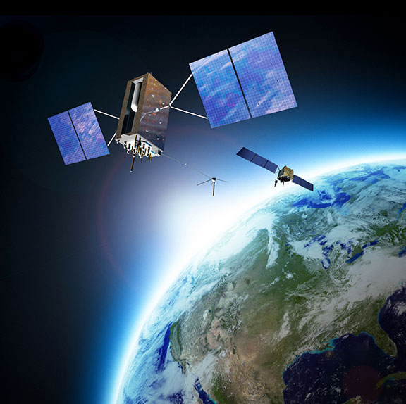
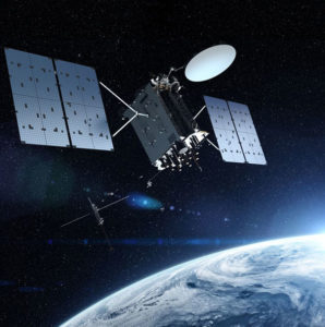
When managed by a new ground control system, GPS III satellites will offer triple the accuracy and eight times the anti-jamming capabilities of the satellites currently comprising the U.S. Air Force’s GPS constellation. Users military and civilian will reap ample benefits.
Everything changed for space-based positioning, navigation and timing around the world on Dec. 23, 2018. Or maybe it didn’t. The innovations heralded by the launch of the first GPS III satellite will take years more to occur. We tabulate here the advances that Generation Three will bring over GPS-to-date, and review the timeline for their actual arrival.
While these new capabilities exist — in concept — in space, they can’t be leveraged on the ground (or in the air, or at sea) until a sufficient number of additional GPS III satellites have joined the constellation, and until a new ground control system comes online. This will occur — perhaps — in 2023. At that time the satellites’ talents will be unleashed.
“As more GPS III satellites join the constellation, it will bring better service at a lower cost to a technology that is now fully woven into the fabric of any modern civilization,” stated Lt. Gen. John Thompson, commander of the U.S. Air Force’s Space and Missile Systems Center and the Air Force’s program executive officer for space.
The many GPS III upgrades should make the service more reliable and accurate for civilians, more secure against those who want to jam military users, and more cyber-secure for everyone.
TALKIN’ ‘BOUT OUR GENERATION
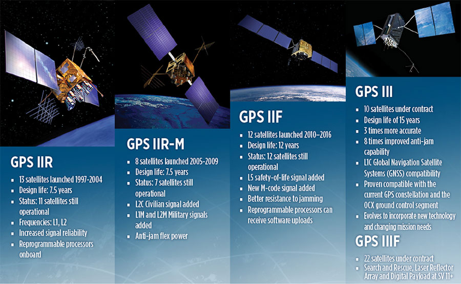
GPS constellations have grown through six major iterations since 1978. The sixth, GPS IIF, rose during the years 2010 to 2016. Those 12 satellites are all designed to last 12 years. Some of their notable features include the ability to receive software uploads, better jamming resistance and increased accuracy.
GPS III, the seventh generation, will launch nine more satellites to join SV01 already in space. GPS III SV02 is scheduled to launch in July of this year, SV03 in late 2019, and SV04 in 2020. The final III payload should rise in 2023. From that point on, the follow-on era of GPS IIIF takes over.
How Long, How Long? “Projections for how long the current constellation will [continue to] be fully capable have increased by nearly two years to June 2021, affording some buffer to offset any additional satellite delays,” reported the Government Accounting Office at the end of 2017. This provided some schedule buffer for launching the first GPS III satellite, but it did not reduce the desire to launch as soon as the booster rocket became available.
The new birds will introduce new capabilities to meet higher demands of both military and civilian users: once filled out, the GPS III constellation will bring three times better accuracy and up to eight times improved anti-jamming capabilities. Spacecraft life requirement will extend to 15 years, 25 percent longer than the latest GPS satellites and twice the original design life of the oldest satellites on orbit today.
The new L1C civil signal broadcast by GPS III is an interoperable signal with other international global navigation satellite systems, like Galileo, improving connectivity for civilian users.
GPS III will eventually actualize full M-code capability — carried aboard the IIR-Ms and IIFs but not yet completely implemented — in support of warfighter operations. GPS III M-code capability exceeds that of GPS IIR-M and GPS IIF.
GPS III will complete the deployment of the L2C civil signal and the L5 safety-of-life signal capabilities that began with \GPS IIR-M and GPS IIF satellites.
Finally, GPS III will enact improved integrity: the ability of the satellite to detect and issue alerts on its own reduced accuracy, should that phenomenon ever occur.
Military Signal Power Up. Encrypted M-code signals will be up to eight times more powerful than currently. This makes them more reliable. but also enables the sats to overcome efforts to jam their signals.
Other signals also offer increased signal power at the Earth’s surface. L1 and L2: −158.5 dBW for aC/A code signal and −161.5 dBW for the P(Y) code signal. L5 will be −154 dBW.
Family Features. The most recent generations of the GPS constellation. IIR, IIR-M and III were produced by Lockheed Martin, while IIF was built by Boeing. One GPS IIA satellite is still in operation, at 25 years young (design life was 7.5 years). All satellites carry Harris Corporation payloads. (Graphic sourced from: Lockheed Martin and Boeing Co.)
L SIGNALS
L2C, the second open GPS signal, after L1 C/A, has been available from every new GPS satellite since the first IIR-M launch in 2005. L5, the third open GPS signal, became available with the first IIF launch in 2010. Now L1C, the fourth open GPS signal, joins the band, broadcasting from every new GPS satellite, starting with the recent GPS III launch (see First Light).
The first GPS III satellite is in checkout and testing that could last up to 18 months before it enters service. “After its Dec. 23 launch, GPS III SV01 successfully completed its orbit raising and deployment of all of its antennas and solar arrays. On Jan. 8, the satellite’s navigation payload began broadcasting navigation signals,” said Johnathon Caldwell, Lockheed Martin vice president for navigation systems. “On-orbit testing continues, but the navigation payload’s capabilities have exceeded expectations and the satellite is operating completely healthy.”
Testing, Testing. Using the Air Force’s Back-to-Basics program, which involved early prototyping and simulations, Lockheed Martin developed GPS III with an approach that involved rigorous quality-build certificates, component testing and system-level testing. The comprehensive requirements verification and validation process ensured more than 30,000 requirements were achieved. The system functional qualification includes the performance verification in multiple environmental tests, including the acoustic, thermal vacuum (TVAC) and electromagnetic spectrum.
“We consider thermal vacuum the gold standard for testing any satellite before it goes into operations,” Col. Steve Whitney, director, GPS Directorate, wrote in GPS World in December. “It really is putting the craft through the paces. When it goes through the testing, the satellite is on. It is working. It is exposing it to the heat and the cold and the zero pressure while the satellite is functional. The entire thermal vac testing from start to end is about 70 days. Test like you fly. From the time it launches and deployment sequence, we test it like it is real. Minus the shaking, the satellite thinks it is getting launched. Meanwhile, our people are looking at the data and its health. TVAC is a huge milestone for a satellite to go through and come out no issues.”
To date, more than 90 percent of parts and materials for all 10 GPS III satellites have been received from more than 250 aerospace companies in 29 states.
BRAIN OF THE BUNCH
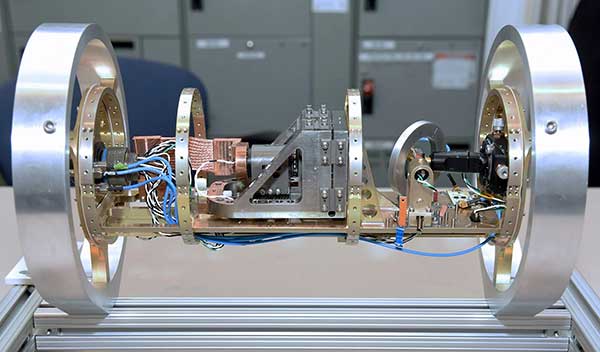
THE FIRST GPS III satellite was fully assembled and entered into SV single-line flow when Lockheed Martin technicians integrated its system module, propulsion core and antenna deck. (Photo: Lockheed Martin)
Harris Corporation is a subcontractor to Lockheed Martin for development and production of GPS III Mission Data Units (MDUs) and transmitters for the GPS space section. Six have been delivered.
The Harris MDU, together with the Atomic Frequency Standards and the L-band transmitter equipment, make up the Navigation Payload Element. The MDU performs the primary mission of the GPS satellite: generation of the navigation signals and data on a continuous basis. The MDU controls the generation of the precise timing signals used for navigation signals while distributing the timing signals to other satellite components.
This MDU is 70 percent digital. The next to come, aboard GPS IIIF satellites, will be fully digital.
When asked about the advantages of an all-digital payload, Harris Corporation’s Jason Hendrix, PNT program director, told GPS World in April 2018, “The advantages and the 30 percent difference are the timekeeping system portion. We’re moving from manual, analog timing to digital to deliver to the Air Force more flexibility. It’s a nice option to have to be able to reprogram in orbit and maybe enhance capabilities desired in the future.”
LIVING BETTER, LIVING LONGER
Greater mission longevity is one of the key improvements GPS III delivers over those currently in service. Space Vehicles 1–10 have a planned mission life of 15 years, 25 percent longer than their predecessors. That begs the question, “How long should a satellite live in space, with technology innovation occurring almost annually?”
Advanced payload technology provides a partial answer. Lockheed Martin and Harris point to new payload capabilities with built-in flexibility to adapt satellites in orbit to technology advances, as well as changes in missions. According to Harris, the fully digital navigation payload will provide the ability to change and upgrade the satellites incrementally over mission life.
In late 2017, Lockheed announced a partnership with NEC Corporation to introduce artificial intelligence for computer learning in orbit. The company touted significant advances in processors and a move toward next-generation antennas, arrays and transmitters to drive more satellite flexibility, capability and resilience.
FROM THE GROUND UP
GPS IIIF’s M-Code can be broadcast from a high-gain directional antenna in a concentrated, high-powered spot beam, in addition to a wide-angle, full-Earth antenna. (Artist rendering: Lockheed Martin)
GPS III’s military upgrades require new ground control stations, a replacement effort called OCX that has suffered repeated delays and cost increases, due to the complexity of the programming and requirements modifications. The new jamming-resistant military signal will not be available until the new, highly complex ground control system is available, and that is not expected until 2022 or 2023. Delay and cost considerations were driven in part by full implementation of all Department of Defense 8500.2 “Defense in Depth” information assurance standards without waivers, giving it the highest level of cybersecurity protections of any DoD space system.
Deliverables for GPS OCX are divided into three blocks. Block 0 delivery took place in fall 2017, enabling it to support the December launch. Block 1 delivery will take place in 2021, providing full operational capability to control both legacy and modernized satellites and signals. Block 2, delivered concurrently with Block 1, adds operational control of L1C and modernized M-code.
In 2018, wrote Col. Whitney of the GPS Directorate, “We have actively utilized the [Block 0] system in a variety of exercises, training events, compatibility tests and launch readiness events. We also completed a comprehensive security review of the system to demonstrate our readiness to start operations. The system is ready to go. We continue to work the development of the OCX Block 1 system and are wrapping up the initial coding of the system early in 2019, leading into our integration and test campaign.”
Given delays in OCX, “the Directorate is actively working two major upgrades to bridge the gap,” Whitney continued. “The first is GPS III Contingency Operations (COps) modification which will allow the 2nd Space Operations Squadron (2SOPS) to command and control the GPS III family of vehicles in a mission state matching today’s legacy signals for all users world-wide. The second modification is M-code early use (MCUE), which enables 2 SOPS to operationalize the Modernized GPS military (M-code) navigation signals for the warfighter.”
Before December’s launch, OCX underwent rigorous cybersecurity vulnerability assessments that tested the system’s ability to defend against both internal and external cyber threats. GPS OCX prevented the broadcast of corrupt navigation and timing data in all tests, bolstering the program’s readiness for GPS III.
“We’ve built a layered defense and implemented all information assurance requirements for the program into this system,” said Dave Wajsgras, president of Raytheon Intelligence, Information and Services. “The cyber threat will always change, so we’ve built OCX to evolve and to make sure it’s always operating at this level of protection.”
The new Harris navigation payload offers a smooth transition to use of OCX. The payload for the first 10 GPS III satellites has been verified for OCX compatibility so the same OCX commands will seamlessly port to the Harris fully digital design, minimizing integration risks and associated costs.
According the the GAO, “Full M-code capability —which includes both the ability to broadcast a signal via satellites and a ground system and user equipment to receive the signal — will take at least a decade once the services are able to deploy military GPS user equipment (MGUE) receivers in sufficient numbers.” The April 2019 issue of GPS World will review M-code implementation across U.S. DoD platforms.
THE FUTURE’S NOT OVER YET
In spring 2018, Lockheed Martin submitted a proposal for the GPS III Follow On (GPS IIIF) program, which will add enhanced capabilities to the satellites. New hardware — a high-gain directional antenna — aims signals in a spot beam at a limited area, but blasts the signal at high power for strategic use by the military.
Inter-Satellite Links. Block IIIF satellites will carry laser retro-reflectors to enable orbit tracking independently of the satellites’ radio signals, which in turn will allow satellite clock errors to be disentangled from ephemeris errors. A standard feature of GLONASS, this is included in the Galileo positioning system, and was flown as an experiment on two older GPS satellites, 35 and 36.
In September 2018, the Air Force selected Lockheed Martin to build up to 22 additional satellites under the GPS IIIF program.
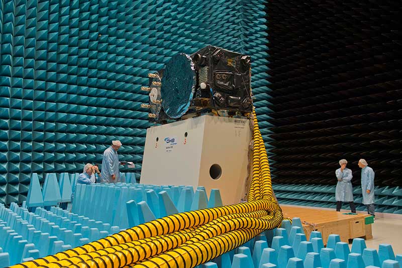
Inside the ESTEC Test Center, Galileo’s First Operational Capability first flight model, FM1, prepares for passive intermodulation testing in the Maxwell electromagnetic facility. (Photo: ESA-Anneke Le Floc’h)
Gazing through soaring plexiglass walls at the space simulation room of the European Space Agency’s Test Center in the Netherlands affords a glimpse into scientific history.
I felt a frisson, a highly regimented frisson if you will, of vicarious thrill for the rigors, rhythms and methods of research and testing as I toured the center after giving a keynote at the agency’s Navigation Days. Here, the final birthing touches were administered to transmitters beaming forth the Second Golden Age of satellite-based navigation.
One can debate which constellation combination will prove most fruitful to users: GPS plus GLONASS, GPS plus BeiDou, GPS plus Galileo (note the common term). I believe it will be the last, because of the close synergy and symbiosis of the two commercial arenas, North America and Europe.
All Galileo Full Operational Capability (FOC) satellites had their mettle and metals probed, radiated, bombarded, shaken and shocked here before they journeyed to space. The test center’s role is to verify, intensively and for months per satellite, that it can perform well for the whole of its planned lifetime.
A mass property test checks that the center of gravity and mass are aligned within design specifications, so that the satellite’s orientation can be accurately and economically controlled with thruster firings in orbit, prolonging work life by conserving propellant.
A five-week thermal-vacuum test runs inside a 4.5-meter diameter stainless steel vacuum chamber, the Phenix. An inner thermal tent heats to simulate solar radiation and cools with liquid nitrogen to create the chill of sunless space.
In the Maxwell test chamber, spiky radio-absorbent anechoic walls test electromagnetic compatibility to ensure that all systems operate together without interference. Noise horns generate more than 140 decibels to simulate a violent launch. A quad shaker table vibrates the satellite up, sideways and down, as accelerometers search for hazardous internal vibration, gathering data across hundreds of channels.
Altogether a severe trial, a crucible from which the FOC satellites emerge certified and ready for space.
Oh, that we humans were similarly tested before placement in positions of power.
Satellites NTS-1, 2 and 3. (Illustration: Lt. Jacob Lutz, AFRL Space Vehicles Directorate)
Just last month we celebrated the kickoff of the GPS III campaign, reporting on the launch of the first space vehicle of that generation in the closing days of 2018. A new era had begun, heralded by a rocket’s blazing path, bearing aloft a new “lighthouse in the sky serving all humankind.”
Turn around and — whoa! Where did all these other new PNT satellites come from?
We attempt to chronicle them all in this issue, though I’m not sure we haven’t still missed some.
For years we’ve been talking about the Iridium constellation, a low-Earth orbit telecommunication network that can also deliver timing services to improve accuracy, and signal acquisition in urban environments. Were it not for the fact that 10 more of its satellites just launched in January, bringing the total of its second-generation NEXT constellation to 75, this would practically qualify as old news.
But let’s move on to the real new news. NTS-3 is the new kid on the block most closely related to the GPS family. In fact, integrally a part of it. This third Navigation Technology Satellite will go even beyond GPS III — whose capabilities, mark you, are not yet online — to investigate new experimental antennas, flexible and secure signals, increased automation and use of commercial ground assets.
Learn about 72 nanosatellites of the Spire constellation piggybacking on Galileo signals to offer GNSS radio occultation products for the weather community. This may not be exactly direct-to-user PNT, but it’s a derivative.
Finally, absorb the latest on Hawkeye 360 formation-flying Pathfinders, designed to detect and geolocate radio frequency (RF) signals, and use the data in search-and-rescue as well as commercial maritime operations.
Don’t stop there! Read about Planet, the breadloaf satellites, current population 300 with more coming, beaming down 1.2 million high-resolution Earthly images per day, useful for agriculture, defense, mapping and GIS, and a few other industries.
If a group of satellites is a constellation, what do you call a group of constellations? If we are to follow astronomy’s lead, I’ve just learned that the proper technical term is an asterism. However, I think galaxy will be easier to handle.
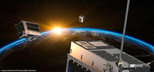
Space Flight Laboratory (SFL) has launched three formation-flying HawkEye 360 Pathfinder 15-kilogram, 20 x 27 x 44-centimeter microsatellites designed to detect and geolocate radio frequency (RF) signals.
Hawkeye 360 Pathfinder satellite trio flies in formation, seeking RF signals from Earth. (Image: UTIAS Space Flight Laboratory)
The target signals emanate from VHF radios, maritime radar systems, automatic identification system (AIS) beacons, very small aperture terminal (VSAT) communication systems and emergency beacons. HawkEye 360 applies advanced RF analytics to the data to assess suspicious vessel activity, survey communication frequency interference and direct search-and-rescue.
Precise formation flying is critical, as the relative position of each satellite must be known to accurately geolocate transmission sources. The satellites carry space-qualified GPS receivers and high-performance attitude control systems to keep them stable in orbit.
Flying in formation, two or all three satellites may receive the same transmission when it originates from their common footprint. The signal’s different times of arrival at each satellite and their different apparent center frequencies (Doppler) will enable onboard comparison of time-of-arrival and frequency-of-arrival measurements to then calculate the transmitter’s position.
The onboard GPS receivers provide precise estimates for the position and velocity of the receivers, information required for multilateration. The satellites further synchronize their clocks using GPS receivers, which also stabilize the phase-locked loops governing the tuning frequency in the RF tuners.
The satellites were built by Deep Space Industries of San Jose, California, and University of Toronto, Institute for Aerospace Studies/Space Flight Laboratory (UTIAS/SFL). They were launched in December 2018 into low-Earth orbit.
Planet (formerly Planet Labs) has put about 300 satellites into space, in charge of photographing the entire land mass of the Earth every day.
The satellites weigh 5 kg (12 pounds) and measure 20 x 20 x 44 centimeters, about the size of a loaf of bread. They are packed with commercial-off-the-shelf electronics and are built in downtown San Francisco. Mission control consists of a single engineer for dozens of satellites.
Aptly named “doves,” the satellites circle the Earth in 90 minutes, their cameras continuously rolling. “It gives you a perspective of the planet as a dynamic and evolving thing that we need to take care of,” said company co-founder Will Marshall.
Each day, the satellites transmit 1.2 million images at a spatial resolution of 3–5 meters, far more than enough to fully occupy all the analysts at the National Geospatial Intelligence Agency (NGA), one of Planet’s more than 200 customers.
Historically, the NGA has relied on three or four very large, very expensive — and to global adversaries, very predictable — spy satellites. The agency has found Planet’s approach intriguing and challenging.
Planet has devised computer algorithms to look for new features day to day, such as roads or buildings th
at may signal activity of a significant or nefarious sort. Other customer uses are more mundane, such as agricultural companies monitoring crop health.
Boundless. In December 2018, Planet entered into an agreement to acquire Boundless Spatial Inc., a St. Louis-based geospatial software solutions company, to further support its commercial business with the U.S. government and agricultural clients.
Elsewhere in this (January) issue you’ll find the hard facts — basic, but hard — concerning the inaugural launch of the long-awaited GPS III constellation. On pages 10 and 12, with some seasoned leavening between, on page 11.
This column instead waxes briefly on the phenomenon of time, and humankind’s struggle to dominate it, to subject the fourth dimension to its own will.
For GPS III has been, yes, long awaited, long debated, long victim to multiple delays of many colors and causes, scrutable and inscrutable, of technological challenges and institutional barriers, and of that base determinant, money. The Government Accounting Office has issued its fair and due share of reports pointing alarmed fingers at constellation gaps and fulfillment shortfalls and the trials of OCX, the ground control system without which GPS III satellites may some day, soon or not-soon, be capable of broadcasting powerful new signals from space, yet not able to do so because of lagging accomplishment on Earth.
It’s often said that GPS is a victim of its own success, that older satellites living beyond their forecast lifetimes have allowed the Air Force to economize by not replenishing when unnecessary. There’s wisdom in this, of course.
Were my friend Don Jewell still with us, he would be justifiably proud of the Air Force for launching this new golden era of the gold standard in positioning — yet he would have seethed for years over the continued pushes to the right.
This reminds me a good deal of the drama and occasional comedy in the rise of Galileo, observed from afar. Next month I’ll give a talk at the European Space Agency, provisionally titled “An Outside History of Galileo,” the bemused viewpoint of one who only heard and interpreted the news, but did not participate in its forming.
For such complex endeavors do not happen easily or speedily or exactly as planned by mere mortals. Nor should they. Despite much gnashing of teeth, no one — in the civil sphere at least — has suffered unduly from the longish delays in either satnav system’s modernization. Perhaps a few lives could have been saved in the military, or greater strategic advantage gained, with the new capabilities that III will offer warfighters, had same been available on schedule, say, four to six years ago. But even this is mere conjecture.
There is a rhythm and a flow to life, and we are part of it. You can hurry neither sundown nor sunrise. Things happen in their own due course.
When full GPS III capabilities arrive — I don’t believe 2023 — then it will still be in good time. In its own best time, actually, to be here.
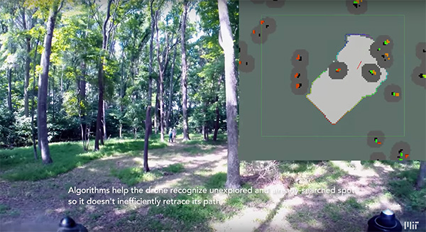
Researchers at the Massachusetts Institute of Technology (MIT) presented a project at the International Symposium on Experimental Robotics involving an autonomous drone fleet system that collaboratively mapped an environment under dense forest canopy.
Designed with search and rescue in mind, the drones used lidar, onboard computation and wireless communication, with no requirement for GPS positioning.
Each drone carries laser-range finders for position estimation, localization and path planning. As it flies, each drone creates its own 3-D map of the terrain. A ground station uses simultaneous localization and mapping (SLAM) technology to combine individual maps from multiple drones into a global 3-D map that can be monitored by operators.
The MIT team tested its concept via simulations of randomly generated forests, and world-tested two drones in a forested area at NASA’s Langley Research Center. In both experiments, each drone mapped a roughly 20-square-meter area in about two to five minutes, while the control system integrated their maps together in real-time.
The drones were programmed to identify multiple trees’ orientations, as recognizing individual trees in impossible for the technology, and individual trees’ orientation very difficult. When the lidar signal returns a cluster of trees, an algorithm calculates the angles and distances between trees to identify the cluster and determine if it has already been identified and mapped, or is a new mini-environment.
The technique also aids in merging maps from the separate drones. When two drones scan the same cluster of trees, the ground station merges the maps by calculating the relative transformation between the drones, and then fusing the individual maps to maintain consistent orientations.
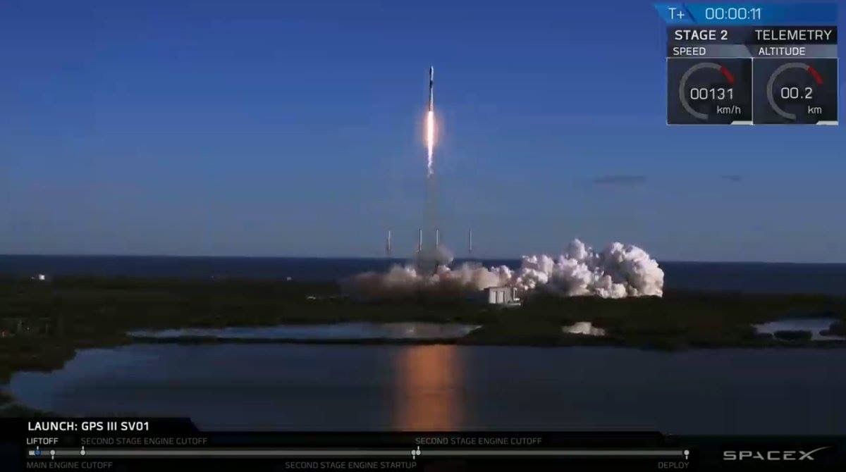
SpaceX’s Falcon 9 rocket orbited the first GPS III satellite on Dec. 23, 2018. (Photo: USAF)
After several launch delays, the first GPS III satellite successfully deployed from a SpaceX Falcon 9 rocket, rising from Cape Canaveral on Dec. 23.
By Jan. 2, the satellite had circularized its orbit at an altitude of 12,550 miles to begin a period of checkout and testing that could last up to 18 months, before entering service. The satellite, built by Lockheed Martin, will serve in space for 15 years.
Known as GPS III SV01 and nicknamed “Vespucci,” it is the first in a new generation of GPS navigation stations with improved services and longer lifetimes to ensure the U.S. military-run network remains available to troops and civil users around the world for decades to come.
“Launch is always a monumental event, and especially so since this is the first GPS satellite of its generation launched on SpaceX’s first national security space mission,” said Lt. Gen. John Thompson, commander of the U.S. Air Force’s Space and Missile Systems Center and the Air Force’s program executive officer for space. “As more GPS III satellites join the constellation, it will bring better service at a lower cost to a technology that is now fully woven into the fabric of any modern civilization.”
The satellite’s earlier scheduled launch date of Dec. 18 was scrubbed, reportedly due to liquid oxygen thermal limit constraints aboard the SpaceX Falcon 9 Block 5 rocket’s first stage reaching safety limits.
A second attempt on Dec. 19 was also ruled out due to ongoing evaluations into the sensor issue. Then ensued three days of weather delay, awaiting favorable wind conditions, until Dec. 23.
After several delays, the first GPS III satellite has successfully deployed from the SpaceX Falcon 9 rocket, which launched from Cape Canaveral Air Force Station in Florida at 8:51 a.m. EST on Dec. 23. (Photo: Lockheed Martin)
GPS III SV01 was originally scheduled to ride aboard a United Launch Alliance (ULA) Delta IV M+ rocket. ULA and its prime partners, Lockheed-Martin and Boeing, have conducted every GPS satellite launch since the start of the program. However, due to an assortment of issues variously involving delayed technology development and lawsuits regarding competitive bidding, the Air Force re-opened the contract process as part of its Evolved Expendable Launch Vehicle (EELV) program — “evolved” signifying that the rocket can be recovered and reused.
Recycling Rockets. ULA did not bid on the re-opened contract, citing concerns over the selection process and potential risks with the anticipated lower launch cost. In 2016, the Air Force selected SpaceX to take over most GPS III launches.
SpaceX’s Falcon 9 for this launch used a new first stage core, the B1054. Although it has re-use capability, it flew in an expendable configuration this time, with no landing legs and no grid fins. It was disposed of into the Atlantic Ocean after separation from the second stage.
In other missions, after the satellite-bearing stage separates from the rest of the rocket, the remaining core launcher fires additional fuel to return intact to land or to sea aboard an Autonomous Spaceport Drone Ship (ASDS), a converted barge awaiting in the Atlantic or Pacific Ocean.
New Generation. The GPS III constellation, once fulfilled, will bring three times better accuracy and up to eight times improved anti-jamming capabilities. Spacecraft life will extend to 15 years, 25 percent longer than GPS satellites on-orbit today. GPS III’s new L1C civil signal also will make it the first GPS satellite broadcasting a compatible signal with other international global navigation satellite systems, like Galileo, improving connectivity for civilian users.
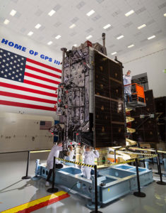
Lockheed Martin developed GPS III and manufactured GPS III SV01 at its GPS III Processing Facility near Denver. In September 2017, the Air Force declared the satellite “Available for Launch” (AFL) and had the company place it into storage.
In 2018, the Air Force called the satellite to Florida, and it was delivered on Aug. 20. At that time, the Air Force declared the second GPS III AFL and in November called it up for 2019 launch. GPS III satellites SV03-08 are now in various stages of assembly and test.