The scheduled launch of the first GPS III satellite on December 18 was scrubbed, reportedly due to first stage liquid oxygen thermal limit constraints aboard the SpaceX Falcon 9 Block 5 launch vehicle’s first stage reaching safety limits. A second attempt on December 19 was later ruled out due to ongoing evaluations into the sensor issue.
The launch window may open again on Dec. 20.
This was to have been the first GPS launch aboard a SpaceX rocket, as well as the first SpaceX contracted U.S. National Security mission.
A Falcon 9 rocket awaits launch. (Photo: SpaceX)
The first GPS III satellite was originally scheduled to ride aboard a United Launch Alliance (ULA) Delta IV M+ rocket. ULA and/or its prime partners, Lockheed-Martin and Boeing, have conducted every GPS satellite launch since the start of the program. However, due to an assortment of issues variously involving delayed technology development and lawsuits regarding competitive bidding, the Air Force re-opened bidding for the contract as part of its Evolved Expendable Launch Vehicle (EELV) program — “evolved” signifying that the rocket can be recovered and reused.
Recycling Rockets. ULA did not bid on the re-opened contract, citing concerns over the selection process and potential risks with the anticipated lower launch cost. In 2016, the Air Force selected SpaceX to take over most GPS III launches.
SpaceX’s Falcon 9 for this launch will use a new first stage core, the B1054. Although it has re-use capability, it will fly in an expendable configuration this time, with no landing legs and no grid fins. It will be disposed of into the Atlantic Ocean after separation from the second stage.
In other missions, after the satellite-bearing stage separates from the rest of the rocket, the remaining core launcher fires additional fuel to return intact to land or to sea aboard an Autonomous Spaceport Drone Ship (ASDS), a converted barge awaiting in the Atlantic or Pacific Ocean.
New Generation of GPS. As attentive readers already know, GPS III SV01 is the first of an entirely new design of GPS satellite that will help the Air Force modernize today’s GPS constellation with new technology and advanced capabilities.
GPS III has three times better accuracy and up to eight times improved anti-jamming capabilities. Spacecraft life will extend to 15 years, 25 percent longer than any of the GPS satellites on-orbit today. GPS III’s new L1C civil signal also will make it the first GPS satellite broadcasting a compatible signal with other international global navigation satellite systems, like Galileo, improving connectivity for civilian users.
Lockheed Martin developed GPS III and manufactured GPS III SV01 at its GPS III Processing Facility near Denver. In September 2017, the Air Force declared the satellite “Available for Launch” (AFL) and had the company place it into storage. In 2018, the Air Force called up the satellite for launch and Lockheed Martin delivered it to Florida on Aug. 20. The Air Force nicknamed the satellite “Vespucci” after Italian explorer, navigator and cartographer Amerigo Vespucci.
GPS III SV01 is the first of 10 GPS III satellites originally ordered by the Air Force. GPS III SV03-08 are now in various stages of assembly and test. In August, the Air Force declared the second GPS III AFL and in November called GPS III SV02 up for 2019 launch.
Changes are in store, and soon to become real. (Isn’t that always the way?) But truly, while continuing to cover every front of GNSS and PNT development, both businesswise and technologywise, we are improving the methods by which we do so. After listening to your input, of course.
Among the questions we asked you in the course of the 2018 State of the GNSS Industry Survey was:
“Please share story ideas with the editors of GPS World and/or let us know if your company is doing something unique.”
Among the answers you gave — here’s where the bit about your future comes in — were these, and here’s some of the content with which we’ll be seeking to fill 2019’s pages:
Using a manned experimental jet aircraft to simulate low observable cruise missiles for countermeasures flight testing.
UAV remote sensing legal issues.
Transitioning from GPS to internal building locating.
Definition of safety standards for autonomous road vehicles.
IoT sensors for remote monitoring with GPS and mobile for asset monitoring, biofuel stockpiles, personal tracking.
Data point collection for integration into Esri parcel fabric / CadNSDI development.
Increasing lifespan of professional surveyors.
Modernizing National Height System, validating existing geoid model, running precise first-order leveling, and taking GNSS observations.
More on geodesy, for example, mapping projections, ellipsoids, geooids, and so on.
Augmented GPS for integration with the 911 Emergency system.
After 30 years in government doing threat analysis and 18 years consulting/contracting, I plan to smell the flowers, but keep my hand in where needed. I have noticed, on issues of national security that are technology driven, we are often filling even the lowest managerial level with non-technical persons, who are often not qualified to assess the analysis they must review. Hence the product and the analysis suffer. I’m guessing the same thing is happening at the systems acquisition world. And might be a major factor in the “business as usual” cost and schedule overruns. We need fewer “suits” and more sweatshirts.
The U.S. Department of Transportation’s most recent document preparing for the future of self-driving cars almost entirely ignores positioning, navigation and timing (PNT) needs, according to the Resilient Navigation and Timing (RNT) Foundation. And when it does address GPS, it gets things wrong. A Dec. 3 deadline looms for interested parties to file their comments with DOT.
The comment period is open until December 3. Interested parties can make their own comments and read those already submitted at the website for Docket DOT-OST-2018-0149.
The cited comment from the RNT Foundation states that, while most self-driving cars are being designed to navigate without external inputs, GPS/GNSS will still be required to initialize location information for vehicle cold startups. Also, most vehicles will reference GPS/GNSS when communicating their positions to other vehicles and traffic control systems.
Much of the benefit of automated vehicles will come from their participation in Intelligent Transportations Systems. This means wireless networks. The RNT Foundation also urges the department to consider these networks’ critical dependence on GPS timing synchronization in their plans going forward.
(Image: Pavel Vinnik/Shutterstock.com)
The Secretary of Transportation has had a mandate to provide a backup capability for GPS since 2004 that has not been acted upon. The RNT Foundation comments observe that doing so could greatly mitigate all of the concerns mentioned.
Dana Goward is president of the Resilient Navigation and Timing Foundation, based in Washington D.C.
Septentrio, Kespry share UAV advances; Game of Thrones, Mission Impossible also highlighted in GPS World webinar.
The UAV inspection industry continues to grow, as evidenced by these case studies of end-user application, presented in a free webinar available to readers of GPS World. As unmanned systems follow precise flight paths to gather data needed for missions in — to cite just a few examples — insurance, mining, construction and the pulp paper industry, they drastically reduce project time, workload and costs.
Narratives of how these tasks and other inspections are performed, and the requirements and challenges for positioning technology they pose, made up the October webinar, “Development Trends and Challenges for UAV Inspection Applications.”
Four expert speakers covered commercial applications in urban and remote areas, including issues generated by obstruction, interference and spoofing. The full webinar audio and slides are available for download.
Septentrio. Gustavo Lopez, product manager for Septentrio, introduced the webinar and covered the main technical challenges and requirements for UAS inspection applications: reliable and accurate relative positioning and orientation; power efficient, vibration-robust technology; fail-safe systems; all-weather flying capability; long-duration precision flying; small data compression; sense and avoid mechanisms; and network centric infrastructure.
Lopez specified the capabilities an onboard GNSS receiver must have: interference monitoring and mitigation, and anti-spoofing — and briefly displayed the company’s products tailored for UAS inspection.
These include: AsteRx-m2, a single-antenna RTK/PPK base and rover; AsteRx-m2a, a dual-antenna RTK chip with 2D orientation; AsteRx-m2(a) UAS, an auto-pilot ready device for easy UAS integration; and AsteRx-i, a GNSS/inertial solution with RTK and 3D orientation.
Multi-Drone Mapping. Todd Humphreys from the University of Texas presented recent research developing the concept of collaborative mapping with multiple drones, creating a 3D display with decimeter accuracy. Ultimately the products from this prototype will serve in autonomous driving applications.
Humphreys displayed the Sensorium, an automobile equipped with stereo cameras, dual-antenna triple-frequency software-defined GNSS, an industrial-grade IMU, automotive radar, LTE connectivity — and a companion deployable UAV for reconnaissance.
Representing “eyes in the sky” for difficult or dangerous intersections. This little fellow carries a dual-antenna GNSS-IMU system developed in-house based on a software receiver delivering centimeter-accurate 2-degree UAV pose estimates.
The webinar then progressed to several Septentrio clients who are out on the leading edge of UAS inspections.
Kespry provides a complete solution for construction and engineering companies to better manage proposed and active earthwork operations. Without using multiple, cumbersome ground control points, survey-grade field data can be collected for an entire site in as little as 30 minutes. (Photo: Nathan Stump/Kespry)
Kespry. UAV manufacturer Kespry provides a complete solution for construction and engineering companies to manage proposed and active earthwork operations. Without using multiple, cumbersome ground-control points, survey-grade field data can be collected for an entire site in as little as 30 minutes.
Attendees learned how drone technology is being used to:
Validate proposed earthwork – reduce rework and extra earthmoving costs before the job begins
Safely measure earthwork activity – ensure subcontractor work and delivered material are constantly measured
Applied to insurance claims for inspections of roof damage, Kespry’s autonomous system improves safety, reduces loss adjustment expenses, and delivers more accurate assessments, while reducing overall costs.
For commercial property, the UAV solution helps prevent losses and informs underwriting decisions with high-resolution aerial and thermal imagery to identify exposures. Mobile tools are provided to review inspection imagery within minutes of flight; artificial intelligence technology generates fully dimensioned wireframes and 3D roof models.
Flying Cam. The webinar links to a YouTube video presentation by Flying-Cam CEO Emanuel Previnaire, showing exciting film footage from popular entertainment. Flying-Cam was closely involved in Game of Thrones, season 7, filming in Los Barruecos Natural Park in Spain; and Mission Impossible 6, filming in the heart of Paris.
The footage, delivered by the company’s UAVs flying very exact, high-speed pre-programmed flightpaths, was used to cinematically recreate flying dragons and exciting helicopter stunt work has been recognized over the years with two Oscars and one Emmy.
The Flying-Cam SARAH E unmanned helicopter, with a payload capability of 10 kg, is open to many sensor integrations. Recent projects have included several high-end sensors: magnetometer, hyperspectral camera system, lidar and more.
Flying-Cam introduced the specific use case of their customer Altametris, in a solution for rail inspection applications. Flying-Cam’s SARAH E successfully performed a lidar aerial survey in a populated area, the train station of Marseille Saint-Charles.
Altametris. A subsidiary of the French National Railway (SNCF), one of the densest and most complex networks in Europe, Altametris participates in monitoring and inspecting a system encompassing 58,000 kilometers of track, 1,700 tunnels, 27,000 bridges and 3,000 stations by using non-intrusive measurement methods (UAVs, robots and more).
Challenges for beyond-visual-line-of-sight (BVLOS) inspections of this vast network include countless obstructions, safety and regulations governing flights over populated areas, and the need to avoid interference with railway operations.
A typical rural scenario of long-range inspection involves a fixed-wing UAV with camera, lidar, multispectral camera and other sensors, flying at 150-meter altitude over a 50- to 100-kilometer stretch. Urban inspection uses rotary-wing UAVs with camera and lidar at even lower altitude (50 meters), along a 5-kilometer corridor.
Employing GNSS/INS solution for positioning and georeferencing combined with lidar leads to precise and valuable data (high-density point cloud, up to 1000 points/square meter). A highly accurate and robust GNSS system is also mandatory for safety and security as it could help to monitor and avoid drone fly-away.
Robust GNSS systems are therefore a key technology for the UAV industry and could open new business opportunities, through safe deployment in inhabited areas, high quality data for metrology,and more.
On Saturday, Nov. 10, Stanford colleagues of Professor Per Enge will host a celebration of his life. A live webcast of the event will be available here at at 1 p.m. Pacific Standard Time.
The video will be available afterwards on this site.
GPS World extends this invitation to join Per’s family and friends in celebrating the wonderful life that he led and the extraordinary impact he had on those around him. Guests at the live event will be invited to share their favorite memories.
The following statement was recently read into the minutes of the Stanford Faculty Senate:
Per K. Enge, the Vance D. and Arlene C. Coffman Professor in the School of Engineering and one of the world’s foremost experts in GPS technologies, passed away on April 22, 2018, at his home in Mountain View, California. He was 64.
Per Enge, Professor and Director, Stanford University Center for Position Navigation and Time. (Photo: Stanford University)
Per was born Oct. 29, 1953, in Bergen, Norway. He immigrated at the age of 2 to the United States with his father and mother.
He earned his B.S. in electrical engineering at the University of Massachusetts at Amherst in 1975 and his MS and PhD at the University of Illinois Urbana-Champaign in 1979 and 1983, respectively. He met his wife of 38 years, Elaine, while at UMass. His son, Nick, a Stanford graduate and now a lecturer at the University of Texas at Austin, said that despite his academic upbringing, his dad was a middling student until Elaine introduced him to the library at UMass, where she was most often found.
While pursuing his advanced degrees, Per worked in industry, where he first gained experience using radio signals for terrestrial navigation. He then took a position as assistant professor at Worcester Polytechnic Institute, where he designed a radio-navigation positioning system that today has more than 1.5 million marine and land users. He also started to work on augmenting GPS so that it could be safely used for aeronautical navigation. Due to this effort he was recruited by Stanford University for a one-year visiting professorship in 1993 that was ultimately extended to full professorship.
While at Stanford, Per became one of the FAA’s most trusted advisors on the provision of aircraft guidance. He oversaw the development of two different systems that today allow airplanes to safely determine their positions within meters regardless of the weather conditions.
Per was a member of the National Academy of Engineers, a Fellow of the Institute of Navigation, and a Fellow of the Institute of Electrical and Electronics Engineers.
Per is particularly remembered as a teacher and mentor. He designed a freshman course in electric cars and aircraft and helped launch a popular massive open online course (MOOC) for the GPS community outside Stanford. He leaves behind a strong legacy of more than 40 Ph.D. students, co-workers and colleagues who have been inspired by his genuine joy in being able to work in such an exciting field.
Per is survived by his wife, Elaine, of Mountain View, and a son, Nick, of Austin. In lieu of flowers, donations in Enge’s memory can be made to a new graduate student scholarship fund under the Stanford department of Aeronautics and Astronautics. Donations can be made at https://gps.stanford.edu/resources/giving
A free lesson for those in charge of critical infrastructure systems such as the power grid, communications, financial markets, emergency services, and industrial control.
Many of these systems have functioned smoothly and efficiently for years, thanks to the precise timing provided by GPS receivers. That could change, suddenly and without warning, if predictive and preventative steps are not taken.
The GPS receivers somewhere near the hearts of these critical systems, if not thoroughly vetted, tested and checked for up-to-dateness, could constitute a vulnerability — a vulnerability that would be catastrophically exposed on April 6, 2019. In 6 months’ time.
Image: Orolia
The GPS constellation transmits the proper date and time to all receivers, worldwide, by supplying the current week and the current number of seconds into the week. This enables the receiver to translate the date and time into a more typical format: day, month, year, and time of day. Infrastructure systems use the precise timing to synchronize many complex operations across their respective networks. Critically, the field that contains the week number is a 10-bit binary number. This limits the range of the week number to 0 – 1023, or 1024 total weeks.
GPS week zero started January 6, 1980. The 1,024 weeks counter ran out and rolled over on August 21, 1999. The week counter then reset to zero, and it has been recounting ever since. The next time the counter will reach week 1,023 and roll over to zero is on April 6, 2019.
If the GPS receiver is new or has received firmware updates, it can accommodate and adjust for this change. But do you know for sure? Only if you test. Otherwise, your critical systems may go into a time warp, 19.7 years out of date. Visualize that discrepancy rippling outward from the core component of a critical timing system throughout your infrastructure. Or, simply not working at all.
It is incumbent upon all managers to verify that such an issue will not occur — well before its possibility arises. At a minimum, experts recommend consulting your receiver manufacturer to confirm that the issue has been fully tested and will not occur. Many manufacturers have already issued compliance statements, and are expected to continue doing so over the next year, up until the event occurs.
To be sure that your system will not experience any failures related to this issue, it is possible to test for this event using a GPS/GNSS simulator. The requirements for the simulator are straightforward. The basic yet key information necessary to undertake such testing will be communicated in a free webinar on Thursday, November 15.
The panel of expert speakers includes Lisa Perdue, product manager and applications engineer, Orolia; Stefania Römisch, leader, the Atomic Standards Group at the National Institute of Standards and Technology; and Dana Goward, president, Resilient Navigation and Timing Foundation.
You may register for this free webinar here, to attend it live or download it for later viewing at your convenience.
Here is a useful reference from the last time the rollover occurred, with a mention of the next one.
Photo: Technical University of Eindhoven
Eindhoven, the Netherlands, is home to the Eindhoven University of Technology, an incubator for technology startups where many scientists active in GPS research and in the direction of the Galileo satellite navigation program have trained.
Tectonics is the study of plates in the Earth’s crust that move in different directions and speeds. To study plate motion, GPS instruments are anchored firmly in bedrock to measure how it moves, infinitesimally yet measurably, thanks to the nanosecond timing provided by the GPS constellation and interpreted by properly calibrated and updated instruments.
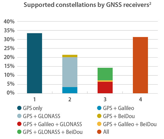
One remark in particular caught my eye as I read the press release précis of the European GNSS Agency’s 2018 GNSS User Technology Report. In point, “Today only around 30 percent of receivers use GPS only.”
“What?!?” methought. Incredulously, I downloaded the 92-page document, so easily done at www.gsa.europa.eu, and scrutinized it closely. Surely the GPS-only installed base out there is wider, vaster and deeper (it’s certainly older!) than could have been overtaken already by the wave of multi-constellation devices.
Yes, they are clearly the future. But is the past already gone? That golden age when GPS was all that anyone lived, positioned and navigated by — vanished into the mist?
Only earlier this very year was I upgraded from an iPhone 3 to an 8, with Galileo onboard for the first time. “Hip, but by the skin of my teeth,” I breathed.
Chart: GSA report
In the fine print on page 20 of the report lay clarification for my consternation. “For the analysis, each device is weighted equally, regardless of whether it is a chipset or receiver and no matter what its sales volume is. The results should therefore be interpreted as the split of constellation support in manufacturers’ offerings, rather than what is in use by end users.”
Of the roughly 500 chipsets and modules tallied by the GSA, 30 percent of those models are GPS-only. That’s a number of quite a different color. See the chart for fuller information.
Better minds than this can take a stab at how many devices in the hands end users on this day are still GPS-only. I’d put it above 50 percent.
The writing’s on the wall for the GPS-only artifact, but a good many of those veterans are still out there, working hard in the marketplace. Their reign as the majority may be limited, especially with the rising global tide of multi-constellation smartphones, but let’s honor them one last time before consigning them to the museum.
The GSA’s report, by the way, is a remarkably good and valuable read. No one can know it all, but this slim volume packs a remarkable and essential density of key facts, trends, issues, markets and more.
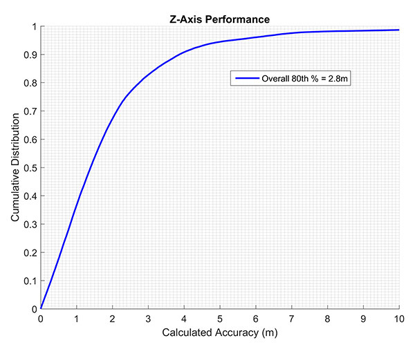
The company states that by using actual test call data to emulate active sensor compensation, its solution improved from 4.8- to 2.8-meter accuracy at the 80th percentile, which exceeds the commonly accepted definition of floor-level accuracy of under 3 meters.
The testing focus was to evaluate barometric-based solutions in advance of the Federal Communications Commission (FCC) establishing a vertical location accuracy metric for compliance by wireless carriers in the Top 50 markets, beginning in 2021.
Polaris Wireless was one of two technology vendors selected to participate and was the only solution tested in all buildings in all three cities: 48 buildings, 312 test locations and 55,592 test calls. The Polaris Wireless test included the widest variety of device and barometric sensor manufacturers.
Polaris Wireless achieved an official Stage Z vertical accuracy of 4.8 meters, 80th percentile, with a minimal one-time compensation of the barometric sensor outside of the test cities. However, this one-time compensation did not present a true test of Polaris Wireless vertical location accuracy.
Barometric sensor compensation is arguably the leading source of error in vertical location determination. During the test, Polaris Wireless did not enable active, in-market compensation of the baro sensor and instead relied solely on just a few test calls outside of the test market.
Polaris Wireless vertical accuracy from CTIA test data. (Chart: Polaris Wireless)
After learning that the other vendor included active, in-market compensation, Polaris Wireless submitted a comparable set of results using the same methodology to the CTIA for consideration in the report. This data was drawn exclusively from actual test calls, in the period before final results were published, to emulate the original performance as if active compensation had been activated.
These are referred to as “limited active compensation” results because sensor bias estimates were updated monthly instead of in real time. The figure shows the increase in Polaris accuracy when allowing for this active compensation.
Polaris Wireless says it continues to improve on its three-dimensional accuracy for both public safety and commercial applications, and is exploring additional forums for independent performance evaluation.
In a 50-page report to the U.S. Senate Armed Services Committee, the government’s General Accounting Office (GAO) finds that U.S. weapons systems are, almost across the board, highly vulnerable to cyber-attack. Furthermore, the Department of Defense (DoD) has gotten off to “a late start” in prioritizing cybersecurity, and has only “a nascent understanding” of how to develop more protected weapons systems. The October 2018 report, “Weapons Systems Cybersecurity,” is subtitled “DoD Just Beginning to Grapple with Scale of Vulnerabilities.”
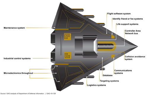
[Image above: Figure 2 from the GAO report: Embedded Software and Information Technology Systems Are Pervasive in Weapon Systems, represented via Fictitious Weapon System for Classification Reasons). Source: GAO analysis of Department of Defense information, GAO-19-128.]
GPS can figure to be among these threatened systems, and GPS guidance aboard many munitions and almost all platforms vastly expands the danger. The satnav system is not mentioned by name in the report (“To present information in an unclassified format, we do not disclose details regarding weapon system vulnerabilities, which program offices we interviewed, or which cybersecurity assessments we reviewed.”), and the word navigation surfaces only once, but it’s an alarming appearance:
“Weapon systems are dependent on external systems, such as positioning and navigation systems and command and control systems in order to carry out their missions—and their missions can be compromised by attacks on those other systems. A successful attack on one of the systems the weapon depends on can potentially limit the weapon’s effectiveness, prevent it from achieving its mission, or even cause physical damage and loss of life.”
The latter scenario could occur if a GPS-guided armament were hacked and rerouted to a civilian target, for example.
The GAO states that it warned as far back as 2015, and in repeated instances since that date, that federal and contractor systems face an evolving array of cyber-based threats, including criminals, hackers, adversarial nations, and terrorists. “Threats can range from relatively unskilled “script kiddies” who only use existing computer scripts or code to hack into computers, to well-resourced and highly skilled advanced threats who not only have sophisticated hacking skills, but also normally gather detailed knowledge of the systems they attack.”
Networks, Computers Increase Vulnerabilty
The increasingly computerized and networked nature of the U.S. military’s weapons contributes to their vulnerability. As weapon systems become more software- and IT-dependent and more networked, they actually become more vulnerable to cyber-invasion. Networks can be used as a pathway from one accessed weapon to attack other systems.
“Nevertheless,” the report adds, “until recently, DOD did not prioritize cybersecurity in weapon systems acquisitions. . . . DOD is in the early stage of trying to understand how to apply cybersecurity to weapon systems.”
As the GPS constellation — the satellites themselves as well as the ground control system — become more software-reliant, including the ability to modify signals by remote software command, this has to be a growing concern for the U.S. Air Force. Difficulties with cyber-proofing the next-generation ground control system, OCX, have been suspected as a leading cause of extended delivery delay in that program.
DoD officials reportedly confided that it will take time — and possibly some missteps — to learn what does and does not work in combatting cyber-attacks on weapon systems.
Separately, a UK defense expert consultant stated that Russia had “stolen a march on using cyber-capabilities at a tactical level on the battlefield.” As reported last year in GPS World, Black Sea spoofing incidents aroused suspicion that Russia was testing a new counter-combat technique.
Another spoofing expert said at the time, “It’s long been assumed that Russia, China and other nations (including the U.S.) have the technology to carry out a spoofing attack. What’s surprising is Russia’s willingness to use it openly and somewhat indiscriminately. It does fit nicely into what has been called Russian disinformation technology.”
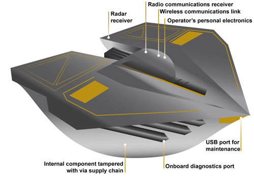
Figure 3 from the GAO report: Weapons Include Numerous Interfaces That Can Be Used as Pathways to Access the System (Represented via Fictitious Weapon System for Classification Reasons) Source: GAO analysis of Department of Defense information, GAO-19-128.
The amount of software embedded in weapon systems and subsystems has increased exponentially, expanding the respective weapons’ vulnerable surfaces. According to the military’s Director of Operational Test and Evaluation, “any exchange of information is a potential access point for an adversary. Even “air gapped” systems that do not directly connect to the Internet for security reasons could potentially be accessed by other means, such as USB devices and compact discs. Weapon systems have a wide variety of interfaces, some of which are not obvious, that could be used as pathways for adversaries to access the systems, as is shown in Figure 3.”
If attackers can access one of those systems, they may be able to reach any of the others through connecting networks.
Figure 4 from the GAO report: Weapon Systems Are Connected to Networks That May Connect to Many Other Systems (Notional Depiction for Classification Reasons)
Further, the DOT&E found that some networks were not survivable — that is, able to maintain critical capabilities under applicable threat — in a cyber-contested environment. The Defense Science Board concluded in 2013 that “the adversary is in our networks.”
The GAO adds that it and other organizations have been sounding off about such threats since the early 1990s — around the time that GPS itself became operational.
Tests of major military programs conducted between 2012 and 2017 revealed mission-critical cyber vulnerabilities that adversaries could compromise. “Test teams were able to gain unauthorized access and take full or partial control of these weapon systems in a short amount of time using relatively simple tools and techniques. . . . Once they gained initial access, test teams were often able to move throughout a system, escalating their privileges until they had taken full or partial control of a system.”
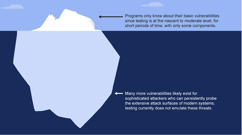
Figure 5: Vulnerabilities that the Department of Defense Is Aware of Likely Represent a Small Amount of Actual Vulnerabilities Due to Limitations in Cybersecurity Testing. Source: GAO analysis of Department of Defense information, GAO-19-128.
Beginning Steps
The Department of Defense is “still learning” how to address weapon system security and “still determining” what steps it may take. Implementation, once identified, will surely occupy an extended period. Complicating the picture, if DOD is able to make its newer systems more secure, yet connects them to older, vulnerable systems, the newer systems come into jeopardy.
Pass the Hash
A report appendix lists several different types of attacks with such pictorial names as: Man-in-the middle, Pass-the-hash, War driving, and Zero day exploit.
Respectively, these types of attacks connote:
• An eavesdropping attack in which the attacker intercepts to read or modify data communications to masquerade as one or more of the entities involved.
• Capturing an encrypted version of a username and password in order to authenticate to a server or service. The attacker does not have to decrypt the username and password (i.e., they do not actually know what they are), yet can still use them to log in to a system.
• Driving through cities and neighborhoods with a wireless-equipped computer — sometimes with a powerful antenna — searching for wireless networks potentially to exploit.
• Taking advantage of a security vulnerability previously unknown to the general public. In many cases, the exploit code is written by the same person who discovered the vulnerability. By writing an exploit for the previously unknown vulnerability, the attacker creates a potent threat since the compressed timeframe between public discoveries of both makes it difficult to defend against.
The UAV inspection industry continues to grow, as evidenced by these photos of actual end-user application. Unmanned systems follow precise flight paths to gather the data needed for inspection missions in the fields of insurance (home roof inspection), mining, construction and the pulp paper industry.
A free webinar on Thursday, Oct. 25 will show more of these applications and cover the requirements and challenges for positioning technology in commercial applications in urban and remote areas, including those generated by concerns about interference and spoofing.
Latest trends and challenges for drone-based aerial intelligence platforms for insurance and roofing applications
GNSS technology requirements for safe UAV BVLOS operations and a view of the regulatory frameworks
Importance of UAS traffic management systems (UTM)
Use cases in linear infrastructure inspection (railways, roads, power lines and others)
Challenges for GNSS systems in autonomous aerial vehicles and growing concerns about safety
Robustness of multi-GNSS receivers to jamming and spoofing
Latest innovation in GNSS technology concerning inspection applications and real-time accuracy/reliability
Earthworks contractors use this drone technology to perform detailed topographic surveys of project sites throughout all phases of construction. The new survey tool is reducing costs and time, allowing earthworks contractors to increase their profitability and ensure project success. (Photo: Paul Ross/Kespry)
In addition to a tailored application for roof inspections, targeted at insurance companies, UAV manufacturer Kespry provides a complete solution for construction and engineering companies to manage proposed and active earthwork operations. Without using multiple, cumbersome ground control points, survey-grade field data can be collected for an entire site in as little as 30 minutes.
In the webinar, attendees will learn how drone technology is being used to:
Validate proposed earthwork – reduce rework and extra earthmoving costs before the job begins
Safely measure earthwork activity – ensure subcontractor work and delivered material are constantly measured
Further application examples in construction projects will show how drones are providing construction companies with a new method for accurate survey work throughout their entire worksite that can:
Reduce up to 20 percent of total project costs by eliminating rework through regular cut and fill analysis of drone data
Eliminate up to 10 percent of earth moving costs through more accurate volumetric analysis
Perform more frequent surveys in-house with drones, reducing traditional survey equipment and service costs.
Kespry provides a complete solution for construction and engineering companies to better manage proposed and active earthwork operations. Without using multiple, cumbersome ground control points, survey-grade field data can be collected for an entire site in as little as 30 minutes. (Photo: Nathan Stump/Kespry)
In the first example show above, insurance claims for roof damage, the fully-autonomous system improves safety, reduces loss adjustment expenses, and delivers more accurate risk assessments, while reducing overall costs. For commercial property, the UAV solution helps prevent losses and informs underwriting decisions with high-resolution aerial and thermal imagery to identify exposures. Accurate, unbiased reports are easily prepared and shared with all parties. Mobile tools are provided to review inspection quality imagery within minutes of flight; artificial intelligence (AI) technology generates fully-dimensioned wireframes and 3D roof models
Drones for the pulp and paper industry
The drone and analytics platform enables companies to improve profitability through quick, cost-effective, and accurate surveying of chip and roundwood sites.
UAV applications in pulp and paper industry will be demo’d in the Oct 25 webinar (Photo: Jason Nichols/Kespry)
Kespry enables production plant and production managers to analyze stockpile inventories, better manage supply chain activity, and improve site operations — maximizing profitability across production and supply chain operations.
The company also supplies a drone-based AI platform for the aggregates and mining industry supplies accurate inventory management and mine planning. It will be demonstrated in the free October 25 webinar.
An Air Force professor was honored for years of work exploring every PNT technology imaginable in conjunction with GPS; Rockwell Collins launched a new MicroSTRIKE multi-GNSS chip for military and professional applications, available globally on a non-ITAR basis; and Spirent Federal previewed its SimMNSA, a new M-code simulation option delivering to authorized customers by the end of the year.
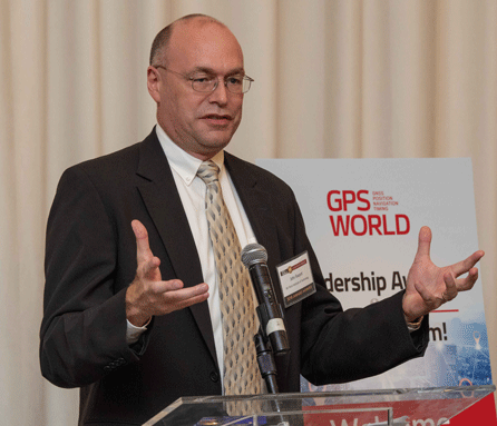
John Raquet, AFIT, accepts 2018 Leadership Award for Services from Justin Eldredge, Spirent Federal. (Photo: Melanie Beus)
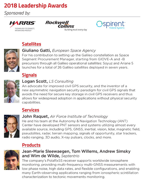
John Raquet, a professor in the Department of Electrical and Computer Engineering at the Air Force Institute of Technology, received the 2018 Leadership Award for Services. Raquet was recognized for work he and his team at the Autonomy & Navigation Technology (ANT) Center developed on PNT sensors and systems utilizing almost every available source, including GPS, GNSS, inertial, vision, lidar, magnetic field, pseudolites, radar, terrain mapping, signals of opportunity, star trackers, radio ranging, 3D audio, X-ray pulsars, clocks, and more.
Raquet has co-authored many defense-oriented technical papers over the past three decades. See the list at the end of this article for some of the most recent ones.
Justin Eldredge from Spirent Federal introduced Raquet and bestowed the award, after updating the audience on Spirent’s most recent advance: “This year we maintain our position of being first to market with new signals, with the launch of SimMNSA. We’re currently in the final test phase of this new M-code option and it will delivering to several authorized customers by the end of the year. If M-code signals aren’t in the spectrum of testing for you, we offer products that simulate all other GNSS signals, plus a variety of other sensors.”
SimMNSA was demo’d at the Spirent Federal Systems booth at the neighboring ION GNSS+ conference. A video presentation of SimMNSA (for Modernized Navstar Security Algorithm) is available here. Spirent’s new software will support M-code using MNSA. M-code is an updated GPS military signal that is being rolled out as part of the modernization of the current GPS constellation. Until now, AES and SDS have been the only methods authorized to be used within a GNSS simulator to produce M-code. As the long-awaited MNSA M-code signals become available, Spirent Federal Systems will make this capability available to authorized users on the GSS9000 series simulator.
ANT
After receiving the 2018 Leadership Award, Raquet spoke about his work at theAutonomy & Navigation Technology Center. “Sometimes I called the ANT the Crazy Idea Factory. We’ve tried lots and lots of things. I think I have the best job in the world, because I get to experiment with many, many things, and work with amazing people.”
John Raquet, U.S. Air Force Institute of Technology (Photo: Melanie Beus)
“This is not the kind of community where you build something once and you’re done, you put it away. This is a growing worldwide enterprise that takes new talent to come in and fill the spots that many of the people in this room have occupied. I’m privileged to see some of the students that we’ve worked with to then go on and fill some of the gaps, really do some amazing things.”
MicroSTRIKE, a non-ITAR GPS chip
Two awards prior to Raquet’s Services award, Phil Froom from Rockwell Collins, UK, spoke about an innovative venture from Rockwell and partners QinetiQ UK as he bestowed the Satellites award.
“For many years most of you here this evening will have known Rockwell Collins as a reliable partner in the delivery of Secure (encrypted) GPS receiver, and indeed, we are still the largest producer of encrypted military GPS solutions in the world. Our partners QinetiQ also have great expertise in the design and delivery of high assurance low SWAP GPS receivers, bringing together many years of expertise of our two companies in this new venture.
Phil Froom, business development lead for Rockwell Collins, Europe, Middle East and Asia (Photo: Melanie Beus)
“However, over the past few years we have seen our military and professional (government) users looking to greater flexibility in their use of GNSS, as new capabilities and constellations come on line. But with that flexibility, a retention of assurance and where possible, mitigation of threats. For this reason, last May, Rockwell Collins and QinetiQ signed an Alliance Agreement in London, to produce a new family of high-assurance, multi-constellation GNSS receivers for professional and military use.
“This new family of receivers is aimed to be complementary to the current encrypted family of Rockwell Collins receivers in service across the globe, but allow the customer to select his level of capability and protection based upon his operational, political or even financial needs. The new “MICRO” family of GNSS receivers will offer a multi-constellation open service (MCOS) GNSS capability, which will initially provide two receivers; the first, to be known as the Q40-MicroPNT, will address dismounted low dynamics requirements, and the second, the Q40-MicroSTRIKE, will be a gun hard, high dynamics receiver.
“You will note I said they are MCOS receivers. Therefore, they will not include an encryption device, will be Non-ITAR and will actually be produced in Europe, under the control of Rockwell Collins UK. QinetiQ are today working on the Q40 ASIC and, once available, this will be incorporated into these first two Micro Family receivers.
“These receivers will be of a common format to our existing and highly successful SAASM based MicroGRAM receivers and will offer users and OEMs the ability to select an MCOS receiver, or a SAASM (or ultimately M-Code) receiver, of a common form – factor, to meet their mission or platform needs. Thus allowing OEMs to reduce costs in integrating different form-factors, and to allow users to hold common hardware, but mounting mission specific receivers.
“We are of course extremely excited about this Alliance with QinetiQ and equally by the prospect of what it will bring to our existing and future users as we all move forward into this new era of GNSS capability.”
Check out videos from the event below. Click on the icon in the top left hand corner to choose which video you’d like to watch.
Recent technical papers co-authored by John Raquet.
• “Magnetic field navigation in an indoor environment,” Ubiquitous Positioning Indoor Navigation and Location Based Service, (Aiding an inertial navigation system when GNSS signals are not available, by taking advantage of the uniqueness of magnetic field variations);
• “Comparison of two image and inertial sensor fusion techniques for navigation in unmapped environments,” IEEE Transactions on Aerospace and Electronic Systems, (navigation of miniature aerial vehicles (MAVs) couplimng information from an IMU with visual information from an electro-optical camera);
• “Real-time UWB-OFDM radar-based navigation in unknown terrain,” IEEE Transactions on Aerospace and Electronic Systems (a signal processing algorithm and simulation study for aerial navigation with an ultrawideband orthogonal frequency division multiplexed (UWB-OFDM) radar in GPS-denied environments;
• “Navigation in GPS denied environments: Feature-aided inertial systems,” Air Force Research Lab, Eglin AFB FL Munitions Directorate (latest alt-nav trends for navigating in difficult urban, indoor, and underground environments where typical GPS receivers do not function;
• “Coded aperture aided navigation and geolocation systems,” US Patent office #8577539 (A micro air vehicle having a navigation system with a single camera to determine position and attitude of the vehicle using changes the direction to the observed features);
• “Multisensor navigation systems: A remedy for GNSS vulnerabilities?” Proceedings of the IEEE (A multisensor navigation approach to GNSS-challenged environments using inertial measurement units (IMUs), barometers, magnetometers, odometers, and digital compasses);
• “Large scale image aided navigation,” IEEE Transactions on Aerospace and Electronic Systems (images from an airborne camera match features against a reference image to compute global position);
• and many more.
At the GPS World Leadership Dinner and Awards Ceremony in Miami on Sept. 27, 120 VIPs from the international GNSS/PNT community gathered to honor recent significant achievements in four fields: Satellites, Signals, Services and Products.
The honorees, so voted by a panel of their peers, appear below. Also, see our article here.
Their remarks upon receiving the awards will appear in the December issue, along with Future Visions for 2019 by the executive officers of GPS, GLONASS, Galileo and BeiDou.
Rounding out the evening after speeches, dinner and good conversation among good friends, old and new, was the Smart City Jam! We attempted to replicate, on the carpet of the 14th-floor banquet room, an obstructed urban environment, replete with malicious jammers. And we challenged all comers to “autonomously” navigate to a goal in this hostile environment with remote-controlled rock-crawlers. Details on this as well coming up in December.