Honeywell has unveiled its resilient embedded GPS/inertial navigation system (EGI), designed to address the evolving challenges of modern warfare and meet U.S. government mandates for greater power competition. This navigation system integrates GPS and inertial navigation technologies to deliver precise position, velocity and timing information for various applications.
Expanding on Honeywell’s H-764 and FALCN, the EGI is specifically designed to fulfill military needs in areas where GPS jamming and spoofing are prominent. The system includes M-code capability, an atomic clock and open architecture compliance, allowing crucial mission flexibility with alternative positioning, navigation and timing (PNT) forms.
It allows for the seamless integration of various alternative PNT sources, including vision navigation, celestial navigation and magnetic navigation for continuous and accurate navigation even in the face of GPS threats.
Honeywell plans to make engineering units of this EGI available in early 2026, with certifiable units following shortly after. The company said this timeline allows for thorough testing and refinement, ensuring the system meets the reliability and performance required for critical military applications.
Unicore has partnered with ArduSimple to integrate Unicore’s tripleband GNSS real time kinematic (RTK) receivers into ArduSimple’s evaluation boards.
Photo: Unicore
The UM980, UM981 and UM982 RTK modules are integrated into the ArduSimple simpleRTK3B series to accelerate high-precision GNSS integration. Supporting Galileo High Accuracy Service (HAS) and fast update rate (50Hz), these devices are suitable for applications that require reliable and precise navigation.
simpleRTK3B Budget (UM980): The most affordable step into triple-band precision.
simpleRTK3B Fusion (UM981): Ideal for projects that need GNSS and inertial measurement unit (IMU) sensor fusion or tilt compensation.
simpleRTK3B Compass (UM982): Designed for setups requiring dual antennas to determine the heading on moving platforms.
ArduSimple has also integrated Unicore UM980, UM981 or UM982 modules into the simpleRTK3B Micro Unicore, part of the most compact Micro-format lineup. It is designed for simple PCB integration, which can significantly speed up the development process and the time to market for new products.
On Sept. 10, the GeoGov 2024 Summit hosted a panel discussion between NGS and other federal and industry leaders on the modernized National Spatial Reference System (NSRS). High-level management and leadership officials attended the conference, which was a great place to network and collaborate with federal agencies.
Panel session on NSRS modernization.
As you can see from the announcement, the panel members represented a wide range of users of the NSRS. They were asked to address the following four topics based on their perspective of the rollout of the new, modernized National Spatial Reference System:
Benefits of Modernization
Challenges of Modernization
Opportunities Provided by Modernization
Next Steps in Collaboration
As one would expect, there was a wide range of responses based on the individual panel’s perspective of what the new, modernized NSRS means to their products, services and constituents. Even though there were many responses based on the individual panel’s perspective, there were many common ideas. This newsletter will highlight some of the bullet points presented by the panel members during their presentations. I attempted to combine similar statements for every topic under a common theme.
Summary of Benefits of Modernization
A unified four-dimensional system will finally provide a sustainable spatial reference frame for managing the state’s geospatial resources.
Combining of horizontal and vertical datums in one system
Improved spatial data quality – both horizontal and vertical
Simplification in which vertical reference frame and GEOID to use in local areas with the new NAPGD2022
Improved accuracy of the horizontal and vertical coordinates
A common “language” or framework for spatial data
Greater consistency in non-CONUS areas like AK, Hawaii, PR, and USVI
We can write NSRS requirements into any task order for acquisition
Additional uniformity for surveying practitioners
Better spatial data sustainability
The unification of marine and terrestrial geoids is important for managing our valuable coastal resources (all heights should be geoid based)
Closer integration with tidal datum information
Improved height information will enable us to provide the most accurate data possible
Direct relationship to ITRF2020 offers the ability to deliver the intra-frame deformation model through real-time networks
The introduction of reference epochs on NGS geodetic survey benchmarks and the time-dependency of the datums
The ability to more easily link the data to ITRF
Expansion of low distortion projection (LDP) systems
Lack of metadata within historical information to adapt to the new datum
Ensuring data fidelity, now and always! (METADATA)
People and processes; not technology
Users with lack of understanding of a time-dependent datum
Surveyor making time to learn about new datum
Understanding the impact of the new system to your products and services
How do we convince them to effectively transition all their historic data to the latest reference system?
Confusion among end users in understanding geodetic terminology and time-dependent way of perceiving coordinates
Adequate understanding by all stakeholders
Degrading coordinates and heights can impact reliability over project lifespans (NGS may not be able to respond to natural changes and emergencies)
Maintaining an accurate deformation model for use by many geospatial users in their specific workflows
Updating specifications on ground surveys for lidar and ortho projects that are processed through OPUS (How do we better educate our team and partners on what can be considered accurate for those observations)
Updating of existing surveying equipment to include new datum
Potential confusion in reported accuracy as it relates to changes in epoch vs. actual error of the equipment (ground-based or aerial/satellite) and the approach used to measure the feature
Transformations to new datums may incur costs if partners do not want to “modernize” data (Potential of needing two copies of data delivered)
Will need to develop policy deciding if we “modernize” all our older/existing data, or just start with the new NSRS at a certain point in time
Need operational software that reprojects/transforms data – especially large, bulk features (e.g., lidar point clouds)
Combining legacy data with modern data can lead to loss of data fidelity and often difficult to recognize changes to the data
Many challenges were mentioned, but I found it interesting that panel members highlighted issues with the user’s lack of understanding of the new system’s impact on their products and services. It is about people, not the processes or new technology. This was not surprising to me because this was an issue when NGS implemented the North American Vertical Datum of 1988 (NAVD 88). I know this firsthand because I was the NAVD 88 Program Manager while working for NGS. Surveyors and mappers are used to dealing with new technology and datum changes. Still, management and leadership have different issues that need to be addressed for new technology and datum changes. Hopefully, the management and leadership that attended the GeoGov 2024 Summit will start identifying how their products and services will be affected by the new NSRS and developing implementation plans.
Summary of Opportunities Provided by Modernization
Increased collaboration between private entitles and public agencies
Providing better service
Reducing cost
Improving safety and welfare
Expanding innovation
More reliable data for monitoring trends in infrastructure
Providing efficient and cost-effective tools and processes for users to update their mapping products to the new reference system
More accurate data collection/dissemination to benefit the public
More uniformity of data collection between surveyors
Improved reliability of advanced positioning built on the new NSRS
Improved heights for flood mapping products for forecasting, infrastructure planning and design, and accessibility using GNSS
Facilitates integration of tidal datum, critical to coastal science and industry
Allows for unification with SAR imagery and satellite altimetry, improving earth observations and mapping products
Improved Change Detection estimations
Better metadata descriptions for understanding times of collections
Increased vertical data for monitoring existing conditions
More accurate representation of the Earth’s surface over time as it lates to coastal change (sea level rise, flood modeling, coastal erosion, etc.)
Compensating for workforce attrition
As in any new paradigm, there are opportunities for increased collaboration between users and the development of new products and services. The panel members highlighted opportunities to provide better service to customers, develop more efficient and cost-effective tools for users and improve coastal change detection models.
Next Steps in Collaboration
Cross promotion of new datums within likeminded professions
Recruitment into geospatial professions
Increased awareness of the importance of the geospatial professions
New or expanded collaborations across professions
Leveraging non-federal resources and their active user communities spanning surveying, geophysical science, regional governmental agencies, industry, and academics
Working together to convince state/local agencies to adopt the new datums
Working with geospatial societies (NSPS, AAGS, ASPRS, URISA,etc.) for impact awareness
Working together to identify the new NSRS impact on your products and services
Guidance from professional organizations and societies
Implementation of tools and processes for datum conversion for large remotely-sense datasets for more effective data analysis for reporting climate change
Under the next steps in the collaboration section, promoting the new reference frames with other geospatial professionals was mentioned as an opportunity to leverage resources and expand the understanding of the new NSRS’s effect on users’ products and services. That is, increasing the number and types of stakeholders and constituents affected by the new reference frames will increase awareness of the new NSRS.
Joint Actions to Promote a Smooth Transition
Promoting awareness to non-technical leadership within AEC industries
Provide examples of the potential for a datum upgrade (smart cities, digital twins, autonomous transportation.)Educate allied professionals (e.g. engineers, contractors, operators.)Develop unified messaging for practitioners (e.g., best practices/standards.)
Focus on the education component and benefits of the new datum.
Act now to develop a specific plan and resource allocation to implement the new reference frame
Helping develop appropriate standard metadata/STAC templates and information
Provide open-source tools to the private sector to enable datum conversion and an open discussion forum.
For a smooth transition of the new NSRS, it is important to identify actions required for implementation. Promoting awareness to leadership is critical for the implementation of any new system. In the case of the new NSRS, it is essential for federal agencies to get engaged in the process now. I was pleased to hear that panel members mentioned that it is vital for federal agency engagement through the Federal Geographic Data Committee (FGDC) and the Federal Geodetic Control Subcommittee (FGCS) to be compliant with the Geospatial Data Act of 2018 (GDA 2018). These federal agencies must develop plans and allocate resources to implement the new NSRS.
As previously stated, high-level management and leadership attend the GeoGov 2024 Summit conference. It is a great place for networking and collaborating within federal agencies and for better understanding the issues associated with implementing the new, modernized NSRS.
Technology and tools are essential for the development of the new, modernized NSRS. That said, understanding how the use of technology and tools meet the users’ requirements is necessary for implementation.
Some users trust NGS models and tools without following the appropriate procedures. Standard operating procedures are used in a workflow to help meet users’ project requirements. In my opinion, understanding the impact of the new system on a specific product and service is the most important part of implementing the new NSRS. Documenting the workflow used to create a product and service and then using this information to develop standard operating procedures that use the appropriate tools and procedures will help implement the new, modernized NSRS.
In less than a year, NGS will be finalizing the new terrestrial reference frames and geopotential datum. Time really is running out and users need to obtain a working knowledge of the new, modernized NSRS.
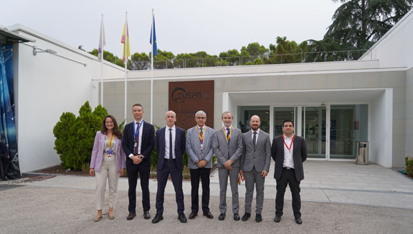
The European Union Agency for the Space Programme (EUSPA) has awarded GMV a six-year framework contract to upgrade the European GNSS Service Centre (E-GSC) infrastructure. The contract is valued at €35 million ($39 million).
The E-GSC is critical to the European Union satellite navigation program’s infrastructure. Its primary mission is to provide a unified interface for users of the Galileo and EGNOS systems, offer supporting services, and contribute to delivering new Galileo services. The E-GSC’s various functions include distributing data from the European Union navigation satellite services to the user community and supporting the growth of the global Galileo applications market.
Originally designed to be part of the European GNSS infrastructure and to provide a unified interface between the Galileo system and its users, the E-GSC has expanded its role over the years to become a key component in delivering services enabled by the European Union Space Programme.
The new framework contract aims to advance the E-GSC’s capabilities, enabling it to take on increased responsibilities. This includes creating new services for users, enhancing their experience, integrating service delivery aspects of Galileo and EGNOS, and supporting the development of additional services.
GMV is leading a consortium that features Indra as the main industrial partner, along with prominent companies such as Spaceopal, ESSP, Alten, the Universitat Politècnica de Catalunya (UPC) and the Universidad Autónoma de Barcelona (UAB).
Under the supervision of EUSPA as Contracting Authority, GMV will oversee project management and IT infrastructure development through all stages, including definition, implementation, validation and integration into the Galileo ground segment. GMV will also develop the software components necessary for delivering new data and signal authentication services for Galileo satellites.
SPH Engineering and Radar Systems, Inc. have developed the Zond Aero 500 NG, a versatile ground penetrating radar (GPR) system designed for both terrestrial and drone-mounted surveys. This dual-purpose GPR is suitable for various applications, including utility scanning, sinkhole detection, glaciology and geological studies.
The Zond Aero 500 NG features dual-mode operation, allowing users to conduct both ground-based and airborne surveys. This flexibility enhances the data collection methods available to operators. The system includes a center frequency of 500 MHz, an operating bandwidth of 200-900 MHz (-12 dB), a sampling rate of 25,600 samples per second and a scan rate of 50 scans per second. It can achieve depth penetration of up to 4 m in average soil conditions, making it effective for a range of subsurface investigations.
It is designed to deliver high-quality data through advanced electronics and real-time to enhance the signal-to-noise ratio significantly. This improvement enables the detection of finer details and deeper anomalies within the surveyed area. Additionally, the system is compatible with DJI Matrice 300/350 UAVs for airborne applications.
The system’s data is recorded in real time as radiolocation profiles (radargrams), which are stored for further processing and interpretation. The data is saved in the standard geophysical SEGY format (.sgy) with geotagging for each trace to offer accurate analysis and reporting.
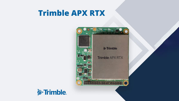
Trimble has introduced the APX RTX portfolio, a new line of direct georeferencing solutions designed for UAV mapping sensors. This system enables high-accuracy mapping across diverse environments, ideal for OEMs and UAV payload integrators.
At the core of the APX RTX portfolio is the Trimble CenterPoint RTX technology, which offers both real-time and post-mission direct georeferencing. This capability allows for centimeter-level accuracy without the need for base stations, making it compatible with various sensors, including cameras, lidar and hyperspectral mapping devices.
The system’s hardware features include a compact GNSS inertial unit that supports real-time positioning. Additionally, external inertial measurement unit (IMU) support is an option to enhance orientation accuracy. The portfolio also utilizes high-accuracy MEMs calibrated with Trimble Applanix SmartCal compensation technology to improve precision.
It is embedded with compact, survey-grade GNSS inertial hardware that delivers real-time positioning and highly accurate roll, pitch and heading measurements. It includes four variants for mapping at different flying heights and beyond visual line of sight (BVLOS), enabled through greater orientation accuracy.
The Trimble Applanix IN-Fusion+ multi-sensor aided inertial technology leverages Trimble ProPoint GNSS technology to offer consistent performance in various environments. The APX RTX portfolio offers the Trimble CenterPoint RTX Complete subscription to streamline workflows. This subscription combines real-time functionality with post-processing capabilities in POSPac UAV, eliminating the need for separate licenses or internet connections.
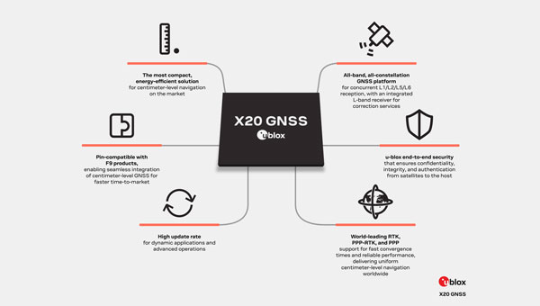
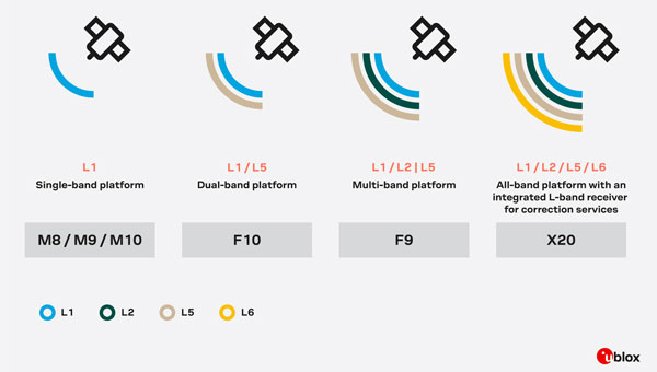
u-blox has introduced the X20, a new high-precision GNSS platform that builds upon its previous F9 platform. The X20 is designed to meet global demands for high-precision GNSS capabilities while accommodating future technologies and standards.
The X20 operates across all GNSS frequency bands (L1/L2/L5/L6) and includes an integrated L-band receiver. The L5 band operates at lower frequencies, which can improve signal robustness, while the L6 band is used for navigation and correction services to enhance positioning accuracy. This comprehensive coverage allows for high-precision positioning even in challenging signal environments.
The platform supports various correction services, including local base stations, real-time kinematics (RTK), network RTK, precise point positioning (PPP) corrections and PPP-RTK.
It is suitable for applications requiring centimeter-level positioning accuracy under challenging environments, such as port logistics, construction machine control, UAVs, autonomous ground robotics (e.g., lawnmowers) and time synchronization for critical infrastructure systems.
The X20 platform incorporates comprehensive security measures such as end-to-end security functions, system authentication via secure boot and firmware updates, message authentication and encryption with a built-in secure root of trust (RoT).
It supports Galileo OSNMA authentication and features advanced jamming and spoofing detection and mitigation. The X20 platform is designed to be software upgradeable, allowing users to adapt to future developments in GNSS technologies and standards.
The United Kingdom’s Ministry of Defence (MOD) is focusing its alternative positioning, navigation and timing (Alt PNT) project on deployable eLoran. This comes after industry days for Alt PNT in March and June 2024.
The announcement came in a Request for Information (RFI) on Sept. 20. It specifies that a contract will be let for the development of a deployable eLoran network. As part of that contract, the MOD also wants to develop:
A modelling capability, which will allow for theoretical analysis of capabilities and informing the concept of employment.
An assured capability within the Loran Data Channel
Information and demonstration of the resulting capability to stakeholders
UK PNT Policy Framework
Last year, the UK government announced a ten-point “policy framework” for advancing the nation’s PNT resilience. One of the ten points is:
“Develop a proposal for a resilient, terrestrial, and sovereign Enhanced Long-Range Navigation (eLORAN) system to provide backup position and navigation.”
Most have seen this as a provision for a fixed domestic system for use by critical infrastructure and applications. The UK already has an on-air single eLoran transmitter that provides a timing signal. An announcement about establishing two or more additional transmitters to provide PNT services for the British Isles and their adjacent waters has been anticipated.
The policy framework also includes:
“Develop a proposal for ‘MOD Time’ creating deeper resilience through a system of last resort and use NTC-provided timing to support MOD.” [NTC stands for National Timing Centre.]
It is not immediately clear how this RFI from the MOD fits these two provisions, if at all, or is entirely separate.
1970s Deployable Loran
Deployable Loran, or Loran-D was first developed for the U.S. Air Force in the 1970’s. An oral history recounts that a system was deployed early in the 70’s by the 6514th Test Squadron at the Utah Test and Training Range (UTTR), a component of Hill Air Force Base. It was built by Megapulse, employed a Hewlett Packard beam clock and 150 ft antennas, and was used for testing unmanned aircraft. There are also indications elsewhere that the Air Force used it for precision bombing.
Industry sources say that this earlier work provides a solid foundation for developing future deployable eLoran systems.
UK MOD Requirements
The RFI is fairly specific about the questions it wants answered. These requirements look nearly ready to be transformed into a Request for Proposal and contract language. They include:
The demonstrator system shall include a minimum of 3 transmitters to enable a suitable receiver to live demonstrate position and time determination from the system.
Across the coverage area, the system shall transmit a signal that allows receivers to achieve position and timing accuracy in line with the needs of defense platforms (which have not yet been specified).
The system shall be able to operate with and without GNSS access.
The system shall be able to operate both with and without access to eLoran signals from eLoran transmitters outside the deployable system’s group.
The system shall be capable of maintaining performance & accuracy for prolonged periods, including without access to eLoran and GNSS signals.
The system shall be able to be contained and transported in an ISO container.
The system shall be able to be assembled, initialized and disassembled by as small a team as possible.
Respondents must submit by the 18th of October to be considered.
“Seen & Heard” is a monthly feature of GPS World magazine, traveling the world to capture interesting and unusual news stories involving the GNSS/PNT industry.
The Northern Plains UAS Test Site (NPUASTS) has assisted the Grand Forks, North Dakota, Fire Department in obtaining a Tactical Beyond Visual Line of Sight waiver from the Federal Aviation Administration, allowing first responders to operate unmanned aircraft systems (UAS) beyond visual line of sight (BVLOS) in extreme emergencies. This capability can be used to assess large fires, conduct aerial searches and locate missing persons. The NPUASTS team trained 11 first responders in UAS operations and flight protocols.
Free Autonomous Shuttle Service Launches in Detroit
Photo: Detroit
A free autonomous shuttle program has launched in Detroit, Michigan. The four electric, wheelchair-accessible “Connect” shuttles will operate every 10 to 15 minutes during peak hours along a 10.8-mile route from Michigan Central to Bedrock’s 200 Walker Street on the East Jefferson Riverfront. Initially, the shuttles will be manually operated to allow for route adjustments and ensure smooth operation of autonomous features. Full autonomous driving is expected later this year.
Maui Recovers One Year After Deadly Wildfires
Photo: Maxar Technologies
New satellite images from Maxar Technologies reveal the extent of damage in Lahaina, Maui, nearly a year after the catastrophic wildfires on Aug. 8, 2023, which resulted in more than 3,900 properties being destroyed and 100 fatalities. Despite the devastation, the satellite image shows signs of recovery, with debris removal progressing and new temporary housing being constructed for displaced residents. The images show cleared lots and returning greenery.
Sea Lions on a Mission
Photo: Nathan Angelakis
Researchers have attached lightweight video cameras to sea lions to explore previously uncharted areas of the ocean off the south coast of Australia. The footage, combined with a machine learning model, produced detailed maps of the ocean floor, revealing the distribution of different habitats and species. This method allows scientists to access deep and remote habitats that are unreachable by traditional hydrographic surveys. The study, published in Frontiers in Marine Science, highlights the potential of using animal-borne cameras for marine exploration and conservation efforts.
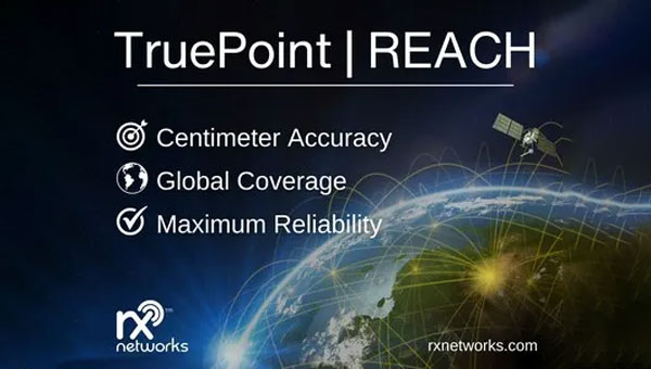
Rx Network has launched TruePoint | REACH, an advanced, hardware-agnostic, cloud-based correction service designed to deliver centimeter-level location accuracy worldwide for various professional applications.
TruePoint | REACH offers precise centimeter-level positioning to enhance GNSS receivers’ performance in applications such as precision agriculture, machine control, mining, marine operations, UAV, GIS and more. The service is compatible with leading commercial off-the-shelf receivers using the RTCM 3.3 SSR and the 3GPP LPP SSR format. The company said key hardware partnerships are in the planning stages and will be announced soon.
TruePoint | REACH eliminates the need for users to set up their own base stations. Users can achieve centimeter-level accuracy by connecting receivers to the cloud while leveraging Rx Networks’ comprehensive global coverage.
Its correction engine is built to provide centimeter-level accuracy worldwide and can achieve sub-3cm precision in under 10 minutes. This makes it suitable for applications that require moderate initialization times for high-precision services.
A test version of TruePoint | REACH is available for those interested in assessing its capabilities. Users can sign up for a complimentary 30-day trial license through the Rx Networks website.
The European Union Agency for the Space Programme (EUSPA) has awarded a contract to a consortium led by GMV to design, develop and deploy the communications hub for the Governmental Satellite Communications (GOVSATCOM) programme. This contract, valued at up to €107 million ($119 million), is a critical component of the European Union (EU) satellite communications initiative.
GOVSATCOM is one of the five main components of the EU Space Programme, alongside Copernicus, Galileo, EGNOS and Space Situational Awareness. Its primary objective is to provide secure and cost-efficient satellite communication services to authorized governmental users in EU Member States.
The program aims to support various scenarios, including crisis management, border and maritime surveillance, critical infrastructure management and security operations in polar regions.
The communications hub is a critical element of the GOVSATCOM architecture. Its main functions include:
Ensuring optimal delivery of satellite communication services
Meeting the demand for operational services from EU Member State users
Planning for predefined medium-term communication needs
Handling dynamic and urgent requests from unforeseen scenarios
Operating under strict security and resilience requirements
The hub will manage satellite communication resources from EU Member States and services provided by the EU’s future multi-orbital secure communications constellation, IRIS2.
The consortium led by GMV includes Indra and Hisdesat. The contract was awarded following a competitive bidding process involving pre-selection consortia and execution of parallel contracts for preliminary design and capability demonstrations.
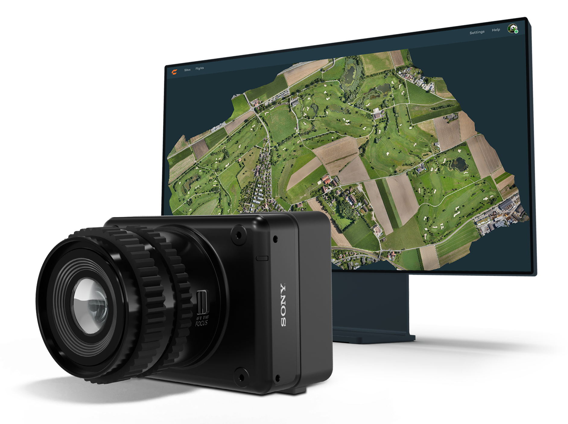
Wingtra has launched the MAP61 mapping sensor, designed to assist professionals in generating larger mapping outputs more efficiently. This ultra-high-resolution sensor offers detailed 3D data in a single pass, providing valuable analytics for vertical assets.
The MAP61 can cover up to 460 hectares (1,140 acres) in a single flight, reducing fieldwork time and enhancing productivity. According to Julian Surber, product manager at Wingtra, the MAP61 can decrease fieldwork time from one hour to approximately 35 minutes while doubling processing speed. This efficiency is beneficial for projects requiring both 2D and 3D data.
MAP61 features oblique sensor configuration, which can facilitate detailed mapping of long structures such as highways without interrupting traffic flow. This design reduces the need for cross-hatch flights, cutting field time in half for vertical resolution and accuracy, which is critical in industries such as construction.
The MAP61 is versatile and suitable for various applications including land management, urban planning, highway mapping and progress monitoring in open-pit mines. Its ability to operate efficiently in challenging environments — such as urban areas or open pit mines —makes it a valuable tool for professionals who need timely data.
The system can integrate seamlessly within an intuitive mapping workflow. Wingtra combines vertical take-off and landing (VTOL) capabilities with its software platform, WingtraCLOUD. This integration allows users to plan, capture and process data without switching between different software applications.