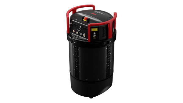
Leica Geosystems, part of Hexagon, has introduced the Leica TerrainMapper-3 airborne lidar sensor. It features new scan pattern reconfigurability to support a variety of applications and requirements in a single system.
The system offers three scan patterns, which allow users to customize the sensor’s performance to fit specific applications. Its circle scan patterns are designed to improve 3D modeling of urban areas or steep terrains. The ellipse scan patterns use data capture for more traditional mapping applications. Skew ellipse scan patterns are aimed at improving point density for infrastructures and corridor mapping applications.
The sensor has a high scan speed rate and a 60° adjustable field of view to maximize data collection with fewer flight lines. The TerrainMapper-3 is complemented by the Leica MFC150 4-band camera, which operates with the same 60° field of view coverage as the lidar for exact data consistency.
The device’s reduced beam divergence offers more accurate results, while its new multiple pulses in air (MPiA) handling is designed to deliver more consistent data acquisition, even in steep terrain.
The new system introduces possibilities for real-time full waveform recording at maximum pulse rate to open opportunities for advanced and automated point classification.
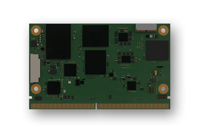
SECO, a global provider of end-to-end technological solutions for the digitalization of industrial products and processes, has released its first Smart Mobility Architecture (SMARC) System on Modules (SoMs) based on Qualcomm QCS6490 and Qualcomm QCS5430 application processors. These new SMARC modules are the first results of SECO’s strategic collaboration with Qualcomm Technologies, announced in September 2023. Both companies aim to help accelerate the development of innovative edge computing products for the industrial internet-of-things (IoT) world.
The SOM-SMARC-QCS6490 is designed to simplify the use of the Qualcomm QCS6490 processor. The chipset offers support for artificial intelligence (AI) and computing, robust performance at low power and expanded interfaces and peripherals catering to diverse industrial use cases.
The Qualcomm Adreno 643 GPU offers enhanced graphics performance and energy efficiency. It supports FHD+ at 120 fps resolution on primary and secondary displays up to 4k Ultra HD at 60Hz. The SOM-SMARC-QCS6490 supports Microsoft Windows 11 IoT Enterprise, Yocto Linux, and Android, with both commercial (0°C to +60°C) and industrial (-30°C to +85°C) temperature variants available.
The SOM-SMARC-QCS5430, powered by the Qualcomm QCS5430, is a mid-tier solution that slightly moderates CPU and GPU performance. This system-on-chip (SoC) combines enhanced connectivity, performance and edge AI-powered camera capabilities. It also provides scope for field software-based upgrades of the CPU and GPU by using the processor’s capabilities.
VIAVI Solutions will acquire Spirent Communications for $1.27 billion. According to VIAVI, the acquisition aims to boost its position as a premier provider for research labs, service providers, data centers and mission-critical infrastructures worldwide.
The merger aims to integrate VIAVI and Spirent’s complementary product portfolios and services and to offer a broad spectrum of solutions across various markets and applications.
This collaboration is expected to meet the demands of high-growth sectors such as cloud service providers, enterprise/IT networks, and emerging 5G and 6G technologies, as well as positioning, navigation and timing (PNT) verticals.
As a result of the acquisition, VIAVI aims to accelerate technology development and product innovation, particularly in areas such as artificial intelligence, machine learning, security, cloud-native architecture and automation. By using both companies’ joint engineering, research, and development expertise, VIAVI intends to foster innovation, enhance operational efficiency and generate substantial cost synergies.
The partnership is expected to yield annual run-rate cost synergies of up to $75 million within two years post-acquisition.
This acquisition aims to bolster VIAVI’s position as a global provider of test, assurance and security solutions. Moving forward, the focus will be on delivering high-performance, integrated solutions that ensure reliability, efficiency and security across critical network infrastructures and digital ecosystems, VIAVI said.
Vodafone Turkey has integrated Adtran’s Oscilloquartz optical cesium atomic clock technology into its national network. The integration aims to enhance the resilience of network synchronization against disruptions in GNSS signals, a crucial step as the company progresses towards the implementation of 5G services.
The deployment establishes a network-wide synchronization solution capable of maintaining precise timing, even during GNSS outages. This technology is essential for ensuring continuous, reliable connectivity across Vodafone Turkey’s services.
The core of the solution, the Oscilloquartz OSA 3350 ePRC+, uses optical pumping technology for frequency stability. This device, combined with Vodafone Turkey’s existing grandmaster clocks and the Oscilloquartz clock combiner, forms the ePRTC+ system.
The system is designed to achieve a 100-nanosecond accuracy level for a period extending to 45 days, which surpasses the ITU-T G.811.1 standards for network timing.
Vodafone Turkey will implement a system across five strategic sites to mitigate risks associated with GNSS signal loss that can impact network operations and service quality. This aims to enhance redundancy and ensure network stability under challenging conditions including natural disasters and electronic interference.
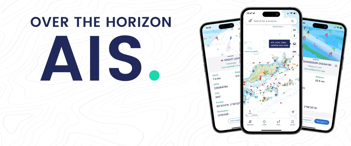
savvy navvy has released Over the Horizon (OHA) automatic identification systems (AIS) in its latest mobile application update. OHA uses a phone’s internet connection to stream other vessels’ locations in real-time directly to the app to improve safety on the water.
Traditional AIS received from the transceiver on the boat has a range of a few miles, whereas OHA is designed to show vessels further afield. While OHA does require an internet connection, users do not need additional hardware to see information on vessel movements.
“Not all boaters have AIS hardware on their boats,” said says Jelte Liebrand, founder and CEO of savvy navvy. “A recent study found that depending on the vessel type, 30% of boaters, and in some cases even as much as 75%, do not own AIS transceivers. But all these boaters could benefit from OHA AIS to be able to see what’s around them and stay safe.”
OHA AIS allows savvy navvy users to see vessels directly on the chart with small and large vessel crafts defined by different colors. Users can also check how crowded the anchorage might be — either from onboard or while planning routes at home.
The savvy navvy app highlights when no position has been received for more than 30 seconds, which marks the positional variance area around each vessel and allows users to be extra vigilant when navigating.
Available on Android, IOS, PC and Mac, the savvy navvy app can be used on multiple devices and is available in both free and “premium” options with enhanced access and functionalities.
The European Space Agency (ESA) and the European Commission’s Joint Research Centre (JRC) are collaborating to host the 15th edition of the International Summer School on Global Navigation Satellite Systems (GNSS).
The course is scheduled to take place in Novo Mesto, Slovenia, from July 15 to 26, 2024.
The summer school invites graduate students, Ph.D. candidates, postdoctoral researchers, engineers and academics from both the industry and agencies to attend. The wide range of attendees offers a dynamic environment conducive to learning and networking.
The deadline for registration is June 15. Those who register by April 15 will be offered reduced fees. Additionally, the ESA Education Office is offering up to four scholarships.
The comprehensive curriculum of the summer school encompasses all aspects of GNSS, starting from the fundamental principles of satellite navigation to recent advancements in positioning, navigation and timing services.
Participants will have the opportunity to learn from world-leading experts in the field, including ESA Director of Navigation, Javier Benedicto, former ESA Director General, Jean-Jacques Dordain and former ESA Director of Navigation, Paul Verhoef.
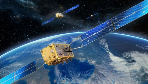
The European Union Agency for the Space Program (EUSPA) has published a technical document detailing the main characteristics of the new Galileo Emergency Warning Satellite Service (EWSS).
According to the document, Galileo satellites will transmit emergency warning messages directly to Galileo-enabled smartphones and other navigation devices. The satellites will offer information related to the hazard, such as type, severity, expected onset and duration, as well as the location of the affected area and instructions to follow. The alert content will be generated by national authorities and transmitted to Galileo for broadcast.
“With this new document, some of our key stakeholders can already start to work with this new service,” said Fiametta Diani, head of market, downstream and innovation at EUSPA. “Civil protection authorities in the member states can start to prepare for how they will manage the alert messages they will send via Galileo. The same goes for the receiver and chipset communities, who will have to process this message.”
In 2023, EUSPA began testing the EWSS in different locations in Europe. “We have run trials in Toulouse and in Germany, specifically with a simulated explosion,” Diani said, “like what you might see with an industrial accident. We have also tested a tsunami alert in Cyprus.” The Union is developing the tsunami application together with Japanese partners. EUSPA has also finished flood testing in Belgium and Luxembourg.
EUSPA plans to launch the new EWSS in 2025, Diani said. “As for the receivers, we are working to get our chipset and receiver industry ready,” she said, adding that this process is also supported by the Fundamental Elements program.
Fundamental Elements is an EU funding mechanism that supports the research and development of European GNSS-enabled chipsets, receivers and antennas. The projects are part of the overall strategy for European GNSS market uptake, said EUSPA.
The member states and the correlating national civil protection authorities will initiate warnings, according to Ignacio Alcantarilla Medina of the European Commission.
“[Authorities] will send a message to the Galileo system, and then Galileo will transmit that message through its satellite signals to the users,” he said.
According to EUSPA, the service is designed to be used worldwide to serve as a backup to the already existing mobile network warning systems.
BAE Systems has been awarded a contract by Boeing to enhance the U.S. Navy’s MQ-25 unmanned aerial refueling system with a modernized vehicle management system computer (VMSC). This upgrade aims to enhance the computing power of the MQ-25 and address both obsolescence issues and overall aircraft performance for future operations.
The MQ-25 — recognized as the Navy’s inaugural operational carrier-based UAV — is primarily tasked with aerial refueling capabilities designed to alleviate the burden on F/A-18 aircraft and improve the fleet’s operational flexibility.
The next-generation VMSC developed by BAE Systems is key to controlling the MQ-25’s flight surfaces and managing the vehicle. The upgrade is designed to enhance the MQ-25’s functionality and make its critical missions more efficient by consolidating hardware components into a single computer system.
The VMSC upgrade will incorporate quad-core processors, which augment the system’s computing power without increasing its size, weight, or power consumption. The selection of a multi-core processor, already qualified on another U.S. military platform, aims to mitigate cost, schedule, and integration risks associated with the MQ-25 program.
By replacing multiple onboard computers with a single VMSC, the upgrade is expected to improve aircraft reliability and decrease the total cost of ownership for the Navy. Additionally, the VMSC is designed to support the expansion of the MQ-25’s mission set, potentially including intelligence, surveillance and reconnaissance (ISR) capabilities, and to establish a foundation for future carrier-based unmanned systems through the implementation of manned-unmanned teaming (MUM-T) operational concepts.
The VMSC enhancement work is conducted at BAE Systems’ engineering and manufacturing facility in Endicott, New York, underscoring the company’s commitment to advancing the U.S. Navy’s unmanned aerial capabilities.
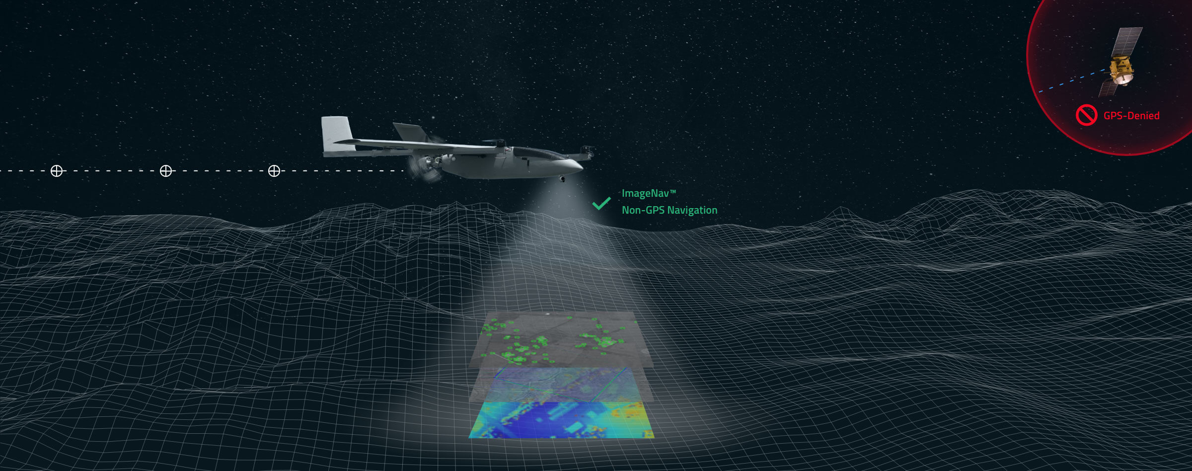
Scientific Systems has released upgrades for ImageNav, an image-based navigation software designed for GPS-denied or compromised environments.
With more than a decade of development, ImageNav offers a robust alternative to traditional GPS navigation for military operations, particularly in contested environments where jamming poses a threat to GPS reliability.
The demand for such technology has become increasingly critical considering enhancements to electronic warfare capabilities, with instances of GPS signal disruption impacting military assets. ImageNav is designed to address GPS vulnerability by offering precise navigation for a wide range of systems, including weapons, aircraft and uncrewed aircraft systems (UAS), without reliance on GPS signals.
ImageNav uses an onboard electro-optical (EO) or infrared (IR) digital camera and can employ three algorithms to analyze captured images and correlate them with stored terrain and image references. This process allows both absolute and relative navigation position updates. The technology can be integrated into air platforms as a software upgrade or as part of a self-contained hardware payload, minimizing size, weight and power (SWaP) requirements.
Scientific Systems is actively pursuing the integration of ImageNav onto GPS-guided munitions and UAS to operate in environments where GPS access is denied. Recent testing has demonstrated the technology’s capability to navigate without GPS and hit targets within required performance parameters.
The Global Earth Observation Decentralized Network (GEODNET) Foundation — the organization governing the blockchain-based global navigation network GEODNET — has completed a $3.5 million seed funding round. The round was led by North Island Ventures, with participation from Modular Capital, Road Capital, Tangent, Reverie, and select angels, who join existing GEODNET backers Borderless, IoTeX and JDI Ventures.
The GEODNET Foundation is building a Global Navigation Satellite System (GNSS) reference network for positioning based on real-time kinematics (RTK). Standard GPS is typically off by two meters; however, devices connected to GEODNET’s global RTK network are designed to achieve instant accuracy within 1 cm to 2 cm. Many internet-of-things (IoT) and autonomous applications, such as UAVs, smart mowers and advanced driver assistance systems (ADAS), have shifted to RTK in place of standard GPS positioning, the company said.
GEODNET is a community-based decentralized physical infrastructure network (DePIN). Anyone can contribute to the network by installing and operating a reference station, known as a satellite miner. Satellite miners are designed to deliver precise RTK correction data to devices equipped with GNSS receivers in a range of approximately 20 km to 40 km. By building and participating in the network, satellite mining operators earn GEOD tokens.
GEODNET has more than 4,000 registered reference stations in more than 2,500 cities across 120 countries. GEODNET aims to provide robust precision navigation systems to a variety of industries, including self-driving cars, agriculture, consumer robots, and more.
In my November 2023 GPS World newsletter, I highlighted the announcement made by the National Geodetic Survey (NGS) of the recipients of the NOAA FY 23 Geospatial Modeling Competition Awards. The grantees’ proposals include developing models to address what NGS denotes as the Intra-Frame Deformation Model (IFDM). The primary objectives of these projects are to modernize geodetic tools and models, as well as to develop a geodetic workforce for the future. A significant improvement in the new, modernized National Spatial Reference System (NSRS) is the time-dependent component being incorporated in the computation of reference epoch coordinates (RECs). That said, developing models that accurately capture the time-dependent component is extremely important to providing reliable, consistent, and accurate RECs. My February 2024 newsletter highlighted NGS’s grant to The Ohio State University for developing a fully kinematic reference frame for the Continental United States and Canada. Similar to the OSU project, a goal of the Scripps Institution of Oceanography (SIO) project is to provide an accurate IFDM, which will provide reliable, consistent and accurate RECs. On Jan. 10, 2024, Yehuda Bock, Ph.D., gave a presentation about this at the general membership meeting of the American Association for Geodetic Surveying (AAGS). His presentation can be downloaded from the AAGS’s website: https://aagsmo.org/.
Summary of the SIO Geospatial Award. (Image: NGS website)
Bock is director of the California Spatial Reference Center (CSRC), which is responsible for “establishing and maintaining an accurate state-of-the-art network of GPS control stations for a reliable spatial reference system in California.” I highlighted the CSRC in my June 2023 GPS World Newsletter.
Yehuda’s proposal included the following three activities:
Create a formal Geodesy Program at SIO to address the nationwide deficiency of geodesists. Expand current geophysics curriculum – funding for five graduate students.
Develop an IFDM to supplement the NSRS for users in regions with significant ground motions, using GNSS and InSAR/GNSS displacement fields (funded by NASA projects) and underlying geophysical models. CSRC will exercise the IFDM through its community of public, private and academic users of precise spatial referencing in our challenging region of secular and transient crustal movements.
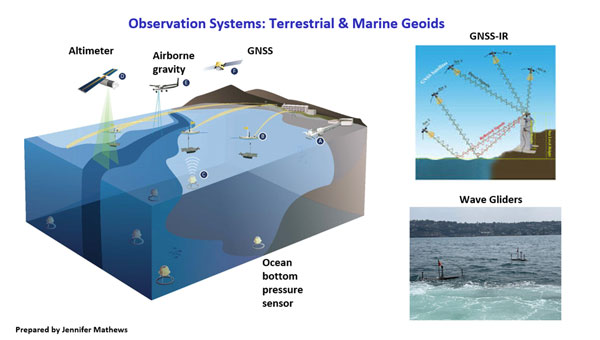
Investigate a unified vertical reference frame, including a marine geoid optimized to be consistent with the full spectrum of observations from modern gravimetric geoids (e.g., GRAV-D, ICGEM), remotely sensed observations (e.g., SWOT, ICESat-2), in situ ocean observations and assimilating ocean models and the TRF.
Yehuda’s project includes creating a formal geodesy program at SIO that will help to address the geodesy crisis. Anyone keeping up with my columns knows that I have been highlighting the geodesy crisis and programs that advance the science of geodesy (July 2020, November 2022, and December 2022).
Yehuda showed a slide that highlighted “What Geodesy Can Tell Us About Earth.” Looking at the slide, geodesists are needed in the field of climatology, meteorology, hydrology, geology, volcanology, oceanography, and glaciology, as well as surveying, mapping, and navigation. All these disciplines study Earth’s dynamic processes and involve geodesy.
From Yehuda Bock Ph.D.’s presentation to the AAGS General Membership Meeting. (Image: AAGS website)
The images “Geodesy Curriculum at SIO (PhD, MSc)”, “Geodesy Courses – 1” and “Geodesy Courses – 2” provide information about the Geodesy Program as SIO.
From Yehuda Bock, Ph.D.’s Presentation to the AAGS General Membership Meeting. (Image: AAGS website)
Notice that some of the courses focus on topics that are important to real world applications. For example, GNSS precise point positioning applications to seismotectonics, GNSS signal propagation applications to atmospheric remote sensing and GNSS reflection: soil moisture and sea level and the vertical datum.
From Dr. Yehuda Bock Ph.D.’s presentation to the AAGS General Membership Meeting. (Image: AAGS website)FromYehuda Bock, Ph.D.’s presentation to the AAGS General Membership Meeting. (Image: AAGS website)
In addition to the graduate-level courses, they are proposing an undergraduate course titled Geodesy and Geospatial Information. The purpose of the course is to provide students with the skills in geospatial systems that will provide opportunities for eventual employment in the public and private sectors.
Proposed Undergraduate Course
Title: Geodesy and Geospatial Information
Course justification and content objectives: Geodesy is the study of Earth’s size (geometry), shape (gravity field) and deformations (e.g., plate tectonic motions, subsidence). It provides access to a well-defined spatial reference system for precise geospatial information (latitude, longitude, height, elevation with respect to sea level) used for positioning, navigation, surveying and mapping. Geodesy is also an important discipline within the earth, atmospheric and oceanographic sciences, using observations of GPS and other satellite navigation constellations, remote sensing platforms (satellite and drone), and various terrestrial sensors. It is a data- and analysis-intensive discipline increasingly requiring modern data science methods. This introductory course will provide students with a solid background in geospatial systems for eventual employment in the public and private sectors. The course will also serve as a pipeline to the geodesy track at SIO/Earth Sciences and to other academic institutions and to alleviate the nationwide deficiency of geodesists. The objective is to provide basic knowledge of geodetic concepts for Earth and data scientists and the underlying geodetic framework for precise spatial information.
Learning objectives:
Acquire basis concepts of geodetic science.
Provide overview of geodetic instrumentation and observations.
Develop elementary skills in geodetic data analysis.
Explore existing geodetic infrastructure and data repositories.
Experience hands on visualization and manipulation of geospatial information.
Understand the underlying geodetic framework for precise spatial information systems.
Provide example of data science applications in solving geodetic problems.
Preferred background: statistics, linear algebra, Matlab/Python
In my opinion, universities should provide a general elective course for undergraduate students that provides an introduction in how geodesy influences your daily routines. For example, how does my phone know where I am and how does it know the best route I should take to get to my destination?
How Does My Phone Know Where I Am? (Image: Dave Zilkoski)
The second task in the SIO proposal is to develop an IFDM. The concept of an IFDM is part of NGS’ modernized, NSRS. Several of my previous My July 2023GPS World newsletter highlighted a presentation by Yehuda discussing a kinematic datum that uses an intra-frame velocity model to estimate positions at any time with respect to a reference frame and epoch.
As I mentioned in my July 2023 newsletter, California’s geodetic network is significantly affected by crustal movement. To help address this issue, the CSRS updated the NAD 83 coordinates, it is denoted as CSRS epoch 2017.5 (NAD 83). Part of the implementation of the CSRC epoch 2017.50 (NAD 83) was to have the new epoch-date coordinates transmitted with RTCM 3.0 data streams. This is something that other RTN operators from around the nation will have to do after NGS publishes the NSRS coordinates. The CSRS is a model from which others can learn.
During his presentation to AAGS, Yehuda highlighted his methodology of integrating InSAR and GNSS to develop an IFDM that provides for higher spatial resolution to improve the model between GNSS stations.
The boxes titled “SCIP Dynamic Datum Utility” and “Output from SCIP Utility” provide an example of an input and output of the utility, and the box titled InSAR/GNSS Integration for Higher Spatial Resolution” is a conceptual diagram of the concept.
Not only has this abbreviation been spelled out before, but here the full phrase appears three times, in three consecutive sentences.
SCIP Dynamic Datum Utility. (Image: SOPAC website)Output from SCIP Utility. (Image: (SOPAC Website)From Yehuda Bock Ph.D.’s Presentation to the AAGS General Membership Meeting (Image: AAGS website)
The image provides an example of the concept in the San Joaquin Valley, California.
InSAR/GNSS Integration Example.
The following statement is in the note section of the slide:
“Area of subsidence in San Joaquin Valley. Our weekly displacement time series at GNSS station P056 shows significant changes in subsidence rate over the period 2006 to 2022, for a total of 3.3 feet that reflects periods of drought and increased groundwater use. On the upper right is the InSAR time series at that location for a shorter period of time.” This shows the potential of using InSAR to improve the IFDM in areas of sparse CORS.
The third item in the proposal is to “Investigate a unified vertical reference frame, including a marine geoid optimized to be consistent with the full spectrum of observations from modern gravimetric geoids (e.g., GRAV-D, ICGEM), remotely-sensed observations (e.g., SWOT, ICESat-2), in situ ocean observations and assimilating ocean models, and the TRF.”
The images below provide a list of the reference surfaces involved in unifying the vertical reference frames and the observing systems involved in the project. Understanding the geoid at the land-sea interchange is important to estimating accurate GNSS-derived orthometric heights along the coast as well as in the oceans. My August 2021 newsletter highlighted the concept of establishing an International Height Reference System (IHRS) so that all countries could provide physical heights across their boundaries and over the oceans. This project would support that international activity.
From Yehuda Bock Ph.D.’s Presentation to the AAGS General Membership Meeting. (Image: AAGS website)From Yehuda Bock Ph.D.’s Presentation to the AAGS General Membership Meeting. (Image: AAGS website)
This newsletter and my previous GPS World newsletter highlighted two of the grantees, \SIO and OSU, which included developing models to address what NGS denotes as the IFDM.
The SIO program includes creating a formal geodesy program at SIO that will help to address the geodesy crisis. In addition to the graduate level courses, they are proposing an undergraduate course that will provide students with the skills in geospatial systems that will provide opportunities for eventual employment in the public and private sectors. My next newsletter will address another NGS geospatial modeling grant awardee – Oregon State University’s proposal.
Iridium Communications, a satellite network operator, will acquire Satelles for $115 million. Satelles is a provider of secure satellite-based time and location services that complement and protect GPS and other GNSS-reliant systems.
While Satelles primarily focuses on providing its satellite time and location (STL) services for digital infrastructure companies, there are potential applications for aviation, the company said. Satelles offers smaller form factor devices that can be integrated with data processing and storage servers to provide critical positioning, navigation and timing (PNT) data.
According to Iridium, the STL service uses the stronger broadcast paging channels of the Iridium satellite constellation to deliver precise timing information. This aims to provide global, secure time and location signals that are more powerful than GNSS constellations, the company continued. The service is resilient to regional GNSS outages, works inside buildings and is being used to secure digital infrastructure for financial markets, governments and major corporations.
The company is now working to reduce the size and cost barriers to improve integration with autonomous systems, consumer devices, vehicles and traditional markets such as aviation, maritime and land mobile. STL can help mitigate GNSS jamming and spoofing, with dedicated STL receivers incorporated into aircraft avionics.
“The most immediate application would be in aviation/Federal Aviation Administration (FAA) ground infrastructure to support PNT resilience in their networks,” Iridium CEO Matt Desch told AIN. “[In the] longer term, there would be an opportunity for avionics providers to build STL into their avionics to protect the integrity of the GPS signals their boxes use and provide a way to tell if GPS signals were compromised or spoofed. We don’t think we’ll be an alternative to GPS or other GNSS applications—only a backup to constantly check signal integrity.”
A long-standing investor in Satelles, Iridium had an ownership stake of 20% from three previous investments in the company. Iridium expects to complete the acquisition in the next few weeks.