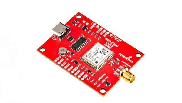
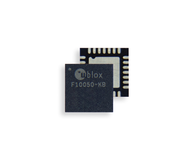
SparkFun Electronics has released the NEO-F10N GNSS L1/L5 Breakout board. This GNSS breakout board features the u-blox NEO-F10N module and a dual-band L1/L5 configuration designed to add precision to GNSS projects operating in urban and rural environments. Additionally, the L5 signal falls within a protected frequency band, which reduces RF interference on the incoming signal.
This breakout supports the concurrent reception of three GNSS constellations: GPS, Galileo, and BeiDou. The proprietary dual-band multipath mitigation technology from the u-blox F10 allows the module to choose the best signals from both bands to achieve a significantly better position accuracy in challenging urban environments than with the L1 band alone.
It has an integrated rechargeable battery that powers the RTC on the NEO-F10N, which reduces the time-to-first fix from cold to hot starts. The battery also maintains RTC and GNSS orbit data without external power to offer uninterrupted performance.
u-blox-based GPS products are configurable using u-center. This offers users extensive customization options such as baud rates, update rates, spoofing detection and more.
Swift Navigation has partnered with Telit Cinterion to enhance the precision of GNSS positioning in low-power consumption devices such as wearables, robotic lawnmowers and vehicle tracking systems.
Under the collaboration, Telit Cinterion’s GNSS receivers will use Swift’s Skylark precise positioning service, which is designed to deliver consistent precision across vast areas while prioritizing energy efficiency, reducing processing demands and minimizing data transmission costs. It aims to provide accurate location information quickly, even in difficult environments such as urban centers and canyons where signals can be obstructed.
This partnership seeks to enhance location-based applications by allowing these devices to achieve centimeter-level accuracy. This level of accuracy is crucial for the safe operation of autonomous vehicles and industrial robots, but integrating it into small, battery-powered devices has been a complex challenge until now.
The solution is designed to comply with industry standards, making it interoperable with various GNSS chipsets, modules, receivers and applications.
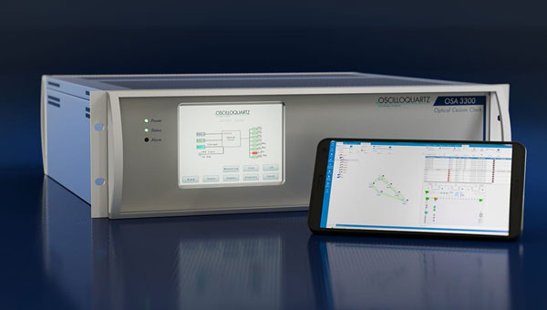
Netnod is implementing Adtran’s coreSync OSA 3300-HP, an optical pumping cesium atomic clock technology to fortify Sweden’s national infrastructure against emerging digital threats. This strategic upgrade aims to enhance the precision and reliability of timing services vital to the nation’s economy, spanning sectors from finance to next-generation telecommunications such as 5G.
Sweden’s leading position in digital services and telecommunications highlights the need for robust timing services, which are fundamental to the functioning and security of digital infrastructures. The introduction of coreSync OSA 3300-HP by Netnod — a company specializing in providing internet exchange, DNS, and time services in the Nordic countries — aims to enhance the accuracy, stability and durability of timing synchronization services across the country.
By deploying Oscilloquartz super ePRC technology across six pivotal timing centers nationwide, Netnod aims to address the growing concern over GNSS vulnerabilities. The optically pumped cesium technology of the coreSync OSA 3300-HP offers a highly stable and precise alternative timing source, providing frequency stability and an operational lifespan double that of traditional magnetic cesium clocks.
ComNav Technologies has introduced the AG502 automated steering system. It integrates advanced satellite reception, positioning, navigation and automatic driving to meet the diverse demands of modern agriculture.
The system consists of a GNSS tablet, an electric steering wheel, two angle sensors and two GNSS antennas, offering a plug-and-play capability with simple instillation and calibration. It is equipped with a ComNav SinoGNSS to support full-constellation and multi-frequency tracking.
It is designed to withstand harsh outdoor agricultural environments. With waterproof and dustproof properties, the system offers weather resistance and durability in diverse conditions.
The AG502 is equipped with connectivity modules, featuring a 4G modem alongside UHF radio. It offers farmers the flexibility to access real-time kinematics (RTK) correction sources from local RTK networks or GNSS RTK base stations. It uses the combined GNSS+INS terrain compensation technology to provide automated steering accuracy, with a precision of 2.5 cm. This level of precision makes the system ideal for tasks such as ditching, planting and harvesting.
For the remotely located or often network-lacking fields, the system offers a reliable precision point positioning (PPP) solution, which supports PPP-HAS and PPP-B2b service. It also features intuitive and user-friendly 2D/3D software, streamlining the learning and operation process for easy start-up. It supports various work modes such as straight, curved, automatic u-turn and pivot to accommodate diverse farmland and work requirements.
ComNav offers comprehensive training videos of the AG502. In the event of technical challenges, users have access to remote technical support or can reach out to local dealers via phone, email or messaging apps for prompt assistance.
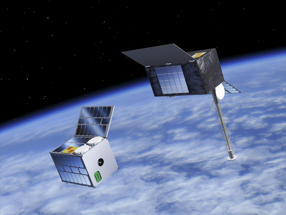
The European Space Agency (ESA) has initiated two navigation missions, Genesis and low-Earth-orbit positioning, navigation and timing (LEO-PNT) as part of its FutureNAV program. ESA has awarded contracts, totaling €233 million, to several European entities to begin the development of the missions. They are designed to address the growing demand for more resilient and precise navigation solutions in Europe.
Genesis, with a contract value of €76.6 million, involves a consortium led by OHB Italia, tasked with the development and operation of the Genesis satellite and its payloads, supported by contributions from Italy, Belgium, France, Switzerland, Hungary and the UK. The satellite is expected to launch in 2028, with subsequent years dedicated to scientific exploitation. Genesis aims to significantly improve the International Terrestrial Reference Frame (ITRF) and offer unprecedented precision for navigation and a myriad of Earth sciences applications.
For the LEO-PNT mission, ESA has distributed €78.4 million for each of the two contracts for the development of in-orbit demonstrators. These LEO-PNT satellites will explore new signals and frequency bands, designed to provide enhanced resilience, accuracy and speed in navigation. The projects are led by GMV Aerospace and Defense and Thales Alenia Space France and involve a broad consortium of more than 50 entities from 14 countries. The first LEO-PNT satellite is expected to launch within 20 months from the project’s commencement, with the complete constellation operational before 2027.
LEO-PNT satellite. (Image: ESA)
Genesis is designed as a flying observatory to refine the ITRF to an accuracy of 1 mm and a stability of 0.1 mm/year, serving as a crucial reference for all space- and ground-based observations. This enhanced reference frame is designed to directly benefit satellite-based systems and applications across various sectors, including aviation, traffic management and autonomous vehicles. It is intended to have have broader implications for meteorology, natural hazard prediction and climate change monitoring.
The LEO-PNT mission aims to establish a small constellation of demonstration satellites to test novel navigation signals and interoperability with GNSS to offer improved signal robustness and extended navigation services to challenging environments such as deep urban areas and indoors. This mission will explore the potential of LEO constellations in supporting a wide range of applications, from transportation and critical infrastructure to mobile devices and asset tracking using advancements in communication standards, such as 5G/6G.
NextNav has entered an agreement to acquire additional spectrum licenses in the lower 900 MHz band (902 MHz to 928 MHz) from Telesaurus Holdings and Skybridge Spectrum Foundation. This acquisition, valued at up to $50 million, significantly expands NextNav’s spectrum portfolio by an additional 4 MHz.
With the completion of this transaction, NextNav’s total spectrum assets will surge to 3.5 billion MHz-PoPs, which marks a significant leap in the company’s capacity to offer reliable and precise positioning and timing solutions.
The transaction involves an initial cash payment of $2.5 million due within 30 days following the court’s authorization to proceed. The balance will be settled in NextNav common stock, contingent upon reaching specific milestones, the final transfer of licenses and obtaining necessary regulatory approvals. The successful closure of this deal is subject to Court and regulatory clearances, including approval from the Federal Communications Commission (FCC).
NextNav aims to deliver PNT solutions that use 3D geolocation and PNT technology, facilitated by its ownership of low-band licensed spectrum. The company’s technologies are designed to ensure accurate, reliable and resilient 3D PNT solutions across a broad spectrum of applications, ranging from critical infrastructure and GPS resiliency to various commercial use cases.
“Seen & Heard” is a monthly feature of GPS World magazine, traveling the world to capture interesting and unusual news stories involving the GNSS/PNT industry.
A child reported missing in Robbinsville, N.J., was found in less than 10 minutes using a UAV equipped with a thermal camera, WPVI reported.
On the night of January 17, Robbinsville Police received a call reporting a missing child last seen running into a heavily wooded area. Officers dispatched the department’s UAV equipped with thermal imaging cameras, which allowed officers to quickly locate the missing boy through thick vegetation after dark. The child was unharmed, according to the report.
Photo: Maxar Technologies
Fire strikes Chile
Maxar Technologies has released satellite images showing the widespread damage caused by raging wildfires in Chile’s Valparaíso region. The fires have killed more than 122 people. The images show entire neighborhoods destroyed east of the resort town of Viña del Mar yet do not show active wildfires. The fires reportedly surged in the Valparaíso region, fueled by winds and an intense heatwave that has seen temperatures of around 40° C.
The UK government has introduced regulations establishing a 400 m UAV “no-fly zone” around prison facilities. The announcement addresses the escalating use of UAVs by criminals attempting to transport illicit items — including phones, drugs and weapons — into prisons.
The initiative is a response to the increase in the number of UAVs detected or sighted within prison grounds, which more than doubled between 2019 and 2021, according to a press statement from the UK government. The implementation of “no-fly zones” aims to enhance law enforcement’s ability to catch organized criminals in the act. Additionally, these measures are designed to prevent illegal aerial filming of prisons.
Photo: Bim / E+ / Getty Images
Back to the fields
GNSS jamming by the Israeli Defense Forces (IDF) has forced retired farmers in the Israeli settlement Mevo Hama to return to the fields. In an interview with CTech, local farmer Rami Laner shared that the younger equipment operators do not know how to operate the modern tractors for spraying or sowing tasks without the aid of their GNSS-based autonomous systems. With the IDF intentionally jamming and spoofing GNSS signals, civilians in the area are in search of alternative PNT systems to protect communities and maintain workflows.
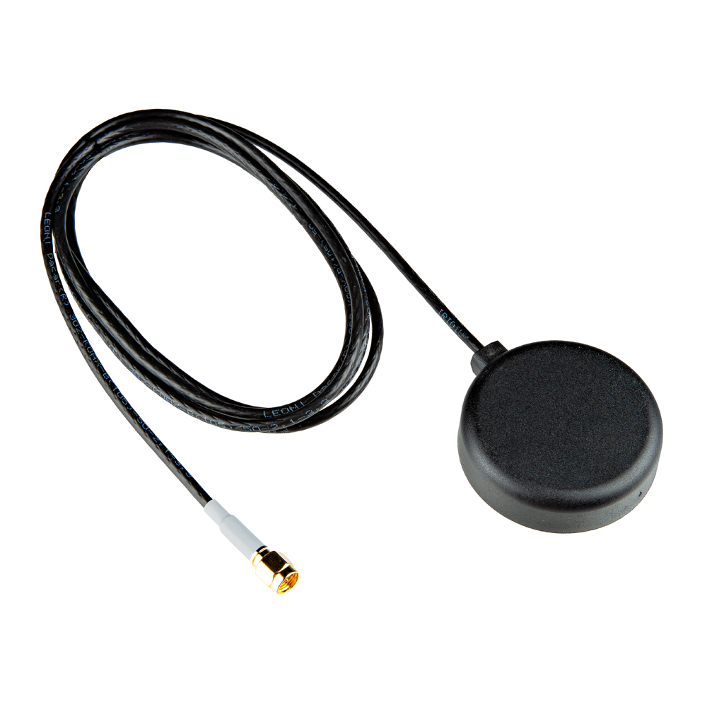
SparkFun Electronics has released the 2J7426MPz by 2J antenna, a high-performance magnetic mount antenna designed to communicate with the Iridium satellite communication system. It is manufactured with high-quality polycarbonate (PC) and acrylic-styrene-acrylate terpolymer (ASA), a thermoplastic combination that offers strong resistance to UV, moisture, and heat and enhances mechanical properties.
The antenna housing is waterproof to IP69 standards and designed to operate in extremely harsh environments, including those with frequent exposure to water, dust and debris. It has a recommended operational and storage temperature of -40°C to +85°C. The magnetic mount allows for easy installation and removal between vehicles or assets, and it is easily converted to an adhesive type for greater flexibility.
It is delivered with a standard SMA-male connector and a standard 300 cm long coaxial LL100 cable. Iridium has certified the 2J7426MPz antenna for commercial use in connection with the Iridium communications system.
Kongsberg Discovery has released the Seapath 385 navigation system. It is designed to enhance precision in hydrographic surveying by using advanced navigation algorithms and integrating a range of satellite signals, including GPS, GLONASS, Galileo, Beidou and QZSS, alongside geostationary satellite signals.
The system combines raw inertial sensor data from Kongsberg Discovery’s proprietary high-performance motion gyro compass (MGC) or motion reference unit (MRU) with GNSS data and corrections from real-time kinematics (RTK), precise-point positioning (PPP) or Differential Global Navigation Satellite System (DGNSS). The integration offers a robust and accurate navigation solution ideal for hydrographic surveying.
The system’s dead reckoning capabilities are attributed to its advanced inertial sensors and updated navigation algorithms. It uses GNSS antennas for both positioning and heading determination designed to add an extra layer of robustness to the system. The Seapath 385 also introduces a new post-processing format that consolidates all necessary data and system configurations into a single file, which allows for centimeter-level position accuracy through either satellite orbit and clock data or data logged from base stations.
Designed for ease of installation and continuous, reliable operation, the Seapath 385 is a modular system with a processing unit that handles all critical computations independently of the user interface on the HMI Unit. This feature offers precise measurements with a data rate of up to 200 Hz at multiple monitoring points, which makes it an ideal solution for accommodating sensors or systems that depend on motion or position data throughout the vessel.
The Federal Communications Commission (FCC) is investigating whether the use of Russian and Chinese foreign satellite systems by U.S. mobile phones and other devices poses security threats.
The FCC has concerns that U.S. handheld devices are receiving and processing GNSS signals from satellites controlled by foreign adversaries in violation of commission rules.
The FCC is seeking answers from handset manufacturers Apple, Google, Motorola, Nokia, Samsung and others that collectively cover more than 90% of the U.S. smartphone marketplace.
“There is no established record of what security threats, if any, these signals carry and whether the manufacturers of handheld devices are processing these signals in violation of the Commission’s rules,” an FCC spokesperson said in a statement.
Representative Mike Gallagher, chair of the U.S. House Select Committee on the Strategic Competition Between the United States and the Chinese Communist Party, wrote FCC Chair Jessica Rosenworcel earlier this week raising concern about reports that U.S. cell phones were receiving and processing signals from Chinese and Russian satellites.
The FCC has only approved U.S. phones to receive and process signals from the U.S. Global Positioning System (GPS) and the European Galileo GNSS.
CHC Navigation (CHCNAV) has released the RS10 handheld SLAM lidar laser scanner integrated with a full real-time kinematics (RTK) GNSS receiver. Designed to improve efficiency across a wide range of mapping and surveying applications, the RS10 seeks to provide professionals with a versatile, all-in-one tool for capturing 3D geospatial data in both outdoor and indoor environments.
The device integrates a GNSS smart antenna for RTK positioning accuracy even in challenging environments. It delivers 5 cm measurement accuracy by fusing high-precision lidar, RTK, laser and visual SLAM using three HD cameras. It uses a powerful onboard processor for real-time georeferenced point cloud generation in the field. Users can receive instant feedback, which allows them to adjust while scanning. Large sites up to 13,000 square meters can be mapped in real time.
The integration of high-precision GNSS and SLAM technologies eliminates the need for traditional loop closure, which often complicates the data collection process for handheld scanners. Users can freely scan target areas without having to return to previous locations, which can streamline field data capture and significantly reduce time spent in the field.
u-blox has introduced the F10 dual-band GNSS platform. It combines L1 and L5 bands to offer enhanced multipath resistance and meter-level positioning accuracy. The platform caters to urban mobility applications, such as aftermarket telematics and micro-mobility.
Applications that use GNSS receivers for accurate positioning are on the rise. Yet, current receivers do not fully perform in urban areas. Accurate and reliable positioning in dense urban environments — where buildings or tree foliage can reflect satellite signals — requires GNSS receivers to mitigate multipath effects. The L5 band’s resilience to these effects aims to improve positioning accuracy. Combined with the well-established L1 band, an L1/L5 dual-band GNSS receiver can deliver a less than 2 m positioning accuracy (CEP50), against about 4 m with the L1 band only. The u-blox team has conducted driving tests in several urban areas and reported significant improvement over GNSS L1 receivers.
The F10’s firmware algorithm prioritizes L5 band signals in weak signal environments to provide reliable positioning accuracy, even when paired with small antennas. The platform is also equipped with protection-level technology that provides a real-time positioning accuracy estimate.
When a cellular modem is extremely close to a GNSS receiver, it can interfere with the receiver’s reception. Some F10 module models, such as NEO-F10N, MAX-F10S, and MIA-F10Q, are equipped with a robust RF circuit that allows the GNSS and the cellular modem to operate without interference.
The u-blox F10 platform is pin-to-pin compatible with the previous u-blox M10 generation for easy migration. It also supports u-blox AssistNow, which offers real-time online A-GNSS service with global availability to reduce GNSS time-to-first fix and power consumption.
The u-blox EVK-F101 evaluation kit will be available in April 2024.