Cepton has released a new lidar solution, Vista-X120 Plus, which is a slim, software-definable, automotive lidar for real-time adaptive 3D perception. This solution will expand Cepton’s line of commercially scalable Vista-X90 lidar solutions and will be deployed in its advanced driver assistance lidar series production program.
The Vista-X120 Plus includes a software-definable region of interest, which enables higher dynamic perception capabilities. Its adjustable central field of view with increased angular resolution improves accuracy in the detection and classification of objects when driving. The region of interest is also configurable in real time in both horizontal and vertical directions.
The lidar solution is 140 x 30 mm, making it slim and compact. The small size improves OEM integration and placement options without disrupting vehicle appearance.
At its <18 W power consumption, the Vista-X120 Plus offers a 200 m range at 10% reflectivity, 120° x 25° field of view, and a data rate of more than six million points per second.
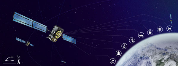
Lockheed Martin has developed a satellite-based augmentation system (SBAS), which uses signals from the GPS and Galileo constellations, according to a report by Space News.
The second-generation SBAS uses both GPS L1 and L5 and Galileo E1 and E5 signals to provide accurate navigation and positioning and to reduce dependence on just one system. The SBAS broadcasts on two frequencies to augment the signals from both GPS and Galileo.
Image: EUSPA
In September 2022, Lockheed Martin won a $1.18 billion 19-year contract to develop and operate the Southern Positioning Augmentation System Network (SouthPAN) for Australia and New Zealand. The company is also having discussions with other potential international customers.
As a part SouthPAN, the dual-frequency multiple constellation SBAS signal is being broadcast. As more GPS III and GPS IIIF satellites are launched, including one Jan. 18, service will continue to improve.
It was 2018. Representatives from the European Space Agency were visiting Google headquarters in Mountainview, California.
Under discussion was Europe’s plans to introduce a high accuracy and authentication service to their Galileo satellite navigation system. Galileo would broadcast precise point positioning corrections on the E6-B band and provide users decimeter-level accuracy. They would also be including a navigation authentication message enabling receivers to distinguish genuine messages from deceptive ones sent by spoofers.
Wouldn’t Google like to incorporate these capabilities in future versions of Android phones?
The answer from Google Distinguished Engineer, Frank van Diggelen, was a resounding “yes.”
Technologically Possible
Van Diggelen also had another thought. It should be possible to deliver precise positioning corrections and authentication data via the internet. This could allow phones with an internet connection to access the services as well. With an app, older smartphones would be able to take advantage of the services, and it wouldn’t be necessary to add new hardware to new phone designs.
The next logical step was to establish an internet-based high accuracy and authentication service for the United States’ GPS. Unlike the newer European Galileo and Chinese Beidou systems, GPS satellites don’t have the ability to transmit data to improve accuracy and authenticate signals.
Yet a couple of process challenges in the United States could make establishing such a service difficult and might prevent its creation entirely.
Data collection and use not yet an official program
The first is related to the way in which the U.S. collects and handles real-time tracking data of the Global Navigation Satellite Systems (GNSS) — GPS, GLONASS, Galileo, and BeiDou — to derive corrections needed for a high accuracy service.
NASA’s Jet Propulsion Laboratory (JPL) operates NASA’s Global GNSS Network (GGN) of more than 60 stations around the globe, which provide their tracking data to JPL’s Global Differential GPS (GDGPS) System. The GDGPS System also has access to real-time tracking data from hundreds of additional sites, all of which track GPS and other GNSS. This allows the GDGPS System to generate precise corrections for the navigation messages of GPS and other GNSS. It also enables real time decimeter-level accuracy for positioning applications anywhere in the world. These corrections are provided to some government agencies and commercial entities on a reimbursable basis.
NASA’s GDGPS capabilities are not part of a formal, official government program, though. Rather they have grown organically as part of JPL’s efforts to push boundaries in scientific and engineering applications of GNSS, and its ability to take on work paid for by other agencies. Thus, GDGPS efforts lack a sufficient and established government funding line, formal programmatic tasking, and other structures and procedures needed to ensure its long-term viability as a government-provided service.
NASA and JPL officials recognized this and in 2020 established a working group to advise on how they should go forward. The following year that working group made several recommendations to NASA and the PNTAB. Among them were to establish a consistent level of NASA funding, create a Level-1 capabilities document for GDGPS, and start discussions towards an interagency memorandum of understanding (MOU) for long-term government funding.
At the same time, a PNTAB task force investigated the GDGPS activity and made recommendations to the PNTAB. They included: that NASA/JPL document GDGPS capabilities, including architecture, facilities, functions and products; that a stable government funding line for GDGPS be established; that a security review of GDGPS be undertaken; and to maintain GDGPS entrepreneurial aspects in pursuing multi-agency usage of its services.
Civil GPS rarely needs addressed
The second challenge to establishing high accuracy and authentication service for GPS appears to be the lack of an identified agent or mechanism within the federal government to do so.
Europe’s Galileo is a civilian system established and operated to support economic activity and development. The U.S’s GPS is run by the military.
First created to “put five bombs in the same hole,” it was built and run for years by the U.S. Air Force and is now the responsibility of the U.S. Space Force. Its primary mission is support of military missions and almost all funding comes through the Department of Defense (DOD).
Yet, indisputably, 99% of GPS users are not in the military and the system has become essential to most technologies and nearly every facet of the U.S. economy.
Official government policy has long recognized this, at least at the strategic level. Presidential policies issued in 2004 and in 2021 provided for improvements in functionality for civil users – as long as they were required by and entirely funded by a civil agency.
At a more tactical level, though, attempts to fund civil requirements have always faced great difficulty and rarely succeeded.* Mandates in presidential directives for civil signal monitoring, interference detection and mitigation, increased resilience, alternative PNT, and responsible use have all faced uphill battles and received little funding.
According to former senior government officials, this difficulty stems from civil GPS use being caught in a bureaucratic “Catch-22.”
On the one hand, executive branch policy dictates that funding for GPS capabilities and applications benefiting civil users must flow through the Department of Transportation (DOT). On the other, within government programming and budgeting circles, GPS is seen as an expensive military capability funded through the DOD. Requests for GPS and PNT-related funding through DOT are more difficult to explain and are easier to deny.
Compounding this difficulty is the lack of a clear and empowered national leader to advocate for a comprehensive and national approach to GPS and PNT issues and overcome bureaucratic snags.
As a result, the path forward for adopting the recommendation for a GPS high accuracy and resilience service is, at best, unclear.
Yet many on the President’s advisory board and in government are hopeful. “Establishing a high accuracy and resilience service for GPS is the right thing to do” said one. “We have all the pieces to make this happen. We just need to bring them together.”
And as one of the board members commented at the recent meeting, if the U.S. doesn’t do this “It stinks.”
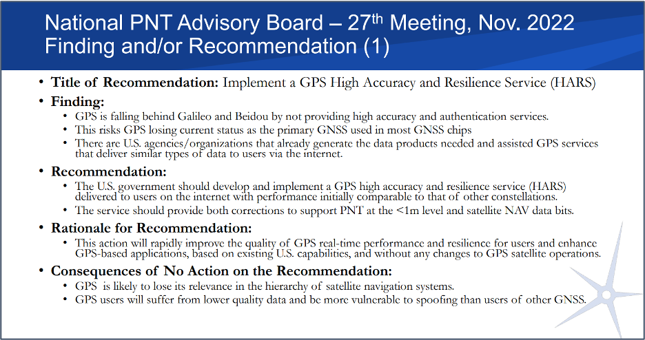
Image: Slide from the National PNT Advisory Board Meeting in November 2022
*The exception to difficulties funding civil GPS-related capabilities is the Federal Aviation Administration’s Wide Area Augmentation System. It was established as the result of heavy lobbying by the airline industry, which continues to give it strong support.
Another autonomous lawn mower has hit the field. The RoboUp (made by a company of the same name) is offering a no-perimeter-wire real-time kinematic (RTK) artificial intelligence (AI) robot lawn mower.
The mower uses an RTK module built into the charging station and AI real-time recognition support to automatically measure and profile a yard without any perimeter wiring or other installation.
RoboUp’s dynamic exact positioning system integrates RTK, visual simultaneous localization and mapping (SLAM) and an inertial measurement unit (IMU) to offer precise positioning with centimeter-level accuracy. It can also detect boundaries and identify obstacles and will stop cutting when it reaches either.
The robot lawn mower is powered by a maintenance-free brushless motor, which enables it to climb a 45% slope and cut different types of lawns, including over tough terrain. RoboUP is equipped with adjustable cutting heights of 30 mm to 60 mm and 20 cm width and can adjust the height of the cutting disc to match the terrain.
The mower can be controlled with its own app, which identifies the conditions of the user’s yard and generates a recommended cutting schedule. Additionally, it integrates with smart home systems and can be controlled by voice commands.
The U.S. Space Force (USSF) has delivered two payloads to Japan for the Quasi-Zenith Satellite System (QZSS). The payloads will be integrated into two QZSS host satellites being prepared for launch, which will expand the QZSS constellation from five to seven satellites.
The QZSS hosted payload (QZSS-HP) is central to the USSF priority of expanding cooperation to contribute to international security. The mission is managed by the Space Domain Awareness and Combat Power Directorate (SDACP) of the Space Systems Command (SSC) within the USSF.
Massachusetts Institute of Technology’s Lincoln Laboratories (MIT/LL) is the primary payload developer for the QZSS-HP. MIT/LL and USSF personnel will travel to Japan to support the integration and test efforts with Japanese partners until both QZSS host satellites are launched.
Movella, a leading provider of sensors and software, has launched a partnership with Fixposition, a manufacturer of precise positioning sensors. The partnership aims to develop and commercialize GNSS inertial navigation sensors and implement visual inertial odometry through new products.
In December 2022, Movella and Fixposition launched the first product from the partnership, the Xsens Vision Navigator. This product integrates position inputs from three high-accuracy sources including dual-antenna RTK GNSS receivers, an IMU incorporating a three-axis accelerometer, gyroscope and magnetometer and a visual inertial odometry system.
The Xsens Vision Navigator can optionally accept inputs from an external wheel speed sensor. The positioning sensor achieves centimeter-level accuracy when operating in GNSS mode with an RTK fix. When GNSS signals are not available, the product alone achieves an accuracy of 2% of travel distance, or 0.75% when supplemented by wheel speed.
Xsens Vision Navigator is suitable for outdoor positioning applications such as material handling equipment, commercial and specialist vehicles, last-mile delivery, inspection equipment and UAVs, agricultural equipment, mining equipment and utility robots.
Xsens Vision Navigator is available now from Movella or authorized distributors of Xsens products.
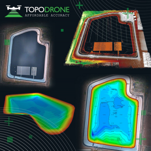
On Jan. 12, TOPODRONE used its synchronized lidar, airborne photogrammetry and bathymetric surveying methods to study a floating solar farm in Israel. This was completed upon request from the UAV service provider ERELIS, to help conduct a pilot project of reservoir surveying with a UAV for ETZ HADEKEL in northern Israel.
As the surface of the reservoir in Northern Israel is covered by solar panels, it is difficult to use standard methods of surveying from a boat. The goal of this study was to create 3D models, which can be used for high-precision assessments of sediment volumes, general monitoring of reservoir banks and visual monitoring.
Image: TOPODRONE
During this project, ERELIS performed two-stage UAV surveying to create the 3D model of the reservoir. In the first stage, aerial photogrammetry and lidar surveys were performed using a DJI M300 UAV. The UAV was equipped with the P61 TOPODRONE camera and a lidar high-resolution system to determine the location of obstacles. The lidar scanning provided accurate detection of cables in the water.
The second stage included an underwater bathymetric survey using the TOPODRONE AQUAMAPPER mounted to the DJI M300 UAV. The flight mission was planned and executed with the UgCS software by SPH Engineering.
All data collected from the study was processed by TOPODRONE Post Processing software. This generated a georeferenced orthophoto map, a 3D model of the relief and objects, a 3D model of the bottom of the reservoir and a model of contour lines and isobaths.
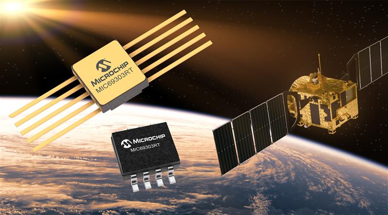
Microchip Technology has launched the MIC69303RT 3A Low-Dropout Voltage Regulator, a radiation-tolerant power management device for space application developers. This high-current, low-voltage device targets low-Earth orbit (LEO) space applications.
The MIC69303RT operates from a single low-voltage supply of 1.65 v to 5.5 v and can supply output voltages as low as 0.5 v at high currents. It offers high-precision and low dropout voltages of 500 mv under extreme conditions. The MIC69303RT is a companion power source solution for Microchip’s microcontrollers, such as the SAM71Q21RT and PolarFire field-programmable gate arrays.
This device is designed for harsh aerospace applications and remains operational in temperature ranges from -55 C to +125 C. It is offered in 8-pin and 10-pin package configurations with radiation tolerance up to 50 krad.
Additionally, the MIC69303RT is manufactured in compliance with MIL Class Q or Class V requirements, including screen testing, qualification testing and more.
The MIC69303RT is available for prototype sampling in both plastic and hermetic ceramic. The plastic MIC69303RT is compliant with high-reliability plastic quality flow derived from AEC-Q100 automotive requirements with specific additional tests necessary for space applications.
This device is available in limited sampling upon request.
MGISS, a United Kingdom-based geospatial technology company, has launched the Interruption Prevention Alert Service (IPAS) project to help minimize disruptions to gas and water supplies in the UK. The European Space Agency (ESA) has partly funded this project, which will run for two years to test its technical and commercial viability and to develop a go-to-market plan.
As gas and water outages caused by construction are a growing problem in the UK, IPAS will offer a preventative solution. By leveraging satellite data and services, IPAS will automatically detect changes to the built environment and alert utility providers. The IPAS is expected to be a cost-effective solution and help utility providers reduce carbon emissions.
MGISS is collaborating on this project with Geospatial Insight, its data partner, Northumbrian Water Group (NWG) and Northern Gas Networks (NGN), its client partners, and funding partners including the ESA and the UK Space Agency (UKSA).
The launch of the pilot project is the result of a joint workshop with ESA and NWG’s 2020 Innovation Festival, and two years of ongoing collaboration with NWG and NGN.
Image: Vincent Ryan/iStock/Getty Images Plus/Getty Images
The annual European Navigation Conference (ENC23), set for May 31-June 2, will be hosted by the European Space Agency (ESA) at its ESTEC facilities in Noordwijk, The Netherlands. Abstracts are due no later than Jan. 24, and notification of acceptance or rejection will be sent out by the end of February.
This year’s conference will focus on resilient navigation. Organized by The Netherlands Institute for Navigation (NIN), the conference will address resilience in the broadest sense, including navigation sub-functions, operational routines, standards and policies.
The ENC23 tech committee has broken down the overarching theme into a range of topics, including integral end-to-end navigation solutions, specifics in position, navigation and timing (PNT), routing, data integrity questions and more.
Early-bird registration is open now and ends March 15. General registration begins thereafter and the deadline to register is May 21. For more information about registration and abstract submission, visit the ENC23’s website.
On Jan. 6, HERE Technologies, a location data platform, announced its collaboration with Amazon Web Services (AWS), a leading cloud platform. This collaboration will deliver improved performance for indoor and outdoor positioning capabilities, enabling AWS third-party developers to track and manage internet-of-things (IoT) devices.
HERE Positioning enables developers to switch between different localizing technologies, and it does rely exclusively rely on GNSS for the location of a device or application. This is being integrated with the AWS IoT Core Device Location feature, which makes it possible for developers to track and manage IoT devices without relying on GNSS/GPS hardware.
The integration of the two platforms makes devices and applications location-aware globally with a high-level of positioning accuracy and data security.
HERE Positioning maintains a global database of more than 200 million Cell-ID and 5.6 billion Wi-Fi access point locations, which is updated and populated through machine learning algorithms. It supports a variety of device types, regardless of operating system, using Wi-Fi and cellular networks.
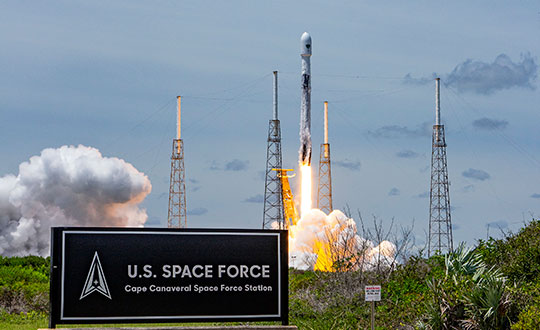
GPS III Space Vehicle 06 (SV06) was launched Jan. 18 from Cape Canaveral Space Force Station in Florida at 7:24 a.m. EST. It is the 18th GPS satellite to broadcast the L5 signal. On Jan. 12, the Space Force Space Systems Command (SSC) had completed encapsulation of SV06 within the Falcon 9 payload.
The launch of SV06 contributed to the SSC’s objective to create resilient GPS, which ensures all users have access to stable positioning, navigation, and timing (PNT) services. SV06, also known as SVN-79, will go through extensive on orbit testing after being introduced into the operational constellation on or about Jan. 25.
Lockheed Martin Space Systems is the main contractor for the GPS III SV06 space vehicle and SpaceX provided launch services. This is Falcon 9’s fifth GPS launch since SpaceX launched GPS III-2 in December 2018.
SV06 is named after the daring pilot Amelia Earhart — the first woman to fly solo across the Atlantic Ocean and to attempt to circumnavigate the world.
The next launch — GPSIII-07 — will take place in 2024.
Constellation Changes. The U.S Space Force Second Space Operations Squadron (2 SOPS) indicates that GPSIII-06, SVN-79/PRN-28, will expand the A2 node in the A plane. It will be identified as position A2F in the vicinity of SVN-52.
SVN-41/PRN-22, forecast unusable until further notice (FCSTUUFN) on Jan. 23, is being set unhealthy and will be used as a test vehicle in AEP.