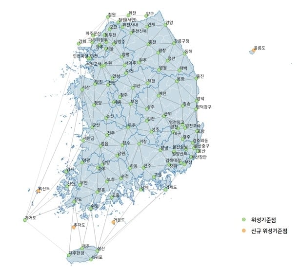
South Korea has launched a test operation of a new GPS-based positioning service, reports the Korea Herald. The Gridded Virtual Reference Station (G-VRS) works without an internet connection to provide real-time location data with centimeter-level accuracy.
The G-VRS will complement the current VRS system for users in remote areas with unstable internet connections — islands, mountains or fast-moving vehicles.
GNSS control points have been installed across the country, including four on Jeju Island and one in Gageodo, an island off the southwestern coast. The state plans to install additional points on four islands, including Ulleungdo, about 120 kilometers off Korea’s eastern coast, to operate 103 control points in total by the end of this year.
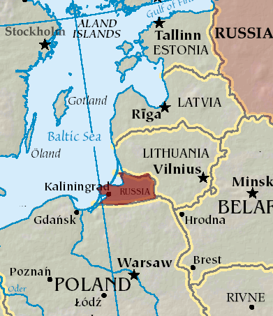
An A330 airplane carrying Spanish Defence Minister Margarita Robles experienced GPS interference while flying over Kalingrad, Russia, reports EU Today. The news outlet cites Spanish newspaper El Mundo as its source.
Robles was flying to in an aircraft belonging to the Spanish Air and Space Force. It was is “subjected to an attempt to throw it off course using GPS” over Kaliningrad as Robles was travelling to the Šiauliai air base in Lithuania on Sept. 24.
The pilot said incidents attempting to disorient pilots have been common for both commercial and military flights over Kaliningrad. Becausee this was a military craft, the plane was receiving instructions from a military satellite and the attempt failed.
Taoglas has expanded of its Comet Series with the MA58x family of compact, discrete, screw- or through-hole mount puck antennas.
Metal structures or flat surfaces, such as cabinets, can affect antenna performance and change the electrical groundplane. The Comet MA58x series is specifically engineered to maintain stable, high-efficiency operation in these challenging conditions.
Conventional LTE antennas rely on their RF cable to achieve low-band efficiency, particularly when the cable itself is routed inside a metal enclosure, turning it into an unintended radiator. The MA58x design removes this dependency, enabling efficient radiation and delivering at least 20% better performance than comparable alternatives.
With a footprint of 101 x 101 mm and low profile of 20 mm, the antennas deliver reliable multi-antenna connectivity across GNSS constellations including GPS, GLONASS, Galileo, and BeiDou, as well as 5G/4G MIMO and Wi-Fi 6/7. Advanced RF design enables consistent gain and efficiency across global cellular frequencies from 600 MHz to 6 GHz and Wi-Fi bands up to 7.125 GHz, while also supporting legacy 2.4/5.8 GHz Wi-Fi and Bluetooth for maximum compatibility. These levels of performance are rarely achieved in antennas of this size, and even more so when installed on metallic structures.
The rugged, weather-resistant housing is molded in Acrylonitrile Styrene Acrylate (ASA) for long-term outdoor durability, and the IP67-rated enclosure with a screw/stud mount provides a permanent installation option that ensures secure, reliable operation in vibration-prone and harsh conditions such as fleet vehicles, heavy equipment, and industrial automation.
The new antennas are available in multiple configurations and in either black or white enclosures. Custom cable lengths and connector options are also offered, making integration more flexible for OEMs and system designers. The MA58x series is suited to gateways and routers, public safety systems, point-of-sale terminals, digital signage, smart home automation, robotics and industrial automation. The Comet Series also offers a magnetic mount MA32x variant to address different deployment needs.
Further details on the design principles that deliver these performance gains are available in a Taoglas white paper.
TSR Inc. (Tactical Surveillance Reconnaissance) has launched the AVRIO series autonomous drone systems — cutting-edge European-made unmanned aircraft designed to redefine aerial surveillance, reconnaissance, and precision-strike capabilities.
The AVRIO family, which includes the Falcox and Nebris platforms, delivers unmatched performance and resilience for defense, security and critical infrastructure missions, according to TSR. The company designed the AVRIO series for a wide range of defense and homeland-security missions, including:
Border security and coastal defense
Rapid-response reconnaissance and force protection
Counter-UAS operations using RF seeker payloads
Critical infrastructure protection and disaster-response intelligence.
“The AVRIO series combines European aerospace engineering with U.S.-based deployment and support, giving governments and security agencies a next-generation toolset for ISR and tactical defense,” said Rick Clarke, CEO of Safe Room Designs/TSR Inc. “This is autonomous aerial defense, reinvented.”
Quick-launch and versatility. Vertical takeoff and landing, <1-minute preparation, runway-independent operation, and mission abort/return-to-base features.
Extended reach. Endurance of up to three hours and a range of up to 30 km, depending on payload and mission configuration.
Precision engagement. Options for smart munition payloads with precision super-quick impact fuzes and effective 15 m radius, plus anti-personnel and armor-piercing warheads.
Resilient design.Low radar cross section, GNSS-denied operation, MIL-STD-810G-qualified ground control, and operational temperature from –20 °C to +50 °C.
Naval and special missions. Capable of surface-mine detection, sweeping operations, and beyond-line-of-sight (BLOS) intelligence gathering.
TSR is now accepting government and defense-sector inquiries for the AVRIO Falcox and AVRIO Nebris systems. For detailed specifications, demonstrations, or procurement discussions, contact TSR.
Ukraine unveiled its TLK-1000 underwater drone — capable of striking targets as distant as 2,000 km (1,240 miles) away — at the Defense Tech Valley 2025 exhibition in Lviv on Sept. 19.
While the torpedo drone itself moves underwater, it has surface elements including antennas for receiving GPS signals, video and thermal imaging cameras, and communication equipment, reported Militaryn in February, when Ukraine President Volodymyr Zelensky first introduced the Toloka drone at the Support Ukraine summit. Designed for stealth operations just below the surface, it uses electric propulsion to evade detection and penetrate Russian defenses.
Kyiv has repeatedly used maritime drones to inflict heavy losses on Russian assets in the Black Sea, according to Defense Express. The TLK-1000 could threaten the Crimean Bridge, a supply and transport route for Russian forces to occupied territories, as well as Russian submarines.
There are three models of Toloka. The largest, TLK-1000, is 12 meters long with a warhead payload of up to 5,000 kg and a range up to 2,000 km (1,240 miles). It is built for long-distance missions and heavy loads. It navigates with GNSS supplemented by AI-INS with a Doppler Velocity Log (DVL).
The TLK 400 also navigates with AI-INS with DVL and GNSS. It is 4 to 6 meters long, its payload can be up to 500 kg, and its range can be up to 1,200 kilometers. The TLK-400 features a hybrid propulsion system and is intended for reconnaissance, mining, signal relay and strike operations.
The TLK 200 navigates with GNSS + AI-INS. It is 2.5 meters, its range 100 km, and its payload 20 to 50 kg of explosives. Typical tasks include reconnaissance, mining, short-range strike missions and radio-relay support.
Maxar Intelligence is partnering with Taiwan’s Aerospace Industrial Development Corporation (AIDC) to deploy the Maxar Raptor software suite across Taiwan’s unmanned aerial vehicle (UAV) industry. The move will help the country accelerate the resilience and reliability of autonomous systems in GPS- and GNSS-denied environments.
Raptor is a vision-based software suite that enables autonomous drones to navigate precisely and extract accurate ground coordinates in the absence of GPS. Designed for lightweight integration with any autonomous platform, Raptor products use a drone’s native camera and Maxar’s 100 million-plus sq km of global 3D terrain data to help the platform navigate with extreme precision and extract accurate ground coordinates in real-time without GPS. Raptor can operate at night and in low-altitude flight operations without the need for any additional hardware.
The partnership follows a successful field demonstration of Raptor software in Taiwan earlier this year, in which the test platform was able to maintain precise navigation under GPS-denied conditions using only its native camera and Maxar’s software.
The test platform was able to maintain precise navigation under GPS-denied conditions using only its native camera and Maxar’s software.
“Taiwan is rapidly building one of the most advanced UAV industries in the world, and AIDC is one of the companies leading the charge,” said Anders Linder, general manager, International Government at Maxar Intelligence. “Taiwanese UAV manufacturers are acutely aware of the importance of building resilience against GPS jamming, and AIDC has validated the unique capabilities of our Raptor software. By combining our geospatial intelligence with AIDC’s aerospace expertise, we’ll help Taiwan’s UAV industry maintain its forward momentum, accelerating autonomy across warfighting, humanitarian, and commercial operations.”
AIDC will drive the adoption of Raptor across Taiwan’s UAV supply chain and promote use of the software across the Taiwan Excellence Drone International Business Opportunity Alliance (TEDIBOA), an organization that AIDC chairs.
“This collaboration opens a new chapter for precision vision-based positioning in Taiwan’s UAV sector,” said AIDC President Chin-Ping Tsao. “We will jointly build a Taiwan-focused integration and testing center, highlight GPS-jamming resilience as a core differentiator, and unlock opportunities across Taiwan and the broader Asia market — advancing both defense resilience and commercial value.”
PlanetiQ, a provider of commercial weather and space weather data, has been awarded a $24.3 million contract from NOAA’s National Environmental Satellite, Data, and Information Service (NESDIS). The award, issued under the Commercial Data Program’s Radio Occultation Data Buy 2 (RODB-2), is NOAA’s single largest commercial satellite weather data purchase.
Under the agreement, PlanetiQ will deliver 7,000 GNSS-RO profiles per day, including 500 enhanced high-signal-to-noise ratio (SNR) profiles as well as 2,500 low-latency Total Electron Content (TEC) tracks daily. Data deliveries began Sept. 18.
“I founded PlanetiQ because radio occultation is one of the few technologies I’ve worked with that tangibly improves the human condition. It’s gratifying to see this capability recognized and scaled.”
GNSS-RO data from PlanetiQ provides precise vertical profiles of the atmosphere across the globe, over land and sea, and in cloudy and clear conditions. It is recognized as the most impactful satellite data input for weather forecast models. GNSS-RO has become critical to space-based climate monitoring, improving and stabilizing weather prediction and atmospheric research over the past several decades.
The 500 enhanced high-SNR profiles per day are especially valuable in the lower troposphere, where measurement and forecast accuracy are often most challenging, further enabling actionable decisions and operations planning with reduced risk.
TEC data additionally strengthens NOAA’s space weather monitoring and forecasting capabilities.
“This award demonstrates NOAA’s confidence in our ability to deliver both the quantity and quality of data needed to advance weather and space weather forecasting,” said Ira Scharf, chief executive officer of PlanetiQ. “We are proud to expand our support for NOAA and its mission to protect life and property.”
The new contract represents a threefold increase in PlanetiQ’s data deliveries compared to its most recent NOAA award, which provided 2,200 profiles per day, and is adding the enhanced SNR and TEC tracks as new products. PlanetiQ collects thousands of profiles daily across the planet and plans to expand its constellation of satellites in the future.
PlanetiQ is excited that organizations running numerical weather prediction, and especially AI forecast models, are recognizing the value in high-quality GNSS-RO data. “Our ability to provide enhanced high-SNR profiles, at seven times the SNR of any other commercial company, sets us apart,” said Chris McCormick, president and chairman of PlanetiQ. “I founded PlanetiQ because radio occultation is one of the few technologies I’ve worked with that tangibly improves the human condition. It’s gratifying to see this capability recognized and scaled.”
While NOAA is the procuring agency of the GNSS-RO data, it will also be used by NASA, the U.S. Air Force, the U.S. Navy, and international government weather agencies for operational and research purposes.
This award underscores the critical role of public-private partnerships to bring new capabilities online faster and at a lower cost to strengthen national forecasting and research. PlanetiQ also partners with leading commercial technology companies and data providers.
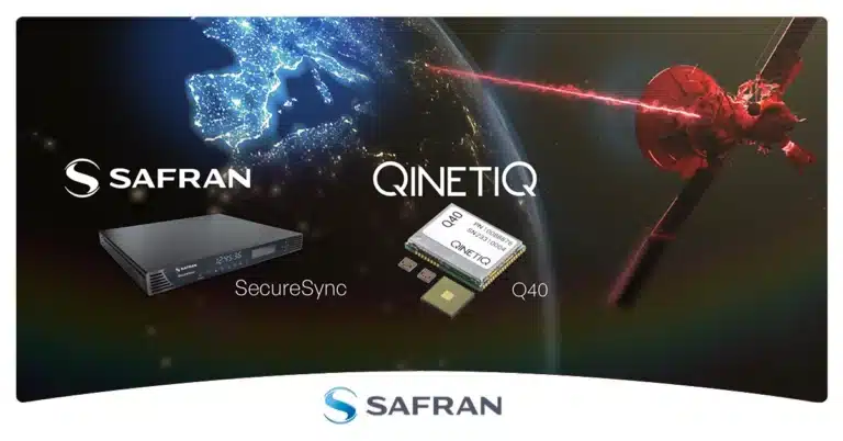
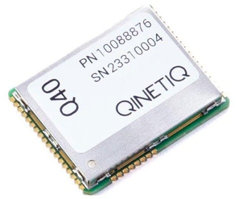
Safran Electronics & Defense and QinetiQ have entered a strategic partnership to deliver sovereign and resilient positioning, navigation and timing (PNT) solutions for the United Kingdom Ministry of Defence. The collaboration addresses today’s urgent need for trusted PNT capabilities in increasingly challenging and GNSS-denied operational environments.
By integrating QinetiQ’s Q40 GNSS receiver with Safran’s SecureSync time server, the partnership offers advanced protection against jamming, spoofing and other adversarial electronic warfare threats. The joint solution supports multi-signal reception and delivers reliable, coherent synchronization for mission-critical military operations — from strategic headquarters to frontline forces.
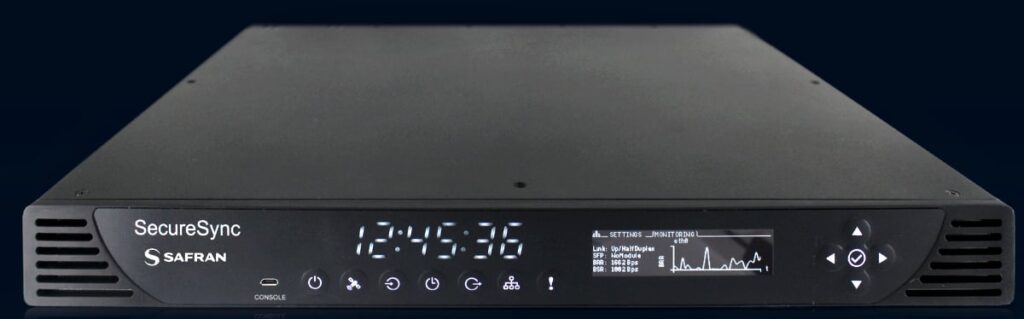
The SecureSync time server. (Photo: Safran)
This next-generation, sovereign capability strengthens the UK’s operational advantage, ensuring continuous access to secure timing and navigation, even under electronic attack. The solution is designed to adapt and expand, accommodating future threats and supporting the full spectrum of defence operations.
“The Q40 provides navigational assurance in environments where jamming, spoofing and electronic attacks are ever-present,” said James Willis, chief executive UK Intelligence, QinetiQ. “By pairing it with Safran’s SecureSync, we are giving UK forces a trusted, sovereign solution that ensures precise timing and navigation data remains available when it matters most.”
The Q40 GNSS receiver. (Photo: Qinetiq)
“In the current context of evolving threats and contested environments, guaranteeing sovereignty in navigation and timing is more critical than ever for national defence,” added Maxime Gorlier, director of PNT Business Unit for Safran Electronics & Defense. “This partnership enables UK armed forces to maintain full independence and sovereignty, even when facing sophisticated electronic warfare tactics. Together, we are committed to providing future-proof PNT solutions that strengthen the UK’s resilience and strategic autonomy.”
The partnership leverages both companies’ sustained investment in customer-focused research, development and innovation, and demonstrates their shared commitment to providing robust, secure and resilient PNT solutions.
PLD Space, based in Elche, Spain, has been selected by the European Space Research and Technology Centre (ESTEC) for its first Guidance, Navigation and Control (GNC) contract. Under this contract, the company will develop HALCON (Hybridization Algorithms and Low-cost Components for Optimized Navigation), a new hybrid navigation software for reusable launch vehicles.
ESTEC is part of the European Space Agency (ESA). The project has been approved under NAVISP Element 2, a key ESA initiative to enhance European competitiveness in positioning, navigation and Timing (PNT) technologies.
The contract, with a total budget of €995,705, will be co-funded equally by ESA and PLD Space, which will retain ownership of the final development.
GNSS-IMU System for Reusability
The HALCON project aims to develop advanced software that combines inertial measurement unit (IMU) data with GNSS signals to achieve precise navigation during rocket launch and landing, a critical capability for reusable launchers such as MIURA 5 and MIURA Next.
Traditionally, IMU-only systems have been costly, less accessible, and less accurate over long operational periods. By integrating GNSS signals (such as Galileo or GPS), PLD Space will develop its own, more affordable and more precise navigation system, optimized for controlled landings — an essential step towards advancing the reusability of space vehicles.
Image: PLD Space
“This project represents a strategic step forward in the development of our own navigation capabilities,” said Raúl Verdú, co-founder and chief business development officer of PLD Space. “With ESA’s support, we will enhance landing maneuver precision, gain vertical integration, and move towards the future integration of autonomous flight termination technologies in Europe.”
The proposal was selected under ESA’s NAVISP Spanish Call, launched in November 2024, arranged both by the Spanish Space Agency (AEE) and ESA. The call invited Spanish industry to propose innovative projects in the PNT field. PLD Space’s contract follows a rigorous technical and commercial assessment and has been favorably evaluated for its alignment with market demand, the competitiveness of the solution, and the strength of its commercialization strategy.
Technology for Europe’s Future in Space
The HALCON system will deliver centimeter-level positioning accuracy, enhancing both safety and operational efficiency. It is based on commercial off-the-shelf (COTS) components, significantly reducing development costs compared to traditional high-end solutions.
This technology will not only improve the reliability and sustainability of space transportation but will also pave the way for future capabilities such as a European Autonomous Flight Termination System (AFTS), which is not yet authorized on the continent. This capability is critical for increasing flight autonomy and mission safety in complex scenarios, while positioning Spain as a leader in next-generation launchers.
The development will be carried out entirely in-house by PLD Space’s engineering team, with ESA’s technical support, and will be integrated into the company’s technology roadmap, aligned with its reusability and operational autonomy plans through 2030.
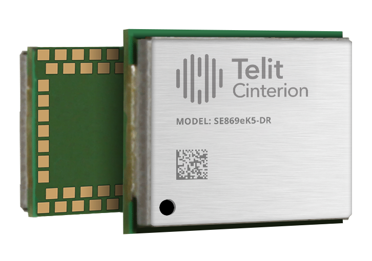
Telit Cinterion, an end-to-end IoT solutions enabler based in Irvine, California, has launched the SE869eK5-DR, a dual-band, multi-constellation positioning receiver with untethered dead reckoning (UDR) built on the Airoha AG3335 chipset family.
The UDR ensures reliable, continuous positioning even when satellite signals are lost due to jamming, interference or physical obstructions, delivering continuous and reliable location data for mission-critical applications without depending on a car connection.
With its power-efficient design, the module is ideal for mission-critical applications in business and government that demand ultra-reliable location information, and long battery life. Applications include fleet management, automotive telematics systems, and high-value asset tracking, where uninterrupted and precise location data is critical for operational efficiency.
Building on the successful Telit Cinterion SL869 series, the SE869eK5-DR adds an integrated six-axis sensor for UDR. This allows the module to maintain a position fix even when signals are blocked or jammed, able to track high-value assets deep inside buildings or in underground parking garages.
The SE869eK5-DR also supports L1 and L5 bands, which maximizes resiliency through frequency redundancy. If one band’s signals are degraded by physical obstructions, the other band provides an alternative set of signals. The module also supports differential GNSS (DGNSS) positioning for applications that require sub-meter-level accuracy.
The SE869eK5-DR includes features that streamline product development. Its UDR technology is simple to integrate because it doesn’t require any external application information, which shortens the design phase. It also automatically identifies the direction of movement (forward or reverse), eliminating the need for a separate heading pin. While the SE869eK5-DR introduces an additional 34 pins for future use, it remains backward compatible with previous 24-pin generations, allowing device OEMs to upgrade existing designs.
SE869eK5-DR engineering validation testing (EVT) samples are available now, with design validation testing (DVT) samples scheduled for November.
Visit the Telit Cinterion booth (E314) at SIDO Sept. 17-18, 2025 in Lyon, France, to learn more.
Render Networks, a specialist in digital network construction management, is integrating with Trimble Mobile Manager, bringing Trimble’s high-precision GNSS capabilities to broadband and utility network deployments.
The integration enables centimeter-level accuracy at the point of construction, minimizing delays and ensuring that as-built records are complete and verifiable from day one.
The integration enables Render users to consume high-precision positions from Trimble receivers, including the Trimble DA2 with Trimble Catalyst and the Trimble R2, directly within Render Networks’ mobile app. This means Render Networks’ customers can deliver fast, accurate and verifiable as-builts as part of their normal workflows, eliminating the need for site revisits, reducing rework, and streamlining project acceptance.
“Our customers are building critical infrastructure at massive scale, and high-accuracy data is non-negotiable,” said Rob Laudati, chief product and partner officer, at Render Networks. “With this new integration, we’re giving crews the ability to capture as-builts with location accuracy in real time, accelerating closeout and ensuring data quality that supports compliance, operations, and asset management for decades to come.”
Render Networks will showcase the new Trimble integration at the SCTE TechExpo, Booth #882, Sept. 29 – Oct. 1 in Washington, D.C.
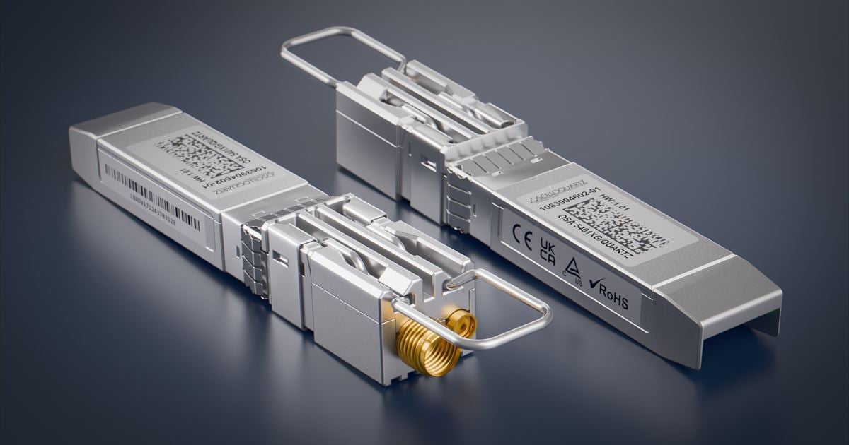
Adtran has launched the OSA 5401XG SyncPlug, an SFP-based grandmaster clock that delivers precise PTP and NTP synchronization for 10Gbit/s edge and access networks. The new Oscilloquartz device enables timing distribution through a compact, plug-in form factor that requires no rack space or complex installation, empowering network operators to extend synchronization into space- and power-limited deployments.
With multi-band GNSS support, compliance with PRTC‑B and compatibility with 10Gbit/s-only host platforms, it offers an efficient way to upgrade timing capabilities across sectors, including telecom, energy, defense, enterprise and more, according to Adtran.
“As networks evolve, precise timing has to reach further, faster and into more constrained environments. That’s exactly what the 5401XG SyncPlug is built for. It’s a no-compromise solution that fits directly into existing infrastructure, requires almost no space or power and delivers the performance needed for next-generation services,” said Gil Biran, GM of Oscilloquartz, Adtran. “By integrating advanced GNSS capabilities in a 10Gbit/s-ready SFP module, we’re giving our customers an easier, smarter way to deploy resilient timing, whether modernizing legacy sites, extending coverage at the edge or rolling out new, timing-critical applications.”
The OSA 5401XG SyncPlug is a fully featured SFP-based synchronization device that supports PTP grandmaster, boundary and slave clock modes, Stratum 1 NTP server functionality, and SyncE for frequency synchronization. It plugs directly into standard 1Gbit/s or 10Gbit/s ports and consumes less than 2.5W, making it ideal for space- and power-sensitive locations. With multi-band GNSS (L1 and L5), the device enables compliance with enhanced timing standards such as PRTC-B and supports regional systems, including India’s IRNSS. It also offers advanced spoofing and jamming detection, extended holdover and up to 500,000 NTP transactions per second, ensuring performance and security at scale.
“Demand for precise synchronization is growing rapidly across edge and access networks, and it has to be delivered with minimal footprint and maximum resilience,” commented Igal Pinhasov, VP of product line management at Oscilloquartz, Adtran. “From mobile backhaul and energy grids to secure government and business networks, the OSA 5401XG SyncPlug fits directly into existing infrastructure to deliver full grandmaster functionality over 10Gbit/s. There’s no need for extra cabling, appliances or rack space. It’s an ideal solution for operators looking to modernize timing in challenging environments while simplifying deployment and strengthening performance.”