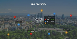
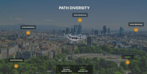
In December 2022, uAvionixannounced its updated product line for unmanned aerial systems (UAS) beyond visual line of sight (BVLOS) command and control (C2). The SkyLine C2 management platform and muLTElink airborne radio systems (ARS) are designed to integrate, which enables a self-healing C2 network capable of both path and link diversity. This eliminates lost-link possibilities over broad terrain and altitude ranges.
Image: uAvionixImage: uAvionix
MuLTElink ARS consists of two models — muLTElink915 and muLTElink5060, the core of the uAvionix C2 system. The muLTElink915 model combines globally licensed aviation LTE, enhanced with frequency hopping 902–928 MHz industrial, scientific and medical frequencies capability. The muLTElink5060 model combines global LTE with aviation-protected 5,030–5,091 MHz C-band for customers holding C-band licenses for control and non-payload communication (CNPC) operations.
Each muLTElink model allows up to one external CNPC radio to be optionally connected to allow simultaneous use of all three frequency ranges, higher power C-band operation or future radio integrations.
UAvionix updated its previous line of microLink and SkyLink ARS radios and relaunched them under the SkyLink ARS banner. Each SkyLink ARS can operate as a point-to-point radio or integrate with muLTElink and SkyLine for managed C2 operations. SkyLink915micro, formerly named microLink, offers a robust form factor and Lemo connector for UAS requiring hardened installations.
SkyLink5060micro and SkyLink5060 offer 100 mW and 10 W 5,030–5,091 MHz aviation protected C-band CNPC options.
Both platforms meet standards set by RTCA DO-362A and the U.S. Federal Aviation Administration’s draft Technical Standard Orders-C213a and may receive similar validated orders through other global aviation regulators.
Point One’s FusionEngine software, which is rated for automotive safety integrity level (ASIL), is now compatible with STMicroelectronics’ Teseo ASIL Precise Positioning GNSS chipset (TeseoAPP). This assures functional safety as ASIL-B, a requirement for Level 3+ advanced driver assistance systems (ADAS).
FusionEngine can be integrated into several different host processors that are used for enabling high level ADAS and autonomous driving systems. The combination of TeseoAPP’s receiver and the STA5365S external RF front-end provides dual-band measurement data for all visible GNSS satellites to the main host processor into which FusionEngine is integrated.
FusionEngine software is a precise location solution for automotive applications. For accuracy and to ensure the safety and integrity required for high level autonomous vehicles it combines data from multiple sensors, including the TeseoAPP multi-band GNSS receiver. It also enables developers to complete the functional safety concept phase for host system software integration.
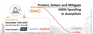
As drones are becoming a popular mode of delivery, surveillance, inspection, and mapping, they need to be resilient to spoofing. On Dec. 15, Septentrio hosted a webinar about detecting, mitigating, and protecting against spoofing on UAV autopilots.
Topics discussed included how GPS/GNSS technology fit into the autopilot ecosystem, signs of GPS spoofing and UAV vulnerabilities, realistic demonstrations of spoofing, how to mitigate spoofing, and autopilot compatibility with resilient GPS modules.
Wim De Wilde, R&D Team Leader at Septentrio, facilitated a presentation on vulnerabilities of UAVs. It included detecting signal anomalies and inconsistencies in GPS receivers to flag spoofing, technology used to spoof or hijack drones, and recommendations to prepare autopilots before take-off.
The next presentation, by Ramon Roche, General Manager at DroneCode Foundation and PX4 Autopilot, explained PX4 products that have built-in resilient GPS receivers. Greg Lopes, Hardware Design Engineer at Zipline, further elaborated about the importance of having robust, resilient GPS receivers to mitigate spoofing as it relates to Zipline’s delivery drones.
Figure 1
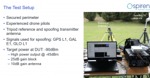
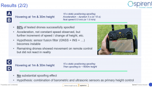
One of the final presentations was a case study of an in-field simulation and spoofing test by Jack Ackermann, Director of Product Line Management at Spirent. The case study preparation and test results that were discussed in the webinar can be seen in Figures 1 and 2.
Septentrio holds frequent webinars, with knowledgeable guest speakers, regarding topics related to GPS/GNSS technology. Find previous webinars and learn about upcoming ones here.
M3 Systems Belgium’s Haps-Augmented Search-And-Rescue Demonstrations System (HASARDS) project is looking to improve positioning of the global collaborative Copas-Sarsat search-and-rescue system by using its high-altitude platform system (HAPS).
The project is designing features for the system, such as carrying out geolocation with HAPS imagery and establishing communication between individuals in distress and emergency services.
While conducting HASARD, researchers were able to document system enhancements, execute a piloted flight-test campaign to create a realistic distressed aircraft carrying a second-generation beacon and future HAPS, and develop and operate a second-generation beacon signal simulator and HAPS system simulator.
Researchers found that using HAPS independent of Cospas-Sarsat adds value to search-and-rescue operations, providing location details via data fusion and georeferenced imagery while relaying communication between SAR teams and people in distress.
Advanced Navigation, a developer of AI robotics and navigation technology, has raised $68 million in a Series B funding round. The Series B round was led by global investment firm KKR.
The funding round includes participation from new investors such as deep learning venture firm AI Capital and existing investors, including Main Sequence, the Hon. Malcolm Turnbull AC, In-Q-Tel, and Our Innovation Fund, bringing Advanced Navigation’s total amount raised to more than $85 million.
Advanced Navigation supplies solutions to some of the world’s largest tech companies, such as Fugro, NASA, Tesla, Google and Boeing. The funding will be used to develop AI technologies and expand autonomy beyond its current scope, including solutions to help guide driverless vehicles, flying taxis, space crafts, drone deliveries, autonomous farming and deep sea robotics. The company will also assess inorganic growth opportunities to incorporate new technologies and products into its suite which complement the company’s existing products and areas of expertise.
Louis Casey, KKR’s growth technology lead in Australia, New Zealand, and Southeast Asia, said, “Advances in autonomous navigation technology that leverages AI to reduce sensor cost while improving performance can rapidly increase enterprise and consumer applications globally. We are very pleased to work alongside the Advanced Navigation team to support the company’s growth.”
In addition, Louis Casey and Vance Serchuk, Executive Director of the KKR Global Institute, will join Advanced Navigation’s board of directors. General David Petraeus (U.S. Army, Ret.), Partner, KKR and Chairman of the KKR Global Institute, will chair a new advisory committee that targets to support the company’s global expansion efforts.
The BLK2FLY, recognized for its productivity and innovation, is a fully integrated autonomous flying laser scanner. It’s part of Hexagon’s BLK suite of autonomous reality capture sensors designed for speed, portability, ease-of-use and mobility.
To compile the list, TIME solicited nominations from TIME’s editors and correspondents around the world, and through an online application process, paying special attention to growing fields — such as the electric vehicle industry, green energy and the metaverse. TIME then evaluated each contender on key factors including originality, efficacy, ambition and impact.
“Having our reality capture technology recognized by TIME as one of the year’s best inventions is both humbling and inspiring. It validates our mission to build Smart Digital Realities that empower an autonomous, sustainable future,” said Hexagon President and CEO Ola Rollén. “Our technologies aim to change the world for the better, turning concepts that were once thought impossible into real solutions that benefit everyone. By optimizing quality, productivity, efficiency and safety — profitably — we can help industry achieve sustainability through mitigated risk, less waste and reduced cost.”
As a lidar-based unmanned aerial vehicle (UAV), the BLK2FLY addresses costly and complex issues, quickly and accurately capturing everything from large outdoor spaces to complex structures and environments.
For example, when renovating building structures, it can easily capture the exterior dimensions of previously inaccessible or difficult-to-reach areas such as rooftops and facades. The resulting colorized 3D point clouds are instrumental in building information modeling (BIM) processes, documenting site conditions and improving an asset’s operation, from infrastructure to utilities to industrial facilities.
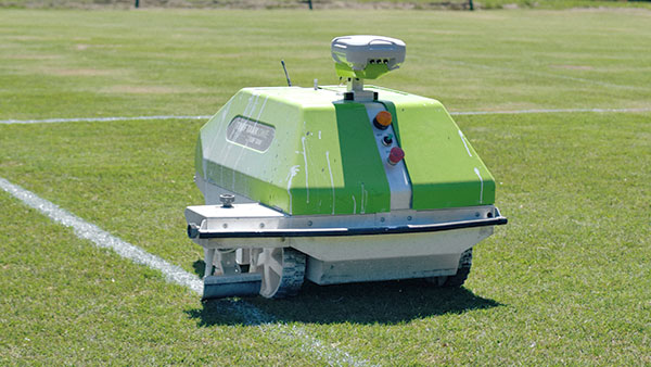
Turf Tank is an autonomous, GNSS-guided line-marking robot built specifically to paint lines on athletic fields.
More than 550 Turf Tank robots are deployed across the United States, painting athletic fields at public schools, major colleges and universities, amateur and professional soccer clubs, local parks and recreation departments, and a two National Football League stadiums.
The Turf Tank robots can paint a full soccer field in less than 30 minutes, compared to two or three hours for manual painting. Similarly, the robot can paint a football field in two or three hours compared to eight to 10 hours to paint a football field.
The robots are eco-friendly — they’re powered by rechargeable batteries and use far less paint than most older paint machines.
The portable drone has an RTK module for centimeter-level precision and a 56× zoom camera
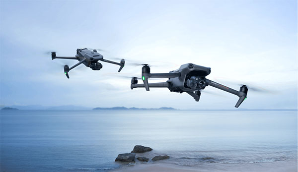
DJI has launched its Mavic 3 Enterprise Series, designed for business, government, education and public safety.
The DJI Mavic 3E and DJI Mavic 3T are compact drones designed to provide professional users with safe and efficient aerial technology. Both drones are based on DJI’s flagship Mavic 3 series and have been designed to operate in a vast array of commercial missions.
Portable and compact, the drones can be carried in one hand and deployed at a moment’s notice. Flight time is 45 minutes.
Surveying tools. Both models have a real-time kinematic (RTK) module that enables surveying professionals to achieve centimeter-level accuracy with support for network RTK, custom network RTK services, and the D-RTK 2 Mobile Station.
The D-RTK 2 Mobile Station is DJI’s upgraded high-precision GNSS receiver that supports all major global satellite navigation systems, providing real-time differential corrections.
Safety Features. The Mavic 3 Enterprise series has improved obstacle sensing and navigation systems, including DJI AirSense, which receives ADS-B signals from traditional aircraft in the area to warn drone pilots of other air traffic nearby. The new improved DJI APAS system 5.0 for obstacle sensing with zero blind spots is supported by six omnidirectional fish-eye sensors.
Cameras equipped. It integrates a 20-MP wide-angle camera with a 4/3 CMOS sensor with large 3.3 μm pixels that, together with Intelligent Low-Light Mode, offer significantly improved performance in dim conditions. Its powerful up-to-56x hybrid zoom camera has an equivalent focal length of 162mm for 12MP images. A mechanical shutter prevents motion blur and supports rapid 0.7-second interval shooting.
Photo: DJI
The DJI Mavic 3E enables efficient mapping and surveying missions without the need for ground control points. Other fields that could use the drone include environmental and wildlife protection, construction, surveying, energy and public safety.
The DJI Mavic 3T is engineered for aerial operations in firefighting, search and rescue, inspections and night missions. It has the same tele camera as Mavic 3E, a 48 MP camera with a 1/2” CMOS sensor, and a thermal camera with a Display Field of View (DFOV) of 61° and an equivalent focal length of 40mm with 640 × 512 px resolution.
The Mavic 3T’s thermal camera supports point and area temperature measurement, high temperature alerts, color palettes, and isotherms to help professionals find hot spots and make quick decisions. With a simultaneous split-screen zoom, the Mavic 3T’s thermal and zoom cameras support 28× continuous side-by-side digital zoom for easy comparisons.
Image transmission. With a maximum control range of 15 km, DJI O3 Enterprise Transmission enables the Mavic 3 Enterprise drones to fly further and transmit signals with higher stability, offering pilots greater peace of mind during flight. It provides a high frame rate live feed at 1080p/30 fps.
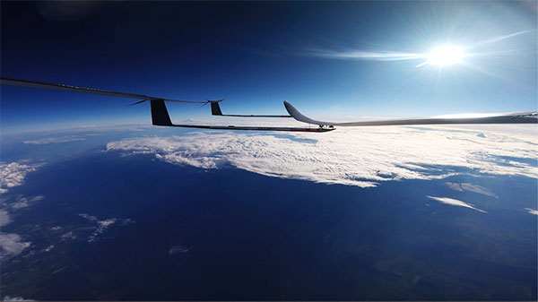
UAVOS has completed a successful test flight of the ApusDuo solar-powered high-altitude platform system (HAPS). The test flight, at a European Flight Center, was conducted continuously for 11 hours and reached altitudes of 15,000 meters.
The ApusDuo successfully achieved more than two dozen test points, including energy balance validation, power and propulsion performance, and propeller revolutions per minute evaluation. The team also tested aircraft motor control efficiency, which was refined following previous test flights.
After operations in Europe, UAVOS plans to transport ApusDuo to Argentina. The company is accelerating preparations to perform the next phase of test flights in the stratosphere.
ApusDuo is a stratospheric UAV running on solar power, and is meant to provide persistent local satellite-like services. Built with carbon-fiber composites, it can be landed, re-equipped with multitask payloads and re-deployed. It is also capable of flying autonomously from takeoff to landing and can be remotely operated from its ground-control station.
The flight test is the third of several to simulate a variety of real-world scenarios that demonstrate how UTM and ATM intersect with multiple aircraft types.
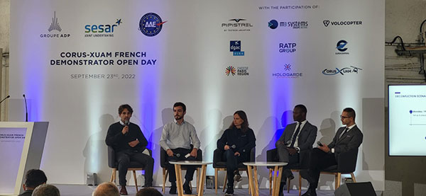
M3 Systems, Pipistrel and Volocopter have completed their first joint flight test campaign in France at Pontoise airfield.
The week-long flight tests simulated three different avoidance maneuvers in real-world situations where unforeseen circumstances occur, such as a complete airport or vertiport closure, an unavailable final approach and takeoff area, and traffic deconfliction.
M3 Systems was created from engineering activities in GNSS and consulting activities in air traffic management (ATM), including for uncrewed aircraft. M3 played a role in Galileo signal definition, among other projects for Europe’s various space agencies. Pipstrel is a light aircraft manufacturer specializing in electric propulsion, and Volocopter specializes in urban air mobility (UAM) systems.
The joint campaign among the three companies — with French partners Groupe ADP and its subsidiary Hologarde — aimed to achieve smooth interaction within and between the new lower airspace’s unmanned traffic management (UTM) and standard civil aviation ATM systems.
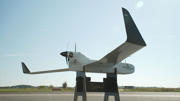
The Boreal system is a fixed-wing UAV with high-endurance and heavy payload capacity. (Photo: M3 Systems)
The aviation industry is experiencing an innovation upsurge driven by technology and societal pressure for new forms of aviation focused on sustainable, digital and autonomous air mobility. The resulting solutions will generate a significant increase in traffic density in the lower airspace.
Because existing ATM systems are not designed to handle such volumes or digitalization, coordinating existing and new traffic management systems for brand-new aircraft integration will ensure efficient large-scale operations. This includes commercial, general and drone aircraft for cargo and passenger flights, both crewed and uncrewed.
The CORUS-XUAM project, funded by the European Union’s initiative Single European Sky ATM Research (SESAR) Joint Undertaking, focuses on solving the challenge of conventional and new traffic management system integration and consists of 19 partners and 11 third parties. M3 Systems, Pipistrel and Volocopter all completed individual flight-test campaigns before this event to bring their aircraft in line with the U-space services.
A week of flight tests ended with an Open Day air show and presentations. (Photo: M3 Mobility)
The CORUS-XUAM flight test conducted at Pontoise airfield near Paris is the third of several flight tests to simulate a variety of real-world scenarios that demonstrate how UTM and ATM intersect with multiple aircraft types.
Moreover, the CORUS-XUAM project will continue to proactively test and create a safe and controlled lower airspace under the European Union’s ambitious Single European Sky (SES) initiative throughout 2022.
The successful flight tests at Pontoise airfield were conducted with M3 System’s Boreal remotely piloted aircraft system, Pipistrel’s crewed Velis Electro, the only type-certified electric aircraft in commercial service in the world, and Volocopter’s fullscale, remotely piloted 2X prototype. Pipistrel uses the conventional ATM tower and system while Volocopter and M3 Systems use the UTM system. The following three flight scenarios were tested:
The unexpected occupancy of a final-approach-and-takeoff plan and aircraft diversion because of priority landing of another aircraft (Pipistrel and Volocopter aircraft).
The diversion of a flight path because of the closure of an airport or vertiport (M3 Systems).
The diversion of a flight path with two aircraft flying the same path (M3 Systems and Volocopter aircraft).
“These successful tests confirm that our Boreal UAS will be an enabler for future XUAM operations in situations where aircraft need to safely divert paths to another vertiport due to an unforeseen closure or another aircraft in the air,” explained Marc Pollina, M3 Systems CEO. “By providing rerouting demonstrations and tactical communications with U-Space service providers, M3 Systems can support future coordination between AAM and airport operators.”
Pipistrel is “As the manufacturer of the only type-certified electric aircraft in commercial service in the world, proud to take part in technical projects that shape the vision of air mobility and make progress in a meaningful way,” said Gabriel Massey, Pipistrel president. “The CORUS project and Paris demonstrations clearly show how UAM vehicles will be able to fly safely in regular airspace post-2030 and will help to unlock new lower-noise and lower-emission air passenger and air cargo services.”
In 2019, Volocopter tested its 2X ATM integration at Helsinki airport and was actively involved in the development of the European U-Space Concept of Operations, according to Oliver Reinhardt, Volocopter’s chief risk and certification officer. “Building an efficient ecosystem around UAM is Volocopter’s mission, and connecting ATM/UTM integration with our digital platform, VoloIQ, is poised to be an integral part of bringing UAM to megacities worldwide,” Reinhardt said. “I am looking forward to the next CORUS-XUAM test flights later this year in Germany and what we can achieve there.”
The project has received funding from the SESAR Joint Undertaking under the European Union’s Horizon 2020 research and innovation program under grant agreement No. 101017682.
AUVSI’s effort is designed to expand the number of vetted uncrewed aircraft systems (UAS) that meet congressional and federal agency drone security requirements.
DIU accelerates commercial technology for national security. Its Blue UAS program launched in 2021 is aimed at prototyping and scaling capable and secure commercial UAS technology for the Department of Defense (DOD).
“The goal of this new pilot initiative is to extend relevant cyber credentialing across the U.S. industrial base, proactively, streamlining and accelerating capabilities available to the DOD and the rest of the U.S. government,” said Brian Wynne, AUVSI president and CEO. “We are grateful for DIU’s partnership and look forward to working with them to make the U.S. drone industry more resilient and secure.”
AUVSI efforts will streamline the vetting process and expand potential small UAS entrants to the government through its Trusted Cyber Program. The industry-led cyber compliance effort will work with a suite of cybersecurity firms to provide technical cyber assessments. DIU, DOD and other government organizations can then conduct additional vetting if needed.
The Blue UAS program has helped establish a cybersecurity baseline and coordinate government efforts to streamline the approval process for commercially available NDAA-compliant drones. Thirteen drones are scheduled to be added to the Blue UAS Cleared List, but demand for additional cleared drones with new capabilities has outpaced DIU’s ability to scale this critical program, because of limited funding and manpower. Because of its unique position in the market, AUVSI and its Trusted Cyber Program will provide this cybersecurity certification pathway to the commercial industry in close coordination with DIU.
“Commercial-off-the-shelf UAS are increasingly relied upon by federal agencies as critical tools to conduct diverse operations,” said David Michelson, DIU program manager for Blue UAS. “Partnerships with industry that make it easier for federal users to access commercial technology will help achieve the program’s goals.”
Funding continues to flow into companies developing and testing electric vertical-takeoff-and-landing (eVTOL) drones — both piloted and unpiloted.Plus, the potential for clearing landmines using drones is being investigated by a team at Oklahoma State University.
Air taxis advance with funding
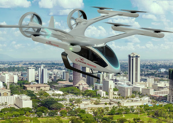
In early September, United Airlines committed to a $15 million investment in Eve Air Mobility, giving the air taxi industry another shot in the arm. The deal includes a conditional purchase of 200 and an additional 200 in options for Eve’s semi-autonomous four-passenger eVTOL aircraft. The investment is one of United’s efforts toward its goal of net zero carbon emissions by 2050.
Eve Air Mobility is partnered with Embraer, the Brazilian aircraft manufacturer guiding Eve’s path to first eVTOL aircraft certification under the National Civil Aviation Agency of Brazil (ANAC). Subsequent approval by the U.S. Federal Aviation Administration (FAA) and the European Union Aviation Safety Agency (EASA) would then be based on the Brazilian ANAC certification program, following in the path of U.S. and European approvals of the Embraer EMB/ERJ series of passenger aircraft.
The Eve eVTOL air taxi. (Image: Eve Air Mobility)
Eve and parent Embraer also have announced a deal with BAE Systems to design an eVTOL aircraft for military and security applications. The technical details of the UAV/aircraft have been kept carefully under wraps, save for the visible use of eight lift rotors and two ducted fans for forward flight. Flight management computers, guidance, air-data, altitude sensors and high-integrity communications would likely be included in the avionics suite.
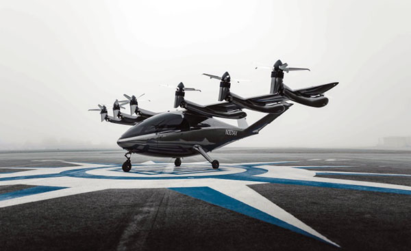
Meanwhile, United’s prior investment in Archer Aviation and its Maker eVTOL appears to be supporting the Maker’s progress along the road to civil certification. Maker flight tests so far have apparently been limited to vertical flight; its multiple lift and tilt-rotor design has yet to be tested in transition to forward flight.
The Maker eVTOL air taxi. (Image: Archer Aviation)
Nevertheless, more information appears to be available on the configuration of the Maker eVTOL. The company’s approach is to demonstrate early on that safety is a major driver for the design, with significant redundancy in the vehicle’s systems. The Maker has four flight-control computers, plus redundant control and navigation with inertial navigation, GNSS and above-ground-level (AGL) sensors, both radar and laser altimeters. Redundant communication links between sensors, flight-control computers and actuators combine to provide another level of design safety. The vehicle has six lift rotors at the back of the wing, plus an additional six main tilt-rotor lift and thrust rotors — another significant contribution to redundancy.
In January 2021, Archer said that United Airlines ordered 200 Maker aircraft for $1 billion with an option for more aircraft worth $500 million. Archer also just got another healthy financial injection in August with United’s pre-delivery commitment of $10 million for 100 Maker-type aircraft.
There are numerous eVTOL builders around the world. Several of note include Boeing/Wisk (U.S. and New Zealand), Joby (U.S.), Vertical Aerospace (UK), Ehang (China), Airbus (France), Lilium and Velocopter (both Germany) and Beta (U.S.).
Drones help detect landmines
Its difficult to imagine the extent of the problem, but there are many, many areas of the world where landmines are a major hazard to civilian life. Eventually, wars move on or die out, with not only towns and infrastructure destroyed, but significant left-over hazards to reclaiming territory once occupied by the aggressors.
Landmines come in many flavors, but most are deadly and most kill or maim innocent people coming across them. Unexploded bombs, mortar shells and the like also can kill and hurt people, especially children. Apparently, 50 to 60 countries around the world have areas where landmines or unexploded ordnance pose a threat to civilians.
The good news is that several organizations around the world have been using drones to survey areas suspected of being mined. The organizations send drones equipped with magnetic detection sensors a few inches above the ground. The drones geotag mine locations, and those locations go into an area database. Then another drone is sent to drop a detonator on the mine location, with the mine later exploded from a distance.
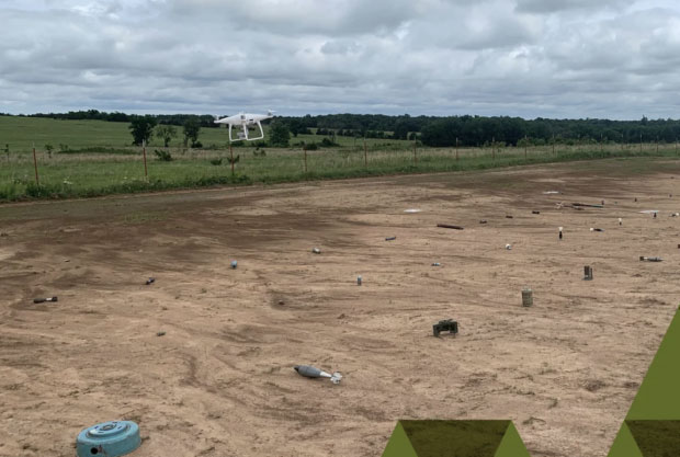
An investigative team at Oklahoma State University is making an effort to train a drone-based machine-learning system to recognize various types of landmines and explosive ordinance. While the system isn’t aimed at detecting mines without human participation, it’s expected that drone recognition of mines could greatly improve current efforts to remove landmines, and quicken the pace at which the world can get rid of this plague of hidden explosives.
A drone flies over a grid showing 50 types of ordinance. (Photo: Oklahoma State University)
The research team is working in an area they have set up with inert mines of many types to train the drones to recognize the specific type of device and geotag the location. This isn’t artificial intelligence as such; it’s using drones to find an object and geotag it, while the network to which the drone is connected recognizes from the sensor data what type of mine the drone has found.
In the research phase, the team is feeding data into the network on lots of different types of mines and munitions, providing the network with a model for each type of ordinance and eventually enabling device recognition in the field.
To sum up, the rush for air taxis to become a ubiquitous resource for city travel still wends its way through the civilian twists and turns leading to civilian certification for use, with many outfits working hard to build flying testbeds and investors funding their efforts.
Finding novel drone-assisted ways to clear the millions of landmines left over in wartorn countries is becoming a higher priority — notwithstanding Princess Diana’s efforts to draw attention to the suffering and death from landmines several decades ago. Let’s hope this goes somewhere soon.