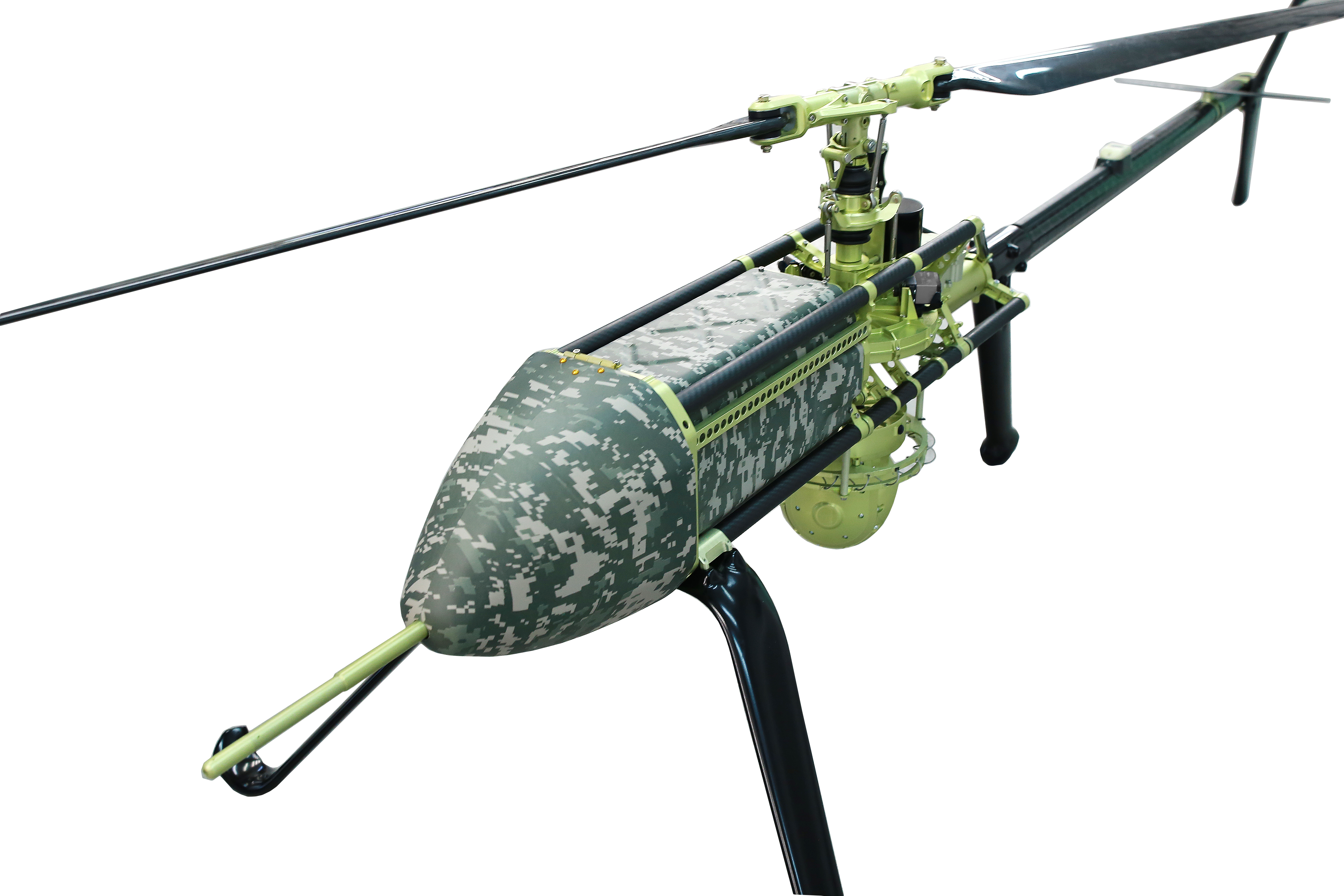
UAVOS has been selected by Bayanat, a provider of artificial intelligence-powered geospatial solutions, to deliver its unmanned aircraft system (UAS) for a variety of applications, including aerial photography and perimeter control. The UAS consists of two UVH 25EL unmanned autonomous helicopters powered by electric motors, a ground control station, and various sensor payloads — including a multispectral camera, lidar, and digital and thermal cameras.
The autonomous helicopter’s advanced capabilities of long endurance — up to 1.5-hours — along with its camera capabilities, enable the UVH 25EL to carry out accurate mapping within a radius of 67 km.
The UVH 25EL has a practical load weight of 5 kg. These capabilities enable high performance as well as maximum operational flexibility for applications such as coastal security, search and rescue, and advanced aerial photography missions.
UAVOS also provides full operational support, including training, and a fundamental review of the UAS’s possible uses.
XTEND has acquired Performance Rotors, a Singapore-based UAV inspection company. This acquisition will improve XTEND’s ability to offer human-guided, remote interactive operations in a range of inspection scenarios.
“Performance Rotors’ mission has always been to develop UAVs and robotics solutions for data acquisition in GPS-denied and confined space environments, without the risk to human lives,” Keith Ng, co-founder and CEO of Performance Rotors, said. “We are confident that combining XTEND’s innovation XOS software with our world-class technology brings the best of the industry together in one powerful and easy to use solution that comprehensively addresses the critical challenges facing our customers today.”
XTEND provides human-guided autonomous machine systems that enable operators to perform accurate maneuvers and actions in any environment with minimal training. Its XOS operating system enables practical autonomy allowing professionals to control UAVs and smart machines that carry out complex tasks that require human interaction and decision-making safely and remotely.
Percepto has received a waiver from the Federal Aviation Administration (FAA) that allows it to operate unmanned aerial systems (UAS) beyond visual line of sight (BVLOS) in shielded airspace — without humans onsite, and without ground-based or airborne detect and avoid (DAA) systems — for inspection and monitoring operations at critical and non-critical infrastructure sites nationwide.
Under the waiver, low risk “shielded” BVLOS operations are authorized 200 ft above and around assets located on critical infrastructure sites. At non-critical infrastructure sites, shielded BVLOS operations are permitted 50 ft above and around the height of the tallest obstruction located within a half-mile radius of the site.
The operations authorized under this approval build upon recommendations made by the UAS BVLOS Aviation Rulemaking Committee chartered by the FAA. The ARC recognized that shielded airspace near structures and other obstacles where crewed aircraft do not typically operate could be leveraged as a safety mitigation to support safe, scalable, and economically viable UAS BVLOS operations.
The use of Percepto’s UAS to perform critical infrastructure inspections aims to improve worker safety and efficiency of operations by enabling inspections remotely from anywhere in the United States.
Percepto is at XPONENTIAL May 9-11, at booth 3409.
FlightOps is collaborating with Qualcomm Technologies to develop UAV automation technology designed specifically for first responders. FlightOps has integrated its advanced UAV automation technology onto the Qualcomm Robotics RB5 platform — which has 5G connectivity, on-device artificial intelligence, and heterogeneous computing capabilities.
The integration of FlightOps’ technology onto the Qualcomm Robotics RB5 will enable the platform to automate critical tasks such as flight planning, monitoring and data collection, enabling first responders to focus on the mission at hand.
The technology is being showcased during XPONENTIAL May 9-11. FlightOps is at booth 4041.
The live remote flights, operated from Denver and flown in San Diego, will demonstrate the capabilities of the integrated product and how it can be used to improve response times as well as enhance situational awareness during emergencies.
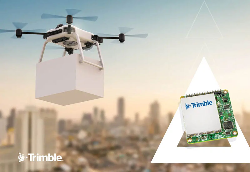
Trimble has released the PX-1 RTX for accurate and robust positioning and heading for commercial UAV delivery applications. This positioning solution enables UAV integration companies to add precise positioning capabilities so that operators can plan and execute takeoff, navigation and landing tasks as UAV delivery advances to take on more challenging operations.
The PX-1 RTX leverages Trimble’s CenterPoint RTX corrections and small, high-performance GNSS-inertial hardware to provide real-time, centimeter-level positioning and accurate inertial-derived true heading measurements. This solution allows operators precise control of UAVs during takeoff and landing to tackle more demanding operations in tight or partially obstructed spaces.
It also minimizes operational risks from poor sensor performance or magnetic interference by ensuring greater positioning redundancy, which is especially important as commercial UAV delivery operations venture into difficult urban and suburban environments.
The Trimble PX-1 RTX solution is available through Trimble Applanix sales channels. For more information click here.
The launch will be held at XPONENTIAL. Visit Trimble at Booth 1806 to learn more.
On May 3, Russia claimed Ukraine had launched an overnight UAV attack on the Kremlin in an effort to assassinate President Vladimir Putin, reported multiple news sources including NBC News and Reuters. President Volodymyr Zelenskiy quickly denied any Ukrainian involvement.
A video taken of the incident posted on social media shows two UAVs aimed at the Kremlin that were promptly shot down.
A Ukrainian official stated the incident suggested Moscow was preparing a major terrorist provocation, reported Reuters. Putin’s office said Russia reserved the right to retaliate and that it regards the incident as a planned act of terrorism and an attempt on the president’s life.
A Russian agency also stated Putin was not at the Kremlin at the time of the incident.
BREAKING: Footage surfaces of Ukrainian drone strike on the Kremlin last night. Russian govt confirms 2 unmanned aircraft downed by electronic-warfare systems after crashing into the Kremlin. Tensions escalate amid #UkraineRussiaWar️, inching closer to WW3. #KremlinStrike… pic.twitter.com/RdOHmcsh5k
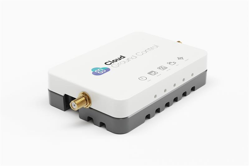
Credit: Cloud Ground Control by Advanced Navigation
Cloud Ground Control, an Advanced Navigation company, has released its cellular micro-modem, the CGConnect. Using 4G/5G networks, CGConnect links UAVs or robotic vehicles to Cloud Ground Control’s cloud-based UAV fleet management platform — enabling live-streaming, command and control from a web browser.
CGConnect can securely connect UAVs and vehicles into one autonomous fleet across land, sea and air, regardless of manufacturer or model. This provides mission planners and operators with full situational awareness for search and rescue, emergency response and disaster relief.
Artificial intelligence (AI) algorithms run in the cloud, relaying real-time camera feed data to the end user to support missions such as object detection, tracking and thermal imaging. The flexible and customizable open platform operates on industry standards, which multiplies potential product applications and enables autonomous vehicles and payloads to operate as a coordinated fleet.
CGConnect’s high-grade security safeguards data and IP from vulnerabilities and security breaches, helping users meet compliance obligations. Additionally, CGConnect supports edge AI to perform intensive object identification and classification directly on the vehicle for dynamic missions.
CGConnect is available for pre-order. An OEM option is also available.
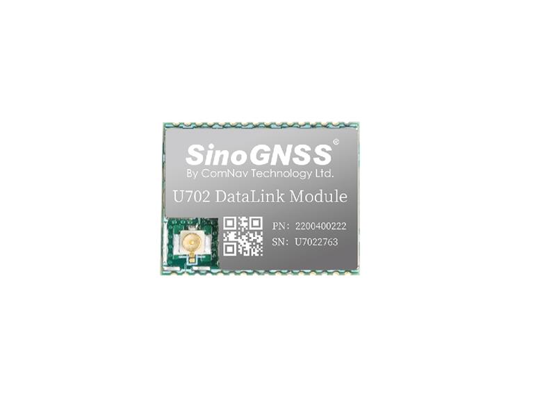
Comnav Technology has released the U702 datalink module, an RX/TX data link module that supports the LoRa modulation technique.
Its compact, surface-mounted design and robust electromagnetic compatibility enables easy integration into GNSS systems such as robotic lawn mowers.
With the LoRa modulation technique, the U702 has low power consumption, reception power of 0.025 w, and a working distance up to 1.5 km. It also enhances the ability to protect GNSS systems against various interference — making it possible to have high reception sensitivity, a low error rate, and high reliable data transmission even in harsh environments.
Trimble has partnered with Nissan Motor Company to use Trimble’ RTX network as the positioning source to enhance the capabilities of the ProPILOT Assist 2.0 driver assistance system in Nissan vehicles.
The Trimble RTX network is supported by a globally redundant and resilient infrastructure and is backed by a team of ISO 20,000 certified network engineers and IT specialists, which monitor operations to ensure optimal signal performance and reliability for drivers. Trimble’s RTX positioning technology can provide decimeter-level accuracy in seconds, making it suitable for autonomy applications, including automotive driving.
The ProPILOT 2.0 Assist system enables hands-off driving while cruising in a single lane and when the vehicle approaches a road divide. When the car is passing a slower vehicle, the system judges the appropriate timing of branching off or passing based on information from the navigation system and 360-degree sensing.
The ProPILOT 2.0 Assist system with Trimble’s RTX network will be initially available on the 2023 Nissan Ariya.
“Seen & Heard” is a monthly feature of GPS World magazine, traveling the world to capture interesting and unusual news stories involving the GNSS/PNT industry.
Image: BanksPhotos/E+/Getty Images
Dozens Stranded in Tundra
Several vehicles in Rock Springs, Wyoming, were stranded after being led by their map apps or vehicle navigation systems to an unmaintained county road in a blizzard. Several calls were made to the Sweetwater County Sheriff’s Office about stranded vehicles stuck after they were directed to the detour when Interstate 80 was closed due to winter conditions. Similar incidents were reported by other counties, resulting in discussions between the Wyoming Department of Transportation and the companies that develop navigation software.
Screenshot: CBS video
UAVs contain Western Technology
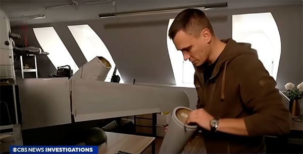
A Ukrainian intelligence assessment obtained by CNN and CBS reported an Iranian UAV downed in Ukraine contained technology from companies in the United States and other western countries. The White House has since launched an investigation as to how the technology — including semiconductors, GPS modules and engines — were obtained by Iran. The components removed from an Iranian Shahed-136 UAV totaled 52, 40 of which were manufactured by 13 different U.S. companies. The remaining components were manufactured by other western companies and by companies based in Japan, Taiwan and China.
Researchers may now be able to monitor climate-induced natural hazards by combining satellite technology with machine learning. Researchers were able to use machine learning to study hurricanes that made landfall over the Gulf of Mexico in a series of recent experiments. C.K. Shum, the co-author of the study and a professor at the Byrd Polar Research Center, uses geodesy to study global climate change phenomena. Using geodetic data gathered from satellites, Shum tested whether a mix of remote sensing and machine learning analytics could accurately monitor weather phenomena. Accurate measurements could help improve hurricane forecasting.
Sailboat. (Image: valio84sl/iStock / Getty)
The power of TikTok is real
TikTok changed Jeff Foulk’s life when his daughter posted about his free marine navigation app, Argo, when they attended a boat show in Chicago. Foulk was promoting Argo with little success, until his daughter shared with the social media platform his struggle as the owner of a small business. Since then, the app has been downloaded more than 200,000 times and remains at the top of the charts for boat navigation apps. Argo was launched more than four years ago and, until now, had only 100,000 total downloads. Now that Argo is viral, Foulk wants to launch a premium subscription.
Another autonomous lawn mower has hit the field. The RoboUp (made by a company of the same name) is offering a no-perimeter-wire real-time kinematic (RTK) artificial intelligence (AI) robot lawn mower.
The mower uses an RTK module built into the charging station and AI real-time recognition support to automatically measure and profile a yard without any perimeter wiring or other installation.
RoboUp’s dynamic exact positioning system integrates RTK, visual simultaneous localization and mapping (SLAM) and an inertial measurement unit (IMU) to offer precise positioning with centimeter-level accuracy. It can also detect boundaries and identify obstacles and will stop cutting when it reaches either.
The robot lawn mower is powered by a maintenance-free brushless motor, which enables it to climb a 45% slope and cut different types of lawns, including over tough terrain. RoboUP is equipped with adjustable cutting heights of 30 mm to 60 mm and 20 cm width and can adjust the height of the cutting disc to match the terrain.
The mower can be controlled with its own app, which identifies the conditions of the user’s yard and generates a recommended cutting schedule. Additionally, it integrates with smart home systems and can be controlled by voice commands.
uAvionix has received approval by the Federal Aviation Administration (FAA) to conduct beyond-visual-line-of-sight (BVLOS) small unmanned aerial flight in North Dakota. The test flight to secure approval took place at the Northern Plains UAS Test Site in North Dakota.
Vantis is North Dakota’s UAS network, which serves many UAS operators across different sectors. By leveraging Vantis, uAvionix demonstrated to the FAA it had established adequate risk mitigations to satisfy required safety standards for BVLOS operation within the national airspace system.
The Northern Plains UAS Test Site partnered with Thales USA to develop and implement Vantis. The UAS system enables UAS pilots to command and control the UAS and remain clear of other aircraft when flying BVLOS. Vantis includes ground-based aviation infrastructure, which lowers the barrier of entry to BVLOS flights for multiple users.
The FAA approval to conduct BVLOS UAS flights is another step in bringing UAS to commercial sectors. UAvionix continues to collaborate with FAA as regulations evolve to ensure Vantis meets all necessary requirements.