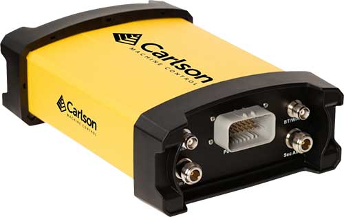
Carlson Machine Control has introduced the Vsx7 multi-frequency position and heading receiver. The Vsx7 is a multi-GNSS receiver designed specifically for machine control and can be installed on excavators, drills, pile drivers and more.
Paired with the Carlson A45 antennas, the Vsx7 features high-precision positioning in Athena RTK, Atlas L-band and SBAS and heading accuracy of up to .01 degrees. The whole Vsx7 system is designed to operate in harsh conditions from -40 degrees Fahrenheit to 158 degrees Fahrenheit. It can be mounted either by bolts or with magnets depending on the application and external environment.
The Vsx7 is primarily used in the mining and construction industries but can be adopted into similar industries with its companion software, Carlson Grade. Field data can be collected and viewed in real-time both at the machine with either, the MC8 or MC10 control box as well as in the office with Carlson Command.
“Our customers are able to operate day after day with complete confidence in their machine guidance,” says Tim Jones, director of Machine Control. “The Vsx7 is a perfect form factor for our customers and to Carlson Grade and Carlson Command as a ruggedized GNSS receiver.”
Carlson Grade is a machine guidance software solution that can be adapted to any heavy machine for grading, excavating, mining, shoveling, drilling, pile driving and landfill operation. Carlson Grade provides real-time field reporting and allows operators to view where they are in the project and at all times.
Carlson Command is a site management software solution that provides multiple viewing options of multiple and single machines in real-time. Command allows machine positions to be viewed as well as cut/fill and elevation. Managers can also remote into machines and transmit messages directly to an operator.
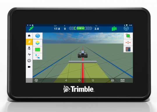
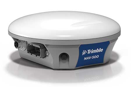
Trimble has introduced the GFX-350 display and NAV-500 guidance controller, providing a cost-effective option for farmers seeking to adopt the latest precision agriculture technology for their daily operations.
The GFX-500 display. (Photo: Trimble)
The GFX-350 Android-based touchscreen is a cost-effective way to introduce auto-steering and application control to the farm. The 7-inch (18-centimeter) screen is easy to read and can be used to control most field operations with a few taps.
The display is compatible with both the NAV-500 and the NAV-900 guidance controllers, satisfying different user accuracy needs. The simple and intuitive Precision-IQ operating system speeds up field work and makes equipment configuration a breeze. Once vehicles, fields, implements and materials are set up during the first use, they are saved and can be re-used with a couple of clicks.
The NAV-500 controller. (Photo: Trimble)
In addition, the GFX-350 display is fully ISOBUS compatible, offering plug-and-play capability for ISO-enabled implements with native task controller and universal terminal functionality. The display also features onboard Wi-Fi and Bluetooth connectivity, allowing seamless sharing of data between the office and the field via optional Trimble Connected Farm solutions. General record keeping and proof of placement reporting has never been easier.
The NAV-500 guidance controller features a low-profile rugged housing capable of receiving signals from five different GNSS satellite constellations — GPS, Galileo, GLONASS, BeiDou and QZSS. This precision solution offers sub-meter repeatable accuracy and full-farm coverage ideal for tillage, broad-acre seeding, spraying and harvest operations.
By using Trimble’s ViewPoint RTX satellite-delivered correction service with the NAV-500, operators can consistently achieve 15 centimeter pass-to-pass accuracy. Paired with either the new GFX-350 display or larger 10-inch (25.4-centimeter) GFX-750 display, the NAV-500 can provide roll-corrected manual guidance or can automatically control steering with the EZ-Steer assisted steering system and EZ-Pilot® Pro steering system.
“Connectivity and interoperability are very important to the future of agriculture and Trimble has made these features a cornerstone of our product portfolio,” said Abe Hughes, general manager of Trimble’s Agriculture Division. “Customers can select from a range of hardware and software options to meet their specific needs and budget. And the true beauty of this flexible product integration is that it can grow with the farmer’s operation. Upgrades can be as simple as moving to a higher precision correction signal or using existing mounts to install a larger and more capable receiver or display. Ease of installation and operation are key with the GFX-350, which can reduce barriers to entry for farmers new to precision agriculture.”
The GFX-350 display and NAV-500 guidance controller are designed for clean and simple installation that can typically be completed in half a day, getting farming equipment back in the field faster. The display uses a quick release RAM mount for easy transfer between vehicles, and typically requires only two cables to be attached, reducing clutter in the cab.
Trimble’s GFX-350 display and NAV-500 guidance controller are expected to be available for order in the fourth quarter 2019 from the Trimble dealer and Vantage distribution networks.
The precision farming market is set to grow from its current market value of more than $4 billion to more than $12 billion by 2025, as reported in the latest study by Global Market Insights, Inc.
The market growth is attributed to the rising adoption of smart agricultural practices to increase productivity. The use of Big Data along with information and communication technologies will provide farmers with more accurate insights into the existing crop conditions.
Another factor contributing to the precision farming market growth is the popularity of drones and IoT for greater production capabilities and analytics. The IoT plays a substantial role in increasing productivity and providing insights about the recent trends of crops. The technology provides an interconnected and multidimensional view of farming activities and offers actionable insights about the environment.
The government agencies worldwide are making efforts to spur innovations in the agriculture sector. For instance, in 2017, the Dutch government invested USD 1.5 million in the agriculture sector to allow the use of satellite technology to collect crop data for precision farming.
In the component market, the hardware segment is expected to hold a major market share of over 70% in 2025 due to the rising usage of several hardware devices such as drones, sensors, GPS systems, and smartphones for capturing aerial data. In precision farming, these devices enable farmers and researchers to monitor and optimize their crops and assist in conserving resources such as soil and water in a better manner.
In the precision farming services market, the managed services segment is expected to exhibit a growth rate of over 27% from 2019 to 2025. The market growth is attributed to the rising applications of IoT and cloud computing in precision farming solutions.
The agriculture decision support systems are being increasingly hosted on cloud platforms to take advantage of the IoT through internet-connected devices. For enabling improved security and availability, the demand for managed services has to increase to efficiently handle the complexity of running hardware and maintaining different types of middleware.
Geomapping technologies are expected to hold a share of over 20% of the precision farming market in 2025. The technology proves to be immensely beneficial in agriculture as it offers a cost-effective alternative for localized and wide-scale monitoring of the crop output.
With the evolution of the technology, 3D geo-mapping techniques have emerged in the market that are particularly useful for the timely detection of existing inefficiencies in the fields, allowing farmers to take immediate corrective measures.
The irrigation management application segment is projected to grow at a CAGR of over 15% between 2019 and 2025. Using precision farming technologies, the site-specific management of irrigation activities can significantly improve the overall water management.
Farmers can monitor and control their irrigation pivots from any location using precision irrigation solutions. These solutions enable accurate and uniform water delivery to crops throughout their lifecycle.
The Asia Pacific precision farming market will witness a growth rate of over 20% during the forecast period. The factors augmenting the market growth are increasing the awareness about the precision farming technologies and several initiatives taken by the government to improve sustainable agriculture.
For instance, in June 2017, the state government of Haryana in India adopted climate-smart agricultural practices to transform the agricultural systems. This also enabled the regulatory bodies to achieve three objectives such as adapting to climate changes, achieving agricultural productivity, and reducing greenhouse gas emissions.
The rising adoption of drones and UAVs for capturing crop-related data is also leading to precision farming market growth. For example, in March 2019, the Agriculture Ministry of Japan promoted the use of drones in the agriculture sector. This will help in increasing productivity and improving crop health by closely monitoring the crop condition.
The companies in the precision farming market are entering into strategic partnerships and acquiring companies to gain more market share. For instance, in September 2018, Topcon Agriculture entered into a licensing agreement with Raven Industries. Under the agreement, Topcon Agriculture’s Slingshot Application Programming Interface (API) was used in Raven’s software platforms.
The software-to-software interface help users to share data between software systems. Some companies are concentrating on new product developments to enhance the capabilities of their existing offerings and to expand their product line up.
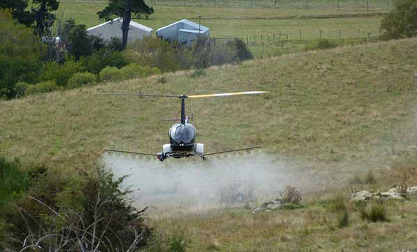
UAVOS has added the R22-UV unmanned helicopter to its agriculture unmanned aircraft portfolio for spraying for diseases, weed and pest control, and vegetation control.
The R22-UV is a manned Robinson-22 helicopter converted by UAVOS to an unmanned aircraft. (Photo: UAVOS)
The Agro-Drone R22-UV is equipped with a specially developed utility to deliver liquid chemicals — the spray system Simplex model 222.
The R22-UV drone is provided with a 100-liter tank for chemicals and can stay airborne for two hours. Weight of the system is 42 kilograms, boom span is 7 meters, and swath width is 14 to 16 meters.
UAVOS listed several advantages that could maximize the value of such a heavy UAV for farmers:
The R22-UV can be operated in the regions without airfields, under severe weather conditions and during night-time, in conditions with a high probability of risk for the pilot.
UAVs are excellent for operations in conditions of high humidity, where the use of ground equipment is impossible or difficult. Unlike heavy machinery, which cannot go into a field immediately after a heavy rain, UAV has no impact on the ground. Drone sprayers don’t touch the ground so there will be less soil compaction. This is when heavy machinery like tractors roll over the soil, pressing it down and damaging it. Farmers can fix this with plowing, but it can be harmful to the soil over a long period of time.
UAV implementation eliminates manual spraying with backpack sprayers, so workers don’t come into contact with hazardous chemicals.
UAVs also enable growers to spray their crops precisely and at will, which is critical for fighting herbicide-resistant weeds. Spraying is better. The rotor of an agricultural drone produces a huge downward rotation force, which promotes the pesticide droplets to penetrate the crop from top to bottom, which is conducive to the pesticide droplets evenly scattered in all parts of the plant, so that the spraying is accurate.
Unmanned aircraft can be used for spot spraying weeds with herbicides and are useful for spraying crops with pesticides. A spot-oriented approach based on preliminary analysis of digital images from robot cameras minimizes the cost of agrochemicals, reducing the chemical impact on soil, water, culture and, ultimately, on the consumer’s body, while achieving higher results of crop cultivation than with traditional approaches. The aircraft can be set on a predetermined GPS-defined route to fly over a field, dropping doses of pesticides, herbicides and fungicides as it flies.
“Precision agriculture is based on the use of valuable metrics to make farmers’ crop management efficient and optimized,” said Aliaksei Stratsilatau, CEO of UAVOS. “Validating-of-damage reports used to be on paper. So, unmanned aircraft help our customers to validate the veracity of reports so that we could come up with a comprehensive solution. Generally, agriculture is very complex and there are a lot of problems, but there are solutions available through the new technology.”
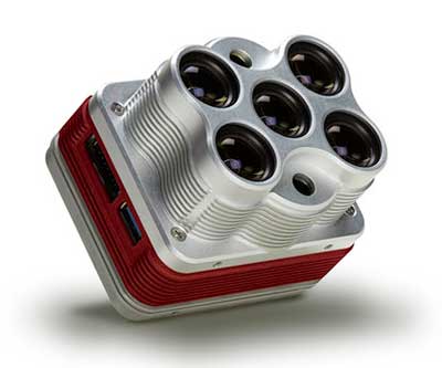
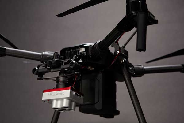
The Altum is a 3-in-1 sensor that combines thermal, high-resolution and multispectral imaging capabilities. (Photo: MicaSense)
The Altum sensor, offered by MicaSense, is designed for professional-grade agricultural drone mapping by enterprise and academic researchers. The Altum captures synchronized multispectral and thermal imagery, enabling aligned outputs for advanced analytics.
Altum’s multispectral imagers are the highest resolution integrated multispectral solution available for drones, allowing for detailed RGB outputs and advanced crop classifications.
Whereas before they had to fly multiple flights with multiple sensors, researchers, growers and service providers can now capture data for plant health, water stress mapping, phenotyping and more in one flight, with one sensor.
“The Altum design resulted from experience developing advanced analytics and understanding needs for advanced research,” said Justin McAllister, CTO and co-founder of MicaSense. “We realized the market is limited by time and cost constraints of owning multiple sensors and flying multiple passes over the same field. The goal of Altum is to simplify the workflow, and with synchronized capture, to provide results that can be correlated and quantified more easily.”
Altum includes MicaSense’s standard five-band configuration of multispectral bands (red, green, blue, near-infrared and red-edge) and an integrated Lepton radiometric thermal longwave infrared sensor from FLIR Systems, providing temperature measurement for every pixel of the scene for additional crop data and optimization.
https://youtu.be/Kdim4uol7S4
Expandable high-capacity USB 3.0 storage allows users to fly longer and cover more area without landing to swap storage. In addition, advancements in image capture rate enables faster flight speeds.
Users can process Altum data with industry standard software like Agisoft and Pix4Dmapper to generate an aligned, radiometrically calibrated six band (R, G, B, RE, NIR, T) geotiff, or access the raw data from Altum to process data themselves.
Included with Altum is DLS 2, the patent-pending next generation of the MicaSense Downwelling Light Sensor (DLS). DLS 2 allows for a more streamlined integration as it combines both the DLS and GPS into one product. In addition, through proprietary MicaSense technology, the DLS 2 will offer significantly better calibration for changing light conditions and better measurements over time.
Integrated solutions
Altum’s multiple interface options and open API gives users the ability to utilize Altum on a variety of platforms. In addition to the DJI SkyPort integration, Altum is integrated with drone offerings from the following companies (with more to come):
North America: Drone Nerds (U.S.), BirdsEyeView Aerobotics (U.S)., OmniView Tech (Canada), Sky Flight Robotics (U.S.), Blue Skies Drone Rental (U.S.)
Europe: 3D Target (IT), Globe Flight (DE), C-Astral (SI), Droneparts.de (DE), Ecobotix (DK), NaviGate (PL), Quantum Systems (DE)
DJI Payload SDK Program: Altum and RedEdge-MX for DJI M200 Series
Through DJI SkyPort, MicaSense is able to provide seamless integration of its specialized sensors with DJI’s powerful line of enterprise drones, resulting in the MicaSense Altum and RedEdge-MX solutions. This provides users a high-quality drone and sensor combination they can rely on to capture quality data every time – with virtually no set-up time.
The DJI SkyPort integration for Altum and RedEdge-MX features plug-and-play integration for Altum and RedEdge-MX right out of the box, including power and quick connect/disconnect, and enhanced light calibration with MicaSense DLS 2.
“Solutions like the MicaSense Altum and RedEdge-MX demonstrate the value of integrating specialized industrial payloads to DJI’s powerful drone platforms,” said Jan Gasparic, head of Enterprise Partnerships at DJI. “By collaborating with solution providers, we are expanding the benefits of drone technology to more and more industries. In the case of agriculture, a specialized suite of sensors and more advanced level of analytics can truly bring tangible value to business workflows and decision making today.”
The Altum and SkyPort enabled RedEdge-MX and Altum are available today through the MicaSense website.
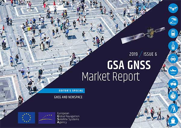
The new GSAGNSS Market Report is now available for download. The report provides a comprehensive overview of the GNSS market and the global industry, as well as a focus on EGNSS differentiators and synergies with Copernicus, according to the publisher, the European GNSS Agency (GSA).
Areas covered include:
A general overview of the GNSS market and a global industry overview.
Analysis of macro-trends affecting GNSS, including climate change and the circular economy, big data, artificial intelligence, the silver economy, cyber security and the sharing economy.
A review of the main GNSS market segments in detail, including trends and developments, forecasts for future shipments, revenues and the GNSS installed base, and a look into GNSS user requirements.
GNSS in Space. This year, the report features the “Editor’s Special: GNSS for NewSpace,” a section that introduces GNSS receivers in satellites and their relation to the evolving space sector.
GNSS market monitoring is a key activity of the GSA. Market monitoring supports GNSS stakeholders in their planning and decision-making, and offers a clear tool to understand GNSS trends and evolutions.
Since its launch in 2010, the GSAGNSS Market Report has become the go-to-source for information on the dynamic, global GNSS market segments and applications.
It’s hard to overstate the importance of inertial sensors in the transportation and machine control markets. For the second year, using inertial navigation systems (INS) to augment positioning was selected by the most respondents (43%) as the best additional solution for positioning in GPS/GNSS-challenged environments.
Inertial measurement units are based on multi-axis combinations of precision gyroscopes, accelerometers and magnetometers using algorithms to determine location, direction and position. Other tech used to increase positioning accuracy includes signals of opportunity (cellular, radio, TV), visual indicators (such as lidar) and ultra-wideband.
Automakers are pushing hard to get autonomous vehicles on our roads and highways. Nissan and Renault (with Microsoft) plan to have 10 vehicles on sale by 2020 with “significant autonomous functionality.”
Ford plans to roll out autonomous vehicles by 2021, and Hyundai is targeting them for the highway by 2020 and urban driving by 2030. While industry experts debate the time frame, it’s clear autonomous vehicles are coming.
Every Tier 1 automaker has an autonomous navigation program, along with heavyweights such as Google, Apple an Amazon. Many automakers are teaming with tech companies on R&D, such as GM with Lyft, and BMW with Intel and Mobileye. Others are teaming with each other —Volkswagen and Ford partnered to acquire AI startup Argo. Daimler has joined Volvo to invest in the platooning concept, connecting trucks through wireless signals.
Stages of Autonomy. The move to autonomous won’t be a sudden jump, but will take place in incremental steps. Formerly only offered on luxury autos such as the Tesla or Mercedes, Honda has introduced semi-autonomous advanced-driver assistance systems (ADAS) options on its entry-level Civic, offering lane-keeping, automatic braking, and adaptive cruise control functionality for the mass market.
Automakers rely on SAE International’s J3016 standard, which defines six levels of automation from Level 0 (no automation) to Level 5 (full vehicle autonomy). The pivotal change occurs between Levels 2 and 3, when responsibility for monitoring the driving environment shifts from the driver to the system.
Chart: GPS World
At Level 1 (driver assistance) is cruise control.
Level 2 (partial automation) includes Audi Traffic Jam Assist, Cadillac Super Cruise, Mercedes-Benz Driver Assistance Systems, Tesla Autopilot and Volvo Pilot Assist.
Level 3 (conditional automation) puts the car in the driver’s seat, but prompts the driver to intervene in a difficult encounter (Audi Traffic Jam Pilot).
At Level 4 (high automation), the car operates without human input, but only under select conditions (road type, geographic area). For instance, the driver might manage all driving duties on surface streets then become a passenger as the car enters a highway.
At Level 5 (full automation), the driverless car can operate on any road and in any conditions a human driver could negotiate. There are no Level 5 autos yet, but Waymo is using a fleet of 600 Chrysler Pacifica hybrids to develop Level 5 tech for production.
Machine Control. Not having to deal as much with traffic, except to navigate to the work site, machines in agriculture and construction are much more autonomous than the family car.
For liability reasons, fully autonomous machines have yet to be approved for field work in the U.S. Nevertheless, manufacturers such as Case IH, New Holland, John Deere and Komatsu are continuing to push the tech, and most tractors sold in the U.S. today include auto-steering systems.
At construction sites, GNSS technology installed in bulldozers, excavators, graders and pavers increase productivity and provide situational awareness to operators. GNSS increases the efficiency and accuracy of these machines, with the input used in task management, data management and theft-detection applications.
Operators rely on GNSS information to position the cutting edge of a bulldozer blade or an excavator bucket. GNSS enables comparison of the position against a 3D digital design to compute cut and fill amounts. Display systems provide the operator with the visual information to manually move the machine’s blade or bucket for highest accuracy.
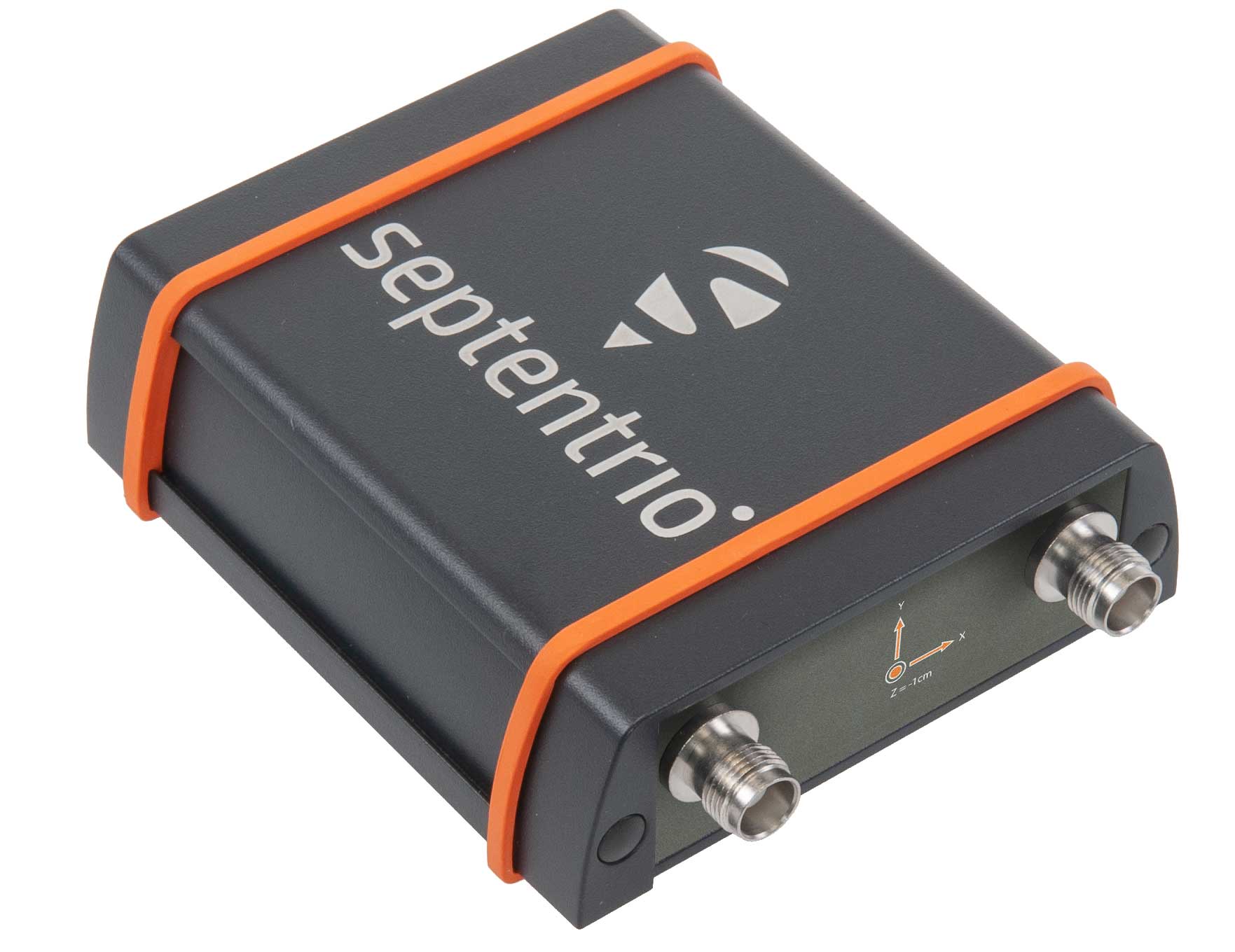
The AsteRX-SBi has a rugged housing, making it suitable for machine control and other outdoor uses. (Photo: Septentrio)
Septentrio has expanded its GNSS/INS portfolio with the AsteRx SBi, a new housed GNSS/INS receiver. The ruggedized AsteRx SBi fuses high-accuracy GPS/GNSS with a high-performance inertial sensor to provide reliable positioning and 3D orientation for machine control and logistic applications.
Within its rugged, waterproof enclosure, a high-performance GPS/GNSS is coupled with an industrial-grade inertial sensor to provide high-accuracy, reliable positioning and 3D orientation (heading, pitch, roll).
Offering the flexibility of either single or dual antenna, AsteRx SBi is designed for quick and easy integration into any machine monitoring or control system. AsteRx SBi packs performance and durability into a single, compact box. Reliable location and 3D orientation data is streamed with a high update rate and constant low latency.
“AsteRx SBi was designed with ease of integration and reliability in mind. Its compact, ruggedized housing is optimized for easy clamping to any machinery,” said Danilo Sabbatini, product manager at Septentrio. “It has all the features and tools needed for straightforward integration into machines or large robotic systems.”
Septentrio reliable centimeter-level positioning is based on true multi-frequency, multi-constellation GNSS (GPS, GLONASS, Galileo, BeiDou, QZSS) technology. AsteRx SBi combines GPS/GNSS and an industry-grade IMU (inertial measurement unit) to deliver precise positioning together with 3D attitude.
The AsteRx SBi is a robust positioning solution for machinery operating in environments challenging for GNSS. (Photo: Septentrio)
Septentrio’s unique GNSS–IMU integration algorithm enables continuous positioning in environments of low satellite visibility where short GNSS outages are possible. This is referred to as coasting or dead reckoning, and can happen near high structures, under bridges or under thick foliage. This makes AsteRx SBi a robust positioning solution for machinery operating in environments challenging for GNSS, such as in container yards, urban canyons or near cliffs.
AsteRx SBi comes with built-in Advanced Interference Mitigation (AIM+) technology. In busy urban environments electromagnetic waves can interfere with GPS and GNSS signals. AIM+ offers protection against such interference resulting in faster set-up times and robust continuous operation. A built-in power spectrum plot allows users to analyze interference, helping locate its source and mitigating it.
Topcon Agriculture launched a number of digital farm management tools, including updates to the Topcon Agriculture Platform. (Photo: Topcon)
Topcon Agriculture launched a number of digital farm management tools, including updates to its cloud-based farm management platform, Topcon Agriculture Platform (TAP). According to the company, the platform integrates state-of-the-art connectivity, cloud services and data analytics. The package is designed to suit virtually any agricultural machine, implement or technology, Topcon added.
The Topcon Agriculture Platform features a new interface designed to increase productivity and profitability for farmers. It also has the ability to provide data on a number of variables, including yield, soil, fertility, imagery and topography.
“We’ve worked with farmers and institutions while beta testing and are excited to roll the platform out to farmers worldwide,” said Brian Sorbe, vice president of global production solutions for Topcon. “It is the ideal solution for mixed fleets, so farmers can focus solely on decisions and action.
“Additionally, the platform can provide seamless connectivity for sharing information so those supporting the farmers, such as dealers and agronomists, can provide real-time support, recommendations and tasks directly to the cab.”
The company also released yield data management tools, an autosteering tool and a GNSS base receiver. The company’s Smart Cart solution is designed to provide farmers with the capability to gather highly accurate, weight-verified, geo-referenced harvest data that automatically uploads to TAP for visualizing, post processing and yield reporting, the company said.
The other yield monitoring solution released by Topcon is the YM-2 YieldTrakk. This system services crops using conveyor-type harvesters, such as potatoes, sugar beets, grapes, onions and tomatoes.
Topcon debuted the HiPer VR mobile base station to provide the latest GNSS tracking technology and RTK capability in a compact, rugged design to bring satellite guidance and value to any agricultural application, as well.
Finally, the company launched its AGS-2 auto guidance system, which provides autosteering for agricultural machine types and models.
“For increased flexibility and connectivity, the system will leverage the new TAP Cloudlynk connectivity devices for RTK corrections via cellular or radio,” Sorbe said. “A major benefit is the introduction of new TopNET Global signal options and SkyBridge, which will reduce downtime by allowing the system to continue steering due to signal coverage interruption’s when using RTK.”
According to the company, Topcon Agriculture Platform subscriptions and cloud connectivity devices — Cloudlynk — will be available worldwide September 2019.
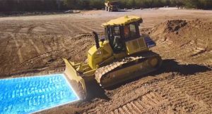
Komatsu America Corp. has introduced Proactive Dozing Control logic, a fully-integrated dozing control system that allows operators to perform auto-stripping, auto-spreading, high production dozing and finish grading.
Built on the company’s intelligent machine control, the system uses GNSS positioning in conjunction with an inertial measurement unit (IMU) to calculate precise position. The two sensors work together to calculate exactly where the tracks are on the ground.
The machine control system communicates with the dozer’s hydraulic controllers, engine controllers and the machine controller. Through cylinder sensor technology, the position of the blade is calculated in relationship to the machine body.
The Proactive Dozing Control logic measures the surrounding ground and determines what has been done on the area being graded, then stores that data and information. When the dozer prepares to go back over that area to cut or work it more, the system understands what it was like from its previous track and, therefore, follows the existing terrain — the very terrain that was just created.
Proactive Dozing Control logic provides real-time position of the machine on the job site to create a highly accurate elevation for the system to drive the blade to the precise grade needed. Using real-time conditions, the system understands what the terrain around the machine looks like and makes calculated decisions — whether it should cut and carry material, whether it should spread or fill that material, or whether it should be finish grading.
The new system is available on the Komatsu D51EXi-24, D51PXi-24, D61EXi-24 and D61PXi-24 dozers.
Photo: Komatsu
“Proactive Dozing Control logic opens up a world of application possibilities for machine control technology,” said Derek Morris, Product Marketing Manager, Intelligent Machine Control and Smart Construction for Komatsu. “Traditionally, GPS machine control focused on finish grade, which meant operators only used the technology approximately 10 to 20% of the time. Proactive Dozing Control logic is a game-changer because the integrated system now lets operators use automation any time, whether for general site clean-up, backfilling trenches and more.”
“A key differentiator is that our system collects data at the tracks, while aftermarket solutions collect data at the blade,” Morris noted. “Because data is collected at the track, the system provides a real-time picture of the ground around the machine, allowing the system to make calculated decisions based on the current terrain. By collecting data at the track level, we’ve created machine control that is far more advanced, offering an entirely new level of efficiency, whether you’re an operator who has 20 years’ experience or someone new to the job, our Proactive Dozing Control logic provides precision work every time, making operation easier and more productive.”
With Komatsu’s Proactive Dozing Control logic, operators can use the dozer to its full capacity, leading to increased utilization, better ROI and better production. Owning and operating costs are also lowered because wear and tear on the machine is reduced by automating operation, Komatsu stated in a press release.
By significantly minimizing track slip during operation, undercarriage wear is reduced, thereby lowering O&O costs, since 50% of the ownership cost of a dozer is the undercarriage.
SoftBank plans to introduce a centimeter-accurate, real-time satnav-based positioning service, specifically using Japan’s Quasi-Zenith Satellite System (QZSS), to guide autonomous vehicles across a range of industries in Japan. The company said it will install more than 3,300 control points at base stations across Japan to deliver centimeter-level accuracy over its mobile network coverage area to provide real-time kinematic (RTK) positioning.
Testing begins in July with a scheduled launch of commercial service by the end of November. Test partners include Yanmar Agribusiness Co., Ltd., a provider of autonomous assisted driving for agricultural machinery, Kajima Corporation, which performs construction site management with automatically controlled drones for aerial photography and monitoring, and SB Drive Corp., a provider of autonomous and assisted driving technology for buses.
SoftBank is developing proprietary low-cost GNSS receivers so that “new services and market expansion can be realized.” A Positioning Core System provided by ALES Corp. will generate correctional data based on signals received and transmitted by SoftBank’s own control points over SoftBank’s mobile communications network to agricultural and construction machinery, self-driving cars, drones and other equipment carrying GNSS receivers. The company expects that centimeter-level positioning can thus be done in real time.
In addition to control points at its own base stations, SoftBank will use the Geospatial Information Authority of Japan’s approximately 1,300 GPS-based control stations.
SoftBank is also developing services to enablec loud-based RTK positioning for devices without GNSS receivers. Cloud-based RTK will provide centimeter-level, location-based services for equipment that needs to be miniature and energy-efficient, such as infrastructure surveillance sensors and wearable devices.
SoftBank Group Corp. is a Japanese multinational conglomerate holding company headquartered in Tokyo. It owns operations in broadband, fixed-line telecommunications, e-commerce, internet, technology services, finance, semiconductor design and more. It is the 36th largest public company in the world, and the 2nd largest in Japan.
ALES is a joint venture established by SoftBank and Enabler in July 2018. Enabler employs GNSS and related technologies to produce such products/services as a synchronization solution for mobile base stations for subway stations and a patented indoor positioning/time synchronization infrastructure platform in Japan.
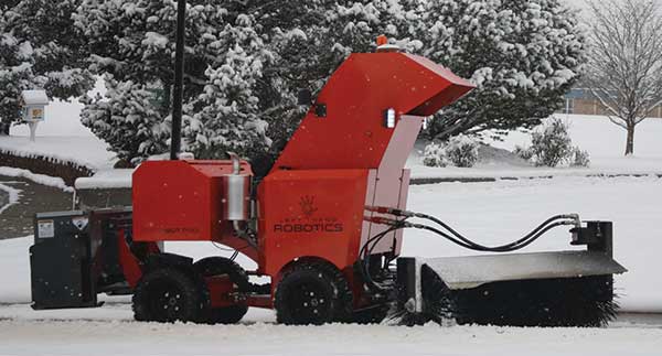
The autonomous SnowBot Pro is ready to clear your walkways. Offered by Left Hand Robotics and guided by Swift Navigation, it is a commercial-grade, robotically driven product for snow removal.
Driving autonomously, SnowBot Pro clears snow from walkways with a 56-inch-wide rotating brush, reducing the number of hand shovelers or snow blower operators needed by up to 80 percent, the companies said. Various front and rear attachments allow for a multitude of tasks, such as snow removal in the front and deicing in the rear. It also reduces potentially costly slip and fall insurance claims.
The SnowBot is programmed and controlled remotely from the cloud via an online dashboard or mobile app, and follows its programmed path using GPS, accelerometer and gyroscope technologies for navigation.
Sensors detect any obstacles and can instruct the robot to stop to avoid collisions and send instructions about how to bypass obstacles. Location, weather and robot status data is recorded in real time, along with before and after photos. The detailed recording helps minimize insurance and risk-management costs while providing customers with proof of work.
The robot has to navigate precisely, avoiding potentially damaging landscaping, walls, curbs and other obstacles along sidewalks and walkways. Centimeter-level GNSS ensures it avoids obstacles and stays on its designated route. Finding a reliable real-time kinematics (RTK) GNSS solution was critical given that many sidewalks are near buildings and underneath trees.
After evaluation, Left Hand Robotics chose Swift Navigation’s Piksi Multi. Its centimeter-level accuracy keeps the robot in its designated path and allows its base robot platform to navigate in a variety of environments, whether in lines (sidewalks, bike paths) or large open areas (fields, parks). The Piksi Multi also retains a GNSS fix in challenging conditions and environments.
Once Swift’s ruggedized Duro receiver was launched — and could be used by customers as a base station that was required for RTK — Left Hand Robotics had a complete offering for customers, which it launched in the winter of 2018–2019.
A Piksi Multi is installed in each SnowBot Pro, and its Path Collection Tools (tools customers use to collect the initial path data the robot will follow) and Duro is used as the base station controlling the SnowBot Pro robot.