Trimble’s PCS900 Paving Control System version 2.20 is designed for GOMACO and Guntert & Zimmerman placer/spreader machines. The new version of PCS900 further automates the paving train by enabling contractors to use GNSS-based positioning, in conjunction with a base station, to steer the machine and control the machine’s elevation according to a 3D model. This can significantly improve paving productivity and reduce material waste on concrete road and airport surfaces.
With the availability of GNSS-based 3D machine control for placer/spreaders, paving contractors can move their Trimble GCS900 Grade Control System display, radio, sensors and GNSS receivers between even more machines in their fleet. By using Trimble grade-control components on their placer/spreader, users can realize a faster return on their investment for Trimble technology, the company said.
In addition, factory-fit integration between GOMACO and Guntert & Zimmerman placer/spreaders and the Trimble PCS900 system gives contractors an easy-to-learn, seamless paving control solution, Trimble said. Operators can make any necessary adjustments to machine guidance with the onboard 2D system they are familiar with, lowering the training time needed to learn a new system.
Without machine control, a concrete placer/spreader is controlled manually or by two stringlines, one on each side of the lane being paved. Using the PCS900 system, time-consuming labor spent setting up these stringlines can be eliminated. The Trimble PCS900 uses GNSS-based positioning to keep the placer/spreader on the target alignment, design and slope so contractors can spread material faster and more efficiently while reducing labor costs.
The Trimble PCS900 system version 2.20 is currently available for GOMACO placer/spreader machines with G22 or G+ machine controllers through GOMACO in North America. PCS900 version 2.20 for the Guntert & Zimmerman placer/spreader machines running the EGON machine control system is available through Trimble’s worldwide SITECH® Technology Dealer Channel.
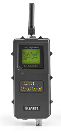
Satel’s new UHF radio data modem Compact-Proof, designed for outdoor measurement applications, features autonomous rechargeable battery power and a robust housing with IP67 protection.
Compact-Proof from Satel gives users double advantages with a powerful lithium-ion battery and the EASy radio data technology including a display and a robust housing with IP67 protection, the company said. With transmitting power of 1,000 mW, it can be operated fully autonomously as a repeater station in the field for more than 15 hours. The power can also be supplied parallel via an external rechargeable battery with a solar panel; alternatively, the Compact-Proof can be recharged overnight, and within five hours it is ready for the next work day.
The user-friendly installation, robust IP67 housing and 4-pin and 8-pin ODU connections make the new radio data modem Compact-Proof attractive for measurement applications, Satel said. The device features all functions of the Satel radio data modems EASy and 3AS and is 100 percent compatible with these solutions.
In addition, it supports the radio protocols of Pacific Crest, Trimble and other GNSS providers, which expands the areas of application.
Whether in the rainforests of Vietnam or in the Arctic, the temperature range of -30°C to +65°C and the frequency ranges of 330 MHz…420 MHz and 403 MHz…473 MHz make the Compact-Proof a reliable partner for all outdoor applications, Satel said. The housing features a robust, compact design with a display and foil keyboard.
As a light version — without an internal battery — the device offers numerous advantages for outdoor applications and even withstands the harsh conditions of machine control environments, for example.
In Germany, radio data transmission solutions from Satel are distributed exclusively by systems provider Welotec.
GPS landforming is the reshaping of a fields topography to predesigned 3D surfaces using high-accuracy GPS to control the blade height of the earth-moving machine. It is typically done to improve surface drainage and water infiltration uniformity.
Davco Optisurface, the company that developed the 3D landform design software OptiSurface Designer, has seen strong adoption as the concept catches on. The software has been used to design more than 400,000 acres, according to Arkansas-based global sales manager Preston Marthey.
WM-Form. Trimble launched a GPS landforming software program in February. WM-Form enables growers and contractors to turn their fields into optimal surfaces, even in areas that could not be leveled before, Trimble said.
“With more farmable land that is optimized for water management and more uniform production, growers can experience increased yield,” said David Fitzpatrick, Water Solutions business area director for Trimble’s Agriculture Division.
Trimble’s product is designed to work with its WM-Topo survey system and Trimble FieldLevel II system. WM-Form has surface design tools and flexible parameters so growers and earthworks contractors can use it to repair underperforming areas and extend the amount of productive farmable land. It can reduce the volume and cost of earthworks and minimize disturbance to valuable topsoil. Growers can optimize water distribution and drainage, reduce erosion and flooding by effectively directing waterflow, and create more uniform crop production that can lead to increased yield.
Growers can analyze topographic data in WM-Form to identify surface problems limiting yield potential and create a design that optimizes their field’s surface. The software also provides reports for volume, area and constraints, providing an accurate quote on the total cost of the project.
Horizon. Topcon’s Horizon software is an icon-based, user-definable system that presents a choice of views for each function you perform. It runs on all three of Topcon’s X family of precision agriculture consoles. With Horizon, growers can set autosteering patterns, control application rates, monitor operations, and map every pass — and a new feature allows for water management.
“Water conservation…is designed to provide the ability to perform land forming while also offering GNSS auto steering of the tractor,” said Neal Toso of Topcon Positioning. Using the Topcon X30 and AGI-4, water conservation and land forming users can level fields while auto-steering to maximize efficiency and reduce the amount of material moved, he said.
“With the X30 console, using Horizon software, connected to Topcon MC-R3 blade control, it is easy to take the output from Topcon AGForm 3D design software to produce accurate modeling and land forming. This allows proper drainage to occur, resulting in a healthy, productive crop,” said Toso. “Together, these Topcon products are designed to provide a turnkey approach to superior landforming operations.”
In Costa Rica, Jose Maria Aguero, CEO-director general of Agricultura Cientifica S.A., now uses Horizon. Aguero first employed laser leveling in the late 1970s. “We started noticing that rice and other crops produced less in areas with deep cuts from laser leveling because we had cut the more fertile topsoil off,” Aguero said. “But it was the only tool we had, so we kept doing it.”
Then Aguero discovered Topcon’s GPS land forming products. “Sugar cane crops are expanding dramatically in our area, and the operators don’t use irrigation. Water management is needed to improve drainage because in the rainy season it is too wet, which affects crop development. The only way the cane companies can get sugar cane into a new growing area is with GPS and 3D landforming,” he said.
“GPS with 3D landforming only moves 250 to 300 cubic meters per hectare,” Aguero said. Compared to laser leveling, “That is more than a 90 percent reduction in cost. And, moving less soil keeps more of the fertile top layer in place to promote fertility.”
Landforming Lessons
Surface drainage and irrigation problems can be solved with GPS landforming at low cost, agricultural engineer Graeme Cox says. This is proven with many crops and farming styles, irrigated and non-irrigated.
Cox has learned the following about GPS landforming, based on his experience around the world.
Water is king. Eighty percent of yield variability and profit loss is due to too much, or too little, water. Yield maps show this. “Focus on optimizing water management first,” Cox said.
Ponding kills profits. If water is standing in fields 24 hours after rainfall or irrigation, it is killing profits. “Expect eight percent per day yield loss plus nitrogen loss, increasing pest and disease, delaying planting, spraying and harvesting.”
Subsurface tile drainage is good, but expensive. “Tiling typically has a lower return on investment than GPS landforming and does not work well on heavy soils or those with limited elevation relief,” Cox said.
Ditching is good. “But,” he adds, “it can be a pain if ditches take out valuable crop area or restrict machinery access.”
Lasers are dead. Lasers only work in a straight plane. GPS allows farmers to follow curved topography with curved design surfaces.
Earthworks and topsoil movement can be reduced up to 80 percent with landforming designs and GPS machine control compared to other methods, Cox claims.
Septentrio this week is launching two successors to its APS-U: The AsteRx-U and the AsteRx-U Marine multi-constellation dual-antenna receivers. The AsteRx-U will be presented to the public for the first time at two trade shows this week. ION GNSS+ takes place Sept.14-18 in Tampa, Fla., and INTERGEO 2015 will be held in Stuttgart, Germany, Sept. 14-18.
The AsteRx-U and the AsteRx-U Marine incorporate the latest GNSS tracking and positioning algorithms and interference mitigation. Machine-control users in the agricultural and construction industries, as well as users in marine and mining industries, benefit from a complete system with integrated UHF radio, Wi-Fi, USB, Bluetooth and cellular connectivity and a spectrum analyzer, Septentrio said. All configurations can be done via the on-board web interface.
The AsteRx-U and AsteRx-U Marine feature a full range of positioning techniques and algorithms to ensure that users have the highest accuracy and reliability. The spectrum analyzer enables users to visualize the RF spectrum. Based on its extensive experience with real-life interference sources and their mitigation, Septentrio has developed interference mitigation technology that automatically counteracts various kinds of ambient intentional and unintentional RF interference.
The AsteRx-U family of receivers is built around Septentrio’s latest ASIC, GReCo4, which was introduced in 2014. It incorporates built-in jamming detection and countermeasures, multi-path rejection, fast acquisition and other advanced features. Both receivers have more than 500 hardware channels to track all available constellations (GPS, GLONASS, Galileo, Beidou, IRNSS and QZSS) and feature many algorithms: LOCK+ technology to maintain tracking during heavy vibration machine use and IONO+ technology to assure the accuracy of the position even in regions of elevated ionospheric activity.
The AsteRx-U has decimeter- and centimeter-level RTK positioning including TerraStar. The AsteRx-U Marine also supports Veripos PPP augmentation services. It includes extra anti-jamming technology to counter Iridium and INMARSAT-uplink interference, as well as an extra antenna connector for a dedicated L-band antenna to optimize L-band reception at high latitudes.
Straightforward to set up and integrate with existing systems, the AsteRx-U and AsteRx-U Marine use any device with a web browser to facilitate usability and configuration for the user.
“We want to make it easy for our customers to use high-accuracy positioning in their work,” said Jan Leyssens, Septentrio product manager. “Using the integrated communication functionality in the compact and portable AsteRx-U, users won’t have to worry about adding their own modems or UHF radios to get access to corrections.”
Leyssens continued, “The receiver web interface is available wirelessly on any mobile device. It was designed together with several of our key customers, resulting in an interface that is not only easy to use by field operators, but also provides many useful troubleshooting tools, such as the spectrum analyzer, to solve problems in the field and minimize downtime.”
Septentrio will be at Booth 318 at ION GNSS+, and at Hall: 4, Booth: D4.014, at INTERGEO.
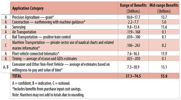
Table 1. Preliminary 2013 U.S. GPS economic benefit estimates. (Chart: GPS World, based on data from author)
This article is based on a presentation to the National Space-Based Positioning, Navigation and Timing Advisory Board in June 2015. The study reported on at the meeting was requested by the National Executive Committee for Space-Based Positioning, Navigation and Timing. It demonstrates the widespread use and importance of GPS to the U.S., with estimated benefits in 2013 of about $56 billion, or 0.3% of GDP for a subset of applications. The study is the first part of an effort that is expected to refine and extend this analysis.
By Irv Leveson
Critical to many civilian applications and innovations, GPS brings great economic benefits. These benefits have grown rapidly with the integration of GPS with other technologies and its wider and deeper infusion into applications. New GPS signals and other improvements in the system will further expand and enhance use. The unmistakable conclusion: GPS is everywhere.
Benefits of GPS to the U.S. will increase with the availability of other GNSS systems, even though GPS will constitute a smaller share of global GNSS benefits. The U.S. will continue to provide leadership, standards and innovation in technology and applications with positive domestic feedback.
GPS and other GNSS and enhancements raise productivity; reduce and avoid costs; save time; enable improved and new production processes, products and markets; increase health and well-being; reduce injury and loss of life; improve the environment; and increase security.
The National Executive Committee for Space-Based Positioning, Navigation and Timing (PNT), which is responsible for maintaining U.S. leadership in GNSS, commissioned a study to assign a quantitative value to the broad economic uses of GPS. The purpose is to inform the public, federal decision makers and critical infrastructure owners/operators on the importance of GPS and the need to protect it from disruption. Assessing the economic implications of actions such as preventing or disallowing interference, spectrum reallocation, developing supplementary or backup systems and/or toughening receivers can be informed by value estimates and the data used to derive them. In addition, economic values can contribute to planning for GPS modernization and analysis of budgets. Baseline estimates facilitate comparisons with future developments. GPS benefit estimates will be “ballpark” no matter how sophisticated the methodology because of limits to the availability of information, but in many cases, knowing orders of magnitude is essential in choosing courses of action.
Widespread, Pervasive Impact. The technological environment is one of rapid changes in information and materials technology and integration of technologies at levels ranging from systems on a chip to large-scale systems. GPS is increasingly integrated with other technologies and systems that build on each other to achieve greater outcomes.
The U.S. Department of Homeland Security counts GPS as an enabling technology because of its crucial role in 14 of the 16 industries that are classified as part of the nation’s critical infrastructure. It is useful to view GPS’ role as being especially important in “enabling the enablers,” industries that particularly support the rest of the economy and are at the forefront of economic growth. The most notable of these are transportation, communications, power and financial services.
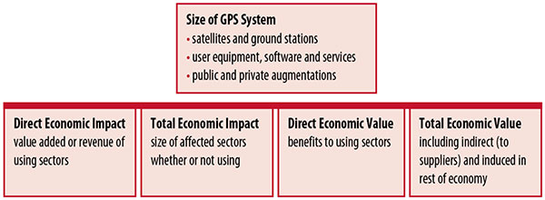
Economic Value versus Impact
Economic value is the addition to the value of the economy from the provision of a good or service, or the introduction of a technology. Benefits are measured relative to what would have been expected if there were no GPS. Direct economic value is the increase in value in using sectors. Total economic value includes increases in value to suppliers and value induced in the rest of the economy.
Direct economic impact, on the other hand, refers to measures of the importance of sectors that are using GPS. Total economic impact is the importance of sectors affected by GPS, whether they are using it or not. Total economic impact of GPS is virtually the size of the whole economy, so it is not very meaningful.
Direct economic impact is measured by value added of using sectors when the purpose is to avoid duplication among sectors that buy from and sell to each other. It may be measured by revenue for a single sector when adding sectors is not involved, so there is no need to avoid duplication.
The distinction between economic value and economic impact is critical. Even if economic impact is measured by value added rather than revenue, the value is not the net addition to the economy from the use of the product or technology. It is only the size of the using sector. See Figure 1.
Figure 1. Measuring GPS economic value and economic impact. (Chart: author)
The GSA Study
The most comprehensive estimates of global GNSS market size come from the European GNSS Agency (GSA), which has released four market reports from 2010 through 2015. The data are measures of economic impact and not economic value. The reports are of great interest because of their comprehensive global look at the sizes of markets and inclusion of forecasts. In contrast, the emphasis in this part of the present study is on current economic value, with U.S. benefits assessed for GPS.
One reason for interest in the GSA reports is that market information and projections often are proprietary and there can be great inconsistency across market research studies. GSA makes use of many confidential studies without revealing which sources contributed to each estimate. It apparently has been allowed to incorporate proprietary information from a number of market research firms since the data is subsumed in GSA’s own estimates and/or presented in graphs for which underlying numbers are not provided — and from which it is often difficult to even roughly extract them.
The 2015 report stated the methodology as: “The underlying forecasting model uses advanced forecasting techniques applied to a wide range of input data, assumptions and scenarios…Where possible, historical values are anchored to actual data.” Results were checked against opinions of market segment experts and market research reports. However, these analyses are not provided in the reports and have not been made available.
A distinction is made between the core market which covers the value of components that provide GNSS functionality in devices and enabled markets which “represent the services and devices enabled by GNSS.” The 2015 report provides global data on both core and enabled market and goes into much more detail on core markets for application sectors. In addition to providing sector information that did not appear previously, the 2015 report presents data on the extent to which each combination of the GNSS constellations was supported by receivers or chipsets offered by suppliers. Additional information on enabled sectors is in earlier reports.
GSA found in its 2015 market report that:
3.6 billion GNSS devices were in use globally in 2014, of which 3.08 billion were smartphones and .26 billion were for road.
North America had about 450 million devices installed (about 80% U.S.).
North America had 1.4 devices per capita in 2014.
North American shipments were 250–300 million in 2013.
Global core revenue was estimated at roughly €62 billion and enabled revenue at €227 billion in 2014. As noted, core revenue includes GNSS device components, software and services, while enabled revenue refers to applications.
Location-based services (LBS) was projected to account for 53.2% of 2013–2023 core revenue growth, and road for 38%.
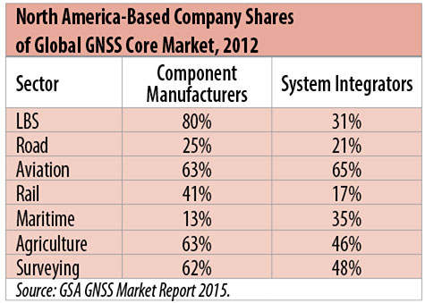
North American-based companies had sizeable shares of the global GNSS core market in 2012, particularly among component manufacturers. (See Table 2). Their market share among system integrators was highest in aviation.
North American-based companies had a 44% market share of value-added services revenue in 2012.
Table 2. North America-based company shares of Global GNSS core market, 2012. (Chart: author)
Markets and Applications
The pervasiveness of GPS-enabled applications is illustrated by the following statistics:
900 million mobile phones that incorporated GPS were sold globally in 2012.
The U.S. had 188 million smartphone subscribers and 263 million Internet users in 2013.
20% of U.S. mobile phone users get up-to-the-minute traffic or transit information.
The new industry category in the 2012 North American Industrial Classification System: “Internet publishing and broadcasting and web search portals” had U.S. revenue of $87 billion and 181,000 employees in 2012.
Google estimated that its search and advertising tools provided $111 billion in economic activity in the U.S. in 2013.
Deloitte estimated that Facebook enabled $104 billion of economic impact and 1.2 million jobs in North America in 2014.
Google Play and the Apple App Store each had more than 1.2 million apps in 2014.
How GPS Is Used. Uses of GPS include:
In agriculture for auto-steering tractors, combines and sprayers for precise operation, variable rate technology for precise placement of seed, fertilizer and pesticides, and for yield monitoring.
Managing forest health and ecological restoration, reducing fire and other hazards, and harvesting forest products.
In commercial fishing, navigation, finding fishing locations and monitoring fish catch by authorities.
In construction to direct the movement of dozers, excavators, pavers, scrapers, compactors and other heavy equipment and the placement of blades to give precise results.
In open-pit mining to guide loaders, dozers, drills and draglines.
In offshore energy exploration and development, for drilling, installations, pipe laying, diving operations, pipe inspection, repair and abandonment.
In surveying, to greatly reduce costs and to improve quality of products that rely on it.
In aviation, for navigation and monitoring positions of aircraft and for satellite-based augmentation systems (WAAS in the U.S.). GPS is the principal source for navigation for aircraft equipped with Area Navigation (RNAV) or Required Navigation Performance (RNP).
Railroad train pacing systems for cruise control, positive train control to keep track of train location and movement authorities, track defect location, and locating trucks with rail workers.
In marine transportation, for navigation, collision avoidance, communications and situational awareness and for monitoring by offshore authorities.
In vehicles, with handheld and embedded devices for navigation and fleet management.
For precise timing and time synchronization and frequency coordination (syntonization). It is used most notably in broadcasting and communications, including both cell phones and traditional telephone applications and the Internet, so packets arrive at the same time, for power generation and distribution to locate problems, and in financial services for time-stamping transactions.
In first responder services for location, navigation and communications and in emergency warnings and evacuations.
In structural monitoring of dams and bridges.
In environmental monitoring, including vegetation growth and sea-level change.
LBS and GIS
Rapid growth is taking place in location-based services (LBS) and geographic information services (GIS), which include everything from indoor location to many aspects of the Internet of Things and the “sharing economy,” and sophisticated systems for information management, analysis and display.
GPS is used for tracking and inventorying assets ranging from heavy machinery on farms and construction and mining sites, to pipes and other materials, containers in trucking sites and ports, and the location of utilities in the ground. In logistics it facilitates planning of product flow and transport.
The growth of same-day delivery — which takes advantage of Internet, cell phone, and location and navigation technologies enabled by GPS — is a continuation of the growth in just-in-time delivery that has been a phenomenon in manufacturing for several decades. Now it is having a profound effect on wholesale trade, retail trade and transportation.
The size of the LBS and GIS sectors is not defined and measured in a consistent way, and except for vehicle use, there is little information on productivity and saving in costs and time. (See sidebar box.)
LBS and GIS Market Size Estimates
For LBS and GIS, definitions and measures can vary greatly and often are not explicit.
Location-Based Services Market Size Estimates
Frost & Sullivan estimated the global LBS market at €22.8 billion in 2012 and forecast €32.0 billion in 2015.
Market and Markets estimated global LBS revenue at $8.1 billion in 2014.
Berg Insight estimated North American LBS revenue at $835 million in 2012.
(The U.S. can be assumed to spend 20–25% of the world value and about 80% of the North American value.)
Geographic information Systems Market Size Estimates
BCG estimated revenue of the U.S. GIS industry at $73 billion in 2011.
The global GIS market will reach $10.6 billion in 2015, according to a report of Global Industry Analysts in 2013.
The Canadian Geomatics study found private-sector spending of $2.3 billion in 2013. If U.S private spending was the same percentage of GDP, it would be $23.6 billion.
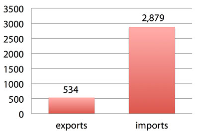
International Trade
Official data show a $2.3 billion U.S. deficit in trade in GPS equipment in 2013. This gives an incomplete and misleading picture of the role of the U.S. and the benefits that result. See Figure 2.
Figure 2. U.S. trade in GPS equipment, 2013 (millions of dollars). (Chart: author)
The trade numbers for GPS equipment do not include revenue for licensing, international payments received by social media and e-commerce companies, or other Internet-based revenue for which the U.S. may have a substantial net trade surplus and which are an important source of revenue and profits of U.S.-based companies.
Imports of GPS equipment software and services enable the U.S. to gain more efficient production in many applications at home and enable the U.S. to export more goods and service that rely on GPS.
Exports of GPS equipment come back to the U.S. as components that benefit U.S. businesses and consumers with more capable products and lower prices. Exports of GPS equipment enable other countries to build on the technologies and contribute to innovation, while imports enable the U.S. to share in foreign innovations. Exports of GPS equipment and associated knowledge also raise incomes in other countries, creating larger markets for U.S. goods and services.
Scope of Benefit Estimates
The U.S. benefit estimates reported here are the result of an initial effort and are not meant to be comprehensive. More work is expected to be done to fill in some of the gaps.
Sectors were chosen based on availability of information to permit relatively robust estimates and importance to the economy or policy issues. These considerations limited the number of sectors for which estimates could be made. Methods were determined based on the nature of available studies and varied among sectors. Only economic benefits were included, with health and safety and environmental benefits left for later research.
Benefits include the value to users above their costs (consumer surplus). Benefits of GPS are compared with alternatives without GPS or an application using it (counterfactuals). Estimates are gross. They are not reduced by the costs of achieving the benefits. Contributions of augmentations are included, since a quantitative basis for separating them is not available.
Estimates were primarily benefits through productivity and cost savings in operations, with savings in input costs included where their magnitudes were clear. Benefits to the rest of the economy are not included. Illustrative allowances were made for the contributions of other technologies and systems to the outcomes examined.
In the case of GPS timing, the estimates were based on the costs avoided by not having to develop an alternative timing source on the assumption that the type of alternative source possible would have evolved from the time GPS became available. The measure does not represent the value of GPS time and synchronization to the nation and to users relative to the absence of a precise time and frequency source.
Government was included in the estimates for construction, surveying, and fleet and non-fleet vehicles. For timing and non-fleet vehicle benefits, two alternative measures are averaged. Sectors with lower quality estimates — rail and maritime transportation — were included because of their importance to the economy. Shares of benefits attributable to GPS were rough assumptions. More robust estimates would require extensive data collection and interviewing in studies greatly exceeding available time and resources.
The primary focus was on productivity improvements, cost savings and cost avoidance, where costs include users’ time. Productivity increases and cost reductions allow more to be produced with the same amount of resources in the sectors utilizing the technology or allow resources to be freed up for other purposes. In that sense, they are equivalent.
When benefits are measured by productivity gains or cost savings, much of consumer surplus (the value to users above what they pay) is implicitly included. Some sources measure value by willingness-to-pay. Willingness-to-pay includes consumer surplus. It also encompasses costs of the purchase and other costs incurred by the user.
Criteria for Selecting Sectors
The potential for making sector estimates of economic benefits was categorized in three basic levels:
confident: based on robust estimates.
indicative: based on one or more less robust estimates.
notional: illustrative, if major contributions of other technologies are not separated and estimates must be based on a plausible percentage of a larger benefit, or if information is not available and estimates must be based on a percentage of market size.
Choices among categories for estimation and estimation methods depended not only on which of the basic criteria are satisfied but also on the following additional criteria:
The importance of the sector to the economy, for example as an enabler of other activities.
The potential use of benefit estimates for the category as an input into analyses of the effects of signal disruption.
Several dozen studies were assessed to determine categories for inclusion and to select studies that can form the basis of estimation. Studies for use in estimation of benefits in a category were chosen according to how well they met the following criteria:
GPS. A test of introduction of GPS or comparison with and without GPS rather than benefits of a broader service.
Coverage. Estimates that cover a major part of the category.
Robustness of estimates, including the type of review the source is likely to have had.
Consistency. If alternative better estimates are not in such a wide range that an average is less meaningful except where explainable by expected sources of variation.
Timeliness. Preference to a recent period being covered by the estimates.
U.S. Economic Benefit Estimates
Preliminary estimates of economic benefits for included U.S. sectors totaled $55.8 billion in 2013. Averaging the alternative estimates, the sum of the benefits in the two vehicle categories is $25 billion, by far the largest of the sectors estimated. Next were agriculture with $13.7 billion, and surveying with $11.6 billion.
Economic benefits are underestimated for several reasons. Some sectors are not included because of lack of information on productivity and cost savings, namely LBS other than vehicle, including asset tracking and locating people; GIS and mapping other than nautical charts, forestry, fisheries, mining, energy exploration and development, land and coastal management, weather, and scientific applications and space.
Parts of others are not included: non-grain agriculture, construction other than earthmoving, GPS in aviation for some Area Navigation (RNAV) Standard Instrument Departure Routes (SIDs) and Standard Arrival Routes STARS) and Required Navigation Performance (RNP), and rail other than positive train control.
Some estimates are conservative. The value of saved time in non-fleet vehicle transportation is based on the recommendation of the Transportation Research Board rather than the much higher value used by the U.S. Department of Transportation.
Some types of benefits are not included — specifically, benefits of GPS timing applications above the cost of alternatives, and avoided income loss, property damage and medical costs associated with reduced accidents and improved emergency response.
Increases in benefits between 2003 and 2005 are not estimated.
And, as indicated, non-economic benefits such as those to health, safety, security, reduced loss of life and to the environment are not yet addressed.
Benefits as measured thus far are about 0.3% of GDP in one year. If all of the excluded sources of benefits were quantified, the benefits would be much larger.
Estimating Benefits for Sectors
U.S. economic benefits of GPS for grain farming were estimated for farms with grain sales of $250 million or more. The same method as was applied for earthmoving in construction.
A composite range of percentages of productivity gains and cost savings of 18–25% was determined from various studies. In the case of grain farming, benefits also come from yield increases due to improvements in plant health. The productivity gains used in the calculations incorporated both sources of benefits. Productivity was taken together with market size and an estimate of 68% adoption of technologies taking advantage of GPS to compute initial estimates of benefits. A notional adjustment was then made to exclude the contributions of other technologies and GNSSs. While having the adjustment determined by a group of experts would have been preferred, that was not possible with the time and resource constraints of the study.
Benefits of GPS machine guidance with earthmoving in construction were calculated based on an 8–12% share of construction for earthmoving operations, a benefit of 18–22% and a 20–25% adoption rate, relying on a number of sources.
For surveying, an estimate of market size was constructed based on U.S. Bureau of Labor Statistics data on numbers of surveyors, cartographers and photogrammetrists in the engineering services industry vs. the rest of the economy, together with revenue data for private surveying and mapping from the Economic Census. This was combined with a composite estimate of productivity gains over conventional surveying of 45–55% and an assumption of 100% adoption.
The benefit values for air transportation were estimated for the study by the Federal Aviation Administration (FAA) based on effects of WAAS and performance-based navigation (PBN). The rail estimates cover only positive train control, which is in early stages of implementation. Information is highly uncertain, but impacts as of 2013 are small. Maritime benefits were based on updating an earlier estimate of benefits of the private-sector value of nautical charts. The estimates for fleet vehicle-connected telematics were based on savings found in an extensive survey of fleet customers over a five-year period.
Timing benefits were based on the avoided costs from not having to develop an alternative source of timing. Alternatives considered were eLoran and a system of three geostationary satellites. Since there would have been strong pressures to develop an authoritative timing source in the absence of GPS timing, it was assumed that one of the alternatives would have been developed rather than assuming as in other cases that technologies in use when GPS became available would have continued in use.
Two estimates also were made for consumer and other non-fleet vehicle use. One was based on extrapolating results of a study of consumer willingness to pay for navigation services, and the other on time saved by navigation services.
Part of the benefits of LBS other than those that are vehicle-related and for GIS are implicitly included in estimates for sectors that use them.
Data and Research Needs
Additional work would be desirable to extend and refine the GPS economic benefit estimates, quantify safety-of-life and environmental benefits, examine international benefits, assess potential future benefits and consider loss from denial of GPS. Benefits of many new and rapidly growing services are yet to be quantified.
Systematic research is needed to fill in gaps in adoption, productivity and cost savings with comparative before-and-after studies as well as with case studies. Robust studies require major and often multi-year efforts involving targeted data collection, which are rarely done by government or academics for GNSS. Information needs to be much more granular, taking into account specific functions in which GNSS is used (such as plowing, seeding, fertilizing, harvesting), specific GNSS and non-GNSS technologies employed in each function at each site, and extent of their use.
Also, results for GPS might be improved or at least be more acceptable if the contribution of other technologies and GNSSs to measured benefits were assessed by a group of knowledgeable individuals rather than by a single researcher.
Information on market size, penetration and growth from market research firms, which tends to capture recent developments, is based on greatly varying sources and methods, resulting in major gaps and great divergence in estimates, especially in new or rapidly growing areas like LBS and GIS. The North American Industrial Classification System (NAICS) and its application in federal data collection such as in the Economic Census lags far behind in recognizing new categories and providing sufficient detail. Lags in data collection and research lead to understatement of the use and benefits of GPS.
Looking to the Future
Future benefits are expected to be even greater because of evolution of technologies, expansion of GNSS systems, creation of new products and markets, and growth and penetration of markets. The possibilities are suggested by the numerous nascent applications that have been emerging. Many will be enabled by expanding GNSS systems, signals and capabilities in conjunction with geographic expansion and increased capabilities in wireless systems.
The progression of platforms is long and growing: mainframes, PCs, mobile phones and other handheld devices, tablets, game controllers, wearables, TVs, home appliances, air and space — including planes, UAVs, satellites, planets, moons, rovers, rockets and spaceships.
The widespread availability of platforms and the growing ability to utilize them promises a long way to go in developing applications and deriving benefits.
Acknowledgments
The author thanks the PNT Advisory Board and Gov. Jim Geringer, liaison from the board to the study; Jason Kim of the Department of Commerce who oversaw the project; Jim Miller of NASA; and the members of the interagency Economic Study Team that advised the effort. Numerous additional people in and out of government provided information and assistance. Responsibility for the content and findings rests with the author.
IRV LEVESON, who has a Ph.D. in economics from Columbia University, is an economic and strategy consultant and founder of Leveson Consulting. He has done extensive work on GNSS markets and issues for more than 10 years. He is a member of the Institute of Navigation, the American Economic Association and the National Association for Business Economics.
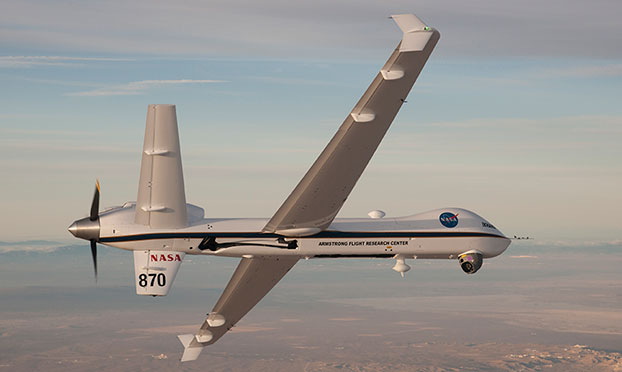
NASA’s Ikhana is being used to test a system that will allow uncrewed aircraft to fly routine operations within the National Airspace System. (Credit: NASA)
NASA plans to install a Locata network (LocataNet) as the core positioning technology for safety-critical unmanned aerial systems (UAS) research at its Langley Research Center in Hampton, Va., according to an announcement by Locata.
NASA Langley is tasked with performing rigorous and repeatable scientific evaluation of new UAS safety and technology concepts under development. The LocataNet will provide high-precision non-GPS-based positioning, navigation and timing (PNT) that is essential for this work. Known for its long history of aeronautics research, NASA Langley is a key center for UAS research and development. In June, one of Langley’s unmanned hexacopters (a drone with six rotors) delivered medical supplies to a clinic, the first such delivery by an unmanned drone.
Locata’s centimeter-accurate positioning will now assist NASA to develop and improve flight-critical technology systems that support air transportation safety, efficiency and performance. Langley’s extensive state-of-the-art facilities will be further enhanced with the installation of the LocataNet.
The NASA LocataNet is scheduled to be installed and commissioned before the end of 2015. Locata will supply the LocataLite Transmitters and Locata receivers required by NASA for the installation. Aviation-quality Locata antennas, developed by Cooper Antennas (UK) and previously used by the U.S. Air Force in its own military LocataNets, will also be installed. Locata engineers will support the physical installation, ongoing training and the future technical support required by NASA Langley for this world-first UAS deployment.
Locata Corporation has invented new terrestrial positioning networks which function as local, ground-based replicas of GPS. These networks can be thought of as “GPS hotspots,” according to the company. Locata has amassed 146 granted patents to date protecting these innovations, with many more patents in the works.
Locata is currently shipping commercial systems to demanding and professional end users such as the USAF, NASA, Leica Geosystems, and many others. Locata enables their integration partners to extend GPS-like positioning coverage to modern industrial, commercial, consumer and government applications in areas where GPS is erratic, jammed or unavailable.
“Locata is proud and delighted to have received an order for NASA’s first LocataNet. Globally significant installations like this prove Locata’s new technology is delivering unprecedented levels of performance to many important new applications,” said Nunzio Gambale, Locata CEO. “As our technology roll-out begins to gain pace, the exceptional value Locata brings to next-gen mobile apps has attracted interest from players all over the world. In fact, our list of relationships is now looking like a roster of the world’s crème-de-la-crème. I honestly can’t think of a better or more prestigious name than NASA to add to our growing partner list.”
“Our team is savoring the opportunity to work alongside NASA engineers and we’re excited that Locata will help advance the safety-critical performance of Unmanned Aerial Systems,” he continued. “Almost all future mobile devices or machines, be they on the road, in the air, on a mine site, in a port, in a warehouse, in your mobile phone, or part of the inevitable Internet of Things — all of them are critically dependent on pervasive, reliable, high-accuracy positioning. Locata is being leveraged into these next-gen systems because it’s clear that satellite-based solutions alone can no longer deliver what’s required. Soon, as we bring miniaturized Locata transmitters and receivers to market, our innovations will enable even greater advances in cutting-edge consumer, commercial, and government applications.”
NASA Testing Program. As part of its UAS research, NASA is testing a system that would make it possible for unmanned aircraft to fly routine operations in United States airspace. Through the agency’s Unmanned Aircraft Systems Integration in the National Airspace System (UAS-NAS) project, NASA, General Atomics Aeronautical Systems, Inc. (GA-ASI) and Honeywell International, Inc., are flying a series of tests which began on June 17 and will run through July at NASA’s Armstrong Flight Research Center in California.
“We are excited to continue our partnership with GA-ASI and Honeywell to collect flight test data that will aid in the development of standards necessary to safely integrate these aircraft into the National Airspace System,” said Laurie Grindle, UAS-NAS project manager at Armstrong.
This is the third series of tests that builds upon the success of similar experiments conducted late last year that demonstrated a proof-of-concept sense-and-avoid system. The tests engage the core air traffic infrastructure and supporting software components through a live and virtual environment to demonstrate how a remotely piloted aircraft interacts with air traffic controllers and other air traffic.
“This is the first time that we are flight testing all of the technology developments from the project at the same time,” Grindle said.
This series of tests is made up of two phases. The first is focused on validation of sensor, trajectory and other simulation models using live data. Some of the tests will be flown with an Ikhana aircraft, based at Armstrong, that has been equipped with an updated sense-and-avoid system, as well as other advanced software from Honeywell.
Other tests will involve an S-3B plane from NASA’s Glenn Research Center in Cleveland, serving as a high-speed piloted surrogate aircraft. Both tests will use other aircraft following scripted flight paths to intrude on the flight path the remotely-piloted craft is flying, prompting it to either issue an alert or maneuver out of the other aircraft’s path. These flights will also conduct the first full test of the traffic alert and collision avoidance system (TCAS II) on a remotely piloted aircraft.
During the June 17 test, which lasted a little more than five hours, the team accomplished 14 encounters using the Ikhana aircraft and a Honeywell-owned Beech C90 King Air acting as the intruder. A second test was flown the following day, with a total of 23 encounters. The project team plans to fly more than 200 encounters throughout the first phase of the test series.
“Our researchers and project engineers will be gathering a substantial amount of data to validate their pilot maneuver guidance and alerting logic that has previously been evaluated in simulations,” said Heather Maliska, Armstrong’s UAS-NAS deputy project manager.
The second phase of the third test series will begin in August and will include a T-34 plane equipped with a proof-of-concept control and non-payload communications system. It will evaluate how well the systems work together so that the aircraft pilots itself, interacts with air traffic controllers and remains well clear of other aircraft while executing its operational mission. The aircraft, which will have an onboard safety pilot, will fly an operationally representative mission in a virtual airspace sector complete with air traffic control and live and virtual traffic.
Eos Positioning’s Arrow 200 Bluetooth receiver now supports Hemisphere’s Atlas correction service,
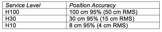
The Arrow 200 Bluetooth GNSS receiver by Eos Positioning Systems now supports the new Atlas H10 GNSS correction service. Using the H10 service, the Arrow 200 GNSS receiver is able to achieve 8-cm accuracy, in real-time, virtually anywhere in the world, the company said. The H10 corrections are delivered by geostationary satellite or via Internet connection.
The Hemisphere GNSS Atlas correction service, announced in June, is a real-time correction service that meets or exceeds existing correction services. It has three service levels, with H10 having the highest accuracy.
“Eos is proud to introduce the first GNSS receiver that supports the H10 service,” said Chief Technology Officer Jean-Yves Lauture. “It will allow our customers in every country in the world to have access to sub-decimeter real-time accuracy on all mobile platforms, including iOS, Android and Windows devices.”
The H10 correction service and the Arrow 200 support all active constellations including GPS, GLONASS, Galileo, BeiDou and QZSS, giving the user ultra-fast convergence time to real-time decimeter accuracy, Eos Positioning said.
The Arrow 200 employs long-range (1 km) universal Bluetooth connectivity so the user can interface to any brand of smartphone or tablet, whether it’s iOS, Android or Windows-based. The Arrow 200 has been optimized to run all day on battery power. The battery pack is field-replaceable and rechargeable separately. All Arrow receivers have been designed to meet IP-67 specifications for immersion in water and are completely dust-proof so they will survive in the harshest environments.
The Arrow 200 GNSS receiver with Atlas H-10 service is targeted at high-accuracy applications like GIS, environmental, agriculture, electric/gas/water utilities, surveying, machine control, and federal, state and local government.
AGCO and Trimble are partnering to deliver wireless connectivity between AGCO’s VarioDoc and AgCommand systems and the Trimble Connected Farm solution. The functionality is expected to be available to customers in North America in September and in Europe, Africa and the Middle East in the fourth quarter of 2015. AGCO is a worldwide manufacturer and distributor of agricultural equipment and infrastructure.
The collaboration allows customers to access their AGCO machine data via AGCO’s telemetry product AgCommand, as well as their agronomic data through AGCO’s VarioDoc task file management platform, from within the Trimble Connected Farm dashboard. This deeper integration of AGCO and Trimble technologies delivers a more streamlined approach to total farm management, simplifying the grower’s ability to access and act on live machine and task data within a single, Web browser-based user interface, the companies said in a statement.
“The inclusion of AGCO’s AgCommand information into Connected Farm aligns well with Trimble’s continued focus on providing a complete solution for growers to manage a mixed fleet of vehicles and implements,” said Joe Denniston, vice president of Trimble’s Agriculture Division. “AGCO customers now have access to one central location in Connected Farm for monitoring their farm operations including fleet data, rainfall and weather information, commodity quotes, and irrigation monitoring to enable improved decision making from the office to the field.”
“This collaboration gives our customers easier access to their operational data for enhanced productivity, mobility and decision making,” said Eric Hansotia, senior vice president, Global Harvesting, Crop Care, Advanced Technology Solutions and Dealer Tech Support at AGCO. “Strategic development with platforms like Connected Farm gives growers a single location from which to monitor their entire operation.”
The development expands on the February 2014 announcement of the connection between Trimble’s Farm Works Software and VarioDoc. This new integration will give Trimble customers the option to sync their task data sent via VarioDoc in either Farm Works or Connected Farm.
The integration between Trimble’s Connected Farm and AGCO’s AgCommand will be the first to utilize AGCO machine data via the AgCommand API (Application Programming Interface). The API will open globally in the fourth quarter of 2015 to developers and service providers who wish to incorporate machine data into custom applications and tools for growers. This offers more points of access to end users, allowing AgCommand data to be integrated into the grower’s farm management platform of choice.
Trimble joins AGCO’s growing list of partners that are part of AGCO’s Fuse Technologies open approach to precision agriculture and precision machine management.
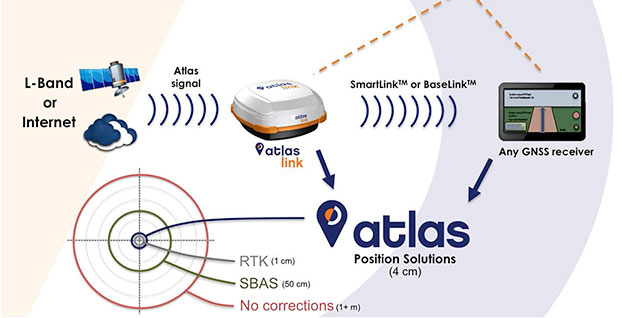
Hemisphere has released Atlas, its new entrant into the GNSS global correction services market. Atlas is delivered via L-Band or the Internet at accuracy levels ranging from meter level to sub-decimeter level. Atlas support is being introduced across a wide range of hardware, including Hemisphere’s new AtlasLink smart antenna, also launched.
“Atlas comes out of a change of culture and focus,” Hemisphere CEO Chuck Joseph told GPS World in an extensive interview that also included Rodrigo Leandro, Hemisphere’s director of engineering, GNSS Positioning Systems. For the full interview, see the second half of this news story.
Starting June 19, Atlas will be available for subscription at the dedicated Atlas web portal across a range of Hemisphere’s multi-frequency, RTK-capable products, such as AtlasLink, R330u, V320 and VS330u. Atlas will also be available from a number of Hemisphere’s channel partners and OEMs such as Carlson Software, Inc.
“Since joining Hemisphere I have heard from customers large and small that they need a different option when it comes to high-accuracy corrections, one they can buy from their provider of choice and with little to no impact on their operating budgets,” said Chuck Joseph, Hemisphere GNSS CEO and president. “We listened hard to what they told us and built Atlas to answer their needs — a totally new service that delivers freedom of choice to our customers along with industry leading corrections at dramatically reduced prices.”
“We formed a team of our most experienced GNSS professionals with the task of developing a roadmap for the future of correction services business and technology in the world — assessing current needs, and also what users across the globe will be looking for over the next decade or two,” said Rodrigo Leandro, Hemisphere director of engineering. “Atlas not only introduces Hemisphere as a business and technology leader in the correction services industry today, it also provides an essential platform for delivering multiple levels of correction services to a very wide range of users spanning commercial business and consumer application use.”
Systems supporting Atlas utilize the newly released and proven Athena GNSS engine. To be able to utilize Atlas corrections, users of supported systems will simply need to update to Athena firmware and purchase a subscription through the Atlas portal.
To build Atlas, Hemisphere GNSS put together a team of seasoned developers whose collective experience matches the best in the GNSS industry. Together they have developed a GNSS correction service, available via L-Band satellite broadcast, which utilizes the most powerful technologies available to deliver a service that matches or exceeds competitive systems across a range of metrics:
Positioning accuracy: Atlas provides competitive positioning accuracies down to 2 cm RMS in certain applications.
Positioning sustainability: Position quality maintenance in the absence of correction signals, using Hemisphere’s Tracer technology.
Scalable service levels: Atlas is designed to serve all. It is capable of providing virtually any accuracy, precision and repeatability level in the 5 to 100 cm range.
Convergence time: Convergence times of 10-40 minutes.
Exclusive agnostic capability: Atlas is an agnostic positioning system. SmartLink technology allows an AtlasLink antenna to be used as an Atlas signal extension for any GNSS system compliant with open communication standards.
Network RTK augmentation: BaseLink technology allows Atlas-capable receivers to self calibrate, self-survey, and automatically manage the transmission of RTK correction data to augment or extend established or new GNSS reference networks in areas of poor Internet connectivity.
“High-quality corrections are essential to our customers,” said Randy Noland, director of Machine Control, Carlson Software, Inc. “The way all the existing services are purchased, delivered and supported is completely separated from the rest of the positioning ecosystem. We see Atlas as an opportunity for us to deliver corrections under our own brand as part of a holistic package — all of which means empowering our ability to provide a stronger solution and a better experience for our customers.”
“Atlas completely changes how augmentation services are delivered and supported,” said Andy Smith at Saderet Ltd. “For the first time, distributors and dealers can fully participate in selling to and supporting our customers, strengthening our relationships by providing them with a much better experience.”
“I’ve extensively tested Atlas, and the performance is exceptional, making it a great fit for our GIS and survey customers” said Jean-Yves Lauture at Eos Positioning Systems, Inc. “Even better, we can now offer global augmentation services with our Arrow GNSS receivers to our customers as part of an integrated solution. After many years in this industry, that’s a major change.”
Atlas service levels and position accuracies can be customized to meet OEM needs, the company said.
Exclusive Interview with Hemisphere’s Chuck Joseph and Rodrigo Leandro
A Startup Inside a Reinvention
“Atlas comes out of a change of culture and focus,” Hemisphere CEO Chuck Joseph told GPS World, in an extensive interview that also included Rodrigo Leandro, Hemisphere’s director of engineering, GNSS Positioning Systems. “We are reinventing a storied brand, and to do that we have to act more like the startups I have directed since leaving Trimble — move fast, be flexible, and focus on innovation. Effectively we are building a startup inside of a reinvention.”
“On my first day on the job, we divided the staff into five working groups and told them: you are now startup companies, entrepreneurs, with six people each team. Go away and come back with big ideas. Go build a business plan. Out of that we got Athena, released last month, Atlas, AtlasLink, and a couple more new products coming out in the months to come.”
A Different Kind of Corrections Service
Joseph and his colleagues at Hemisphere describe the distribution, pricing, and overall business model of Atlas as “disruptive.”
“Our approach comes directly from talking to customers in agriculture, machine control, and to our channel partners. Other corrections service providers did not allow them to participate, forced them to give up their end user list, and to buy directly from [the service provider] — who in some cases was their competitor in that market.”
“When you step back you can see the impact of those restrictions — after 10 plus years the corrections service marketplace generates probably $150 million in total revenue — it should be bigger than that by now. We think a different approach combined with a very aggressive price point will substantially broaden the marketplace.”
“We’ll be making announcements of OEM signings in the months to come. For us it’s all about what works for our partners — some of them will private-label the service, some will choose to use the Atlas brand. We really don’t care if our name is on the product or not — we’re an OEM play. Whatever brand they choose, we will provide them with the infrastructure to be successful, even down to the portal their customers will use to manage their devices and subscriptions — we will develop that for them, and provide the back-end e-commerce.”
A Look at the Technology
Rodrigo Leandro added, “The basic architecture is not extremely different from other L-band reference services. However, within that, we have really pushed to develop leading-edge technology. For example, our correction method format is well-developed for new constellations and different applications it can serve, and our corrections message structure is the most advanced of those available today. As a result, we have a number of patents pending on technologies included in Atlas.”
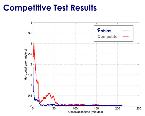
Chuck Joseph interjected, “When we were doing the initial planning for Atlas we agreed that it was absolutely critical that our performance meets or beats the competition’s, otherwise we wouldn’t want to offer it to customers out there. We have been benchmarking the competition at every stage of our development, and know that we are delivering a market leading product.”
“This slide shows the same, single antenna connected to Atlas and to a competitor, and it shows being able to converge down to decimeter level.
“This one gives more details on time to converge.
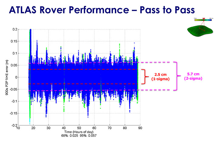
“And here, this one shows pass-to-pass results, the relative accuracy between 2 tracks of the tractor — this is important for people more interested in agriculture applications. We can get down to 2.5 centimeters.”
“The new AtlasLink antenna is designed to be a main channel for customers of our service. It can be used in GIS, machine control, marine applications and so on. Features inside it include a very big internal memory storage, a web server application, multi-GNSS multi-frequency capability, L-band and RTK — it supports Atlas and Athena out of the box. Other innovations will come later, for instance, incorporating Galileo. We believe it is the most powerful multi-purpose GNSS smart antenna in the industry.”
“At the same time there is easy support and easy configuration by the user. It takes literally about six clicks from log-in to register the receiver, out of the box. In 20 minutes you’re running Atlas. It’s very easy to get up and running.”
Broadening the Market
Leandro continued, “The Atlas service isn’t the only area of innovation however. We also spent a lot of time working on how we could deliver the service to the broadest possible audience, and the resulted in two key features of our AtlasLink antenna — SmartLink and BaseLink. Those features free customers from the restrictions of their current hardware and current service — they really change the game.”
“Customers don’t want to have to buy a new $10-$20K receiver [in order to get a corrections service]]. If you’re happy with the hardware you’re currently running, there’s no need to change it, you can still get this service. We are not in the business of using the service to sell hardware. We are using the hardware to sell the service.”
Joseph concluded, “This is all good for OEM customers. For them the SmartLink and BaseLink capabilities are huge. They can go back into their installed base and not have to push people to upgrade receivers or get a brand new receiver. At the same time, it enables them to go after their competitors installed base, and opens up markets that previously weren’t available such as recreational marine service, for example, the lower end of the marketplace. Fundamentally, we want to change this market — enable more users to get access to correction, and deliver real choice to those that have it already.”
NORAC provides advanced automated boom height control technology for the global agricultural marketplace. Its current product line includes systems to precisely maintain a spray boom height above the top of the crop or the ground to ensure optimum application of needed fertilizers and plant protection products.
The agreement marks the third precision agriculture-related purchase Topcon has made since November 2014. It adds an additional engineering and manufacturing facility in Canada and raises the total number of Topcon employees dedicated to precision agriculture solutions to more than 700.
“For more than 40 years NORAC has created innovative solutions to improve efficiency on the farm,” said Ray O’Connor, president and CEO of Topcon Positioning Group. “Its automated boom height control technology has transformed the use of agricultural sprayers. We are excited to unite with another precision agriculture leader, especially one that has established its leadership in a way that mirrors the growth of Topcon — by being the first to bring best-in-class technology to the market.”
“It’s another example of our optimism for investing in the agricultural marketplace,” said O’Connor. “Topcon is committed to developing automation and management solutions that bring the power of the Industrial Internet of Things (IIoT) to every farm.”
“We are thrilled to have the opportunity to join the Topcon family,” said Bill Strelioff, president and CEO of NORAC Systems International. “NORAC and Topcon have collaborated well in numerous precision agriculture development projects and know that our synergistic technologies and distribution channels make this a great fit. But just as importantly, we recognize that our company cultures are very closely aligned. That’s the real key to multiplying the benefits of this union.”
Founded in 1974, NORAC pioneered automated boom leveling, and currently enjoys a leading market share within the agricultural industry. In addition to the headquarters in Saskatoon, Saskatchewan, Canada, three branch offices include NORAC, Inc. (Minnesota, U.S), NORAC Europe sarl (Guéreins, France) and NORAC Trading (Shanghai, China).
“We are excited to welcome the skilled employees at the world-class facilities of NORAC to the precision agriculture team at Topcon,” said Albert Zahalka, president of Topcon Precision Agriculture. “As a global leader for boom leveling, NORAC will add considerable strength to our original equipment manufacturer (OEM) offering, and is an ideal complement to our extensive portfolio of innovative precision agriculture solutions.”
The MachineryGuide package with antenna, receiver and guidance software.
MachineryGuide is a new GPS guidance system for Android that gives farmers the ability to use their smartphones for precision guidance.
With the help of MachineryGuide, the cultivated area and overlaps can be displayed. The guidance application helps farmers in edging along the ideal track by gearing to straight reference lines.
With the application and an antenna from MachineryGuide, farmers can have a simple precision guidance application to improve yield growth, increasing efficiency. Also, fertilizer and pesticide use can be optimized, while machine costs and work hours can be lowered by up to 10 percent, the app designers said.
The application is aimed at managers of small- and medium-sized farms and can be used on a smartphone or tablet. A demo can be downloaded from GooglePlay — the free version can not connect to a real GPS device, but all the functions of the program can be tested.
MachineryGuide sells the software separately; a GNSS receiver + antenna separately; and a package bundle that includes software, GNSS receiver and antenna. The antenna is capable of receiving and processing free corrections (EGNOS, WAAS).
Marketsandmarkets.com is offering a new report on the precision farming market, with forecasts to the year 2020. The report covers various technologies and components, including GNSS.
The report is titled “Precision Farming Market by Technology (GPS/GNSS, GIS, Remote Sensing & VRT), Components (Automation & Control, Sensors, FMS), Application (Yield Monitoring, VRA, Mapping, Soil Monitoring, Scouting) and Geography – Global Forecasts to 2020.”
According to marketsandmarkets.com, “Precision farming is growing rapidly from its infancy towards maturity. Driven by advancements in data management, precision farming has a remarkable impact on traditional approaches to farming. Applying technological developments in data collection and geo-location tracking, precision farming uses technology to optimize yield and detect operating efficiencies as well as deficiencies. Precision farming applications guide farmers about the right time to plant and harvest, and the amount of fertilizers and pesticides needed for better yield production. This information helps cut down input costs, fuel usage, and labor, and negate the environmental impact. Farmers across the globe have been benefitted due to innovations in precision agriculture.
“Major drivers for this market are augmented yield and profitability, which are contributing factors for farmers to opt for precision farming; other drivers like energy and cost saving, and government assistance have also been contributing to the market growth. Major restraints like high initial investments, and lack of awareness and their impact analysis are also covered under this study.
“The total precision farming market size is expected to grow at a CAGR of 12.2% from 2014 to 2020 and reach $4.55 billion by 2020. The report analyzes the precision farming supply chain, giving a very clear insight of all major segments and supported segments to the industry. The report also provides a detailed scrutiny of the Porter’s five force analysis for the market. All five major factors in these markets have been quantified using internal key parameters governing each of them.
“The report also includes company profiles of leading players in this industry with their recent developments and other strategic business activities. The competitive landscape section of the report entails key growth strategies and detailed market share analysis of key industry players. Some of the major players in the precision farming market are AgJunction Inc. (U.S.), Ag Leader Technology (U.S.), Dickey-John Corporation (U.S.), Teejet Technologies (U.S.), Deere & Company (U.S), Trimble Navigation System (U.S.), Precision Planting Inc. (U.S.), ACGO Corporation (U.S.), Topcon Precision Agriculture (U.S.), and Raven Industries Inc. (U.S.).”