Category: Machine Control / Agriculture

  • What Happened to Piksi, the $995 RTK GNSS Receiver on Kickstarter?

    What Happened to Piksi, the $995 RTK GNSS Receiver on Kickstarter?

    Piksi
    Photo: Piksi

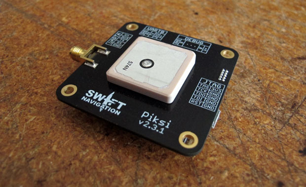
    A little more than a year ago, Swift Navigation started a Kickstarter campaign for a $995 RTK GNSS receiver named Piksi. The goal was to raise $14,000 for the project. By the time the Kickstarter campaign was ended, Swift raised $166,097 from 303 backers.

    I wrote an article about the Swift’s Kickstarter campaign in September 2013, a few days before the fundraising period ended. Following is a two-minute Kickstarter promotional video describing Piksi.

    At the time, the $995 price for the Piksi raised a lot of eyebrows and generated conversations in the high-precision GNSS user community about inexpensive RTK technology.

    This week, I took the opportunity to catch up with Swift to see how the project is going and where the company is headed.

    I spoke with Tim Harris, CEO of Swift, and Fergus Noble, chief technology officer. Tim said they delivered most systems to their backers in April (2014) as well as issuing “very few” refunds, which is not unusual for Kickstarter projects. As of today, Tim said there are about 1,000 units in the field among 350+ users. He said they still consider the Piksi to be in beta testing phase and expect production units to start shipping next year.

    “We are in RTK reliability mode now” — Fergus Noble

    Fergus said that the hardware design is stable and hasn’t changed since they shipped Piksi last spring. He said the focus has been on refining the RTK firmware to make it robust and reliable for professional use. He admits that “covering all corners” has been a challenge and, according to Swift’s blog, “The RTK software has been a tougher nut to crack than we originally anticipated.” This is especially ambitious, since Swift said they developed the RTK firmware based on published academic technical papers, combined with their own techniques (preparing patent applications) to run on a low-power hardware platform. Basically, they started from scratch, and without any RTK veterans on their team. You gotta love their guts.

    Apparently, the venture capital world liked what they saw. A few months ago, Swift, based in San Francisco, secured $2.6m in seed funding from Fall Line Capital, Felicis Ventures, Kal Vepuri, Lemnos Labs, Qualcomm Ventures and VegasTechFund. With the additional funding, Swift has increased its headcount from 4 to 9.5.

    The Devil Is in the Details

    Swift Navigation Lodestar
    Swift Navigation Lodestar. Photo: Swift Navigation

    Start-ups like these are a cool story, but at some point the rubber has to hit the road. Piksi is a long way from being an RTK product that you and I use for GIS and surveying, and Tim/Fergus are humble enough to admit this. The founders see the Unmanned Aerial Systems (UAS) market as their key customer base due to Piksi’s micro-size and low cost. They say this is reflected in their current customer base, which is comprised largely of UAS users, then surveying and agriculture, with the remaining 20 percent being a variety of apps like augmented reality. I agree that UAS is the right segment for them to focus on. At this point, the limitations for general surveying and GIS use are too great:

    • Must use a Piksi RTK base due to the proprietary protocol. In other words, not compatible with existing RTK base stations or networks.
    • Baseline length (distance between the RTK base and rover) must be very short. They haven’t done much testing even with a one-mile baseline.
    • RTK initialization is spec’d at 15 minutes, although Fergus said it’s typically 7-10 minutes.

    Since Piksi is only a single-frequency receiver (L1), it has the same limitations as other L1 RTK systems we’ve seen marketed over the past few years — short baselines and long initialization times compared to dual-frequency receivers. While these limitations are significant for surveying and GIS users, they aren’t as significant for UAS users, since UAS users require line of sight to the aircraft at all times and UAS are operated in a clear-sky environment.

    Communications

    If you’ve used RTK, you are aware of the importance of data communications between the base and rover. As part of its kit, Swift supplies license-free, 915MHz frequency-hopping radios to facilitate communications between the base and rover for testing. However, the founderse make it clear that they aren’t in the data radio business. They expect that most Piksi users will incorporate their own communications technology. Swift is discussing incorporating GSM (mobile phone) modem capabilities in the future.

    Future

    In 2015, Swift plans to roll out the Piksi in production quantities, so Fergus said their focus is on creating a robust and professional RTK system. Of course, the burning question is if/when Swift will incorporate a second GPS frequency into its receiver to take advantage of the faster RTK initialization and longer baseline distances that a dual-frequency receiver offers. Swift isn’t willing to talk about that right now. Said Tim, “We’re holding our plans close to our chest.”

    Thanks, and see you next month.

    Follow me on Twitter at https://twitter.com/GPSGIS_Eric

  • Drone Prohibition: NTSB Rules Favorably on FAA Appeal

    The U.S. National Transportation Safety Board has ruled that drones are aircraft for the purpose of the Federal Aviation Administration’s prohibition of their careless or reckless use.

    The NTSB affirmed the agency’s position that unmanned aircraft systems (UAS) meet the legal definition of “aircraft,” and that the agency may take enforcement action against anyone who operates a UAS or model aircraft in a careless or reckless manner.

    The FAA appealed a decision by an NTSB Administrative Law Judge in Huerta v. Pirker, after the judge dismissed the FAA’s order requiring Raphael Pirker to pay a civil penalty of $10,000 for operating an unmanned aircraft in a careless or reckless manner at the University of Virginia in October 2011.

    The FAA said in a statement, “The FAA believes Mr. Pirker operated a UAS in a careless or reckless manner, and that the proposed civil penalty should stand. The agency looks forward to a factual determination by the Administrative Law Judge on the ‘careless or reckless’ nature of the operation in question.”

    Commercial drones are currently banned in the U.S., except for certain exemptions like one announced in September for some TV and movie production companies, as reported by PC World. Amazon.com and Google have said they plan to use drones to deliver goods. The FAA is required by U.S. Congress to frame a “safe integration” plan for the commercial use of UAS by Sept. 30, 2015.

    The NTSB was ruling in an appeal against an FAA order that imposed a fine of $10,000 on aerial photographer Raphael Pirker in October 2011 for flying recklessly a powered glider aircraft near University of Virginia at Charlottesville, Virginia. Pinker was said to have been hired to supply aerial photographs and video of the university campus and medical center. He had argued that his aircraft, which was described as an UAS, was in fact a model aircraft.

  • Topcon Acquires in-Cab Mounted Console Manufacturer

    Topcon Positioning Group has completed the acquisition of Wachendorff Elektronik GmbH and Wachendorff Electronics Inc. in a private transaction.

    Wachendorff Elektronik GmbH and its U.S. subsidiary Wachendorff Electronics, Inc., are manufacturers of in-cabin mounted consoles for the industrial vehicle market in the agricultural and construction industries.

    “This acquisition is a key ingredient of our global strategy to strengthen our ability to serve original equipment manufacturers (OEM) and establish the foundation for Topcon manufacturing in Europe,” said Ray O’Connor, Topcon Positioning Group president and CEO. “This world-class facility in Germany is second-to-none in its operational quality, employee dedication, and astute leadership — all of the characteristics needed to exceed the high-precision standards required for our industry.”

    “This transaction is an example of our commitment to expand our portfolio of high-quality products and become the world’s leading provider of in-cab consoles for the agricultural and construction OEM markets,” said Albert Zahalka, president of Topcon Precision Agriculture and leader of the acquisition team.

    The Wachendorff family founded Wachendorff Prozesstechnik GmbH & Co KG in Geisenheim, Germany in 1978. Wachendorff Elektronik was founded in 1985.

  • Yield Monitoring Market Worth $2.51 Billion by 2020

    According to a new market research report published by MarketsandMarkets, the total Yield Monitoring Devices and Services Market is expected to reach $2.51 Billion by 2020, growing at a CAGR of 7.17% from 2014 to 2020.

    The report, “Yield Monitoring Devices and Services Market by Technology (GPS/GNSS, GIS, Remote Sensing), Components (Sensors, GPS/GNSS, Display, Guidance & Steering, and Software & Services), Application (VRA, Field Mapping, Soil Monitoring, and Scouting), and Geography – Global Forecasts to 2020”, is available now. It includes 65 market data tables and 64 figures spread through 208 pages and an in-depth TOC.

    Yield monitoring is considered by farmers to be essential as yield data is recorded automatically while harvesting crops. Yield monitoring and mapping offers many other on-farm and off-farm benefits such as real-time availability of information, creation of a spatial database, and evaluation of whole-field improvements. Yield monitoring devices and services are implemented for site-specific farming, which ensures better efficiency, high yield, and profitability with optimum usage of resources. Yield monitoring techniques have major applications in variable rate application (VRA), soil monitoring, field mapping, and crop scouting.

    Despite the rapid growth of global commerce and the widespread availability of equipment for yield monitoring and VRA, adoption rates appear to differ sharply from one country to another. The increasing demand for food is propelling the growers to adopt yield monitoring techniques and optimize their resources efficiently with minimum wastages.

    The report provides a detailed segmentation by technology, component, and application. The geographic analysis covers all existing and emerging technologies in the yield monitoring devices and services market. The market based on technology is segmented into guidance system and remote sensing. The market based on hardware components and software is segmented into hardware components such as sensors, GPS/GNSS devices, display devices, guidance, and steering; and software services such as yield data management software as well as consulting and training services. The report also covers major applications of yield monitoring techniques such as field mapping, VRA, soil monitoring, and crop scouting with qualitative and quantitative industry insights.

    One of the objectives of the report is to analyze market trends for each of the Yield Monitoring Devices and Services Market segments and their respective growth rates. Apart from market segmentation, the report also covers an in-depth analysis such as Porter’s five force analysis, supply chain with a detailed process flow diagram, and market dynamics such as drivers, restraints, and opportunities for this market.

  • Farmers Edge Closes Investment for Precision Farming

    Farmers Edge, a precision agriculture and independent data management solutions company, has received an investment from Kleiner Perkins Caufield & Byers’ Green Growth Fund. With operations around the world, Farmers Edge provides a plug-and-play technology solution that helps farmers optimize crop inputs and maximize yield. The investment from Kleiner Perkins will fund expansion of Farmers Edge’s technology platform and support the company’s continued growth in international markets, Farmers Edge said.

    “We see a huge market opportunity for Farmer’s Edge approach to precision agriculture. They uniquely integrate real-time satellite imagery and in-field telematics to maximize yield and minimize environmental footprint,” said Kleiner Perkins Partner, Brook Porter. Farmer’s Edge is leading the current disruption around how crops are grown, and ultimately how crops are valued as traceability becomes an increasingly important factor in the food supply chain.”

    On the heels of a recent acquisition, Farmers Edge has introduced FarmCommand, a comprehensive solution that provides farmers plug-and-play real-time equipment diagnostics and logistics telematics to any brand of equipment. FarmCommand will become part of the Precision Solutions product line that incorporates field-centric data such as drone and satellite imagery, soil testing, weather stations and precision agronomy. By coupling cloud-based software, Precision Solutions and FarmCommand, with an agnostic hardware solution, growers gain the ability to make comprehensive precision farm management decisions.

    “We rely on Farmers Edge to function as an independent advisor, providing us with a no-hassle, turnkey solution to increase our profitability,” said Jerry Machacek, grower at Canora, SK. “They bring a level of hands-on service that is unique in the industry which is the reason we trust them with the management of our acres.”

    “From seed selection to yield data analytics, we bring all the information together to make a meaningful impact on production and we stick by our customers to ensure the job gets done right,” said Wade Barnes, president and CEO of Farmers Edge. “We have an established history of partnering with both farmers and leading distributors to deliver products which will benefit the farmer and his trusted advisors.”

  • Live from InterGeo

    Brandenberg Gate InterGeo Photo: GPS World
    Photo: GPS World

    GPS World staff will be reporting from InterGeo October 7-9. The massive trade show, held this year in Berlin, is considered the world’s leading conference trade fair for geodesy, geoinformation and land management. With more than 16,000 visitors from 80 countries, it is one of the key platforms for industry dialogue.

    Staff members attending include GPS World Editor and Publisher Alan Cameron, Survey/GIS Editor Eric Gakstatter, and Digital Editor Joelle Harms. All three are accepting meeting invitations for companies interested in discussing their products and services. Contact [email protected].

    VIDEO PLAYLIST

    PHOTOS

    BLOGS

    InterGeo: The Worldwide GIS Showcase (09/25/14)

    NEWS

    Juniper’s New Rugged Handheld Designed for Data-Collecting Efficiency (10/10/14)

    Sokkia Announces Next-Generation Geodetic Reference Receiver (10/08/2014)

    Altus, Entegra Combine to Provide Tough Tablet with RTK Positioning (10/08/2014)

    Spectra Precision Launches Central Cloud Service, New Software Versions (10/08/2014)

    Topcon Announces Geodetic Reference Receiver and Antenna (10/08/2014)

    New Trimble Products Focus on Geospatial Imagery (10/08/2014)

    Topcon to Add 3D Mobile Mapping System to Product Lineup (10/08/2014)

    Sokkia Introduces NET AXII Measuring Station (10/07/2014)

    Topcon Announces Latest Addition to 3D Layout Line (10/07/2014)

    Trimble Offers Expanded GNSS Portfolio for Surveyors (10/07/2014)

    Trimble Offers Pipeline Construction Software for Oil and Gas (10/07/2014)

    Carlson Software Introduces Surveyor2 Data Collector at InterGeo (10/07/14)

    Carlson Launches GIS360 for Android at InterGeo (10/07/14)

    Hemisphere GNSS Offers New Survey-Grade GNSS Antennas (10/07/14)

    Applanix Offers Single-Board GNSS-Inertial System for UAV Mapping (10/07/14)

    Icaros to Unveil Versatile Nadir/Oblique Aerial Mapping System at InterGeo (10/03/14)

    InterGeo Event Considers Land Management Challenges (10/03/14)

    Trend- and Media-Forum at InterGeo Features Innovation, China (10/03/14)

    Juniper System, Soil Instruments Partner on Geotechnical Monitoring (10/03/14)

    Oxford Technical Solutions Launches Board Set for System Integrators (10/03/14)

    Orbit GT Showcases UAS Mapping Pro at InterGeo (10/03/14)

    Icaros to Demonstrate Measuring Tool for Oblique Imagery at InterGeo  (09/24/14)

    EUROGI Conference to Be Held in Conjunction with InterGeo (08/11/14)


    Join Us for Our Post-Show Webinar

    New Product Trends in UAV, Survey, Mapping, and Geospatial Data Collection and Analysis
    InterGeo Post-Show Report

    Thursday, October 16, 10 a.m. PDT/ 1 p.m. EDT / 5 p.m. GMT

    Summary: UAVs (unmanned aerial vehicles) are taking over the surveying industry, thanks to their ever-improving sensors and the fact that they are getting lighter and can therefore remain in the air for longer. They complete surveying and inspection tasks that would otherwise be difficult to tackle, and do so with impressive cost-efficiency. UAV trends and technology will be among the focal points at the InterGeo conference in Berlin in early October.

    Our correspondents will return with a fresh report, moderated by GPS World Editor and Publisher Alan Cameron and Survey Scene Editor Eric Gakstatter.

    Register for free!

  • u-blox Rolls Out New Module, Outlines Marketing Strategy

    Thomas Seiler, u-blox CEO, holds a drone with GPS embedded.
    Thomas Seiler, u-blox CEO, holds a drone with GPS embedded.

    Several companies at CTIA Super Mobility Week, held in Las Vegas September 9–11, are attempting to find niche opportunities in the crowded machine-to-machine market — and Switzerland-based u-blox is no exception. The company is focusing on the mobile, industrial and consumer-location markets, said Thomas Seiler, u-blox CEO.

    While Seiler says there is no one dominant market for u-blox, the fleet market has been very good for the company. In addition, asset tracking has been a good market, he said.

    “We are also seeing consumer markets such as e-bikes, golf carts, commercial helicopters and drones growing,” Seiler said.

    While many location companies are fretting about government regulation, u-blox is taking the position that most agency requirements have actually helped build the market. “Regulatory requirements have been driving business for us. The [National Highway Traffic Safety Administration] proposes that vehicles report location, speed and direction,” said Nikolaos Papadopoulos, u-blox America president. “The collision avoidance regulations have helped to create an ecosystem that drives business.”

    The company recently rolled out its ODIN-W160 multi-radio module for automotive, industrial, medical and security applications.

    Nick Papadopoulos, president of u-blox America, tells CTIA Super Mobility Week show-goers what they should see at the u-blox booth.

  • Sensonor Showcases STIM300 IMU at ION GNSS+

    Sensonor Showcases STIM300 IMU at ION GNSS+

    The Sensonor STIM300 IMU.
    The Sensonor STIM300 IMU. Photo: Sensonor

    Sensonor will be showcasing its STIM300 Inertial Measurement Unit at Booth 102 at ION GNSS+.

    The STIM300 is a small, tactical-grade, low-weight, high-performance non-GPS aided IMU. It contains three highly accurate MEMS gyros, three high-stability accelerometers and three inclinometers. The IMU is factory calibrated and compensated over its temperature operating range.

    The STIM series is designed for use below and on the ocean, on land, in the air, and in orbit and space. The STIM300 IMU is well suited for stabilization, guidance and navigation applications in the industrial, aerospace and defense markets. It is a crucial building block for inertial navigation systems in UAVs, AUVs, AGVs, UGVs and ROVs, Sensonor said.

    The STIM300 is also used for camera turret stabilization and for use in various handheld devices that require a small IMU to secure operations during GPS outage.

  • Topcon Offers 3D Indicate Grade System

    Topcon Offers 3D Indicate Grade System

    I-33_Topcon-WTopcon Positioning Group has announced a multi-platform 3D indicate grade system, the i-33. The new system features GNSS technology and a graphical display designed to provide a powerful indicate system at an economical price.

    The i-33 allows for quick installation and easy operation on many types of grading and earth-moving machinery, according to Topcon. It is designed for use on a dozer, scraper or any type of machinery used for cut or fill operations.

    “The new system brings the productivity of GNSS-based 3D grade control for all types of applications,” said Kris Maas, Topcon’s manager of machine control product marketing.

    “Indicate GNSS systems have not been an economical reality for many contractors or types of work. In other words, the return on investment for a traditional 3D-MC system did not make it practical for bulk earthmoving or less utilized equipment,” Maas said. “With i-33, the game has changed. Its low cost and quick installation make it the perfect solution for use on multiple pieces of equipment or even sharing between machines. Basically, it eliminates over- or under-cutting and ensures material is moved exactly where it needs to be the first time.”

    The GX-30 graphical display control box keeps the operator “visually informed as to final grade so adjustments can easily be made, eliminating redundant passes and helping to further reduce the need for onsite grade checking,” Maas said.

    The system also includes the new MC-i3 GNSS receiver with Vanguard technology, offering single or dual GNSS antenna configurations, allowing the system to work in a wide variety of applications. The MC-i3 also allows connection to Topcon’s Sitelink3D site management solution that provides real-time data control, machine tracking, reporting and planning in one solution to maintain conformance and improve productivity through all job phases.

  • NovAtel Introduces New IMU to SPAN Line of GNSS Products

    NovAtel Introduces New IMU to SPAN Line of GNSS Products

    NovAtel IMU-ISA-100C.
    NovAtel IMU-ISA-100C.

    NovAtel Inc. has added the IMU-ISA-100C as an inertial measurement unit (IMU) option to its SPAN GNSS+INS line of positioning products. The IMU-ISA-100C is a high-performance, near navigation-grade IMU designed for platform stabilization, general-purpose navigation, photogrammetry, remote sensing, and ground mobile-mapping applications.

    Commercially exportable, the IMU-ISA-100C integrates easily with a NovAtel SPAN capable receiver to provide a tightly coupled 3D navigation solution, NovAtel said. Offering customers continuous position, velocity and attitude (roll, pitch and azimuth) measurements, a SPAN system is stable and available even through periods when satellite signals are blocked or unavailable.

    With the IMU-ISA-100C, customers will receive near navigation-grade performance, at an affordable price point.  The product also features a new enclosure designed to maximize versatility for a range of applications.

    “The compelling aspect of this product is its value — it is a high-end SPAN solution, delivering extremely precise positioning, at an attainable price point,” said Siamak Akhlaghi, NovAtel’s product manager, SPAN. “And without the export constraints, it can be shipped internationally in a timely fashion.”

  • Royal Institute Hosts New Navigation Conference

    Royal Institute Hosts New Navigation Conference

    INC_2015_logoThe Royal Institute of Navigation is launching a new international conference series, tackling some of the biggest issues across the domains of modern navigation: land, sea, air and space.

    The RIN is now accepting abstracts for the conference.

    The International Navigation Conference 2015, set for February 24-26, 2-15, is planned as a first event in a new series of world-class conferences. The first conference will highlight the state of the art in fields such as GNSS and Galileo, indoor positioning, autonomous transport, security and resilience of navigation in the world of cyber attacks, and new quantum technologies. The event will be of special interest to the maritime, aviation, PNT, transport, research and development and security communities.

    Speakers, and the topics they will discuss, include:

    • Privacy In Tracking (smartphones and indoor navigation) – Google
    • Security and resilience — Dana Goward, president and executive director, U.S .Resilient Navigation and Timing Foundation
    • Multi-Constellation GNSS — Gian Gherado Calini, GSA
    • Multi-Sensor Integration — Professor Dorota Grejner-Brzezinska, The Ohio State University
    • Quantum Technologies — Sir Peter Knight, professor of Quantum Optics and Senior Research Investigator, Imperial College London
    • Emerging Trends and Current Challenges — Colin Beatty FRIN, CBiL
    • Autonomy in transport — BAE, ASTREA
    • Legal Aspects of Navigation — Professor Frans von der Dunk, Institute of Space Law, Leiden University

    To learn more, visit the conference website.

  • LORD MicroStrain Offers GPS/INS High-Performance MEMS

    LORD MicroStrain Offers GPS/INS High-Performance MEMS

    The 3DM-GX4-45 by LORD MicroStrain.
    The 3DM-GX4-45 by LORD MicroStrain.

    The 3DM-GX4-45 by LORD MicroStrain is a miniature, industrial-grade GPS-aided inertial navigation system that uses high-performance MEMS sensor technology. It combines a triaxial accelerometer, triaxial gyro, triaxial magnetometer, temperature sensors, pressure altimeter, and dual on-board processors running a sophisticated Extended Kalman Filter (EKF) to provide excellent position, velocity, and attitude estimates.

    It offers a range of fully calibrated AHRS measurements, including acceleration, angular rate, magnetic field, deltaTheta and deltaVelocity vectors. GPS measurements include LLH position, ECEF position and velocity, NED velocity, UTC time, GPS time, and SVI.  The receiver is a 50-channel u-blox 6, which receives GPS L1 C/A code, and the SBAS signals WAAS, EGNOS, and MSAS.

    The 3DM-GX4-45 provides accurate navigation and orientation under dynamic conditions for applications such as GPS-aided navigation; unmanned vehicle navigation; camera stabilization; robotic control; and reconnaissance, surveillance, and target acquisition.

    Learn more at the LORD MicroStrain website.