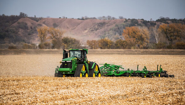
John Deere has introduced the second generation of its autonomy kit, which integrates advanced computer vision, AI and camera technology to enhance machine navigation in various environments. This development comes in response to widespread labor shortages across multiple industries, the company said at CES 2025.
The agricultural sector faces a significant challenge, with the American Farm Bureau Federation estimating that approximately 2.4 million farm jobs must be filled annually. Similarly, the construction industry struggles with labor shortages, with 88% of contractors reporting difficulties finding skilled workers. The commercial landscaping sector is also affected, with 86% of business owners struggling to fill open positions.
“Our agriculture, construction and commercial landscaping customers all have work that must get done at certain times of the day and year, yet there is not enough available and skilled labor to do the work,” said Jahmy Hindman, chief technology officer at John Deere. “Autonomy can help address this challenge. That’s why we’re extending our technology stack to enable more machines to operate safely and autonomously in unique and complex environments. This will not only benefit our customers but all of us who rely on them to provide the food, fuel, fiber, infrastructure and landscaping care that we depend on every day.”
New autonomy kit
The new autonomy kit is being implemented across various machines, including the 9RX tractor for large-scale agriculture, the 5ML orchard tractor for air blast spraying, the 460 P-Tier autonomous articulated dump truck for quarry operations and an autonomous battery electric mower for commercial landscaping. These machines feature advanced camera systems, lidar sensors and improved depth calculation capabilities, allowing for more efficient and precise operations.
John Deere offers multiple adoption paths for users, with select machines being autonomy-ready from the factory and retrofit kits available for certain existing machines. The autonomous machines are managed through the John Deere Operations Center Mobile, a cloud-based platform that allows users to control and monitor the machines remotely, access live video and data and receive notifications about job quality or machine health issues.
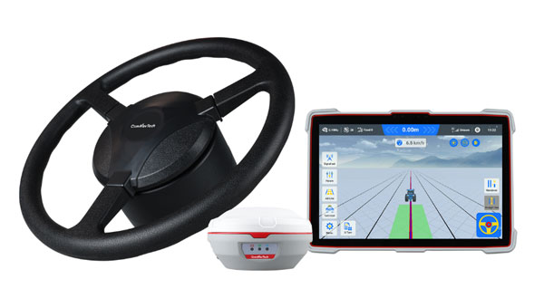
ComNav Technology has introduced the AG501 Pro autosteer system, an advanced solution for precision agriculture. This system offers improved accuracy and efficiency for various farming operations. The AG501 Pro features a streamlined design, incorporating the A100 Pro Smart Antenna, which integrates a GNSS antenna, GNSS module, gyroscope and datalink functionalities into a single unit.
The system utilizes ComNav’s high-performance GNSS module, which supports full-constellation tracking. By employing GNSS+INS terrain compensation technology, the AG501 Pro can achieve a pass-to-pass accuracy of 2.5 cm across diverse terrains, minimizing skips and overlaps.
It also includes free signal options, such as Galileo-HAS and Beidou-B2B services, allowing 5 cm to 10 cm accuracy without the need for mobile RTK base stations or RTK service subscriptions. This is particularly beneficial in areas with poor internet connectivity.
The AG501 Pro offers a variety of guideline options, including parallel straight lines, curves, A+ Heading and automatic U-turns, catering to different farming procedures. It operates within a speed range of 0.1 to 20 km/h and is compatible with major brands and various machine types, including tractors, sprayers and combine harvesters. The system’s user-friendly software interface seeks to simplify configuration and task management. It allows for quick AB line setting and easy engagement of the autosteer function. Additionally, the AG501 Pro software supports multiple languages, making it accessible to farmers worldwide.
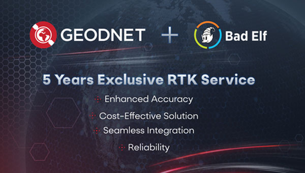
Bad Elf and GEODNET have introduced a five-year RTK service for Bad Elf GPS receivers, designed to provide high-accuracy GPS positioning for professionals in surveying, agriculture, construction and geospatial data collection. The service offers real-time centimeter-level accuracy, designed to improve the precision of GPS data for users.
Benefits of the RTK service for Bad Elf GPS receivers:
Enhanced accuracy: Achieve centimeter-level accuracy in real-time to improve the precision of GPS data.
Seamless integration: The RTK service is designed to work with all Bad Elf GPS receivers, with one-click activation after setup.
Reliability: GEODNET’s robust network offers continuous and reliable service, even in challenging environments.
The RTK service is priced at $999 for five years, offering a long-term, cost-effective solution for professionals. It is compatible with all Bad Elf GPS receivers, including the Flex and Flex Mini models, and can be activated with a one-click setup process.
GEODNET’s network underpins the service, aiming to provide continuous and reliable performance across various environments. The company guarantees the availability of an RTK reference station within 40 km for subscribers in the United States and Europe, with potential expansion to other countries based on demand.
Geospatial professionals using iOS or Android devices can access the RTK corrections in supported regions, enabling them to perform complex location-based tasks with increased confidence in their GPS data accuracy. This service represents a significant development in the field of high-precision GPS technology, offering an integrated solution for professionals requiring accurate positioning data across multiple industries.
Burro, an agricultural robotics provider, and GEODNET, a blockchain company providing precise GPS positioning solutions, have entered a strategic partnership to integrate GEODNET’s real-time kinematic (RTK) GPS technology into Burro’s autonomous robots.
Burro’s autonomous robots are designed for material transport in various agricultural settings, including nurseries, fields and farms. These robots utilize advanced artificial intelligence, computer vision and lidar technology to perform tasks with high precision. Integrating GEODNET’s RTK GPS technology seeks to significantly improve the robots’ navigation accuracy and operational efficiency, particularly in areas where reliable GPS coverage is crucial.
RTK can provide centimeter-level precision, compared to the 2 m to 4 m accuracy of traditional GPS systems, GEODNET said. The increased precision reduces overlap in field operations, minimizing fuel usage and time required to complete tasks. Precise positioning enables more accurate application of seeds, fertilizers and pesticides, reducing waste and improving crop yields.
The partnership between Burro and GEODNET will allow for the provision of RTK corrections and base stations to Burro’s robots. This capability is particularly valuable in regions with limited GPS coverage. The ability to rapidly deploy new base stations offers increased flexibility for users, allowing them to expand their operations quickly and efficiently.
Sodex Innovations, an Austrian company specializing in construction surveying technologies, has unveiled the SDX-4DVision and SDX-Compact machine-mounted terrain mapping systems.
These systems integrate advanced sensor technology and artificial intelligence (AI) driven data processing to create digital twins of worksites while the machine operates. Data is uploaded to the SDX Cloud, allowing for real-time analysis from any location. This allows professionals to monitor evolving site conditions, track inventory through automated volume calculations, and make remote data-driven decisions.
The systems are designed for easy installation on various types of heavy machinery, such as wheel loaders and dozers, making them ideal for construction, mining and civil engineering projects. Their adaptability enables efficient data collection and site monitoring, making them accessible not only to professional surveyors but also to operators and team members who are involved in daily operations.
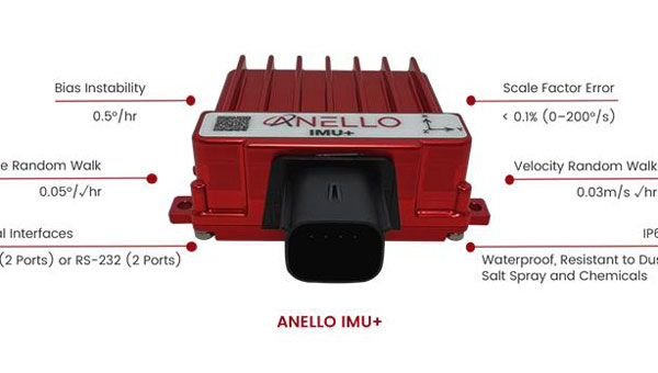
ANELLO Photonics has successfully closed its Series B funding round to advance the development of its silicon photonic optical gyroscope (SiPhOG) technology for navigation in GPS-denied environments.
This funding round was co-led by Lockheed Martin, Catapult Ventures and One Madison Group, with participation from several other investors, including New Legacy, Build Collective, Trousdale Ventures, In-Q-Tel (IQT), K2 Access Fund, Purdue Strategic Ventures, Santuri Ventures, Handshake Ventures, Irongate Capital and Mana Ventures.
ANELLO’s SiPhOG technology integrates high-precision optical fiber gyro performance onto a silicon photonics platform. This innovative solution boasts a low drift rate of less than 0.5° per hour, a compact size comparable to a golf ball, and low power consumption. Additionally, it is designed to withstand shock and vibration while remaining cost-effective compared to traditional fiber-optic gyroscopes.
The technology is tailored for various autonomous applications across multiple sectors, such as land vehicles, UAVs, underwater vehicles, construction and agriculture equipment.
In the context of defense and national security systems, ANELLO’s solutions have demonstrated impressive performance in GPS-denied environments. According to the company, the system can navigate 100 km with less than 100 m of lateral error without relying on GPS and maintains accuracy within 0.1 m over distances of 0.8 km in orchard environments where GPS signals are limited.
ANELLO’s SiPhOG technology aims to bridge the gap between high-performance, expensive sensors such as fiber-optic and ring laser gyros and low-cost, less precise MEMS gyros. This strategic positioning addresses the increasing demand for cost-effective yet high-performance navigation sensors in the expanding autonomous navigation market.
The funding is anticipated to enhance ANELLO’s manufacturing capabilities and product development to meet its goal of delivering reliable navigation solutions for environments where GPS signals are weak or unavailable. These environments include construction sites, agricultural fields, trucking operations, robotics, unmanned aerial and underwater vehicles, autonomous vehicles, as well as defense and national security applications.
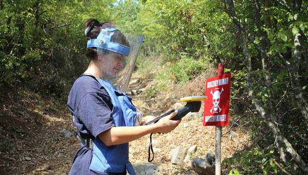
Trimble has expanded support for The HALO Trust, the world’s largest humanitarian landmine-clearance nonprofit organization. Trimble is donating an additional 175 Trimble Catalyst GNSS systems, including Trimble DA2 GNSS receivers, to help The HALO Trust further its demining operations worldwide.
Building on the impact of the ongoing collaboration, Trimble’s latest donation will support the expansion and productivity of The HALO Trust’s mine clearance teams. The Catalyst GNSS system provides The HALO Trust with a solution for deploying precise mapping capabilities to large field teams across broad geographic areas. More field teams can now be equipped with the necessary tools to safely and efficiently clear landmines, thereby accelerating the pace of landmine clearance globally.
Since receiving Trimble’s product donations and the Trimble Foundation Fund-directed grant, The HALO Trust has made significant progress in landmine and unexploded ordnance (UXO) clearance. From January to September 2024 alone, The HALO Trust cleared 802 minefields and battlefields, covering a total area of 10,400 acres across 12 war-torn countries. During this period, 31,209 landmines and other Explosive Remnants of War (ERW) were safely destroyed — all accurately mapped using the Trimble Catalyst GNSS system. The HALO Trust’s use of Trimble technology has significantly improved operational efficiency and provided essential data for safe land reclamation and development. According to The HALO Trust, the accuracy and reliability of Trimble’s technology have been crucial in ensuring the safety and success of demining operations in areas severely affected by conflict, such as Ukraine, Angola and Sri Lanka.
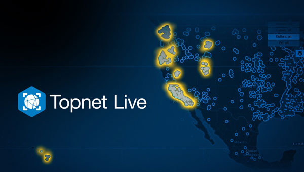
Topcon Positioning Systems has significantly expanded its Topnet Live reference station service, adding 180 full-wave geodetic reference stations across California, Hawaii, Oregon, Nevada, Utah and Washington. This expansion is designed to enhance network corrections, providing centimeter-level accuracy for various industries such as engineering, surveying, construction, and agriculture. The improved service can also benefit specialized applications, including automated mowing, line marking and UAV operations for mapping and delivery in sectors such as the turf industry.
According to Topcon, one key benefit for users is simplified access to globally supported Networked Transport of RTCM via Internet Protocol (NTRIP) network corrections. NTRIP streams GNSS correction data over the Internet, enabling real-time kinematic (RTK) positioning. This technology allows users to achieve high levels of accuracy in their positioning tasks. In addition to NTRIP corrections, the expanded services now include enhanced Differential Global Positioning System (DGPS) coverage, which seeks to improve mapping accuracy.
According to Topcon, Receiver Independent Exchange (RINEX) static files are now more readily available. This enhancement offers more robust static and static kinematic post-processing options. These improvements provide users with more precise positioning data and greater flexibility across a range of applications, from surveying to precision agriculture.
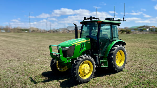
Sabanto has released the Sabanto Steward, a retrofit kit designed to add autonomous functionality to existing tractors. With a simple switch, farmers can seamlessly transition between autonomy mode and standard operator mode.
The Sabanto Steward comprises several key components:
Vehicle Mission Control (vMC): A mobile app that enables users to create, manage, and monitor field operations in real time.
Vehicle Path Finding Module (vPFM): An onboard system that interfaces with the tractor’s steering, power, and hydraulic systems.
Vehicle Operating System (vOS): Software that translates mission control instructions into actual field operations.
Sebanto Steward has successfully executed various field operations across the United States, including mowing, rolling, aerating, rototilling, spraying, seeding, tillage, rotary hoeing and tine weeding. Sabanto’s technology is compatible with various tractor models, including John Deere 5075E, 5100M, 5100E, Fendt 700 Vario and Kubota M5, with plans to expand to more platforms in the future.
Many of us mindlessly shop for food, fuel, clothing, home goods and more without thinking much about where it all comes from, forgetting that in most cases it all started on a farm. Most people are unaware that a key component of agriculture production, besides the soil beneath our feet, is the use of critical technologies such as GPS and other GNSS contstellations. When fully leveraged, technology can be a part of the solution to many of the challenges farmers face today and be a tool in feeding a growing global population.
With technology at their fingertips, farmers across the globe can enhance their productivity through precision agriculture — a practice that uses GNSS technology to maximize agricultural outputs, while reducing farmer inputs and improving sustainability. Precision agriculture is used to till, plant and harvest crops such as corn, soybeans, cotton, peanuts, wheat, tubers and alfalfa. For example, techniques including yield mapping for fertilizer application have been used on fields across the country for more than three decades.
Social and Economic Benefits of Precision Agriculture
According to the U.S. Department of Agriculture (USDA), total U.S. farm output tripled from 1948 to 2021 largely due to advancements in technology — even as farm labor, land and other inputs declined. Farmers needed 8 million fewer acres to produce the same wheat yields in 2018 as in 1990, according to an American Farm Bureau Federation report.
A closer look at four crops commonly tilled, planted and harvested using precision agriculture techniques highlight technology’s economic benefits:
Sweet Corn: The United States is the largest producer of sweet corn at roughly 315 million tons per year, accounting for 34% of global production. There are more than 316,000 U.S. corn farms, 95% of which are family-owned. In 2021, Florida was the largest producer of sweet corn, followed by California, Washington and Michigan. The United States exports 69 million tons of sweet corn annually, yielding a value totaling $9.2 billion. China is the largest buyer of U.S. sweet corn, purchasing 31% of all U.S. exports.
Peanuts: In 2023, the United States produced roughly $1.6 billion in peanuts, led by Georgia — with 55% of total U.S. peanut production — followed by Texas (10%), Alabama (10%), and Florida (9%). In 2023, the United States exported more than $889.5 million worth of peanuts, with Mexico and Canada as top destinations. With new techniques to adjust digger conveyor speeds, yield continues to improve.
Cotton: The United States produces roughly 15 million bales of cotton each year, contributing to a $21 billion industry. Texas boasts the highest number of planted acres with 40% of the U.S. supply (6 million bales), followed by Georgia at about 2.5 million bales. The United States is the world’s leading exporter of cotton, totaling 35% of the total global supply. Farmers are increasingly using autosteer technology to help grow and harvest cotton — with the adoption of precision agriculture equipment jumping from 46% in 2008 to 86% in 2023, according to a survey conducted by Cotton Grower.
Wheat: The United States produces roughly 7% of the global wheat supply — accounting for roughly $12.7 billion — with Kansas, North Dakota, Montana, Texas and Oklahoma producing the most wheat across the country.
Precision agriculture also helps farmers work toward important conservation goals. Auto guidance capabilities and seeding sensors increase tractor and seeding efficiencies, reducing herbicide use by 9% and fossil fuel use by 6%. These small but important changes contribute to a wider effort to employ more sustainable agriculture practices, with precision agriculture and GPS technology sitting front and center.
Through it all, GNSS remains at the forefront of a strong, efficient agriculture system. Whether it’s auto-steering tractor technology or strengthened hydrology practices, new precision agriculture technologies are released every year. If broader adoption of precision agriculture technologies continues, the United States can increase its national crop production by 6%, bolstering the agriculture economy even further.
GPS Innovation Alliance (GPSIA) members Deere & Company and Trimble are at the forefront of advancing precision agriculture techniques globally, creating more opportunities for farmers to boost their productivity and reduce crop loss with innovative GPS and GNSS technologies.
Deere & Company offers several receivers that use GNSS technology to plant crops with accuracy down to the centimeter and coupled with the sensors and computer vision, allow farmers to plant at quicker speeds without damaging crops — including its fully autonomous 8R tractor unveiled in 2022. While Deere & Company had been developing new GNSS receivers for years, a critical partnership with NASA’s Jet Propulsion Laboratory (JPL) in 2004 was groundbreaking. Deere & Company modified its GNSS receivers to tap into the agency’s network of ground stations and incorporated JPL’s software. The innovation allowed them to introduce autonomous tractors worldwide, revolutionizing precision agriculture and leading to a wider acceptance of autonomous tractor technology.
Trimble has brought innovative solutions to precision agriculture since the company first began producing its agricultural GPS receivers in 1997. Since then, the company has unveiled state-of-the-art technologies to support farmers, including RTX technology which uses precise point positioning (PPP) to allow farmers to plant seeds and farm with sub-inch GNSS accuracy. Trimble also has announced several partnerships that strengthen the company’s precision agriculture capabilities from CNH and CLAAS (2011) to Horsch (2021) to AGCO (2023).
In 2022, Trimble deepened its partnership with agricultural machinery manufacturer CLAAS to integrate Trimble’s GPS PILOT system and SAT 900 GNSS receiver with CLAAS’ CEMIS 1200 display, providing farmers greater accuracy when tilling, seeding, spraying, or harvesting their fields. In April 2024, Trimble created a joint venture with AGCO to accelerate the pace of innovation and increase farmer’s access to precision agriculture technology.
Critical Role of Broadband in Precision Agriculture
Reliable broadband connectivity goes hand-in-hand with GNSS technologies and allows full use of agriculture technology and its resulting benefits. According to the USDA, more than 20% of rural households and farms do not have reliable access to broadband, limiting access to new technologies that would enhance efficiency and help farmers grow their businesses.
Industry leaders are working to ensure that farms across the country can reliably access the Internet. For example, Deere & Company, in partnership with SpaceX, is working to close the connectivity gap among farmers with satellite communications (SATCOM) services. Later this year, Deere & Company will begin to offer Starlink satellite communications technology to farmers across the United States and Brazil.
Beyond industry investment, the USDA’s Rural Development Broadband ReConnect Program provides grants and loans to strengthen broadband infrastructure and equipment in eligible rural areas. In addition, the National Telecommunications and Information Administration is overseeing the $42.5 billion Broadband Equity, Access, and Deployment program, intended to expand high-speed Internet access for communities across the country with little to no Internet connectivity. Establishing tech-neutral policies within these and similar programs as well as focusing on delivering coverage to uncovered agriculture lands to the last acre is key to improving efficient agriculture production.
Precision Ag on the Hill
Precision agriculture is also making its way into policy conversations at all levels of government as awareness around agriculture technology and its benefits are realized.
The 2018 Farm Bill established the Task Force for Reviewing the Connectivity and Technology Needs of Precision Agriculture in the United States (“Precision Ag Connectivity Task Force”) within the Federal Communications Commission. The Task Force is currently completing its third and final term this year and will have produced three comprehensive reports with related recommendations for policymakers.
The 2018 Farm Bill expired on Sept. 30, 2023, but was extended for one year to allow the U.S. Congress additional time to come to agreement on the next five-year reauthorization bill. The Farm Bill presents a key bipartisan legislative opportunity to include incentives for agriculture technology adoption. Lawmakers should consider previously introduced standalone legislation, including the PRECISE Act and the PAL Act, to accomplish this goal. Together, these bills would expand existing USDA programs to include precision agriculture technologies and create a new loan program.
Small family farms account for roughly 88% of all farms in the United States but make up less than 20% of all U.S. agricultural products sold. To increase yields and better compete with large-scale farms, farmers are increasingly turning to precision agriculture technologies — though availability remains a challenge. Understanding these statistics, efforts to promote equal access to precision agriculture enjoy bipartisan support from both chambers of Congress.
Reflection
GNSS technology’s role in precision agriculture continues to save farmers time and money, while simultaneously providing conservation-oriented solutions for farmers, consumers and the planet. GPSIA members Deere & Company and Trimble have contributed innovative solutions to precision agriculture technology for decades, enhancing efficiencies through groundbreaking partnerships and expanding opportunities for farmers to use the technology. These innovations, coupled with recent rural broadband expansion efforts, ensure farmers can access the most cutting-edge technology and continue to innovate. The focus on precision agriculture on Capitol Hill is an important reminder of the wider implications of GNSS in our everyday lives and how GNSS systems fit into the U.S. agriculture industry. GPSIA is proud to support its members as they continue to promote the use of innovative GNSS technologies in agriculture.
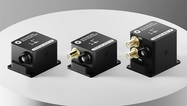
Advanced Navigation has expanded its Certus product line by introducing the Certus Mini series. This development marks a significant advancement in compact and high-performance navigation technology for field robots, autonomous vehicles and UAVs.
The Certus Mini series comes in three variants:
Certus Mini D: A dual-antenna inertial navigation system (INS)
Certus Mini N: A GNSS-aided INS
Certus Mini A: An attitude and heading reference system (AHRS)
These lightweight systems, weighing no more than 55 grams (1.9 oz.), offer impressive performance and cost-efficiency for their size.
The Certus Mini D utilizes dual-antenna GNSS for accurate heading, position, and velocity measurements. It operates on L1/L5 multi-constellation GNSS and offers enhanced interference immunity and position accuracy, particularly in challenging urban environments.
The Certus Mini series is designed to integrate into legacy systems and new builds. Its versatility makes it suitable for various applications, including surveying, agricultural robotics, open-pit mining and asset tracking.
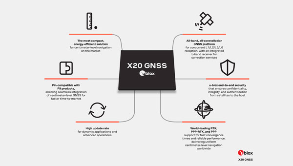
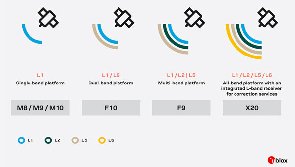
u-blox has introduced the X20, a new high-precision GNSS platform that builds upon its previous F9 platform. The X20 is designed to meet global demands for high-precision GNSS capabilities while accommodating future technologies and standards.
The X20 operates across all GNSS frequency bands (L1/L2/L5/L6) and includes an integrated L-band receiver. The L5 band operates at lower frequencies, which can improve signal robustness, while the L6 band is used for navigation and correction services to enhance positioning accuracy. This comprehensive coverage allows for high-precision positioning even in challenging signal environments.
The platform supports various correction services, including local base stations, real-time kinematics (RTK), network RTK, precise point positioning (PPP) corrections and PPP-RTK.
It is suitable for applications requiring centimeter-level positioning accuracy under challenging environments, such as port logistics, construction machine control, UAVs, autonomous ground robotics (e.g., lawnmowers) and time synchronization for critical infrastructure systems.
The X20 platform incorporates comprehensive security measures such as end-to-end security functions, system authentication via secure boot and firmware updates, message authentication and encryption with a built-in secure root of trust (RoT).
It supports Galileo OSNMA authentication and features advanced jamming and spoofing detection and mitigation. The X20 platform is designed to be software upgradeable, allowing users to adapt to future developments in GNSS technologies and standards.